Construction of a Secondary
Boundary Fence and New Sections
of Primary Boundary Fence and
Boundary
Environmental
Impact Assessment
(Final)
January 2009
in association with
ADI Limited
Archaeological Assessments
Mott MacDonald Hong Kong Ltd
7th Floor,
Tsim Sha Tsui,
Hong Kong
Tel: 2828 5757
Fax: 2827 1823
This
document has been prepared for the titled project or named part thereof and
should not be relied upon or used for any other project without an independent
check being carried out as to its suitability and prior written authority of Mott
MacDonald being obtained. Mott MacDonald
accepts no responsibility or liability for the consequence of this document
being used for a purpose other than the purposes for which it was
commissioned. Any person using or
relying on the document for such other purpose agrees, and will by such use or
reliance be taken to confirm his agreement to indemnify Mott MacDonald for all
loss or damage resulting therefrom. Mott
MacDonald accepts no responsibility or liability for this document to any party
other than the person by whom it was commissioned.
To
the extent that this report is based on information supplied by other parties,
[Mott MacDonald] accepts no liability for any loss or damage suffered by the
client, whether contractual or tortious, stemming from any conclusions based on
data supplied by parties other than Mott MacDonald and used by Mott MacDonald in
preparing this report.
List
of Contents Page
Chapters
1.3 EIAO and Designated Projects
1.5 Need for the Project and
Consequences of not Proceeding with the Project
1.6 Consideration of Alternative
Alignment
1.7 Alternative / Preferred
Construction Methods and Sequence of Works
1.8 Interface with Concurrent Projects
1.9 Objectives of the EIA Study
1.12 Structure of the EIA Report
2.2 Legislation, Standards, Guidelines
and Criteria
2.3 Baseline Conditions and Air
Sensitive Receivers
2.4 Identification and Evaluation of
Air Quality Impact
2.6 Potential Concurrent Projects
2.7 Environmental Monitoring and Audit
3.2 Relevant Legislations, Standards
& Guidelines
3.3 Study Area and Construction
Programme
3.5 Assessment Approach &
Methodology
3.6 Analysis of Construction Activities
and Sources of Noise Impact
3.7 Unmitigated Construction Noise
Impacts
3.8 Possible Noise Mitigation Measures
and Mitigated Impacts
3.9 Operation Phase Noise Impact
Assessment
3.10 Environmental Monitoring and Audit
(EM&A) Requirements
4.2 Environmental Legislation,
Standards, Guidelines and Criteria
4.8 Environmental Monitoring and Audit
5 WASTE
MANAGEMENT IMplications
5.2 Environmental Legislation and
Standards
5.8 Environmental Monitoring and Audit
Requirements
6 Ecological
Impact assessment
6.3 Sites of Conservation Importance in
the Area
6.5 Ecological Value of Project Area /
habitats within the Assessment Area
6.6 Potential Ecological Impacts
6.9 Environmental Monitoring and Audit
Requirements
7.2 Environmental Legislation, Standards,
Guidelines and Criteria
7.5 Review
of Planning and Development Control Framework
7.6 Landscape and Visual Baseline Study
7.8 Landscape Impact Assessment
7.11 Recommended Mitigation Measures
7.12 Programme for Landscape Works
8.2 Environmental Legislation and
Standards
8.4 Results of the Desk-Based
Assessment
8.7 Mitigation Recommendations
9 SUMMARY OF ENVIRONMENTAL OUTCOMES
10 ENVIRONMENTAL
MONITORING AND AUDIT (EM&A) REQUIREMENTS
11 PROJECT IMPLEMENTATION SCHEDULE
List of Tables
Table 2‑1 Hong
Kong Air Quality Objectives (mg/m3)(i)
Table
2‑2 Annual Average Background Air Quality (2003 – 2007)
Table
2‑3 Representative Air Sensitive Receivers
Table
3‑1 Noise Standards for Daytime
Construction Activities
Table
3‑2 EIAO-TM Road Traffic Noise
Criteria
Table
3‑4 Locations of the Existing
Representative NSRs for Demolition of Exsiting Boundary Fence
Table
3‑5 Location of Existing
Representative NSRs for Demolition of Check Points
Table
3‑6 Location of Planned NSR for
Demolition of Existing Boundary Fence
Table
3‑7 Tentative Construction/ Demolition
Activities for All Sections
Table
3‑10 Maximum SWL of Each Activity for
Construction Noise Impact Assessment
Table
3‑13 Unmitigated Noise Impact due to the
Demolition of Existing Boundary Fence
Table
3‑14 Unmitigated Noise Impact due to the
Demolition of Check Points
Table
3‑15 Recommended Quiet PME and the SWL
Table
3‑16 Maximum SWLs of Plant Inventory with
Mitigation Measures Implemented
Table
3‑18 Mitigated Noise Impact due to the
Demolition of Existing Boundary Fence (Level 1)
Table
3‑19 Mitigated Noise Impact due to the
Demolition of Check Points (Level 1)
Table
3‑20 Sensitivity Test for Minimum
Separation Distance
Table
3‑21 Mitigated Noise Impact due to the
Demolition of Existing Boundary Fence (Level 2)
Table
3‑22 Construction Noise Impact Assessment
for WWF
Table
5‑1 Reviewed Historical Aerial
Photographs and Land Use in the Land Requirement Limit
Table
6‑1 Habitats present in Assessment
Area
Table
6‑2 Habitats present in Project Area
Table
6‑6 Relative abundance of herpetofauna
species recorded in Section 1
Table
6‑7 Odonata species recorded in
Section 1
Table
6‑8 Butterfly species recorded in
Section 1
Table
6‑11 Relative abundance of herpetofauna
species recorded in Section 2
Table
6‑12 Odonata species recorded in Section
2
Table
6‑13 Butterfly species recorded in
Section 2
Table
6‑14 Freshwater fish species recorded in
Section 2
Table
6‑17 Herpetofauna recorded in Section 3
Table
6‑18 Odonata species recorded in Section
3
Table
6‑19 Butterfly species recorded in
Section 3
Table
6‑20 Aquatic fauna species recorded in
Section 3
Table
6‑22 Herpetofauna recorded in Section 4
Table
6‑23 Odonata species recorded in Section
4
Table
6‑24 Butterfly species recorded in
Section 4
Table
6‑25 Ecological Evaluation of Project
Area in Section 1
Table
6‑26 Ecological Evaluation of Project
Area at Red Alignment in Section 2
Table
6‑27 Ecological Evaluation of Project
Area at Blue and Green Alignments in Section 2
Table
6‑28 Ecological Evaluation of Project
Area at Red Alignment in Section 3
Table
6‑29 Ecological Evaluation of Project
Area at Blue and Green Alignments in Section 3
Table
6‑30 Ecological Evaluation of Project
Area in Section 4
Table
6‑31 Potential Ecological Impacts of
Habitat Loss at Section 1 and 2
Table
6‑32 Potential Ecological Impacts of
Habitat Loss at Section 3 and 4
Table
6‑35 Potential Ecological Impacts of
Ecological Barrier on Blue Alignment of Section 3
Table
6‑37 Ecological Evaluation of Floral
Species within Proposed Project Area
Table
6‑38 Potential Ecological Impacts on
Floral Species of Conservation Concern
Table
6‑39 Potential Ecological Impacts on
Fauna Species of Conservation Concern
Table
6‑40 Potential Ecological Impacts on
Offsite Habitats
Table
6‑41 Potential Ecological Impacts on
Offsite Disturbance to Mammals of Conservation Concern
Table
6‑43 Potential Disturbance Impacts to
raptors of conservation concern in Assessment Area.
Table
6‑45 Potential Ecological Impacts to Tam
Kon Chau Egretry.
Table
7‑2 Residual Impact Significance
Threshold Matrix
Table
7‑3 Review of Existing Planning and
Development Control Framework
Table
7‑4 Landscape Resources and their Sensitivity to Change
Table
7‑5 Landscape Character Areas and their Sensitivity to Change
Table
7‑6 Visually Sensitive Receivers (VSRs) and their Sensitivity to Change
Table
7‑7 Magnitude of Change for Landscape Resources
Table
7‑8 Magnitude of Change for Landscape Character Areas
Table
7‑9 Significance of Impacts on Landscape Resources in the Construction and
Operational Phases
Table
7‑11 Magnitude of Change for Visually Sensitive Receivers
Table
7‑13 Proposed Construction Phase
Mitigation Measures
Table
7‑14 Proposed Operational Phase
Mitigation Measures
Appendices
Appendix A Tentative Construction Programme
Appendix B Typical Cross Sections of Proposed
PBF, SBF, BPR and Checkpoints
Appendix C Construction Noise Impact
Appendix D (Not Used)
Appendix G (Not Used)
List of Figures
Figure 1.1 General
Layout Plan
Figure 2.1 Study
Area for Air Quality Impact Assessment
Figure 2.2 Air
Sensitive Receivers for Section 1
Figure 2.2a Air
Sensitive Receivers for Section 1
Figure 2.2b Air
Sensitive Receivers for Section 1
Figure 2.3 Air
Sensitive Receivers for Section 2
Figure 2.3a Air
Sensitive Receivers for Section 2
Figure 2.3b Air
Sensitive Receivers for Section 2
Figure 2.3c Air
Sensitive Receivers for Section 2
Figure 2.3d Air
Sensitive Receivers for Section 2
Figure 2.4 Air
Sensitive Receivers for Section 3
Figure 2.4a Air
Sensitive Receivers for Section 3
Figure 2.4b Air
Sensitive Receivers for Section 3
Figure 2.4c Air
Sensitive Receivers for Section 3
Figure 2.4d Air
Sensitive Receivers for Section 3
Figure 2.4e Air
Sensitive Receivers for Section 3
Figure 2.4f Air
Sensitive Receivers for Section 3
Figure 2.4g Air
Sensitive Receivers for Section 3
Figure 2.5 Air
Sensitive Receivers for Section 4
Figure 2.5a Air
Sensitive Receivers for Section 4
Figure 3.1 Study
Area for Noise Impact Assessment
Figure 3.2 Location
of Noise Sensitive Receivers (Sheet 1 of 7)
Figure 3.3 Location
of Noise Sensitive Receivers (Sheet 2 of 7)
Figure 3.4 Location
of Noise Sensitive Receivers (Sheet 3 of 7)
Figure 3.5 Location
of Noise Sensitive Receivers (Sheet 4 of 7)
Figure 3.6 Location
of Noise Sensitive Receivers (Sheet 5 of 7)
Figure 3.7 Location
of Noise Sensitive Receivers (Sheet 6 of 7)
Figure 3.8 Location
of Noise Sensitive Receivers (Sheet 7 of 7)
Figure 3.9 Photos
of Existing Noise Sensitive Receivers (Sheet 1 of 2)
Figure 3.10 Photos
of Existing Noise Sensitive Receivers (Sheet 2 of 2)
Figure 3.11 Typical
Section of Movable Noise Barrier
Figure 6.1 Assessment
Area and Sites of Conservation Interest
Figure 6.3 Habitat
Map and Species of Conservation
Figure 6.4 Habitat
Map and Species of Conservation
Figure 6.5 Habitat
Map and Species of Conservation
Figure 6.6 Habitat
Map and Species of Conservation
Figure 6.7 Habitat
Map and Species of Conservation
Figure 6.8 Habitat
Map and Species of Conservation
Figure 6.9 Habitat
Map and Species of Conservation
Figure 7.1 Review
of Planning and Development Control Framework
Figure 7.2A Landscape
Resources
Figure 7.2B Landscape
Resources
Figure 7.2C Landscape
Resources
Figure 7.2D Landscape
Resources
Figure 7.2E Landscape
Resources
Figure 7.2F Landscape
Resources
Figure 7.2G Landscape
Resources
Figure 7.2H Landscape
Resources
Figure 7.3A Landscape
Character Areas and Impacts
Figure 7.3B Landscape
Character Areas and Impacts
Figure 7.3C Landscape
Character Areas and Impacts
Figure 7.3D Landscape
Character Areas and Impacts
Figure 7.4A Landscape
Character Areas Photographs
Figure 7.4B Landscape
Character Areas Photographs
Figure 7.4C Landscape
Character Areas Photographs
Figure 7.4D Landscape
Character Areas Photographs
Figure 7.4E Landscape
Character Areas Photographs
Figure 7.4F Landscape
Character Areas Photographs
Figure 7.5A Impacts
on Landscape Resources
Figure 7.5B Impacts
on Landscape Resources
Figure 7.5C Impacts
on Landscape Resources
Figure 7.6A Visual
Envelope and Zone of Visual Influence
Figure 7.6B Visual
Envelope and Zone of Visual Influence
Figure 7.6C Visual
Context of Visual Sensitive Receivers
Figure 7.6D Visual
Context of Visual Sensitive Receivers
Figure 7.6E Visual
Context of Visual Sensitive Receivers
Figure 7.6F Visual
Context of Visual Sensitive Receivers
Figure 7.6G Visual
Context of Visual Sensitive Receivers
Figure 7.8A Recommended
Landscape Mitigation Measures
Figure 7.8B Recommended
Landscape Mitigation Measures
Figure 7.8C Recommended
Landscape Mitigation Measures
Figure 7.8D Recommended
Landscape Mitigation Measures
Figure 7.9A Photomontages
- Vantage Point A
Figure 7.9B Photomontages
- Vantage Point A
Figure 7.9C Photomontages
- Vantage Point B
Figure 7.9D Photomontages
- Vantage Point B
Figure 7.9E Photomontages
- Vantage Point C
Figure 7.9F Photomontages
- Vantage Point C
Figure 7.9G Photomontages
- Vantage Point D
Figure 7.9H Photomontages
- Vantage Point D
Figure 7.9I Photomontages
- Vantage Point E
Figure 7.9J Photomontages
- Vantage Point F
Figure 7.9K Photomontages
- Vantage Point G
Figure 7.9L Photomontages
- Vantage Point H
Figure 7.9M Photomontages
- Vantage Point H
Figure 8.1 Geological
map showing the western part of Section 3 (Pak Fu Shan to Lin Ma Hang)
Figure 8.2 Geological
map showing the eastern part of Section 3 (Lo Wu to Pak Fu Shan)
Figure 8.3 Geological
map showing Sections 1 and 2 (Mai Po to Lo Wu)
Figure 8.4 Geological
map showing Section 4 (Sha Tau Kok)
Figure 8.5 Map
showing the locations of known archaeological sites
Figure 8.6 Locations
of Shrine (BF-HB1) and Grave (BF-G1) near Liu Pok
Figure 8.7 Location
of Grave (BF-G2) on Lin Ma Hang Road
Figure 8.8 Locations
of HB-2 and HB-3 at the Abandoned Village near Chuk Yuen
Figure 8.9 Location
of BF-BH4 near Kong Ha (Sha Tau Kok)
1.1.1 The Frontier Closed Area (FCA) is an integral part of the package of measures for maintaining the integrity of the Hong Kong SAR’s boundary with the Mainland and for combating illegal immigration and other cross-boundary criminal activities. Following a recent review, the Government has concluded that with the erection of a secondary boundary fence (SBF) along the boundary patrol road (BPR) and construction of new sections of the BPR and primary boundary fence (PBF) at certain sections along the boundary, the FCA coverage can be substantially reduced without affecting the objective of maintaining the integrity of the boundary. The PBF and SBF will be erected along the northern and southern curbs of the realigned BPR respectively to facilitate the Police in combating cross-boundary criminal activities. The reduced FCA will comprise a narrow strip of land covering the realigned BPR and areas to its north, together with the points of crossing the boundary (i.e. the Boundary Control Points and Sha Tau Kok town). Areas south of the SBF will generally be excised from the FCA.
1.2.1 The Project mainly comprises the construction of an SBF along the southern edge of the existing BPR (approximately 21.7km) from west (Pak Hok Chau) to east (Sha Tau Kok). For sections where the existing PBF runs along the southern edge of the BPR, a new fence with sensor alarm system will be constructed on the northern edge of the BPR as part of the PBF whereas the existing PBF will become the SBF. The project also includes the conversion of the existing maintenance services road along the Shenzhen River bank to the north of the Lok Ma Chau Loop and Hoo Hok Wai into a new section of the BPR with a PBF and an SBF; and construction of two new sections of the BPR with a PBF and an SBF along the Shenzhen River side to the north of Pak Fu Shan and northwest of Lin Ma Hang Village. In addition, the Project includes the construction of a checkpoint at the entrance to the Sha Tau Kok town (i.e. location of “Gate One”) and replacement of the existing checkpoint at Pak Hok Chau, removal of the existing checkpoints at Lok Ma Chau, Sha Ling, Ping Che and Shek Chung Au, and removal of the existing PBF along those sections of the existing BPR which will be replaced by new sections of the BPR.
1.3 EIAO and Designated Projects
1.3.1
The Project is a designated project (DP) under
item Q.1, Part I, Schedule 2 of the Environmental Impact Assessment Ordinance
(EIAO) (Cap. 499) which reads "All
projects including new access roads, railways, sewers, sewage treatment
facilities, earthworks, dredging works and other building works partly or
wholly in an existing or gazetted proposed country park or special area, a
conservation area, an existing or gazetted proposed marine park or marine
reserve, a site of cultural heritage, and a site of special scientific
interest."
1.4.1 The entire length of the Project is about 21.7km from west of Pak Hok Chau to east of Sha Tau Kok and is divided into four sections as shown in Figure 1.1. The project scope of each section is described below.
Section 1 – Mai Po to Lok Ma Chau Control Point
(i) To erect an SBF along the existing BPR (approximately 4.1km); and
(ii) To replace the existing checkpoint at Pak Hok Chau.
Section 2 – Lok Ma Chau
Control Point to Ng Tung River
(i) To convert the maintenance services road of Drainage Services Department along the Shenzhen River bank to the north of the Lok Ma Chau Loop and Hoo Hok Wai into a new section of the BPR (approximately 5.6km);
(ii) To erect a new PBF with the sensor alarm system and an SBF respectively along the northern and southern side of the converted road;
(iii) To remove the original PBF and the sensor alarm system thereon along the existing BPR south of the Lok Ma Chau Loop and Hoo Hok Wai; and
(iv) To remove the
existing checkpoint at
Section 3 – Ng Tung River
to Lin Ma
(i) To erect an SBF along the existing BPR except the sections to the north of Pak Fu Shan and northwest of Lin Ma Hang Village (approximately 7.5km);
(ii) To construct new sections of the BPR along the Shenzhen River side to the north of Pak Fu Shan and northwest of Lin Ma Hang Village without necessitating river training (approximately 4.0km);
(iii) To erect a new PBF with the sensor alarm system and an SBF along the northern and southern sides of the new sections of BPR respectively;
(iv) To remove the original PBF and the sensor alarm system thereon along the existing BPR near Pak Fu Shan and Lin Ma Hang Village; and
(v) To remove the existing checkpoints at Sha Ling and Ping Che.
Section 4 – Lin Ma
(i) To erect an SBF from the entrance of the Sha Tau Kok town (i.e. the location of “Gate One”) to the Sha Tau Kok Control Point (approximately 0.5km);
(ii) To provide a new checkpoint at “Gate One”; and
(iii) To remove the existing checkpoint at Shek Chung Au.
1.4.2 Typical cross sections of the proposed PBF, SBF, BPR and checkpoint are presented in Appendix B.
1.4.3 Apart from normal boundary patrol operation conducted by the Police, no significant operational or decommissioning activities would be involved in association with the proposed SBF, PBF and BPR.
1.4.4 Security Bureau is the project proponent, Police is the end-user of the boundary fences and the realigned BPR and Architectural Services Department is the works agent responsible for the management, planning, design and implementation of the Project.
1.5 Need for the Project and Consequences of not Proceeding with the Project
1.5.1 While the coverage of the Frontier Closed Area (FCA) will be substantially reduced, it would still be necessary to maintain the integrity and security of the boundary area. The construction of new sections of PBF and SBF is considered to be essential to ensure effective law enforcement to safeguard boundary integrity and security and to prevent and combat illegal immigration and other cross-boundary crimes.
1.5.2 Without the implementation, the above purpose cannot be achieved.
1.6 Consideration of Alternative Alignment
1.6.1 The alignment generally runs along the southern boundary of the reduced FCA, the coverage of which has taken account of the comments received during the consultation exercise conducted in September to November 2006.
1.6.2 For mitigating impacts on important habitats and wildlife in the order of priority of ‘Avoidance, Minimizing, Compensation’, the alignments are proposed along the existing boundary patrol road avoiding the environmentally sensitive areas as far as possible. Other alternatives are considered not feasible as they could only be established by creating new pathways in the adjacent natural habitats. The impacts would be minimized if the alignments stay along the existing boundary patrol road. In addition, mitigation measures have also been considered to minimize the environmental impacts. For example, special type of footing would be adopted to retain the existing trees if necessary.
1.6.3 For Section 2, it was originally proposed in the FCA review to retain all the land north of the existing BPR in the FCA. This covered about 100 hectares in the Lok Ma Chau Loop and about 300 hectares in the adjacent Hoo Hok Wai. During the consultation, the local community suggested that these areas should be excluded from the FCA. After consideration, Government decided to accept the suggestion and reduce the FCA coverage accordingly. To this end, the existing maintenance road of the Drainage Services Department to the north of the Lok Ma Chau Loop and Hoo Hok Wai will be used as the boundary patrol road, with a primary boundary fence to be constructed along the northern edge of the road and a secondary boundary fence along the southern edge of the road. To mitigate the environmental impacts, the proposed works would avoid the environmentally sensitive areas, e.g. fish ponds and marshes along Hoo Hok Wai, as far as possible.
1.6.4
The alignments to the north of Pak Fu Shan and
northwest of Lin Ma Hang Village are originally proposed along the existing
boundary patrol road in Section 3. The
relevant Rural Committee requested that two patches of land northwest of Lin Ma
Hang and north of Pak Fu Shan be excised from the FCA to release their
development potential. After
consideration, the alignment is amended to run along the
1.6.5 The latest alignment is shown in Figure 1.1. The alignment along the existing boundary patrol road and new sections of boundary patrol road is denoted in blue and red in Figure 1.1 respectively.
1.7 Alternative / Preferred Construction Methods and Sequence of Works
1.7.1 The major construction works of the Project is provision of the secondary and primary boundary fences. The fences mainly comprise the reinforced concrete footing and the steel fence. For the reinforced concrete footing, precast footing had been considered to minimize the concreting works on site. However, it was found that the precast option is not feasible due to the limited road width which hinders the transportation of the precast units. In addition, the longitudinal and horizontal alignment of the boundary patrol road varies significantly. Thus, standard precast concrete units cannot be applied and cast-in-situ option is necessary to match the site condition.
1.7.2 Apart from the boundary fences, the Project also involves provision of two checkpoints. Since the size of the proposed Pak Hok Chau Checkpoint is comparatively small, it is proposed to adopt prefabricated house instead of traditional reinforced concrete structure to minimize the environmental impact.
1.8 Interface with Concurrent Projects
1.8.1 There are three potential interface projects identified.
Liantang/Heung Yuen Wai
Boundary Control Point in Section 3
1.8.2
A new Boundary Control Point (
Advance Works for River Training
in Section 3
1.8.3
In association with the proposed
Proposed New Wave Wall /
Modification to Existing Wave Wall in Section 2
1.8.4
The works in Section 2 will have interface with
DSD’s proposed modification of the existing wave wall and construction of a new
wave wall alongside the
1.9 Objectives of the EIA Study
1.9.1 The objectives of the EIA study are as follows:
(i)
to
describe the Project and associated works together with the requirements for
carrying out the Project;
(ii)
to
identify and describe elements of community and environment likely to be
affected by the Project and/or likely to cause adverse impacts to the Project,
including natural and man-made environment, and the associated environmental
constraints;
(iii)
to
provide information on the consideration of alternatives to avoid and minimize
potential environmental impacts to environmentally sensitive areas and other
sensitive uses; to compare the environmental benefits and dis-benefits of each
of different options; to provide reasons for selecting the preferred option(s)
and to describe the part environmental factors played in the selection of
preferred option(s);
(iv)
to
identify and quantify all environmental sensitive receivers, emission sources
and determine the significance of impacts on sensitive receivers and potential
affected uses;
(v)
to
identify and quantify any potential losses or damage to flora, fauna and
natural habitats;
(vi)
to
identify and quantify any potential landscape and visual impacts and to propose
measures to mitigate these impacts;
(vii)
to
identify and quantify any potential archaeological and cultural heritage and
propose measures to mitigate these impacts;
(viii)
to
propose provision of mitigation measures so as to minimize pollution,
environmental disturbance and nuisance during construction and operation of
Project;
(ix)
to
investigate the feasibility, practicability, effectiveness and implications of
the proposed mitigation measures;
(x)
to
identify, within the study area, any individual project(s) that fall under
Schedule 2 and/or Schedule 3 of the EIAO; to ascertain whether the findings of
this EIA study have adequately addressed the environmental impacts of those
projects; and where necessary, to identify the outstanding issues that need to
be addressed in any further detailed EIA study;
(xi)
to
identify, predict and evaluate the residual environmental impacts (i.e. after
practicable mitigation) and the cumulative effects expected to arise during the
construction and operation phases of the Project in relation to sensitive
receivers and potential affected uses;
(xii)
to
identify, assess and specify methods, measures and standards, to be included in
the detailed design, construction and operation of the Project which are
necessary to mitigate these environmental impacts and cumulative effects and
reduce them to acceptable level;
(xiii)
to
investigate the extent of the secondary environmental impacts that may arise
from the proposed mitigation measures and to identify constraints associated
with the mitigation measures recommended in the EIA study, as well as the
provision of any necessary modification; and
(xiv)
to
design and specify environmental monitoring and audit requirements to ensure
the effective implementation of the recommended environmental protection and
pollution control measures.
1.10.1 The works are mainly located along the existing BPR from west of Pak Hok Chau to east of Sha Tau Kok, the Shenzhen River side at Lok Ma Chau Loop, Hoo Hok Wai, north of Pak Fu Shan and northwest of Lin Ma Hang Village within the FCA. Access to these areas is controlled by Closed Area Permits issued under Section 37(2) of the Public Order Ordinance. The location of the fence alignment, the new sections of BPR, the new checkpoint, the four existing checkpoints to be removed and the replacement checkpoint to be constructed are shown in Figure 1.1.
1.11.1 The Project is being planned and designed by the Consultant appointed by ArchSD. The works will be implemented by the Contractors appointed by ArchSD and the first Construction Contract is expected to be awarded in late 2009. The construction works are expected to commence in late 2009 for completion in late 2012 subject to the potential adjustment due to the project of Liantang/Heung Yuen Wai Boundary Control point and its advance river training works as described in Sections 1.8.2, 1.8.3 and 1.8.4. The tentative construction programme is shown in Appendix A.
1.12 Structure of the EIA Report
1.12.1 The EIA has been prepared to contain all the findings of the Study as follows:
· Section 2 presents the Air Quality Impact Assessment;
· Section 3 presents the Noise Impact Assessment;
· Section 4 presents the Water Quality Impact Assessment;
· Section 5 presents the Waste Management Implications;
· Section 6 presents the Ecological Impact Assessment;
· Section 7 presents the Landscape and Visual Impact Assessment;
· Section 8 presents the Impact on Cultural Heritage;
· Section 9 provides a summary of the Environmental Outcomes;
· Section 10 presents the Environmental Monitoring and Audit (EM&A) Requirements;
· Section 11 presents an Implementation Schedule; and
· Section 12 presents a summary of the Conclusions of the EIA.
2.1.1 This section describes the potential air quality impacts associated with the construction and operation of the proposed secondary boundary fences, new sections of primary and secondary boundary fences and boundary patrol roads as discussed in Section 1.4. The major air emission will be the dust generation from the construction of the boundary fences and patrol roads. During the operation phase, the patrol police cars on the new boundary patrol roads will be subject to the vehicular emission.
2.1.2 Representative Air Sensitive Receivers (ASRs) within 500m of the study area have been identified and extended to include off-site air quality impact along the boundary patrol roads. Suitable mitigation measures, where necessary, are recommended to protect the ASRs and to ensure that the legislative criteria are complied with. The study area for the air quality impact assessment is shown in Figure 2-1.
2.2 Legislation, Standards, Guidelines and Criteria
2.2.1 Legislation, Standards, Guidelines and Criteria relevant to the consideration of air quality impacts under this study include the following:
· Hong Kong Air Pollution Control Ordinance;
· Air Pollution Control (Construction Dust) Regulation; and
· Environmental Impact Assessment Ordinance and Technical Memorandum on Environmental Impact Assessment Process.
Hong
Kong Air Pollution Control Ordinance
2.2.2
Table 2‑1 Hong Kong Air Quality Objectives (mg/m3)(i)
|
Pollutant |
1 Hour (ii) |
8 Hours (iii) |
24 Hours (iii) |
3 Months (iv) |
1 Year (iv) |
|
|
800 |
N.A. |
350 |
N.A. |
80 |
|
Total Suspended Particulates |
500(vii) |
N.A. |
260 |
N.A. |
80 |
|
Respirable Suspended Particulates (v) |
N.A. |
N.A. |
180 |
N.A. |
55 |
|
Carbon Monoxide |
30,000 |
10,000 |
N.A. |
N.A. |
N.A. |
|
Nitrogen Dioxide |
300 |
N.A. |
150 |
N.A. |
80 |
|
Photochemical Oxidants (as ozone) (vi) |
240 |
N.A. |
N.A. |
N.A. |
N.A. |
|
Lead |
N.A. |
N.A. |
N.A. |
1.5 |
N.A. |
Notes:
(i) Measured at 298K(25 oC) and 101.325 kPa (one atmosphere).
(ii) Not to be exceeded more than three times per year.
(iii) Not to be exceeded more than once per year.
(iv) Yearly and three monthly figures calculated as arithmetic means.
(v) Respirable suspended particulates means suspended particles in air with nominal aerodynamic diameter of 10 micrometres and smaller.
(vi) Photochemical oxidants are determined by measurement of ozone only.
(vii) This is not an AQO but a criterion for construction dust impact assessment under Annex 4 of the Technical Memorandum on Environmental Impact Assessment Process.
Air
Pollution Control (Construction Dust) Regulation
2.2.3 Air Pollution Control (Construction Dust) Regulation stipulates the construction dust control requirements for both notifiable (e.g. site formation) and regulatory (e.g. road opening) works to be carried out by the Contractor. The requirements for various notifiable and regulatory works are given in Parts 1 and 2 of the Regulation respectively. Part 3 of the Regulation stipulates the general control requirements (e.g. site boundary and entrance) for construction dust. The control requirements for individual activities (e.g. stockpiling of dusty material) are given in Part 4 of the Regulation.
Environmental Impact Assessment Ordinance
and Technical Memorandum on Environmental Impact Assessment Process
2.2.4
The criteria for evaluating air quality impacts
are stated in Annexes 4 and 12 of the Technical
Memorandum on Environmental Impact Assessment Process (EIAO-TM). The EIAO-TM states that the hourly Total
Suspended Particulates
(
2.3 Baseline Conditions and Air Sensitive Receivers
Baseline Conditions
2.3.1
The project mainly comprises the construction of
a secondary boundary fence along the southern edge of the existing boundary
patrol road from west (Pak Hok Chau) to east (Sha Tau Kok).
2.3.2
The nearest
Table 2‑2 Annual
Average Background Air Quality (2003 – 2007)
|
Air
Pollutants |
Annual Average Background Concentration
at Yuen Long Monitoring Station (ug/m3) |
Annual Average Background Concentration
at Tap Mun Monitoring Station (ug/m3) |
HKAQO (ug/m3) |
|
Total
Suspended Particulates ( |
103 |
- |
80 |
|
Respirable
Suspended Particulates (RSP) |
64 |
50 |
55 |
|
Nitrogen
Dioxide (NO2) |
60 |
14 |
80 |
|
|
26 |
15 |
80 |
Representative Air
Sensitive Receivers
2.3.3 The selected ASRs, represent the closest distance from the proposed project site boundary or patrol road alignment, have been identified within the study area of 500m of the proposed alignment of the secondary boundary fence in accordance with the criteria as set out in Annex 12 of the EIAO-TM by means of site inspections and reviews of land use plans.
2.3.4
Identified ASRs with horizontal distances from
the proposed alignment of the boundary fences are summarized in Table 2‑3. The
locations of the ASRs for each section (Sections 1 – 4) are shown in Figures
2-2 to 2-5.
Table
2‑3 Representative
Air Sensitive Receivers
|
|
Description |
Type of Use |
Separation Distance between the ASRs and the Project
Site Boundary |
|
Section 1 |
|||
|
|
|
Residential |
101.4 |
|
|
|
Residential |
63.6 |
|
|
Mai Po San Tsuen |
Residential |
346.7 |
|
|
Lin Barn Tsuen |
Residential |
441.1 |
|
Section 2 |
|||
|
|
Ha Wan Tsuen |
Residential |
13 |
|
|
Lok Ma Chau San Tsuen |
Residential |
21.7 |
|
|
Lok Ma Chau Village
House |
Residential |
77.9 |
|
|
|
Residential |
23.1 |
|
|
Ma |
Residential |
15.6 |
|
|
Liu Pok |
Residential |
117.9 |
|
|
|
Worship |
188.5 |
|
|
Tak Yuet Lau, House No. 4 |
Residential |
18.7 |
|
Section 3 |
|||
|
|
Lo Wu, House No. 3 |
Residential |
100.4 |
|
|
Lo Wu Public School, House No. 39 |
Educational |
58.5 |
|
|
|
Worship |
111.8 |
|
|
Muk Wu, House No. 125 |
Residential |
155 |
|
|
|
Educational |
341.8 |
|
|
Muk Wu Chuen Yiu, House No. 11 |
Residential |
75.8 |
|
|
Ta Kwu Ling, House No. 10 |
Residential |
56.3 |
|
|
|
Residential |
67.7 |
|
|
Chuk Yuen, House No. 19 |
Residential |
110 |
|
|
Tsz Tong |
Worship |
198.1 |
|
|
|
Residential |
55.8 |
|
|
|
Residential |
6.5 |
|
|
Lin Ma Hang, House No. 1A |
Residential |
199.5 |
|
Section 4 |
|||
|
|
Cannan English & Chinese Kindergarten |
Educational |
88 |
|
|
Ha Tam Shui Hang, House No. 221 |
Residential |
67 |
|
|
Sha Tau Kok Estate, Block 1 |
Residential |
88.2 |
|
|
Ha Tam Shui Hang, House No. 128 |
Residential |
121 |
|
|
Kong Ha Village |
Residential |
126.7 |
|
|
|
Residential |
88.2 |
2.4 Identification and Evaluation of Air Quality Impact
Construction Phase
2.4.1 The construction and demolition of the boundary fences and patrol road will be divided into four sections, from which the major construction activities include the excavation, footing construction, fence installation, road construction, the demolition of existing boundary fence and the check points at Pak Hok Chau and Sha Tau Kok. There is no consolidated demolition programme, but it is expected the demolition will be commenced after the completion of the construction of secondary boundary fence.
2.4.2 Refer to the tentative construction programme in Appendix A, some construction activities will be carried out at the same period of time. However, in real situation, each construction activity will be carried out separately at different road sections.
2.4.3
The soil materials will be mainly generated from the
construction activities including site clearance, construction and demolition,
excavation and the waste generated from the construction works. The total amount of soil materials generated
each day from the project site will be in the range of 88m3/day to
248m3/day, which depends on the sections and the construction
activities which will be carried out. As
such, an average number of trucks hauling on the site will be in the range of
11-30 trucks/day so as to remove the soil materials generated from the
construction activities. Given the
2.4.4
The likely air quality impacts arising from the construction of the secondary
boundary fences include dust nuisances and gaseous emissions from
Powered Mechanical Equipment (PMEs) and construction vehicles. It is
anticipated that fugitive dust would also be generated from construction of concrete footing and fences, material handling
and wind erosion from the site.
2.4.5 As the PMEs used for each section will not be operating concurrently as the construction works for the four sections are anticipated to be carried out in phases, fugitive dust impacts and gaseous emissions will be minimal. In addition, fugitive dust impacts from the construction vehicles will be further minimised with the implementation of the appropriate dust suppression measures stipulated in the Air Pollution Control (Construction Dust) Regulation. As such, air quality impacts resulting from the proposed construction works are considered to be insignificant.
Operational Phase
2.4.6 Based on site observation during October 07 to August 08 and the confirmation from the Border District Police Headquarter, the traffic flow along the Border Patrol Road (BPR) observed is less than 50 veh/hr. The main function of BPR is for boundary patrol, the Border District Police (BDP) is the main user of the BPR, the BPR would not be opened to the public except permit holders and there is no plan to revise this policy. Based on such assumption, it is anticipated that the traffic flow of the BPR would not exceed 50 veh/hr in 15 years after its commissioning. Hence, there will be limited gaseous emissions from the cars on the patrol roads, the potential air quality impacts are considered to be insignificant during operation.
Construction
Phase
2.5.1
Construction dust impacts should be controlled
within the 1-hour
2.5.2
During construction phase, the Contractor shall
make reference, but not limited,
to the following measures:
·
any excavated dusty materials or stockpile of dusty materials should be
covered entirely by impervious sheeting or sprayed with water so as to maintain
the entire surface wet, and recovered or backfilled or reinstated within 24
hours of the excavation or unloading;
·
the working area
of excavation should be sprayed with water immediately before, during and
immediately after the operations so as to maintain the entire surface wet;
·
dusty materials
carried by vehicle leaving a construction site should be covered entirely by
clean impervious sheeting;
·
the area where
vehicle washing takes place and the section of the road between the washing facilities
and the exit point should paved with concrete, bituminous materials or
hardcores;
·
the portion of
road leading only to a construction site that is within 30m of designated
vehicle entrance or exit should be kept clear of dusty materials;
·
all dusty
materials should be sprayed with water prior to any loading, unloading or
transfer operation;
·
vehicle speed
should be limited to 10kph except on completed access roads; and
·
every vehicle
should be washed to remove any dusty materials from its body and wheels before
leaving the construction sites.
Operational Phase
2.5.3 As the gaseous emission from the operation of the secondary boundary fences and new boundary patrol roads are considered to be insignificant, air quality mitigation measures during the operational phase are not required.
2.6 Potential Concurrent Projects
2.6.1
As mentioned in Section 1.8, there are three
potential concurrent projects within the assessment area. The proposed works at Section 3 will be
completed at the end of 2012, prior to the construction of the new
Boundary Control Point (
2.6.2 The advance works from River Trainings in Section 3 and proposed new wave wall or modification to existing wave wall in Section 2 will be carried out concurrently with the project work. However, it is recommended that the proposed works from the two projects would be exercised from this project to avoid any duplications. At such, an entrustment approach for the concurrent projects would be adopted, and the cumulative impacts from the concurrent project are considered to be minimal.
2.7 Environmental Monitoring and Audit
2.7.1 Full compliance with the air quality criteria will be achieved at all ASRs with the implementation of dust suppression measures stipulated in the Air Pollution Control (Construction Dust) Regulation. Dust monitoring is considered not necessary during the construction phase but weekly site audits are required to ensure that the dust control measures are properly implemented. No operational monitoring is considered to be necessary for this project.
2.8.1 The construction works for the four sections will be carried out in phases, the potential air quality impacts will not be anticipated. Air quality impacts resulting from the construction works of the Project are considered to be insignificant to air sensitive receivers.
2.8.2 Gaseous emissions from the operation of the secondary boundary fence and the new boundary patrol roads are considered to be insignificant, no air quality impact will be anticipated during the operational phase.
3.2 Relevant Legislations, Standards & Guidelines
General
Construction Activities during Non-Restricted Hours
3.2.1 Noise impacts arising from general construction activities other than percussive piling during the daytime period (07:00-19:00 hours of any day not being a Sunday or general holiday) shall be assessed against the noise standards tabulated in Table 3-1 below.
Table 3‑1 Noise Standards for Daytime Construction Activities
|
Noise Sensitive Uses |
0700 to 1900 hours on any day not being a Sunday or
general holiday, Leq (30 min), dB(A) |
|
All
domestic premises including temporary housing accommodation |
75 |
|
Hotels and
Hostels |
|
|
Educational
institutions including kindergarten, nurseries and all others where unaided
voice communication is required |
70 65 during
examination |
Source: EIAO-TM, Annex
5, Table 1B - Noise Standards for Daytime Construction Activities.
Note:
·
The above
standards apply to uses, which rely on opened windows for ventilation.
·
The above
standards shall be viewed as the maximum permissible noise levels assessed at
General
Construction Activities during Restricted Hours
3.2.2 Noise impacts arising from general construction activities (excluding percussive piling) conducted during the restricted hours (19:00-07:00 hours on any day and anytime on Sunday or general holiday) and percussive piling during anytime are governed by the Noise Control Ordinance (NCO).
3.2.3
For carrying out general construction activities
involving the use of Powered Mechanical Equipment (
3.2.4
The use of Specified
3.2.5
Designated areas, in which the control of SPME
and
3.2.6 All sections of the construction works except the Sha Tau Kok section have been checked to fall outside the Designated Areas defined under the NCO (with effective from 1 January 2009). Moreover, no percussive pilling will be involved in this Project.
3.2.7
As such, the application for
3.2.8
Regardless of the description or assessment made
in this chapter, the assessment of a filed application for a
3.2.9 Relevant criteria for road traffic noise levels at the affected sensitive façade are given in Table 3-2 below.
Table
3‑2 EIAO-TM Road Traffic
Noise Criteria
|
Noise
Sensitive Uses |
Road Traffic
Noise, Peak Hour Traffic, L10 (1-hr) dB(A) |
|
All domestic premises
including temporary housing accommodation |
70 |
|
Hotel and Hostels |
|
|
Educational institutions including kindergarten,
nurseries and all others where unaided voice communication is required |
65 |
Source: EIAO-TM, Annex
5, Table 1 - Noise Standards for Planning Purposes
Note:
·
The above
standards apply to uses, which rely on opened windows for ventilation.
·
The above
standards shall be viewed as the maximum permissible noise levels assessed at
3.3 Study Area and Construction Programme
3.3.1
As stated in Clause 3.4.2.2(i) of the EIA Study
Brief, the Study Area shall include all areas within
3.3.2 A tentative construction programme is shown in Appendix A. The construction programme shows that the construction activities including the excavation, footing construction, fence installation, road construction and the check point superstructure at Sha Tau Kok of all sections are in phases. However, in real situation, each construction activities will be carried out in segment by segment, the length of each segment is estimated to be 50m, which is a normal practice of construction.
3.3.3 Given that the narrow and long construction works area of Section 1 to Section 3 (~4m to 8m in width), the construction activities would be constructed sequentially along each Section. The construction works would start from the west end of each Section and cumulative impact from the concurrent works could be avoided as the length of each Section is more than 2km. Hence, the construction noise impact would be dominated by the construction activity of any one Section for each NSR.
3.3.4 Moreover, there is currently no firmed demolition programme of existing boundary fence and the check points at Lok Ma Chau, Sha Ling, Ping Che and Shek Chung Au. It is expected the demolition activities will be commenced after the secondary boundary fence is constructed. Hence, the noise impact of construction and demolition activities could be assessed separately.
3.4.1 Representative Noise Sensitive Receivers (NSRs) have been identified in accordance with Annex 13 of the EIAO-TM. The NSRs include existing, planned/ committed noise sensitive developments and relevant uses earmarked on the relevant Outline Zoning Plans, Development Permission Area Plans, Outline Development Plans, Layout Plans and other relevant published land use plans, including plans and drawings published by Lands Department, where applicable.
3.4.2 There are numerous villages situated along the proposed alignment which are identified as NSRs. For the purpose of this construction noise assessment, representative NSRs of each village close to the site have been selected within the Study Area for prediction of the levels of construction noise impact. Descriptions of selected representative existing NSRs are tabulated in Table 3-3 to Table 3-6 below and the respective locations are shown in Figure 3-2 to Figure 3-8. The shortest distance between the noise source, construction of boundary fence/ road construction, demolition of existing boundary wall and check points, which are the footing foundation of the fence and the receivers are measured and listed in Table 3-3 to Table 3-6 below. Photos of existing noise sensitive receivers are shown in Figure 3-9 and Figure 3-10.
Table 3‑3 Locations of the Existing Representative NSRs for Construction of Boundary Fence/ Road Construction/ Check Point Superstructure
|
NSR ID |
Description |
Usage |
Shortest Distance
(m) |
|
Section 1 |
|||
|
Mai Po |
|||
|
VH01 |
Village House |
Residential |
44 |
|
VH02 |
Village House |
Residential |
59 |
|
VH03 |
Village House |
Residential |
147 |
|
Section 2 |
|||
|
Ha Wan Tsuen |
|||
|
HAT01 |
Village House |
Residential |
206 |
|
Lok Ma Chau San Tsuen |
|||
|
LMC01 |
Village House |
Residential |
>300 |
|
LMC02 |
Village House |
Residential |
>300 |
|
LMC03 |
Village House |
Residential |
>300 |
|
Ping Hang |
|||
|
PH01 |
Village House |
Residential |
>300 |
|
Ma Tso Lung |
|||
|
MTL01 |
Village House |
Residential |
>300 |
|
Liu Pok |
|||
|
LP01 |
House No. 1B, Liu Pok |
Residential |
>300 |
|
Tak Yuet Lau |
|||
|
|
House No. 4, Tak Yuet Lau |
Residential |
204 |
|
Section 3 |
|||
|
Lo Wu |
|||
|
LW01 |
House No. 3, Lo Wu |
Residential |
103 |
|
LW02 |
House No. 39, Lo Wu |
Residential |
60 |
|
Muk Wu |
|||
|
MW01 |
House No. 125, Muk Wu |
Residential |
130 |
|
MW02 |
House No. 11, Muk Wu Chuen Yiu |
Residential |
78 |
|
Ta Kwu Ling |
|||
|
TKL01 |
House No. 10, Tak Kwu Ling |
Residential |
43 |
|
|
|||
|
KL01 |
Village House |
Residential |
18 |
|
Chuk Yuen |
|||
|
CY01 |
House No. 19, Chuk Yuen |
Residential |
106 |
|
Wang Lek |
|||
|
WL01 |
Village House |
Residential |
101 |
|
WL02 |
Village House |
Residential |
85 |
|
WL03 |
House No. 1A, Lin Ma
Hang |
Residential |
155 |
|
Section 4 |
|||
|
Sha Tau Kok |
|||
|
|
House No. 221, Ha Tam
Shui Hang |
Residential |
42 (Boundary Fence) 132 (Checkpoint superstructure) |
|
|
House No. 128, Ha Tam
Shui Hang |
Residential |
100 (Boundary Fence) 235 (Checkpoint superstructure) |
|
|
Block 1, Sha Tau Kok Estate |
Residential |
16 (Boundary Fence) 73 (Checkpoint superstructure) |
|
|
Block 28, Sha Tau Kok Estate |
Residential |
91 (Boundary Fence) 169 (Checkpoint superstructure) |
Table 3‑4 Locations of the Existing Representative NSRs for Demolition of Exsiting Boundary Fence
|
NSR ID |
Description |
Usage |
Shortest Distance
(m) |
|
Section 2 –
Demolition of Existing Boundary Fence |
|||
|
HAT01 |
Village House |
Residential |
9 |
|
LMC01 |
Village House |
Residential |
21 |
|
LMC02 |
Village House |
Residential |
74 |
|
LMC03 |
Village House No. 201 |
Residential |
55 |
|
PH01 |
Village House |
Residential |
7 |
|
MTL01 |
Village House |
Residential |
15 |
|
LP01 |
House No. 1B, Liu Pok |
Residential |
118 |
|
|
House No. 4, Tak Yuet Lau |
Residential |
4 |
|
Section 3 –
Demolition of Existing Boundary Fence |
|||
|
WL01 |
Village House |
Residential |
48 |
|
WL02 |
Village House |
Residential |
6 |
Table 3‑5 Location of Existing Representative NSRs for Demolition of Check Points
|
NSR ID |
Description |
Usage |
Shortest Distance
(m) |
|
Demolition of Check
Points |
|||
|
Pak Hok Chau |
|||
|
VH01 |
Village House |
Residential |
75 |
|
Lok Ma Chau |
|||
|
LMC03 |
Village House No. 201 |
Residential |
53 |
|
Sha Ling |
|||
|
SL01 |
Village House No. 190 |
Residential |
149 |
|
Ping Che |
|||
|
PC01 |
House No. 5A, Tong Fong |
Residential |
59 |
|
Shek Chung Au |
|||
|
|
Village House |
Residential |
110 |
3.4.3 The potential planned/ committed noise sensitive uses within the assessment area have been checked with Planning Department and Lands Department. Relevant correspondances have been attached in Appendix C1. Planning Department stated that there is neither rezoning application approved nor any planned/ committed development including residential/ school/ hotel within the assessment area. However, there is a planning application no. A/YL-ST/313 for temporary open storage of new left-hand-drive vehicles prior to sale was approved by the Rural and New Town Planning Committee on 21/7/2006 up to 21/7/2009. Also, the Town Planning Board deferred a review application no. A/DPA/YL-MP/31 for a residential development on 17/5/1996, hence these two developments are not identified as noise sensitive uses. Lands Department stated that they are not in position to disclosure these kinds of relevant information to third party.
3.4.4 Nevertheless, according to the Outline Zoning Plans along the works area from Mai Po to Sha Tau Kok, there is a Village Type Development (“V” zone) zoned near Lok Ma Chau. As the construction of New Territories Exempted House is always permitted, an assessment point located at the V zone boundary is selected as a planned NSR for worst-case scenario assessment. Description of the planned NSR and location is shown in Table 3-6 below and Figure 3.3 respectively.
Table
3‑6 Location
of Planned NSR for Demolition of Existing Boundary Fence
|
NSR ID |
Description |
Usage |
Shortest Distance
(m) |
|
Section 2 – Demolition
of Existing Boundary Fence |
|||
|
V01 |
Planned Village House |
Planned Residential |
11 |
3.5 Assessment Approach & Methodology
3.5.1 Assessment approach to the noise impact is in line with the Guidance Note titled “Preparation of Construction Noise Impact Assessment under the Environmental Impact Assessment Ordinance” (GN 9/2004).
3.5.2
In addition, the assessment of construction
noise impact is based on standard acoustic principles, and the guidelines given
in GW-TM issued under the NCO where appropriate. Where no sound power level (SWL) can be found
in the relevant TM, reference has been made to BS 5228 Part I or noise emission
levels measured for
1.
Assume a typical
construction schedule and project-specific equipment inventory for each work
stage in Table 3-8 to Table 3-9 together with the number and type of
2.
Obtain from the
GW-TM, Sound Power Levels (SWL) for each
3.
Assume that
likely noise source to be located near the boundary fence;
4.
For each of the
representative NSRs in Table 3-3 to Table 3-6, with the use of the shortest distance to the noise
source as worst-case scenario, calculate the maximum unmitigated Predicted
Noise Level (PNL) amongst all construction work sites, corrected for facade
reflection to obtain the Corrected Noise Level (
5.
If necessary, replace
some of the
6.
Consider any
potential impact from the concurrent impact as mentioned in Section 1.8; and
7.
Compare the
mitigated
3.5.3 The calculation methodology is estimated with the following standard formula (1):
SPL =
SWL – DC +FC (1)
where
Sound Pressure Levels, SPL in dB(A)
Sound Power Levels, SWL in dB(A)
Distance Attenuation, DC in dB(A) = 20*Log(D)+8 (where
D is the distance between NSRs and noise source in meters)
Façade Correction, FC in dB(A) = 3dB(A)
3.6 Analysis of Construction Activities and Sources of Noise Impact
3.6.1 As mentioned in the Section 1.4, the entire boundary fence is divided into four sections namely Section 1 to Section 4 as shown in Figure 1.1.
3.6.2 It is expected that works for the construction/ demolition of the boundary fence can roughly be divided into several work stages as given in Table 3-7. There is no confirmed programme for the demolition of existing boundary fence and the check points as yet, however, it is expected that this demolition activity would be commenced after the completion of construction of secondary boundary fence and hence no cumulative impact is expected.
3.6.3 It is also expected that the construction/ demolition activities will be conducted during non-restricted hours, construction/ demolition works during restricted hours will not be anticipated.
3.6.4
To facilitate an estimate of the likely level of
construction noise impact during non-restricted hours, an inventory of
project-specific
3.6.5
As the
3.6.6 Moreover, in general construction situtation, the loading and uploading activities would not be carried out at the footing location/ checkpoints location to hinder the general excavation or footing construction activities. As such, the distance from the lorry to noise sensitive uses would be longer, a 20m further away from the footing location is assumed for calculation. The construction noise impact assessment would then be assessed for general construction activities (excavation, road construction, footing construction and checkpoint superstructure) and loading and uploading activities seperately.
3.6.7
Each construction/ demolition activity would be
carried out in sequence, for example, during the excavation activities and the
demolition of existing boundary fence, the
3.6.8 The number and the percentage of time used of PMEs assumed for worst-case scenario for each construction/ demolition activities is shown in Appendix C2. The Project Proponent confirmed that the plant inventories adopted in this assessment are technically feasible for undertaking the construction/ demolition works.
3.6.9
According to Section 1.8 of this EIA Report,
there is one potential concurrent project, the Proposed New Wave Wall/
Modification of Existing Wave Wall in Section 2. Based on the latest information obtained, the
construction works would be in entrustment approach and the construction
programme and the
Table 3‑7 Tentative Construction/ Demolition Activities for All Sections
|
Section |
Activity
ID |
Construction/
Demolition Activities |
|
Section
1 |
1A |
Excavation |
|
|
1B |
Footing
Construction |
|
|
1C |
Fence
Installation |
|
Section
2 |
2A |
Excavation |
|
|
2B |
Footing
Construction |
|
|
2C |
Road
Construction |
|
|
2D |
Fence
Installation |
|
Section
3 |
3A |
Excavation |
|
|
3B |
Footing
Construction |
|
|
3C |
Road
Construction |
|
|
3D |
Fence
Installation |
|
Section
4 |
4A |
Excavation |
|
|
4B |
Footing
Construction |
|
|
4C |
Fence
Installation |
|
|
4D |
Check
Point Superstructure |
|
Section
1 – Section 4 |
- |
Loading
and Uploading activities with the use of Lorry |
|
Section
2 and Section 3 |
- |
Demolition
of Existing Boundary Fence |
|
Section
1 – Section 4 |
- |
Check
Points Demolition |
Table 3‑8 Tentative Construction Plant List for Construction of Boundary Fence/ Road Construction/ Check Point Superstructure
|
Construction Activities/ |
TM Ref. |
SWL dB(A)/ Unit |
Quantity |
Percentage on time |
|
|
Excavation |
|||||
|
|
Group 1 |
||||
|
|
Breaker, mini- robot mounted |
[1] |
115 |
1 |
100% |
|
Total SWL, dB(A) |
115 |
||||
|
|
Group 2 |
||||
|
|
Excavator, mini robot mounted |
[1] |
94 |
1 |
100% |
|
|
Generator, Standard |
|
108 |
1 |
100% |
|
|
Water Pump (electric) |
|
88 |
1 |
100% |
|
Total SWL, dB(A) |
108 |
||||
|
|
Group 3 |
||||
|
|
Lorry |
|
112 |
1 |
50% |
|
Total SWL, dB(A) |
109 |
||||
|
Maximum SWL, dB(A) |
115 |
||||
|
Footing Construction |
|||||
|
|
Group 1 |
||||
|
|
Lorry |
|
112 |
1 |
50% |
|
Total SWL, dB(A) |
109 |
||||
|
|
Group 2 |
||||
|
|
Generator, Standard |
|
108 |
1 |
100% |
|
|
Bar bender and cutter (electric) |
|
90 |
1 |
100% |
|
|
Water pump (electric) |
|
88 |
1 |
100% |
|
Total SWL, dB(A) |
108 |
||||
|
|
Group 3 |
||||
|
|
Compactor, vibratory |
|
105 |
1 |
100% |
|
|
Concrete lorry mixer |
|
109 |
1 |
100% |
|
Total SWL, dB(A) |
110 |
||||
|
Maximum SWL, dB(A) |
110 |
||||
|
Fence Installation |
|||||
|
|
Group 1 |
||||
|
|
Lorry |
|
112 |
1 |
50% |
|
Total SWL, dB(A) |
109 |
||||
|
|
Group2 |
||||
|
|
Generator, Standard |
|
108 |
1 |
100% |
|
|
Drill/grinder, hand-held (electric) |
|
98 |
1 |
100% |
|
Total SWL, dB(A) |
108 |
||||
|
Maximum SWL, dB(A) |
109 |
||||
|
Road Construction |
|||||
|
|
Group 1 |
||||
|
|
Lorry |
|
112 |
1 |
50% |
|
Total SWL, dB(A) |
109 |
||||
|
|
Group 2 |
||||
|
|
Excavator, mini-robot mounted |
[1] |
94 |
1 |
100% |
|
Total SWL, dB(A) |
94 |
||||
|
|
Group 3 |
||||
|
|
Road Roller |
|
108 |
1 |
100% |
|
Total SWL, dB(A) |
108 |
||||
|
Maximum SWL, dB(A) |
109 |
||||
|
Check Point Superstructure |
|||||
|
|
Group 1 |
||||
|
|
Excavator, mini-robot mounted |
[1] |
94 |
1 |
100% |
|
Total SWL, dB(A) |
94 |
||||
|
|
Group 2 |
||||
|
|
Lorry |
|
112 |
1 |
50% |
|
Total SWL, dB(A) |
109 |
||||
|
|
Group 3 |
||||
|
|
Generator, standard |
|
108 |
1 |
100% |
|
|
Bar bender and cutter (electric) |
|
90 |
1 |
100% |
|
Total SWL, dB(A) |
108 |
||||
|
|
Group 4 |
||||
|
|
Compactor, vibratory |
|
105 |
1 |
100% |
|
|
Concrete lorry mixer |
|
109 |
1 |
100% |
|
|
Concrete pump, stationary/ lorry mounted |
|
109 |
1 |
100% |
|
Total SWL, dB(A) |
113 |
||||
|
Maximum SWL, dB(A) |
113 |
||||
Note:
[1] Details extracted from
http://www.epd.gov.hk/epd/english/application_for_licences/guidance/files/OtherSWLe.pdf
Table 3‑9 Tentative Construction
Plant Lists for Demolition of Existing Boundary Fence and Check Points
|
Demolities Activities/ |
TM Ref. |
SWL dB(A)/ Unit |
Quantity |
Percentage on time |
|
|
Demolition of Existing Boundary Fence and Check Points |
|||||
|
|
Group 1 |
||||
|
|
Generator, standard |
|
108 |
1 |
100% |
|
|
Drill/ grinder, hand-held (electric) |
|
98 |
1 |
100% |
|
Total SWL, dB(A) |
108 |
||||
|
|
Group 2 |
||||
|
|
Breaker, mini robot mounted |
[1] |
115 |
1 |
100% |
|
Total SWL, dB(A) |
115 |
||||
|
|
Group 3 |
||||
|
|
Excavator, mini robot mounted |
[1] |
94 |
1 |
100% |
|
Total SWL, dB(A) |
94 |
||||
|
|
Group 4 |
||||
|
|
Lorry |
|
112 |
1 |
50% |
|
Total SWL, dB(A) |
109 |
||||
|
Maximum SWL, dB(A) |
115 |
||||
Note:
[1] Details extracted from
http://www.epd.gov.hk/epd/english/application_for_licences/guidance/files/OtherSWLe.pdf
3.6.10 Given the similar construction method for each section and the construction activities would be carried out in sequence, the maximum SWL of each activity is summarised in Table 3-10 below for carrying construction noise impact assessment for worst-case scenario.
Table 3‑10 Maximum SWL of Each Activity for Construction
Noise Impact Assessment
|
Section |
Construction/
Demolition Activities |
Total
SWL, dB(A) |
|
Section 1 –
Section 4 |
Excavation |
115 |
|
|
Footing
Construction |
110 |
|
|
Fence
Installation |
108 |
|
Section 2 and
Section 3 |
Road
Construction |
108 |
|
Section 4 |
Check
Point Superstructure |
113 |
|
Section 1 –
Section 4 |
Loading
and Uploading Activities with the use of Lorry |
109 |
|
Section 2 and
Section 3 |
Demolition
of Existing Boundary Fence |
115 |
|
Section 1 –
Section 4 |
Check
Points Demolition |
115 |
3.6.11 The construction noise impacts due to construction activities (excavation, footing construction, road construction and check point superstructure) to the NSRs within 300m assessment area are identified in Table 3-11.
Table 3‑11 Construction Noise Impacts apart from Demolition of Existing Boundary Fence and Check Point to the NSRs
|
NSR ID |
Description |
Construction Activities |
||||||||||||||
|
Section 1 |
Section 2 |
Section 3 |
Section 4 |
|||||||||||||
|
1A |
1B |
1C |
2A |
2B |
2C |
2D |
3A |
3B |
3C |
3D |
4A |
4B |
4C |
4D |
||
|
VH01 |
Village House |
|
|
|
|
|
|
|
|
|
|
|
|
|
|
|
|
VH02 |
Village House |
|
|
|
|
|
|
|
|
|
|
|
|
|
|
|
|
VH03 |
Village House |
|
|
|
|
|
|
|
|
|
|
|
|
|
|
|
|
HAT01 |
Village House |
|
|
|
|
|
|
|
|
|
|
|
|
|
|
|
|
LMC01 |
Village House |
|
|
|
|
|
|
|
|
|
|
|
|
|
|
|
|
LMC02 |
Village House |
|
|
|
|
|
|
|
|
|
|
|
|
|
|
|
|
LMC03 |
Village House |
|
|
|
|
|
|
|
|
|
|
|
|
|
|
|
|
V01 |
Planned Residential |
|
|
|
|
|
|
|
|
|
|
|
|
|
|
|
|
PH01 |
Village House |
|
|
|
|
|
|
|
|
|
|
|
|
|
|
|
|
MTL01 |
Village House |
|
|
|
|
|
|
|
|
|
|
|
|
|
|
|
|
LP01 |
House No. 1B, Liu Pok |
|
|
|
|
|
|
|
|
|
|
|
|
|
|
|
|
|
House No. 4, Tak Yuet Lau |
|
|
|
|
|
|
|
|
|
|
|
|
|
|
|
|
LW01 |
House No. 3, Lo Wu |
|
|
|
|
|
|
|
|
|
|
|
|
|
|
|
|
LW02 |
House No. 39, Lo Wu |
|
|
|
|
|
|
|
|
|
|
|
|
|
|
|
|
MW01 |
House No. 125, Muk Wu |
|
|
|
|
|
|
|
|
|
|
|
|
|
|
|
|
MW02 |
House No. 11, Muk Wu Chuen Yiu |
|
|
|
|
|
|
|
|
|
|
|
|
|
|
|
|
TKL |
House No. 10, Tak Kwu Ling |
|
|
|
|
|
|
|
|
|
|
|
|
|
|
|
|
KL01 |
Village House |
|
|
|
|
|
|
|
|
|
|
|
|
|
|
|
|
CY01 |
House No. 19, Chuk Yuen |
|
|
|
|
|
|
|
|
|
|
|
|
|
|
|
|
WL01 |
Village House |
|
|
|
|
|
|
|
|
|
|
|
|
|
|
|
|
WL02 |
Village House |
|
|
|
|
|
|
|
|
|
|
|
|
|
|
|
|
WL03 |
House No. 1A, Lin Ma
Hang |
|
|
|
|
|
|
|
|
|
|
|
|
|
|
|
|
|
House No. 221, Ha Tam
Shui Hang |
|
|
|
|
|
|
|
|
|
|
|
|
|
|
|
|
|
House No. 128, Ha Tam
Shui Hang |
|
|
|
|
|
|
|
|
|
|
|
|
|
|
|
|
|
Block 1, Sha Tau Kok Estate |
|
|
|
|
|
|
|
|
|
|
|
|
|
|
|
|
|
Block 28, Sha Tau Kok Estate |
|
|
|
|
|
|
|
|
|
|
|
|
|
|
|
Note:
As there is no confirmed programme for demolition
of existing fence and check points, it is expected that this demolition
activity would be commenced after the completion of construction of secondary
boundary fence
3.7 Unmitigated Construction Noise Impacts
3.7.1
Based on the staged construction activities and
Table 3‑12 Unmitigated Noise Impact
due to the Construction of Boundary Fence/ Road Construction/ Check Point Superstructure
|
NSR ID |
Usage |
Unmitigated Noise
Level, dB(A) |
Noise Criteria,
dB(A) |
Mitigation
Measures Required? |
|
Section 1 |
||||
|
VH01 |
Residential |
77 |
75 |
Yes |
|
VH02 |
Residential |
75 |
75 |
No |
|
VH03 |
Residential |
67 |
75 |
No |
|
Section 2 |
||||
|
HAT01 |
Residential |
64 |
75 |
No |
|
|
Residential |
64 |
75 |
No |
|
Section 3 |
||||
|
LW01 |
Residential |
70 |
75 |
No |
|
LW02 |
Residential |
74 |
75 |
No |
|
MW01 |
Residential |
68 |
75 |
No |
|
MW02 |
Residential |
72 |
75 |
No |
|
TKL01 |
Residential |
77 |
75 |
Yes |
|
KL01 |
Residential |
85 |
75 |
Yes |
|
CY01 |
Residential |
69 |
75 |
No |
|
WL01 |
Residential |
70 |
75 |
No |
|
WL02 |
Residential |
71 |
75 |
No |
|
WL03 |
Residential |
66 |
75 |
No |
|
Section 4 |
||||
|
|
Residential |
78 |
75 |
Yes |
|
|
Residential |
70 |
75 |
No |
|
|
Residential |
86 |
75 |
Yes |
|
|
Residential |
71 |
75 |
No |
Note: Bold figure denotes exceedance of relevant noise criteria
Table 3‑13 Unmitigated Noise Impact
due to the Demolition of Existing Boundary Fence
|
NSR ID |
Usage |
Unmitigated Noise
Level, dB(A) |
Noise Criteria,
dB(A) |
Mitigation
Measures required? |
|
Section 2 –
Demolition of Existing Boundary Fence |
||||
|
HAT01 |
Residential |
91 |
75 |
Yes |
|
LMC01 |
Residential |
84 |
75 |
Yes |
|
LMC02 |
Residential |
73 |
75 |
No |
|
LMC03 |
Residential |
75 |
75 |
No |
|
V01 |
Planned Residential |
89 |
75 |
Yes |
|
PH01 |
Residential |
93 |
75 |
Yes |
|
MTL01 |
Residential |
86 |
75 |
Yes |
|
LP01 |
Residential |
69 |
75 |
No |
|
|
Residential |
98 |
75 |
Yes |
|
Section 3 –
Demolition of Existing Boundary Fence |
||||
|
WL01 |
Residential |
76 |
75 |
Yes |
|
WL02 |
Residential |
94 |
75 |
Yes |
Note: Bold figure denotes exceedance of relevant noise criteria
Table
3‑14 Unmitigated Noise Impact
due to the Demolition of Check Points
|
NSR ID |
Usage |
Unmitigated Noise
Level, dB(A) |
Noise Criteria,
dB(A) |
Mitigation
Measures required? |
|
Demolition of Check
Points |
||||
|
VH01 |
Residential |
72 |
75 |
No |
|
LMC03 |
Residential |
76 |
75 |
Yes |
|
SL01 |
Residential |
67 |
75 |
No |
|
PC01 |
Residential |
75 |
75 |
No |
|
|
Residential |
69 |
75 |
No |
Note: Bold figure denotes exceedance of relevant noise criteria
3.7.2 As shown in the tables above, exceedances of noise criteria were predicted, mitigation measures should be implemented to ameliorate the impacts. It is noted that with a separation distance of 60m between the noise sensitive uses and the construction/ demolition activities, similar as VH02, full compliance of noise criteria could be achieved. Hence, for those NSRs with the distance over 300m as shown in Table 3-3, the unmitigated noise impact should also be complied with relevant noise criteria.
3.8 Possible Noise Mitigation Measures and Mitigated Impacts
Level
1 – Use of Quiet Plant and Movable Noise Barrier
3.8.1
With construction/ demolition work undertaken at
a distance of 60m or less to the NSRs, mitigation measures should be
considered. Quiet plant is defined as a
Table
3‑15 Recommended Quiet
|
Quiet
Plant |
SWL,
dB(A) |
Reference |
|
Breaker, excavator
mounted (hydraulic), 52kW |
106 |
BS5228
C8-12 |
|
Generator, super
silenced |
95 |
|
|
Lorry |
105 |
BS5228
C3-59 |
|
Concrete lorry
mixer (6m3) |
100 |
BS5228
C6-23 |
|
Road roller |
101 |
BS5228
C8-30 |
|
Concrete Pump
(100kW) |
106 |
BS |
3.8.2 Also, purpose-built movable noise barriers should be used to mitigate construction noise directly at sources that are not usually mobile. As the village houses along the boundary fence is typical 1-2 storeys, the movable noise barrier is effective to block the direct line of sight from the receiver to the noise source. According to the EIAO Guidance Note No. 9/2004, a 5 dB(A) and 10 dB(A) reduction is assumed for movable plant and stationary plant respectively. The noise screening effect for each item of plant considered in this assessment is listed as follows:
· Mobile plant – assume 5 dB(A) reduction: Breaker, Excavator, Vibratory Compactor, Hand-held Driller, Road Roller; and
· Stationary plant – assume 10 dB(A) reduction: Generator, Concrete Pump and Water Pump
3.8.3 The movable noise barriers should be free of gaps and made of materials having a surface mass density in excess of 7 kg/m2. To improve the effectiveness of noise reduction, non-flammable absorptive lining can be adhered on the inner surface of the barrier. The barrier can be in the form of vertical or bend top barrier and the width of the barrier should have with an effective height/ width to block the line of sight to from the NSRs to the noise source. A typical section of movable noise barrier is shown in Figure 3.11.
3.8.4 However, it should be noted that the noise mitigation measures including the phasing of works and the use of movable noise barriers adopted in this EIA report are specified to this project only. With the consideration of specify work type and the low-rise village houses in this project, these specific designs of movable noise barrier with the screening effect provided that the direct line of sight between the noise sensitive uses and the noise source is blocked. This mitigation measure of noise screening should not be lightly applied to the other projects without careful consideration of the specify works, design of noise barriers and the noise sensitive receivers’ situation.
3.8.5 By replacing the regular PMEs with the quieter ones and with the use of movable noise barrier, the maximum SWLs for the worst-case scenario of the revised plant inventory is listed in Table 3-16 below and in Appendix C3.
Table 3‑16 Maximum SWLs of Plant
Inventory with Mitigation Measures Implemented
|
Section |
Construction/
Demolition Activities |
Total
SWL, dB(A) |
|
Section 1 –
Section 4 |
Excavation |
101 |
|
|
Footing
Construction |
103 |
|
|
Fence
Installation |
94 |
|
Section 2 and
Section 3 |
Road
Construction |
96 |
|
Section 4 |
Check
Point Superstructure |
104 |
|
Section 1 –
Section 4 |
Loading
and Uploading Activities with the use of Lorry |
102 |
|
Section 2 and
Section 3 |
Demolition
of Existing Boundary Fence |
101 |
|
Section 1 –
Section 4 |
Check
Points Demolition |
101 |
3.8.6 The noise impact has been re-assessed and summarised in Table 3-17 to Table 3-19 with calculation summary sheet was shown in Appendix C3.
Table
3‑17 Mitigated
Noise Impact due to the Construction of Boundary Fence/ Road Construction/ Check Point Superstructure (Level 1)
|
NSR ID |
Usage |
Mitigated Noise
Level, dB(A) |
Noise Criteria,
dB(A) |
Mitigation
Measures Required? |
|
Section 1 |
||||
|
VH01 |
Residential |
65 |
75 |
No |
|
Section 3 |
||||
|
TKL01 |
Residential |
65 |
75 |
No |
|
KL01 |
Residential |
73 |
75 |
No |
|
Section 4 |
||||
|
|
Residential |
66 |
75 |
No |
|
|
Residential |
74 |
75 |
No |
Table 3‑18 Mitigated Noise Impact due to the Demolition of Existing Boundary Fence (Level 1)
|
NSR ID |
Usage |
Mitigated Noise
Level, dB(A) |
Noise Criteria,
dB(A) |
Mitigation Measures
required? |
|
Section 2 –
Demolition of Existing Boundary Fence |
||||
|
HAT01 |
Residential |
77 |
75 |
Yes |
|
LMC01 |
Residential |
70 |
75 |
No |
|
V01 |
Planned Residential |
75 |
75 |
No |
|
PH01 |
Residential |
79 |
75 |
Yes |
|
MTL01 |
Residential |
72 |
75 |
No |
|
|
Residential |
84 |
75 |
Yes |
|
Section 3 – Demolition
of Existing Boundary Fence |
||||
|
WL01 |
Residential |
62 |
75 |
No |
|
WL02 |
Residential |
80 |
75 |
Yes |
Note: Bold figure denotes exceedance of relevant noise criteria
Table 3‑19 Mitigated Noise Impact due to the Demolition of Check Points (Level 1)
|
NSR ID |
Usage |
Mitigated Noise
Level, dB(A) |
Noise Criteria,
dB(A) |
Mitigation
Measures Required? |
|
Demolition of Check
Points |
||||
|
LMC03 |
Residential |
62 |
75 |
No |
3.8.7 With all these measures in place, the mitigated construction noise impacts have been predicted with noise exceedance still exist. Therefore, further mitigation measures should be considered.
Level
2 – Alternative Demolition Method of Existing Boundary Fence
3.8.8 Based on Table 3-18 above, noise exceedance was found during the demolition of existing boundary fence. A sensitivity test below showing that the maximum of SWL for the demolition of existing boundary fence which is 102 dB(A) as shown in Table 3-16. With a minimum separation distance of 12m would comply with the noise criteria of 75 dB(A).
Table 3‑20 Sensitivity Test for Minimum Separation
Distance
|
Maximum SWL, dB(A) |
Distance, (m) |
Distance
Attenuation, dB(A) |
Façade Correction,
dB(A) |
Maximum SPL, dB(A) |
|
102 |
12 |
-30 |
+3 |
75 |
3.8.9 Given the existing boundary fence and the works area are close promixity to the noise sensitive receivers, particular migitaion measures should be applied to those NSRs having a distance of less than 12m between the sensitive receivers and the footing location of the existing boundary fence. In addition to the use of quiet plant and movable noise barrier, alternative demolition method of existing boundary fence at Section 2-3 shall be used where demolition works would be undertaken at a distance of 12m or less to the NSRs and the Project Proponent comfirmed this alternative demolition method is feasible. These particular mitigation measures include:
Demolition of Existing Fence
·
the use of welder
is recommened to replace the use of hand-held driller;
·
the use of
hand-held breaker with movable noise barrier is recommended to replace the use
of mini-robot mounted breaker; a 10 dB(A) noise reduction was assumed for the
hand-held breaker with the movable noise barrier; and the duration for the use
of hand-held breaker is minimal as only the surface level of the footing to be
broken; and
·
the removal of
the footing of the existing boundary fence should be carried by concrete
crusher mini-robot mounted after the surface level broken by hand-held breaker.
3.8.10 With these mitigation measures in place, the mitigated construction noise impacts have been predicted and the summary of assessment results of mitigated scenario is shown in Table 3-21. The revised plant inventory for demolition of existing boundary fence and the calculation summary sheet is shown in Appendix C4.
Table 3‑21 Mitigated Noise Impact due to the Demolition of Existing Boundary Fence (Level 2)
|
NSR ID |
Usage |
Mitigated Noise
Level, dB(A) |
Noise Criteria,
dB(A) |
Mitigation
Measures Required? |
|
Section 2 –
Demolition of Existing Boundary Fence |
||||
|
HAT01 |
Residential |
69 |
75 |
No |
|
PH01 |
Residential |
70 |
75 |
No |
|
|
Residential |
75 |
75 |
No |
|
Section 3 –
Demolition of Existing Boundary Fence |
||||
|
WL02 |
Residential |
72 |
75 |
No |
3.8.11 With these further mitigation measures in place, the mitigated construction noise impacts have been predicted and full compliance of noise criteria has achieved.
3.8.12 There is an office area managed by World Wide Fund (WWF) near the existing checkpoint of Section 1 (which has a longer distance to the works area compared with VH01), there may have potential educational usages (with no examination period assumed) and hostel uses within the office area. The maximum SWL of construction activities of Section 1 is 103 dB(A) as shown in Table 3-16. A sample calculation for the potential construction noise impact to WWF is summarised below in Table 3-22 which showed the compliance of relevant 70 dB(A) noise criteria.
Table 3‑22 Construction Noise Impact
Assessment for WWF
|
Maximum SWL, dB(A) |
Distance, (m) |
Distance
Attenuation, dB(A) |
Façade Correction,
dB(A) |
Maximum SPL, dB(A) |
|
103 |
140 |
-51 |
+3 |
55 |
3.8.13 By combining with the implementation of mitigation measures proposed and the designed EM&A requirements, construction noise impact should be controlled to within acceptable levels.
3.8.14 However, it is recommended that the Contractor should also adopt good working practices in order to minimise construction noise as far as possible, e.g.:
·
The Contractor
shall adopt the Code of Practice on Good Management Practice to Prevent
Violation of the Noise Control Ordinance (Chapter 400) (for Construction
Industry) published by
·
The Contractor
shall observe and comply with the statutory and non-statutory requirements and
guidelines;
·
Before commencing
any work, the Contractor shall submit to the Engineer Representative for
approval the method of working, equipment and noise mitigation measures
intended to be used at the site;
·
The Contractor
shall devise and execute working methods to minimise the noise impact on the
surrounding sensitive uses, and provide experienced personnel with suitable
training to ensure that those methods are implemented;
·
Noisy equipment
and noisy activities should be located as far away from the NSRs as practical;
·
Unused equipment
should be turned off. Number of
operating
·
Regular
maintenance of all plant and equipment; and
·
Material
stockpiles and other structures should be effectively utilised as noise
barriers, where practicable.
3.9 Operation Phase Noise Impact Assessment
Road
Traffic Noise
3.9.1
The operation of the new sections
of the boundary patrol road may have road traffic noise impact to
noise sensitive receivers nearby, the impact on the identified NSRs
is assessed following the criteria and guidelines set out in Annexes 5 and 13
of the TM.
3.9.2 It is anticipated that the road traffic generated would be minimal as there are mainly police patrol cars and maintenance cars (e.g. WSD, DSD etc.) travelling along the boundary patrol road.
3.9.3 Based on site observation during October 2007 to August 2008, the traffic flow observed on the Boundary Patrol Road was less than 50 veh/hr, it is anticipated that the function of future Boundary Patrol Road would be the same as the existing Boundary Patrol Road and the traffic flow 15 years after the commissioning of the Project is hence assumed to be less than 50 veh/hr.
3.9.4
Predicted road traffic noise is calculated in
accordance to the
3.9.5
The
village house at Wang Lek (WL02)
is the nearest noise sensitive receiver to the new
section of the boundary patrol road (85m). The predicted road traffic noise level
is 60 dB(A) which is 10
dB(A) less than the criteria 70 dB(A). Moreover,
for those noise sensitive receivers exposed to the existing boundary
patrol road, it is anticipated the
impact would be similar to the existing scenario as
the traffic flow 15 years after the commissioning of the Project is expected
to be still less than 50 veh/hr. Nevertheless, potential traffic impact has
also been assessed. The village
house at Kaw Liu Village (KL01) is the nearest noise sensitive receiver to the existing
boundary patrol road (18m). The
predicted road traffic noise level is 66
dB(A) which is 4 dB(A) less than the criteria 70 dB(A).
3.9.6
A
worst-case assumption of road traffic flow and the percentage of heavy vehicle
has been adopted in the prediction, it is concluded that potential road traffic
noise impact would comply with the noise criteria stipulated in the EIAO-TM.
3.10 Environmental Monitoring and Audit (EM&A) Requirements
3.10.1 Given the results from the noise impact predicted during the construction phase could be mitigated to acceptable noise level, to ensure that the nearby NSRs will not be subjected to unacceptable construction noise impact, an Environmental Monitoring and Audit (EM&A) programme is recommended. Details on the noise monitoring requirements, methodology and action plans have been described in the accompanying EM&A Manual.
3.11.1 The construction noise impact assessment has been based on a best estimate of the construction sequence and machines inventory.
3.11.2 The potential noise impact that could arise from daytime construction activities of the Project has been evaluated. With the use of quiet plant, the movable noise barriers and the alternative demolition method, all the construction noise impact can be mitigated to acceptable levels. The Contractor shall, from time to time, be aware of the noise impacts on the surrounding NSRs through adequate noise monitoring during the works so that adjustments could be made to control the construction noise levels. These requirements should be triggered by an Event and Action Plan as part of the EM&A which should be incorporated into the works contract in order to make it enforceable.
3.11.3 During the operation phase, the road traffic noise generated from the newly constructed Border Road is predicted remaining unchanged to the existing scenario as there are mainly police patrol cars and maintenance cars (e.g. WSD, DSD etc.) travelling along the boundary patrol road. A worst-case assumption of road traffic flow and the percentage of heavy vehicle has been adopted in the prediction, it is concluded that potential road traffic noise impact would comply with the noise criteria stipulated in the EIAO-TM.
4.1.1 A water quality impact assessment has been undertaken to define the nature and scale of potential environmental impacts associated with the Project specifically in terms of the effects in the vicinity of water sensitive receivers. The assessment has been carried out in accordance with section 3.4.3 of the Study Brief and Annexes 6 and 14 of the Technical Memorandum to the EIAO.
4.1.2 This chapter presents the assessment of potential water quality impacts which may arise during both the construction and operation of the Project. Mitigation measures have been proposed to alleviate the potential water quality impact, and the residual impacts after implementation of these measures are evaluated.
4.2 Environmental Legislation, Standards, Guidelines and Criteria
4.2.1 Water quality impacts have been assessed with reference to the relevant environmental legislation and standards. The following relevant pieces of legislation and associated guidelines are applicable to the evaluation of water quality impacts associated with the Project.
·
Water
Pollution Control Ordinance (WPCO) (Cap. 358);
·
Technical
Memorandum for Effluents Standards for Discharged into Drainage and Sewerage
Systems, Inland and Coastal Waters (WPCO, Cap. 358, S.21);
·
Environmental
Impact Assessment Ordinance (Cap. 499., S.16), Technical Memorandum on
Environmental Impact Assessment Process (EIAO-TM), Annexes 6 and 14;
·
·
Practice
Note for Professional Persons, Construction Site Drainage (ProPECC PN 1/94).
Water Pollution Control Ordinance
4.2.2
Under the Water
Pollution Control Ordinance (WPCO) (Chapter 358),
Technical Memorandum for Effluents Discharged into Drainage and
Sewerage Systems, Inland and Coastal Waters
4.2.3
This technical memorandum (TM-
No Net Increase Requirement
4.2.4
Effluent treatment is required prior to
discharge into the water courses in the Deep Bay Area, in order to meet the
criteria of “no net gain” in pollution load as specified in the Town Planning
Board Guidelines No. 12B. The underlying principle is to protect the important
habitats and wildlife of the
Environmental Impact Assessment Ordinance (Cap. 499)
Technical Memorandum on Environmental Impact Assessment Process (EIAO-TM)
4.2.5
Under Section 16 of the EIAO,
4.2.6 Chapter 9 of these guidelines provide guidance for potentially polluting uses including environmental considerations in the planning of civil engineering infrastructure and operation. The guidelines recommend that unspoilt areas designated for conservation, Sites of Special Scientific Interest, areas used for commercial fisheries including fish culture and shellfish cultivation should be taken care in planning and implementation of works to avoid, minimize or ameliorate pollution caused by silt, oil and floating refuse.
Practice Note for Professional Persons,
Construction Site Drainage (ProPECC PN 1/94)
4.2.7 This Practice Note issued by ProPECC in 1994 also provides useful guidelines on the management of construction site drainage and prevention of water pollution associated with construction activities.
4.3.1 The Study Area for the water quality impact assessment is defined as 500m from the Project site boundary according to the Study Brief. Construction phase of the Project will include the construction of primary and secondary boundary fence, new boundary patrol road, two new checkpoints and the removal of existing boundary fence and checkpoints at various places. These works will be commenced near existing water systems including rivers, streams and fish ponds.
4.3.2 In order to assess the impacts on water systems during construction and operations, it is first necessary to define what activities will take place which could potentially affect water quality.
4.3.3
During the construction phase, facilities such
as dust suppression sprays and temporarily stockpile will be used on site.
4.3.4 No reclamation or dredging works is required. There will not be any physical disruptions of marine water, freshwater systems, stormwater channels or fish ponds. No impact on ground water, hydrology or flow regime is anticipated. Potential biological and chemical disruptions mentioned can be avoided and mitigated by good site practices.
4.4.1 The water environmental aspects of the Study Area include marine water, river water, drainage, freshwater stream and fishponds. Within the Study Area, water quality is dominated by effluents from agricultural activities, disposal of domestic sewage from nearby villages and industrial discharges.
Marine Water Quality
4.4.2
The Study Area of the Project lies within the
4.4.3
Marine water quality at
Table 4‑1 Summary
of
|
Parameter |
WQO |
2004 |
2005 |
2006 |
|
Dissolved Oxygen
(mg/L) |
≥ 4.0 |
3.3 (1.6 – 7.0) |
2.9 (1.3 – 6.3) |
3.8 (1.4 – 6.7) |
|
pH |
6.5 – 8.5 |
7.7 (7.2 – 8.3) |
7.5 (7.0 – 8.0) |
7.3 (6.8 – 7.9) |
|
Total Inorganic Nitrogen (mg/L) |
≤ 0.7 |
6.26 (2.98 – 8.97) |
5.48 (3.68 – 7.01) |
3.86 (1.16 – 6.47) |
|
Unionised Ammonia (mg/L) |
≤ 0.021 |
0.162 (0.022 – 0.521) |
0.096 (0.023 – 0.460) |
0.041 (0.002 – 0.110) |
|
E. coli (cfu/100mL) |
≤ 610 |
3,600 (70 – 37,000) |
9,800 (2,100 – 360,000) |
2,000 (140 – 14,000) |
Note: 1. Unless otherwise specified, data presented
are depth-averaged values.
2. Data presented are annual
arithmetic means of the depth-averaged results except for E. coli which is annual geometric means.
3. Data in brackets indicate
the ranges.
4. cfu – colony forming unit.
4.4.4
Starling
Inlet coastal waters and mudflat are habitats of ecological importance. They
are the main feeding sites for Great Egrets and Little Egrets nesting on A
Chau. Marine water quality at Starling Inlet fully complied with WQOs in
recent years. The
Table 4‑2 Summary
of
|
Parameter |
WQO |
2004 |
2005 |
2006 |
|
Dissolved Oxygen (mg/L) |
≥ 4.0 |
8.0 (5.3
– 10.6) |
7.2 (4.8
– 12.6) |
7.9 (6.0
– 11.0) |
|
pH |
6.5
– 8.5 |
8.3 (8.1
– 8.5) |
8.3 (8.0
– 8.7) |
8.2 (7.9
– 8.4) |
|
Total Inorganic Nitrogen (mg/L) |
≤ 0.3 |
0.10 (0.03
– 0.28) |
0.17 (0.04
– 0.43) |
0.13 (0.03
– 0.31) |
|
Unionised Ammonia (mg/L) |
≤ 0.021 |
0.006 (0.003
– 0.020) |
0.007 (0.003
– 0.019) |
0.004 (0.001
– 0.007) |
|
E. coli (cfu/100mL) |
≤ 610 |
44 (2
– 360) |
96 (20
– 930) |
39 (3
– 4,300) |
Note: 1. Unless otherwise specified, data presented
are depth-averaged values.
2. Data presented are annual
arithmetic means of the depth-averaged results except for E. coli which is annual geometric means.
3. Data in brackets indicate
the ranges.
4. cfu – colony
forming unit.
River Water Quality
4.4.5
The Study Area includes
4.4.6
Table 4‑3 Summary
of River Water Quality Monitoring Data at Various sections of
|
Parameters |
WQO |
|
|||||
|
|
Ta Sha Lok |
Man Kam To |
|
||||
|
2006 |
2007* |
2006 |
2007* |
2006 |
2006 |
||
|
pH |
6.0 – 9.0 |
6.86 |
7.25 |
6.81 |
6.90 |
6.71 |
6.93 |
|
DO (mg/L) |
≥ 4 |
4.32 |
6.99 |
1.58 |
3.72 |
2.71 |
3.87 |
|
BOD5 (mg/L) |
≤ 5 |
9.73 |
7.32 |
28.95 |
25.49 |
14.26 |
18.82 |
|
SS (mg/L) |
≤ 20 |
43.73 |
51.87 |
66.02 |
41.86 |
62.30 |
69.19 |
Note: 1.Data source: EM&A monitoring
data of Shenzhen River Regulation Project Stage III Contract C (長江水資源保護科學研究所, 2007).
2. The 2007 data indicate Jan to May 2007 only.
3. Data for Chemical Oxygen Demand (COD) were not
available.
4.4.7
River Indus and River Ganges flow into
Table 4‑4 Summary
of
|
Parameters |
WQO |
2003 |
2004 |
2005 |
2006 |
|
pH |
6.5
– 8.5 |
7.2 (6.9 – 7.9) |
7.1 (6.7 – 7.3) |
7.1 (6.8 – 7.6) |
7.2 (6.6 – 7.3) |
|
BOD5
(mg/L) |
≤ 3 |
5 (4 – 20) |
15 (5 – 32) |
11 (4 – 37) |
7 (1 – 29) |
|
COD
(mg/L) |
≤ 15 |
24 (12 – 44) |
30 (17 – 78) |
31 (15 – 58) |
26 (10 – 60) |
|
SS (mg/L) |
≤ 20 |
34 (9 – 77) |
37 (7.6 – 440) |
34 (12 – 63) |
25 (7 – 88) |
|
DO
(mg/L) |
≥ 4 |
5.2 (2.5 – 11.8) |
3.9 (1.4 – 7.2) |
3.6 (1.6 – 9.8) |
3.8 (1.6 – 7.4) |
|
E. coli (cfu/100mL) |
≤1000 |
78,000 (11,000 – 3,000,000) |
190,000 (25,000 – 2,900,000) |
320,000 (18,000 – 4,200,000) |
140,000 (6,400 – 2,600,000) |
|
Ammonia-nitrogen
(mg/L) |
Annual average
≤0.021 |
2.45 (0.41 – 11.00) |
5.85 (0.98 – 18.00) |
5.80 (1.10 – 17.00) |
5.35 (0.31 – 21.00) |
|
Nitrate-nitrogen
(mg/L) |
-- |
1.65 (0.01 – 3.90) |
1.05 (0.01 – 3.60) |
1.00 (0.01 – 2.40) |
1.20 (0.01 – 4.20) |
|
Aluminium
(µg/L) |
(a) Waste discharges
shall not cause the toxins in water to attain such levels as to produce
significant toxic carcinogenic, mutagenic or teratogenic effects in humans,
fish or any other aquatic organisms, with due regard to biologically
cumulative effects in food chains and to toxicant interactions with each
other. (b) Waste discharges
shall not cause a risk to any beneficial uses of the aquatic environment. |
225 (80 – 610) |
270 (90 – 2,400) |
290 (70 – 640) |
140 (50 – 370) |
|
Cadmium
(µg/L) |
0.1 (0.1 – 0.9) |
0.1 (0.1 – 1.0) |
0.1 (0.1 – 0.2) |
0.1 (0.1 – 0.2) |
|
|
Chromium
(µg/L) |
1 (1 – 5) |
5 (1 – 21) |
4 (1 – 19) |
3 (1 – 15) |
|
|
Copper
(µg/L) |
6 (2 – 7) |
8 (3 – 50) |
8 (3 – 16) |
6 (2 – 13) |
|
|
Lead
(µg/L) |
3 (1 – 6) |
3 (1 – 40) |
3 (1 – 10) |
3 (1 – 7) |
|
|
Zinc
(µg/L) |
90 (40 – 250) |
75 (30 – 750) |
100 (50 – 1,400) |
80 (40 – 190) |
Note: 1. WQO follows WPCO Cap.358R.
2. Data presented are in
annual medians of monthly samples, except those for E. coli which are in annual geometric means.
3. Figures in brackets are annual ranges.
4. cfu – colony forming unit
Table 4‑5 Summary
of
|
Parameters |
WQO |
2003 |
2004 |
2005 |
2006 |
|
pH |
6.5
– 8.5 |
7.4 (7.0 – 7.7) |
7.4 (6.9 – 7.7) |
7.4 (7.3 – 8.0) |
7.6 (6.8 – 8.1) |
|
BOD5
(mg/L) |
≤ 3 |
26 (3 – 320) |
16 (8 – 95) |
32 (8 – 74) |
38 (4 – 170) |
|
COD
(mg/L) |
≤ 15 |
60 (17 – 400) |
49 (37 – 150) |
78 (16 – 170) |
60 (7 – 1,100) |
|
SS
(mg/L) |
≤ 20 |
195 (33 – 520) |
79 (11 – 340) |
29 (17 – 720) |
50 (23 – 660) |
|
DO
(mg/L) |
≥ 4 |
5.1 (1.8 – 9.6) |
3.9 (1.6 – 6.4) |
4.8 (2.2 – 8.0) |
6.2 (1.8 – 8.0) |
|
E. coli (cfu/100mL) |
≤1000 |
59,000 (3,700 – 830,000) |
130,000 (27,000 – 700,000) |
120,000 (9,000 – 1,600,000) |
230,000 (34,000 – 1,700,000) |
|
Ammonia-nitrogen
(mg/L) |
Annual average
≤0.021 |
22.00 (3.50 – 110.00) |
17.50 (3.80 – 83.00) |
20.50 (4.20 – 61.00) |
36.00 (3.10 – 210.00) |
|
Nitrate-nitrogen
(mg/L) |
-- |
0.14 (0.01 – 0.93) |
0.21 (0.01 – 1.60) |
0.25 (0.01 – 1.60) |
0.28 (0.01 – 1.30) |
|
Aluminium
(µg/L) |
(a) Waste discharges
shall not cause the toxins in water to attain such levels as to produce significant
toxic carcinogenic, mutagenic or teratogenic effects in humans, fish or any
other aquatic organisms, with due regard to biologically cumulative effects
in food chains and to toxicant interactions with each other. (b) Waste discharges
shall not cause a risk to any beneficial uses of the aquatic environment. |
290 (160 – 960) |
210 (50 – 540) |
165 (70 – 1,300) |
155 (70 – 900) |
|
Cadmium
(µg/L) |
0.2 (0.1 – 0.4) |
0.1 (0.1 – 0.2) |
0.1 (0.1 – 0.5) |
0.1 (0.1 – 0.2) |
|
|
Chromium
(µg/L) |
2 (1 – 4) |
1 (1 – 2) |
1 (1 – 4) |
1 (1 – 6) |
|
|
Copper
(µg/L) |
14 (6 – 120) |
12 (2 – 38) |
8 (4 – 73) |
13 (4 – 23) |
|
|
Lead
(µg/L) |
5 (2 – 13) |
3 (1 – 11) |
3 (1 – 31) |
2 (1 – 6) |
|
|
Zinc
(µg/L) |
125 (30 – 440) |
40 (20 – 130) |
50 (30 – 900) |
40 (20 – 350) |
Note: 1. WQO follows WPCO Cap.358R.
2. Data presented are in
annual medians of monthly samples, except those for E. coli which are in annual geometric means.
3. Figures in brackets are annual ranges.
4. cfu – colony forming unit
4.4.8
From Table 4–4 and Table 4–5 it may be observed that compliance with river
water quality objectives in the downstream of Rivers Indus and
4.4.9
Lin Ma Hang Stream is a natural stream with
riparian vegetation. The stream water is clean, slow flowing and relative
undisturbed. This stream is listed as a Site of Special Scientific Interest
(SSSI), since it is one of the lowland streams recognized as having high
ecological value. It supports a very high diversity of primary freshwater fish.
A total of 16 species has been recorded and 14 of them are native species which
represent nearly 50 percent of the native primary freshwater fish in
Table 4‑6 Summary of Water Quality of Lin Ma Hang Stream in 2006
|
Parameters |
Lin Ma Hang Stream |
|
|
Downstream |
Upstream |
|
|
DO (mg/L) |
7.85 |
8.15 |
|
pH |
6.75 |
6.5 |
|
SS (mg/L) |
2.75 |
7 |
|
BOD5 (mg/L) |
3 |
3 |
|
COD
(mg/L) |
6 |
3.5 |
|
Ammonia-nitrogen (µg/L) |
<10 |
15 |
|
Nitrite-nitrogen (µg/L) |
<10 |
<10 |
|
Nitrate-nitrogen (µg/L) |
<10 |
19.5 |
|
Zinc (ug/L) |
<10 |
<10 |
|
Iron (µg/L) |
310 |
270 |
|
Magnesium (µg/L) |
605 |
400 |
Note: 1.
Data source: Stream water quality survey conducted by Ove Arup (2007).
2.
The “<” sign denotes that the actual value was below reporting limit.
Drainage Channel
4.4.10 The drainage channel besides Ha Tam Shui Hang is included in the Study Area. From field observation, it is a clear and medium-flowing channel covered with vegetation. No data for the water quality of this drainage channel is available. It is at least 250 m away from the proposed construction of boundary fence along the existing boundary road, therefore the proposed works will not affect its water quality.
Active Fishponds
4.4.11 The Study Area included a large number of active fishponds. They were located at Mai Po, Sam Po Shue, Lok Ma Chau, Hoo Hok Wai, Ta Sha Lok, Nam Hang and Yuen Leng Chai. Except the fishpond at Yuen Leng Chai, other fishponds are actively managed for rearing freshwater fish. The fishpond at Yuen Leng Chai was a restored fishpond, being as one mitigation measure for ecological impact in the Shenzhen River Regulation Project Stage III. According to the EM&A Report, the fishpond habitat was completely restored in September 2006.
4.4.12 Since most of the fishponds within the Study Area were proprietary, data for water quality of these fishponds was not available. Water quality monitoring data for three fishponds located near the boundary fence in Lok Ma Chau area was available and summarized in Table 4-7.
Table 4‑7 Summary of Water Quality of Fishpond in Lok Ma Chau area
|
Parameter |
Fishpond |
|
Dissolved Oxygen (mg/L) |
4.1 (1.8 – 7.1) |
|
Turbidity (NTU) |
54.6 (6.6 – 206) |
|
Suspended Solid (mg/L) |
88 (11 – 1700) |
Note: 1.
Data source: Water Quality Monitoring Results for KCR Lok Ma Chau Spurline
conducted by Hyder (2003).
2.
Samples were taken at water surface, time period from Dec 2002 to Aug 2003.
4.4.13 From the monitoring results of the fishponds shown in Table 4-7, it may be observed that the high turbidity and level of suspended solid indicate poor water quality in the fishponds. Level of dissolved oxygen may be maintained by active air pumping.
4.5.1
The identified water sensitive receivers within
the Study Area include Lin Ma Hang Stream SSSI, wetlands and active fishponds adjacent
to the proposed boundary fence and patrol road. The
Identification and Evaluation of Impacts during Construction
Phase
4.6.1 Potential sources of impacts on water quality during the construction phase include site preparation, formation of patrol roads, concreting work, demolition of fence, stockpiling and site depots.
4.6.2 Preparation of land for construction of fence and roads will involve excavations and the removal of surface vegetation. These may lead to soil erosion releasing high level of organic matters into adjacent watercourses and fishponds during the wet season. Increased surface runoff with high suspended solids loadings may also be resulted.
4.6.3 Asphalt laying and concreting work are required in the formation of patrol roads and fence footing respectively. In case of asphalt/concrete spillage or washdown, water quality of adjacent fishponds and watercourses will be threatened due to the present of contaminants and changes in pH. Level of suspended solids and turbidity will also be increased. These may create toxic conditions for aquatic life.
4.6.4 Demolition of existing boundary fence and checkpoints may cause water pollution due to accidental drop of waste materials into adjacent watercourses. Moreover, demolition may require spraying of water for dust suppression. This may generate surface runoff consisting suspended solids and greases.
4.6.5 Temporarily stockpile required during construction may generate site surface runoff as a result of daily activities. This might be exacerbated during rainstorms, generating high levels of sediments discharged into fishponds and streams.
4.6.6 Site depots are required for maintenance and repair services for equipments on site. These will include storage and use of engines, hydraulic oil, chemicals and lubricants. Spillage and stormwater runoff from site depots, if directly discharged into nearby watercourses, will cause contamination of water. Provision of chemical toilets is also required on site. Domestic sewage generate at the outfall will affect water quality by the increase in E. coli and BOD.
4.6.7 The various construction activities and their associated impact on water quality described in the above sections are summarized in Table 4-8.
Table 4‑8 Summary
for Identification
and Evaluation of Potential Impacts on Water Quality during Construction
|
Activity |
Effect |
|
Site preparation |
Soil
erosion and surface runoff. Increase in suspended solids and organic matters. |
|
Formation of patrol roads & concreting work |
Spillage
or washdown of asphalt and concrete. Change in pH and increase in suspended
solids. |
|
Demolition of fence and checkpoints |
Accidental
drop of waste materials into water causing contamination; Spraying of water
for dust suppression causing runoff of suspended solids. |
|
Temporarily stockpile |
Site
surface runoff causing discharge of high levels of sediment |
|
Site depots & Chemical toilets |
Spillage and runoff of chemicals, oil and
grease; Domestic sewage discharge. |
Identification and Evaluation of Impacts during Operational Phase
4.6.8 In the operational phase of boundary fence and patrol roads, discharges or water polluting activities is not anticipated and therefore there will be no impact on water quality by the Project.
4.6.9
During operation, sanitary facilities provided
only in the proposed checkpoint at Shek Chung Au will generate domestic sewage.
If directly discharged into
4.6.10 With appropriate mitigation measures, there will be no impact on water quality by domestic sewage from sanitary facilities.
Construction Phase
4.7.1 Potential water quality impacts primarily relate to the uncontrolled surface runoff and discharge of silts during construction. Good site practices in addition to the implementation of mitigation measures would minimize the impact to the surrounding water environment.
General Prevention and Precaution Measures
·
The
site should be confined to avoid silt runoff from the site;
·
No
discharge of silty water into the river, stream or drainage channel within and in the
vicinity of the site;
·
Any
soil contaminated with chemicals/oils shall be removed from site and the void
created shall be filled with suitable materials;
·
Stockpiles
to be covered by tarpaulin to avoid spreading of materials during rainstorms;
·
Suitable
containers shall be used to hold the chemical wastes to avoid leakage or
spillage during storage, handling and transport;
·
Chemical
waste containers shall be labelled with appropriate warning signs in English
and Chinese to avoid accidents. There
shall also be clear instructions showing what action to take in the event of an
accidental;
·
Storage
areas shall be selected at safe locations on site and adequate space shall be
allocated to the storage area;
·
Any
construction plant which causes pollution to the water system due to leakage of
oil or fuel shall be removed off-site immediately;
·
Spillage
or leakage of chemical waste to be controlled using suitable absorbent
materials;
·
Chemicals
will always be stored on drip trays or in bunded areas where the volume is 110%
of the stored volume;
·
Regular
clearance of domestic waste generated in the temporary sanitary facilities to
avoid waste water spillage; and
·
Temporary
sanitary facilities to be provided for on-site workers during construction.
Concreting Work
4.7.2 A temporary drainage channel and associated facilities should be provided to collect the runoff generated and prevent concrete-contaminated water from entering watercourses. Adjustment of pH can be achieved by adding a suitable neutralising reagent to wastewater prior to discharge.
4.7.3 For the fence footing works site in the proximity of Lin Ma Hang Stream SSSI, the concreting works should be temporarily isolated with proper methods, such as by placing of sandbags or silt curtains with lead edge at bottom and properly supported props, to prevent adverse impacts on the water quality of the natural stream.
Soil Excavation and Stockpiling
4.7.4 Excavated soil which needs to be temporarily stockpiled should be stored in a specially designated area and provided with a tarpaulin cover to avoid runoff into the drainage channels.
Site Depot
4.7.5 All compounds in works areas should be located on areas of hard standing with provision of drainage channels and settlement ponds where necessary to allow interception and controlled release of settled/treated water. Hard standing compounds should drain via an oil interceptor. The oil interceptor should be regularly inspected and cleaned to avoid wash-out of oil during storm conditions. A bypass should be provided to avoid overload of the interceptor's capacity. Any contractor generating waste oil or other chemicals as a result of his activities should register as a chemical waste producer. Disposal of the waste oil should be done by a licensed collector.
4.7.6 Good housekeeping practices should be implemented to minimise careless spillage and to keep the storage and the work space in a tidy and clean condition. Appropriate training including safety codes and relevant manuals should be given to the personnel who regularly handle the chemicals on site.
Construction of Checkpoints
4.7.7 Sewage system should be constructed to divert domestic sewage, which will be generated from the sanitary facilities provided in the new checkpoint at Shek Chung Au, to public sewer connected to government sewage treatment facilities.
Operational Phase
4.7.8
With a sewage system constructed, no direct
discharge or accidental spillage of domestic sewage would be expected during
the operation of the new Checkpoint at Shek Chung Au. No additional pollution
loads on
Residual Impacts
4.7.9 No residual impact is anticipated during the construction or operation of the Project.
Cumulative Impacts
4.7.10 No cumulative impact is expected.
4.8 Environmental Monitoring and Audit
4.8.1 A site auditing programme at weekly intervals is proposed to ensure mitigation measures during construction phase will be implemented to protect the water environment in the sensitive area from being further degraded. The audit details will be given in the EM&A Manual.
4.9.1 Water quality impacts during the construction phase will be controlled through the implementation of good site practice. With appropriate mitigation and precautions measures in place during construction, there should be relatively minor impacts associated with this project during or following construction. In the operation phase, the impact from sanitary facilities is anticipated to be negligible.
Environmental Protection
Department, 2007a. Marine Water Quality in
Environmental Protection
Department, 2007b. River Water Quality in
Environmental Protection
Department, 2006a. Marine Water Quality in
Environmental Protection
Department, 2006b. River Water Quality in
Environmental Protection
Department, 2005a. Marine Water Quality in
Environmental Protection
Department, 2005b. River Water Quality in
Environmental Protection
Department, 2004. River Water Quality in
Environmental Protection
Department, 1991. Technical Memorandum
Standards for Effluents Discharged into Drainage and Sewerage Systems, Inland
and Coastal Waters.
Hyder Consulting Limited, 2003. KCRC East Rail Extensions – Sheung Shui to
Lok Ma Chau – Monthly EM&A Report. Kowloon-Canton Railway Corporation,
Ove Arup & Partners Hong Kong
Limited, 2007. EIA Report for North East New Territories (NENT)
Landfill Extension. Environmental Protection Department,
Planning Department
長江水資源保護科學研究所, 2007。治理深圳河第三期第二階段合同C工程:環境監察與審核月報。深圳市治理深圳河辦公室,中國。
5.1.1 This section of the EIA report identifies the potential wastes arising from the construction and demolition of the proposed boundary fences and boundary patrol roads and provides an assessment of the potential environmental impacts associated with the handling and disposal of these wastes as per the requirements of the Study Brief item 3.4.4. This section also provides an assessment of possible land contamination within the Project Area.
5.1.2 The options for reuse, minimization, recycling treatment, storage, collection, transport and disposal of wastes arising from the Project have been examined. Where appropriate, procedures for waste reduction and management are considered and environmental control measures for avoiding and minimizing the potential impacts are recommended with reference to the applicable waste legislation and guidelines.
5.2 Environmental Legislation and Standards
Legislation
5.2.1 The following legislation encompasses the storage, collection treatment and disposal of the wastes arising from the Project:
·
Waste Disposal Ordinance (Cap 354);
·
Waste Disposal (Chemical Waste) (General) Regulation (Cap
354);
·
Waste Disposal (Charges for Disposal of Construction Waste)
Regulations (Cap 354);
·
Land (Miscellaneous Provisions) Ordinance (Cap 28); and
·
Public Health and Municipal Services Ordinance (Cap 132) -
Public Cleansing and Prevention of Nuisances (Urban Council) and (Regional
Council) By-laws.
Guidelines
5.2.2 The following documents, guidelines and circulars provide guidance on waste management as follows:
·
Waste Reduction Framework Plan, 1998 to 2007, Planning,
Environment and Lands Bureau, Government Secretariat (5 November 1998);
·
Environmental Guidelines for Planning in Hong Kong (1990),
Hong Kong Planning and Standards Guidelines,
·
New Disposal Arrangements for Construction Waste (1992);
Environmental Protection Department & Civil Engineering Department;
·
Code of Practice on the Packaging, Labelling and Storage of
Chemical Wastes (1992), Environmental Protection Department;
·
Works Branch Technical Circular No. 12/2000, Fill
Management;
·
Works Branch Technical Circular No. 2/93, Public Dumps;
·
Works Branch Technical Circular No. 16/96, Wet Soil in
Public Dumps; and
·
Environment, Transport and Works Bureau Technical Circular
(Works) No. 19/2005, Environmental Management on Construction Sites.
5.3.1 The potential environmental impacts due to the management of the wastes arising from the Project have been assessed according to the criteria presented in Annex 7 and 15 of the EIAO-TM and are summarized as follows:
·
Estimation of the types and quantities of the wastes to be
generated;
·
Assessment of the secondary environmental impacts due to the
management of waste with respect to potential hazards, air and odour emissions,
noise, wastewater discharges and traffic; and
·
Assessment of the potential impacts on the capacity of waste
collection, transfer and disposal facilities.
Potential Sources of Impact
5.4.1 The Project will involve the following works:
5.4.2 Construction of a secondary boundary fence (SBF) along the existing boundary patrol road (BPR);
·
Conversion of the existing maintenance services road along
the
·
Construction of BPR with a PBF and an SBF;
·
Construction of a checkpoint at the entrance to the Sha Tau
Kok town (“Gate One”);
·
Replacement of an existing checkpoint at Pak Hok Chau;
·
Removal of 4 existing checkpoints at Lok Ma Chau, Sha Ling,
Ping Che and Shek Chung Au; and
·
Removal of the existing PBF along sections where existing
PBF will be replaced by new
sections of PBF.
5.4.3 The works to be carried out for the proposed Project will result in the generation of a variety of wastes which may include:
·
Site clearance waste;
·
Construction and demolition materials;
·
Chemical waste; and
·
General refuse.
5.4.4 If not properly managed, the handling and disposal of these wastes may cause adverse environmental nuisance and impacts. The nature of each of these wastes is discussed below.
Site Clearance Waste
5.4.5
Most part of the land requirement limit of the
Project is mainly the existing boundary roads or assess roads, except the two
new sections of the BPR with a PBF and an SBF along the
·
Topsoil
·
Grass
·
Low and tall shrub
·
Trees
Construction and Demolition
Materials
5.4.6 Construction and demolition (C&D) material arising from the proposed Project may include:
·
Excavated materials from construction of footing of fence
and checkpoint structures
·
Waste timber formwork
·
Spent concrete and cement screening
·
Material and equipment wrappings
·
Damaged / surplus construction materials
·
Concrete and structural steel from checkpoints to be removed
·
Ceramic / ceiling tiles
·
Glass, wood and plastics of fixtures and scaffolding
·
Trimmings from scaffolding
·
Wiring
Chemical Waste
5.4.7 Plant and vehicle servicing will likely be the primary source of chemical waste in the construction period. This may include:
·
Scarp battery or spend acid / alkali from their maintenance
·
Used engine oils hydraulic fluids and waste fuel
·
Spent mineral oils / cleaning fluids from mechanical
machinery
·
Spent solvents / solutions, some of which may be
halogenated, from equipment cleaning activities
General Refuse
5.4.8 Municipal sold waste will be generated by workers during the construction period, and the waste may include:
·
Food waste
·
Packaging
·
Wastepaper
5.4.9 In the operational phase, small amount of municipal solid waste, such as packaging and wastepaper will be generated at the new and replacement checkpoints.
5.5.1 The main construction works of the boundary fences and patrol roads is scheduled to commence in 2009 with an occupation date of 2012. The estimates of wastes arising from the construction activities and the potential environmental impacts associated with the handling, storage, transport and disposal of these wastes are discussed below.
Site Clearance Waste
5.5.2
The major construction works for the Project
include the PBF and SBF along the existing BPR, “Gate One” checkpoint in Sha
Tau Kok and the new section of BPR along the
Construction & Demolition
Materials
5.5.3 The volume of C&D materials generated from excavation, scaffolding works, fence installation, checkpoints removal and construction of new and replacement checkpoints is estimated as approximately 72,200m3. Approximately 70000m3 from these are excavated materials likely to be some breaking up hard paving, soil with some rock. These excavated materials will be reused as backfilling on-site, wherever possible, to minimize the waste amount of disposal off-site to a public fill facility.
5.5.4 C&D materials should be sorted into inert C&D materials, metals, timber and non-inert C&D materials. The generation of C&D materials should be minimized while the reuse of inert C&D materials on-site should be maximized. Inert materials should be stockpiled for reuse in the construction as far as possible. It is estimated that the remaining 2,200m3 of C&D materials will be generated from the demolition of fence and checkpoints, such as old fences and fixtures with low recycle value. These C&D materials will be reused or recycled as far as possible in order to minimize the volume of C&D waste disposing to landfill. Disposal to landfill will be the last resort. The contractor is responsible for the separation of the C&D materials and transfer of these materials to the public filling areas or landfills. The contractor is also encouraged to reuse the C&D materials in other proper sites according to contract provision.
Chemical Waste
5.5.5 Waste oil and solvent from plant and vehicles are considered to be the major chemical waste produced in the construction phase. It is difficult to quantify the amount of chemical waste, if any, generated as this will depend on the works within the Project Area. It is expected that the quantity of chemical waste, such as lubricating oil and solvent, produced from plant maintenance will be minimum. These wastes will be readily collected by a licensed waste haulier and send to the Chemical Waste Treatment Centre at Tsing Yi or other approved treatment facility.
5.5.6
Storage, handling, transport and disposal of
chemical waste should be arranged in accordance with the Code of Practice on
the Packaging, Labelling and Storage of Chemical Waste published by the
General Refuse
5.5.7
According to Figure 11 in
5.5.8 The total volume of waste generated depends on the number of workers to be employed on-site during the course of the works from 2009 to 2012. It is anticipated that the number of workers and site staff to be employed is about 100 – 200. Considering there will be 200 workers work on-site 6 days per week, the amount of municipal solid waste generated will be approximately 660 kg/week.
5.5.9 Municipal solid waste generated by site workers will have potential impacts in terms of nuisance, insects and vermin if there is no appropriate management. This may give rise to adverse environmental impacts to both workers and nearby villagers. Therefore disposal of refuse at the sites other than approved waste transfer or disposal facilities will be prohibited. Effective collection of site wastes will prevent waste materials being blown around by wind, or creating an odour nuisance or pest and vermin problem. Waste storage areas should be well maintained and cleaned regularly. Contractor should undertake the responsibility of disposal of unwanted materials at such a frequency to avoid nuisance, according to the general avoidance of nuisances measures required under the Contract. The measures include set-up a temporary refuse collection facilities by the Contractor and store the waste in appropriate containers prior to collection and disposal.
5.5.10 With the implementation of good waste management practices at the site, adverse environmental impacts are not expected to arise from the storage, handling and transportation of workforce wastes.
Introduction
5.6.1 Recommendations on recycling, storage, transportation and disposal measures are listed in this section for avoiding or minimizing the potential adverse impacts associated with waste arising from the Project. The recommendations should be incorporated into an on-site waste management plan for the construction works to be undertaken by the Contractor. The waste management plan should incorporate site-specific factors, such as the designation of area for the segregation and temporary storage of reusable and recyclable materials.
5.6.2 Contractor should undertake the responsibility to ensure that only approved licensed waste collectors are used and that appropriate measures to minimize adverse impacts, including windblown litter and dust from the transportation of these wastes are employed. Moreover, it is also the Contractor’s responsibility to ensure all the necessary waste disposal permits are obtained.
Waste Management Hierarchy
5.6.3 Various waste management options are as followed:
·
Avoidance and minimization, i.e. not generating waste
through changing or improving practices and design;
·
Reuse of materials, thus avoiding disposal (generally with
only limited reprocessing);
·
Recovery and recycling, thus avoiding disposal (although
reprocessing may be required); and
·
Treatment and
disposal, according to relevant laws, guidelines and good practice.
5.6.4 This hierarchy should be used to evaluate waste management options, thus allowing waste reduction measures to be introduced at the detailed design stage and carried through to the construction phase.
5.6.5 Training and supervision of construction staff should be given at the site to increase awareness and draw attention to waste management issues and the need to minimize waste generation. Training requirement should be included in the site waste management plan.
Storage, Collection and
Transport of Waste
5.6.6 Permitted waste hauliers should be used to collect and transport waste to the appropriate disposal points. Measures to minimize adverse impacts shall be instigated as appropriate and as far as practical, such as:
·
Handle and store waste in a manner to ensure that they are
held securely without loss or leakage, thereby minimizing the potential for
pollution;
·
Use authorized / licensed waste hauliers to collect specific
category of waste;
·
Remove waste in a timely manner;
·
Maintain and clean waste storage area regularly;
·
Minimize windblown litter and dust during transportation by
either covering trucks or transporting waste in enclosed containers;
·
Obtain the necessary waste disposal permits from the
appropriate authorities, if they are required;
·
Disposal waste at licensed waste disposal facilities;
and
·
Maintain records of
the quantities of waste generated, recycled and disposed.
Site Clearance
5.6.7 The topsoil and vegetation removed and excavated material may have to be temporarily stockpiled on-site. Control measures should be taken at the stockpiling area to prevent the generation of dust and pollution of stormwater channels, fish ponds or river channels. However, to eliminate the risk of blocking drains in the wet season, it is recommended that stockpiling of excavated materials during the wet season should be avoided as far as practicable.
Dust:
·
Wetting the surface of the stockpiled soil with water when
necessary, especially during the dry season;
·
Covering the stockpiled soil with sheets;
·
Minimizing disturbance of the stockpiled soil; and
·
Enclosure of stockpiling area.
Water Quality:
·
Installation of silt traps for the surface water drainage
system; and
·
Covering stockpiled material with tarpaulin during heavy
rainstorm.
5.6.8 Potential dust impacts due to the haulage of site clearance / excavated materials should be minimized by employing the following control measures:
·
Dropping heights for those materials should be controlled to
a practical height to minimized the fugitive dust arising from unloading;
·
Materials should not be loaded to a level higher than the
side and tail boards, and should be dampened or covered before transport;
·
The travelling speed should be reduced to 10km hr-1 to
reduce dust dispersion and re-suspension from the operation haul trucks; and
·
Wheel washing facilities should be installed and used by all
vehicles leaving the Project Area.
Construction & Demolition
Materials
5.6.9 In order to minimize waste generation and to keep environmental impacts within acceptable levels, environmental control measures are recommended.
5.6.10 Careful design, planning and good site management can minimize over-ordering and generation of waste materials such as concrete, mortars and cement grouts. The design of formwork should maximize the use of standard wooden panels so to achieve high reuse levels. Alternatives such as steel formwork or plastic facing should be considered to increase the potential for reuse.
5.6.11 The Contractor should recycle as much of the C&D materials as possible on-site. Proper segregation of waste on-site will increase the feasibility of certain components of the waste stream by the recycling contractors. Different areas of the worksite shall be designated for such segregation and storage wherever site conditions permit.
5.6.12 Trip-ticket system should be employed to monitor the disposal of C&D material and solid at public filling facilities and landfills, and to control fly-tipping. Government has established a differentiated charging scheme for the disposal of waste to landfill, construction waste sorting facilities and public fill facilities. This will provide additional incentives to reduce the volume of waste generated and to ensure proper segregation of wastes.
Chemical Waste
5.6.13 For those processes which would generate chemical waste, alternatives which generate reduced quantities or even no chemical waste, or less dangerous types of chemical wastes should be considered.
5.6.14
The Contractor should register with the
Containers used for the
storage of chemical wastes should:
·
be suitable for the substance they are holding, resistant to
corrosion, maintained in good condition, and securely closed;
·
have a capacity of less then 450 litres unless the
specification has been approved by
·
display a label in English and Chinese in accordance with
instructions prescribed in Schedule 2 of the Regulations.
The storage and disposal of
chemical wastes should:
·
be covered to prevent rainfall entering (water collected
within the bund must be tested and disposed as chemical waste if necessary);
·
be arranged so that incompatible materials are adequately
separated;
·
be via a licensed waste collector; and
·
be to a facility licensed to receive chemical waste, such as
the Chemical Waste Treatment Facility which also offers a chemical waste
collection service and can supply the necessary storage containers.
5.6.15 Waste Exchange Scheme operated by the Centre of Environmental Technology can assist finding receivers or buyers for the small quantity of chemical waste to be generated from the Project.
General Refuse
5.6.16 General refuse should be stored in enclosed bins or compaction units separate from C&D materials and chemical wastes. A reputable waste collector should be employed by the Contractor to remove general refuse from the Project Area, separately from C&D wastes, on a daily or every second day basis to minimize odour, pest and litter impacts. Burning of refuse on construction sites is prohibited by law.
5.6.17 In the operational phase, small amount of municipal waste may be generated at checkpoints, but the associated adverse impacts are unlikely under the proper management and no mitigation measures are required.
Construction Waste Management
Plan
5.6.18 A construction waste management plan (CWMP) should be prepared and developed by the contractor to ensure proper collection, treatment and disposal of waste on site. This CWMP will also take into account the requirement to handle chemical wastes on site which will need to be managed by a licensed waste collection contractor.
Land contamination
Environmental Legislation and Standards
5.7.1 Comprehensive desktop study for land contamination assessment was carried out during March to June 2008. The following legislation, guidelines and guidance notes were in force for land contamination assessment:
·
Technical Memorandum on Environmental Impact Assessment
Process (EIAO-TM);
·
Guidance Notes for Contaminated Land Assessment and
Remediation (2007);
·
Guidance Manual for Use of Risk-based Remediation Goals for
Contaminated Land Management (dated December 2007); and
·
Assessment Methodology
5.7.2
In accordance with Guidance Note for
Contaminated Land Assessment and Remediation, an assessment evaluation should:
·
provide a clear and detailed account of the present use of
the land and the relevant past land use history, in relation to possible land
contamination;
·
identify potential contamination and associated impacts,
risks or hazards; and
·
if required, submit a plan to evaluate the actual soil
contamination conditions.
5.7.3 To identify and evaluate the potential contamination impacts within the land requirement limit of the Project, the tasks listed below have been done:
·
Desktop appraisal to review the historic and current land
uses; and
·
Walk-over site survey to confirm the current land uses.
Desktop Appraisal
5.7.4
Aerial photographs from the Aerial Photograph
Library (
Walk-over Site Survey
5.7.5 Walk-over site surveys were carried out to verify the desktop appraisal and to identify any contamination hotspots within the land requirement limit along the proposed alignment of BPR, PBF, SBF and the checkpoints to be replaced, constructed and removed. All accessible area were visited as far as practicable to collect information about the current conditions, land uses, activities undertaking within the land requirement limit. Photographs were taken wherever possible and presented in Appendix E-2.
Potential for land
contamination
Desktop Appraisal
5.7.6
Aerial photographs from 1940s to 2006, whichever
available in the
Table 5‑1 Reviewed Historical Aerial Photographs and Land Use in the Land Requirement Limit
|
Section 1 |
|
|
|
|
Year |
Ref. No |
Height
(ft) |
Land Use |
|
1949 |
Y02582, Y02584-Y02585 |
8000 |
Intertidal
mudflat |
|
1986 |
A07477 |
4000 |
Road,
Checkpoint |
|
1995 |
CN10607, CN10523R |
3000 |
Road,
Checkpoint |
|
2000 |
CN27657R, CN27659R |
3000 |
Road, Checkpoint
|
|
2002 |
CW42719, CW42740R |
4000 |
Road,
Checkpoint |
|
2004 |
CW54625R |
20000 |
Road |
|
Section 2 |
|
|
|
|
Year |
Ref. No |
Height
(ft) |
Land Use |
|
1973 |
4779-4780, 4786-4787 |
6000 |
Road
near fish pond and agricultural land |
|
1986 |
A06238, A06240 |
4000 |
Road,
Checkpoint |
|
1995 |
CN10523R, CN10467R-CN10468 |
3000 |
Road, |
|
2000 |
CN27661R,CN27663R, CN27665,
CN27667R |
3000 |
Road,
DSD Maintenance Access, Checkpoint |
|
2002 |
CW42710R, CW42713R, CW42715R |
4000 |
Road,
DSD Maintenance Access |
|
2004 |
CW54625R-CW54626R |
20000 |
Road,
DSD Maintenance Access |
|
Section 3 |
|
|
|
|
Year |
Ref. No |
Height
(ft) |
Land Use |
|
1986 |
A05593-A05594 |
4000 |
Grassland
(Proposed |
|
1993 |
A34391R-A34393R, A36402R-A36403R |
4000 |
Road
(Man Kam To to Muk Wu Nga Yiu, Ta Kwu Ling to Chuk Yuen), Checkpoint,
Grassland and |
|
1995 |
CN10421R-CN10422R |
3000 |
Road (Ma
Kam To to Lo Shue Ling) |
|
2000 |
CN28518R, CN28523R, CN28527R,
CN28530R |
4000 |
Road (Lo
Wu to Chuk Yuen), Checkpoint |
|
2002 |
CW42701R,
CW42703R, CW42704R, CW42706R, CW42708R |
4000 |
Road (Lo
Wu to Chuk Yuen), Checkpoint |
|
2004 |
CW54652R, CW54626R |
20000 |
Road,
Grassland, Checkpoint |
|
Section 4 |
|
|
|
|
Year |
Ref. No |
Height
(ft) |
Land Use |
|
1986 |
A05584 |
4000 |
Road
near Sha Tau Kok Control Point, Grassland |
|
1995 |
CN10423R |
3000 |
Road
near Sha Tau Kok Control Point |
|
2002 |
CW42795R |
4000 |
Road
near Sha Tau Kok Control Point |
5.7.7
From the aerial photos available, the area of
Section 1, Mai Po, was still intertidal mudflat and rural area in the 1940s,
while boundary patrol road was found from the photos taken in 1980s. For the
remaining Section 2, 3 and 4, upon the photos from 1970s or 1980s, the existing
boundary patrol can be identified easily. No recognised industries with
potential for causing land contamination as listed in the
5.7.8
Most of the area along the proposed alignment of
boundary fences was used as road and checkpoints throughout at least the last
20 years, since 1986. Aerial photographs of parts of the study area were missing
or not available in the
5.7.9 To fill in the information gap of the aerial photograph study, questionnaires were sent to the DSD and HKPF, which the Project area is under their jurisdiction, for the land use history and possible contamination within the Project area. The questionnaire and reply from the DSD and HKPF are shown in Appendix E-1B and E-1C.
5.7.10
A nil return as per the questionnaire mentioned
in Section 5.7.9 was received from DSD in June 2008 regarding the possible site
contamination and land use history of the area of the existing maintenance
access along the Shenzhen River bank to the north of the Lok Ma Chau Loop and
Hoo Hok Wai, where a new Boundary Patrol Road and Boundary Fences are proposed
to be built. The questionnaire was sent again and reply from DSD was received
in September 2008 (Appendix E-1B).
The existing maintenance access along the
5.7.11
According to the HKPF, the land use of the area
before BPR was rural area immediately due south of the boundary with no
specific land use, while the area used as checkpoints were rural area within
the FCA. The BPR is situated at the boundary between Hong Kong Special
Administration Region and Shenzhen while the area located south of the boundary
is declared as Closed Area under the Public Order Ordinance,
Walk-over Site Survey
5.7.12 Walk-over site surveys have been conducted to verify the desk-top appraisal of the current land use of the land requirement limit. Surveys confirmed that majority of the alignment of the Boundary Patrol Road is primarily fenced off by a boundary fence which runs mainly along the northern side of the BPR as shown in Plate 1 – Plate 3 of Appendix E-2. Along the edge of BPR, steep slopes, marshland, fish ponds and private agricultural and poultry farm are commonly found. For the Section 4, the land requirement limit, where the new BPR and boundary fences to be built, is used as road paved with concrete (Plate 4 of Appendix E-2). No visible oil or chemical stains were observed during the site survey.
5.7.13
The area along the
5.7.14
The Pak Hok Chau Checkpoint, which is proposed
to be replaced in the Project, is no longer manned according to the HKPF and
our site survey. It is located at the border roadside in the plantation /
woodland area of Mai Po as shown in Plate 7 of Appendix E-2.
5.7.15
For the checkpoints proposed to be removed, Lok
Ma Chau Checkpoint and Shek Chung Au Checkpoint are located next to the
plantation / woodland area at the roadside (Plate 8 and Plate 9 of
Appendix E-2).
Ping Che Checkpoint is located next to grassland area (Plate 10 of Appendix E-2)
while the Sha Ling Checkpoint is located in the middle of the road with other
surface structures, including the shelter, located next to an open storage area
(Plate 11 of Appendix E-2).
The footings of these Checkpoints would be removed and therefore, limited
excavation, approximately 0.3m in depth, will be involved. The land requirement limit for the demolition is estimated
to be less than 1m around the surface structures of the Checkpoints to be
removed. Without any recognised industrial use of the areas, the
possibility of land contamination is anticipated as low.
5.7.16 For the new “Gate One” Checkpoint, the area for the surface structures, including the shelter, is currently used as road with concrete paving as shown in Plate 12 and Plate 13 of Appendix E-2. No visible oil or chemical stains were observed in the land requirement limit. Minor excavation, approximately 0.3m in depth will be involved for the construction of footings. Potential land contamination and hazardous risks are expected to be low.
Prediction and Evaluation of
Environmental Impacts
5.7.17 Based on the findings from the desktop appraisal and walk-over site survey, no contaminated sites and industrial activities were identified within or in vicinity of the land requirement limit of the Project. The potential land contamination by previous land use as rural area is anticipated to be minimal. In the operational phase, no industrial activities will be carried out and the completed boundary patrol road will be concrete-paved. The likelihood of land contamination as a result of the boundary fence operation is expected to be minimal. Hence, no adverse environmental impacts on land contamination for the Project are predicted in both construction and operational phase.
5.7.18
A Contamination Assessment Plan, which included
the aerial photos studied, detailed alignment and land requirement plan, has
been subitted to and reviewed by
5.8 Environmental Monitoring and Audit Requirements
5.8.1 It is recommended that auditing of each waste stream should be carried out periodically to determine if wastes are managed in accordance with approved procedures and the site waste management plan. The audits should look at all aspects of waste management including waste generation, storage, recycling, treatment, transport and disposal. An appropriate audit programme would be defined as the commencement of any related physical activity undertaken within the Project Area boundary.
Site construction waste
5.9.1 The construction activities generate waste types include site clearance, C&D material, chemical waste from the maintenance of construction plant and equipment and general refuse from the workforce. Provided that these wastes are maximally reused, handled, transported and disposed of using approved methods and that the recommended good site practices are followed, adverse environmental impacts are not expected during the construction phase.
5.9.2 During operation phase, only small amount of general refuse is expected to be generated and therefore no adverse environmental impact is expected provided that they are stored and disposed properly.
Land contamination
5.9.3 Based on the available information and results of the desktop appraisal together with the walk-over site survey, potential land contamination for this Project is expected to be insignificant. No adverse environmental impact is expected during operational phase. No further site investigations or laboratory testing are proposed.
6.1.1 This Chapter describes the ecological profile of the assessment area for the ecological impact assessment of the potential impacts that may arise from the construction and operation of the secondary boundary fence, the demolition and relocation of some sections of the primary boundary fence, boundary patrol roads and checkpoints.
6.1.2 The objectives of this ecological assessment are as follows:
·
to establish an ecological baseline for the boundary fence
project study area, focusing on key habitats and species present;
·
to assess the ecological impacts of the proposed fencing
works;
·
to recommend ecological mitigation measures to reduce or
eliminate significant impacts. The order of priority of these measures should
be: avoidance, minimization, compensation; and
·
to determine whether residual impacts are acceptable.
6.2.1
The Assessment Area for ecological surveys
covered an area of 500 m
radius around the proposed alignment of the construction of the boundary fence,
patrol roads and the removal of primary fence in some sections (Figure 6.1).
6.2.2 Methodology and the transect routes for fauna survey of the ecological baseline assessment are presented in Appendix F-1 and Figure F1 in Appendix F.
6.3 Sites of Conservation Importance in the Area
Wetland Conservation Area
(WCA)
6.3.1
In order to to conserve the ecological value of
the existing contiguous and adjoining active/abandoned fishponds in the
landward part of the Ramsar, a Wetland Conservation Area (WCA) was designated
by the Town Planning Board (TPB PG-No. 12B) to maintain the ecological vlue of
the fishponds which form an integral part of the wetland ecosystem in the Deep
Bay Area. It also mitigates the negative impact arising from undesirable land
uses and human disturbance, by protecting the ecological resources of the
wetland and fishponds and conserves the integrity of the
Wetland Buffer Area (WBA)
6.3.2 The Wetland Buffer Area is a buffer area of about 500m landward of the WCA boundary. A substantial number of the fishponds within the WBA have been filled or degraded by the presence of open storage use. These degraded areas may be considered as target areas to allow an appropriate level of residential/recreational development so as to provide an incentive to restore some of the lost fishponds (Town Planning Board, 1999). The Assessment Area around Lok Ma Chau and Tai Law Hau are within the WBA, which cover hillside grassland, wet agricultural land and villages.
6.3.3
The Mai Po
Inner Deep Bay Ramsar Site covers the Mai Po Marshes SSSI (Figure 6.1), the
Mai Po Nature Reserve
6.3.4 The Mai Po Nature Reserve is situated inside the Mai Po Marsh SSSI which was designated in 1976. Since 1983, World Wide Fund for Nature Hong Kong (WWFHK) have assisted the Hong Kong Government in managing the Nature Reserve (some 380 ha) in particular habitat and visitor facility management (Tsim et al, 2002). The man-made gei wai provide a valuable feeding and nesting habitat for vaious wildlife species and especially important to the migratory waterbirds including the globally threatened Black-faced Spoonbill Platalea minor.
Mai Po Marshes SSSI
6.3.5
Mai Po Marshes SSSI contains 393 hectares of marsh,
of which 53% of the marshes are gei
wai. These marshes contain the largest and most important dwarf mangrove
in
Tam Kon Chau Egretry
6.3.6
Egretry
count by Agriculture, Fisheries and Conservation Department (AFCD) in 2007
recorded 26 breeding pairs of Chinese Pond Heron at Tam Kon Chau Egretry, which
comprises 9.1% of the total active nest for Chinese Pond Heron of that year
(Annon, 2007c). All nests at the Tam Kon Chau colonies were built on Banyan
trees (Ficus microcarpa).
Ecological Mitigation Area at
Yuen Leng Chai
6.3.7 Two fishponds temporarily affected by the construction works of the Shenzhen River Regulation Project Stage 3 (near Yuen Leng Chai) were restored and enhanced after the completion of the construction works as an ecological mitigation measure.
Lok Ma Chau Loop
6.3.8
Lok
Ma Chau (LMC)
Hoo Hok Wai and Ta Sha Lok
6.3.9 Hoo Hok Wai and Ta Sha Lok cover the wetland area with large number of active fishponds, reinstated ponds for the Shenzhen River Stage 2 Project and marshes. These habitats provide feeding and roosting grounds for a variety of wetland fauna especially waterbirds and dragonflies are not within but adjacent to the Wetland Buffer Area. It was identified as an area of conservation importance under the Land Use Planning for the Closed Area (Planning Department, 2008).
Lin Ma Hang Lead Mines Site
of Special Scientific Interest (SSSI)
6.3.10
The site is situated on a hillside near San Kwai
Tin northeast of the Lin Ma Hang. Lin Ma Hang Lead Mines SSSI was recognized as the most important resting
and breeding roost site for Greater Bent-winged Bat Miniopterus magnater and Lesser Bent-winged Bat Miniopterus pusillus. Endangered species
Common Bent-winged Bat Miniopterus
schreibersii listed in IUCN and China Red Data Book was also recorded (Shek
and Chan, 2005). Other uncommon species to be found in the area included
Intermediate Horseshoe Bat Rhinolophus
affinus, Least Horseshoe Bat Rhinolophus
pusillus, Rickett's Big-footed Bat Myotis ricketti and Chinese Myotis Myotis chinensis (Shek and Chan, 2005).
Lin Ma Hang Stream SSSI
6.3.11
Lin Ma Hang Stream is listed as one of the
Ecologically Important Stream (EIS) in the ETWB Technical Circular No. 5/2005
and was designated as a Site
of Special Scientific Interest (SSSI) due to the rich in freshwater fish
records (Figure 6.1). The stream
supports 15 species of primary freshwater fishes including several species of
conservation concern Channa asiatica,
Mastacembelus armatus, Rasbora steineri and Rasborinus lineatus (DSD, 2007). It also supports some common but
local concerned species (Fellowes
et al., 2002), which includes Sapphire Flutterer (Rhyothemis triangularis) and Dancing Shadow-emerald (Idionyx victor). Butterfly of
conservation concern found included Glassy Bluebottle (Graphium cloanthus), Small Grass Yellow (Eurema brigitta), Centaur Oak Blue (Arhopala pseudocentaurus) (KFBG, 2004). Wetland-dependent
herpetofauna species, Chinese Waterside Skink (Tropidophorus sinicus) was also reported from the stream.
Further Study
6.3.12
Although
some ecological baseline and sites of conservation importance were identified,
the large Assessment Area in particular Hoo Hok Wai and Yuen Leng Chai has
limited information available. Therefore detailed ecological surveys were carried
out in accordance with the methodology set out in Appendix
F-1 to fill the information gap.
Overview of Ecological
Profile of 500m Assessment Area
6.4.1 A habitat survey was conducted within the Assessment Area (Figures 6.2-6.9). A total of 15 types of habitat were identified:
·
· Shrubland;
·
· Gei Wai;
· Mangrove;
· Pond;
· Marsh;
· Wet Agricultural Land;
· Dry Agricultural Land;
· Abandoned Agricultural Land / Low-lying Grassland;
·
· Stream / River;
· Drainage Channel;
· Open Field;
· Developed Area.
6.4.2 The areas of each habitat type within the Assessment Area and Project Area are listed in Table 6-1 and Table 6-2 respectively. Project Area refers to the proposed land required for the construction works.
Table 6‑1 Habitats present in Assessment Area
|
Habitat |
Project Area |
|
|
Area (ha) |
% |
|
|
|
80.4 |
3.2 |
|
Shrubland |
35.4 |
1.4 |
|
|
91.7 |
3.6 |
|
Gei Wai |
22.4 |
0.9 |
|
Mangrove |
1.3 |
0.1 |
|
Pond |
389.6 |
15.5 |
|
Marsh |
106.8 |
4.2 |
|
Wet Agricultural Land |
13.2 |
0.5 |
|
Dry Agricultural Land |
32.4 |
1.3 |
|
Abandoned Agricultural Land / Low-lying Grassland |
310.0 |
12.3 |
|
|
318.9 |
12.7 |
|
Stream / River |
38.2 |
1.5 |
|
Drainage Channel |
140.2 |
5.6 |
|
Open Field |
4.3 |
0.2 |
|
Developed Area |
933.9 |
37.1 |
|
Total |
2519.1 |
100 |
Table 6‑2 Habitats present in Project Area
|
Habitat |
Project Area |
|
|
Area (ha) |
% |
|
|
|
0 |
0.0 |
|
Shrubland |
0 |
0.0 |
|
|
0 |
0.0 |
|
Mangrove |
0 |
0.0 |
|
Pond |
0 |
0.0 |
|
Marsh |
0 |
0.0 |
|
Wet Agricultural Land |
0 |
0.0 |
|
Dry Agricultural Land |
0 |
0.0 |
|
Abandoned Agricultural Land / Low-lying Grassland |
5.9 |
26.3 |
|
|
0 |
0.0 |
|
Stream / River |
0 |
0.0 |
|
Drainage Channel |
0 |
0.0 |
|
Open Field |
0.1 |
0.5 |
|
Developed Area |
16.4 |
73.2 |
|
Total |
22.4 |
100 |
6.4.3 Representative photographs of each type of habitats are illustrated in Plates F1-F15 in Appendix F.
6.4.4 Majority of the woodlands within the Assessment Area is secondary woodland, with few fung shui woods behind some rural villages.
6.4.5 Several secondary woodlands located along the existing patrol roads, which includes woodlands near Liu Pok, Man Kam To Boundary Crossing and Pak Fu Shan.
6.4.6 Five fung shui woods were identified within the Assessment Area. Fung Shui Woods refer to woodlands preserved by the villagers for traditional fung shui beliefs. These fung shui woods situated behind rural villages Kan Tau Wai, Tsung Yuen Ha, Sheung Tam Shui Hang, Shan Tsui and Lin Ma Hang. Most of these fung shui woods located far away from the alignment of at least 200m. Shan Tsui fung shui wood is located about 150m away from the proposed alignment.
6.4.7
Dominant species are native tree and shrub
species such as Aquilaria sinensis,
Aporusa dioica, Celtis sinensis, Cinnamomum camphora, Cratoxylum
cochinchinense, Mallotus paniculatus, Schefflera heptaphylla, Schima superba, Psychotria asiatica
and Uvaria macrophylla.
Shrubland
6.4.8 Shrubland is a subsequent succession stage of grassland. Most of these habitats are located along hillside where human disturbance particularly hill fire due to Chung Yeung Festival event is not serious.
6.4.9 Common shrubs include Rhodomyrtus tomentosa, Melastoma candidum, Melastoma sanguineum, Ficus hirta, Litsea rotundifolia, Ilex asprella, Phyllanthus reticulates and Desmos chinensis etc.
6.4.10
Gei Wai
6.4.11
Gei wai is a kind of inter-tidal pond
traditionally managed for shrimp production. In the Assessment Area of the
project, it can only be found at Mai Po (Figure
6.3). Dominant mangrove species include Kandelia obovata, Avicennia marina and Aegiceras corniculatum, while
Phragmites australis and Brachiaria
mutica are common species along the
banks of the gei wai.
6.4.12
Gei wais in Mai Po Nature Reserve are
internationally important to migratory waterbirds. A large variety of
waterbirds can be found in gei wai habitat including the globally threatened
species Black-faced Spoonbill Platalea
minor. The high diversity of avifauna in this habitat is due to the low
disturbance, high naturalness and good ecological linkage to
Mangrove
6.4.13
Only two small patches of mangrove were
identified in Sha Tau Kok (Figure 6.9).
Its plant composition is similar to other mangrove stands found in coastal
areas along Starling Inlet. Dominant mangrove species are Kandelia obovata, Avicennia marina and Aegiceras corniculatum.
Pond
6.4.14
A large area of fishpond habitat is identified
at Mai Po, San Tin, Lok Ma Chau and Hoo Hok Wai. Except those at Hoo Hok Wai,
most of the ponds are within either WCA or WBA at
6.4.15 Floral composition of this habitat is comparatively simple. Common species found along the pond bund and the slopes include Brachiaria mutica, Phragmites australis, Panicum maximum and Cynodon dactylon.
6.4.16 Due to its large and continuous area, the fishponds provide a good habitat for various groups of wetland-dependent birds for both feeding and roosting. Different micro-habitats in the fishponds are utilized by birds of different foraging groups and thereby support a rich diversity of avifauna. The clear open fishpond area is also attractive to some raptors which are not wetland related in its natural habitat such as Bonelli’s Eagle Hieraaetus fasciatus.
6.4.17 The riparian vegetation and shallow water margin at the fishpond also provide microhabitats for dragonfly and herpetofauna species of conservation concern. Dragonfly species Scarlet Basker Urothemis signata and reptile species such as Many-banded Krait Bungarus multicinctus multicinctus, Chinese Cobra Naja atra and Burmese Python Python molurus bivittatus were recorded in this study.
Marsh
6.4.18 Marshes are mainly found in Hoo Hok Wai areas north of Ma Tso Lung. These marshes were originated from disused fishponds or agricultural lands. Dominant wetland plant species include Colocasia esculenta, Ludwigia octovalvis, Phragmites australis, Brachiaria mutica, Commelina diffusa and Cyclosorus interruptus.
6.4.19 This kind of habitat is favourable to a certain kind of freshwater wetland birds such as Yellow Bittern Ixobrychus sinensis and Greater Painted Snipe Rostratula benghalensis. A dragonfly species of local concern Sapphire Flutterer Rhyothemis triangularis was recorded in the marsh habitat.
Wet Agricultural Land
6.4.20 Wet agricultural lands were recorded at Lok Ma Chau Village and Chow Tin Tsuen. Major crops include Ipomoea aquatica and Nasturtium officinale. These would be favourable habitat to a certain species of freshwater wetland birds such as Wood Sandpiper Tringa glareola, Green Sandpiper Tringa ochropus, Long-toed Stint Calidris subminuta and Temminck’s Stint Calidris temminckii.
Dry Agricultural Land
6.4.21 These are also artificial habitats for crop production. They occur in small patches near the rural villages within the Assessment Area. Common crops observed during surveys included Lactuca sativa, Brassica parachinensis, Brassica chinensis, Colocasia esculenta, Apium graveolens and Daucus carota.
Abandoned Agricultural Land /
Low-lying Grassland
6.4.22 These habitats were originated from agricultural lands after abandonment and are common in the areas between Ma Tso Lung and Sha Tau Kok via Man Kam To, Ta Kwu Leng and Lin Ma Hang.
6.4.23
Common plant species include Ipomoea cairica, Brachiaria mutica, Conyza bonariensis, Bidens alba,
Amaranthus viridis, Ipomoea triloba, Emilia sonchifolia, Youngia japonica,
Mikania micrantha, Mimosa pudica, Polygonum chinense, Scoparia dulcis, Solanum
nigrum, Panicum maximum and Cynodon
dactylon etc.
6.4.24 This is the dominant habitat on the hill range along the southern edge of the Assessment Area. The grasslands are maintained by frequent hill fire and can be rapidly replaced by shrubs when fires are prevented. Common grass species include Arundinella sp., Eulalia sp., and Ischaemum sp.
Stream / River
6.4.25
The longest river within the Assessment Area is
the unchannelised section of
6.4.26 Dominant plant species along the streams and ditches are common riparian vegetation such as Brachiaria mutica, Commelina diffusa, Pennisetum purpureum, Alocasia odora and Rumex trisetifer.
6.4.27 Common lowland fish species recorded in streams and ditches include Chinese Barb Puntius semifasciolatus, Gupy Poecilia reticulata and the exotic species Mosquito Fish Gambusia affinis and Nile Tilapia Oreochromis niloticus.
Drainage Channel
6.4.28
Major drainage channels include the channelised
6.4.29
Due to its close ecological linkage to
Open Field
6.4.30 This habitat type refers to those open areas with compacted and exposed soil where limited coverage of vegetation is found. Dominant plant species usually are those common weeds such as Rhynchelytrum repens, Bidens alba, Panicum maximum, Mikania micrantha and Cynodon dactylon.
Developed Area
6.4.31
These are habitats under heavy human disturbance
and mainly consist of village houses, residential estates, infrastructures,
construction sites and container yards.
6.4.32 This is the dominant land use type in the Assessment Area at Shenzhen.
Ecological Profile of the
Four Proposed Sections
6.4.33 Ecological profiles of each section of the proposed alignment are described below separately.
Ecological Profile of
Section 1 (Mai Po-San Tin)
Habitat & Vegetation
6.4.34 As shown in Figure 6.1- 6.4, this section runs on the existing boundary patrol road at Mai Po-San Tin area. This Mai Po-San Tin area is characterized by the high dominance of the pond habitat.
6.4.35 Ponds (fishponds) are the major habitats within the Assessment Area of this section. Almost all of the ponds in this section are within the Wetland Conservation Area designated by Town Planning Board to promote preservation of the integrity of the ecological function of these ponds. These ponds are recognised important feeding and roosting grounds for a variety of waterbird species. A few ponds are located within the boundary of Mai Po Nature Reserve, Mai Po Marsh SSSI and Mai Po Inner Deep Bay Ramsar Site at the west end of the Assessment Area.
6.4.36 Few gei wais are located at the western end of the Assessment Area. These gei wais are now managed by World Wide Fund Hong Kong (WWF) to maintain the ecological value of the nature reserve.
6.4.37 Beside from gei wai, wetland habitat found in this section also include fishpond associated habitat such as abandoned fishponds originated marshes and artificially modified streams. Although these habitats are not naturally established, they could provide refuge and feeding grounds for some waterbirds such as White-breasted Waterhen and Green Sandpiper.
6.4.38
The channelised
6.4.39
Open fields are areas of exposed soil and
dominated by common wasteland weeds such as Rhynchelytrum
repens, Bidens alba and Cynodon
dactylon. Developed areas in this section refer to the existing roads, the
Lok Ma Chau
6.4.40 The Project Area of this section is proposed on the existing boundary patrol road from the existing Pak Hok Chau Check point to Lok Ma Chau Railway Station (Figure 6.3-6.4). In terms of habitat type, the Project Area will cover mainly developed area (i.e. road) and some open fields (i.e. some exposed soil vegetated with roadside plants). A total of 74 species were identified within the Project Area of Section 1. Dominant species include Panicum maximum, Bidens alba, Cynodon dactylon, Pennisetum purpureum, Brachiaria mutica, Hibiscus tiliaceus, Leucaena leucocephala, Cleistocalyx operculatus and Casuarina equisetifolia. Ipomoea cairica, Paederia scandens and Mikania micrantha are common climbers along this section.
6.4.41 Neither protected nor rare plant species were identified. The plant list of the Project Area of Section 1 is presented in Table F-1a in Appendix F.
Fauna
6.4.42 This section covers the area of Mai Po (T1_MP refer to Figure F1 of Appendix F) and San Tin (T2_SPS). The ecological baseline findings of fauna survey are described below.
Mammals
6.4.43 A total of three mammal species was recorded in the Mai Po fishponds and Ecological Mitigation Area at Lok Ma Chau during mammal surveys. Two bat species were seen during night-time surveys foraging over the fishponds and 10 Brown Rat Rattus norvegicus were found dead along the footpaths at fishpond bunds on 20 June 2008.
6.4.44 The Brown Rat is an introduced species and human commensal throughout urban areas. It is widespread and prefers moist habitat types (Shek, 2006).
6.4.45
The two bat species were suspected to be
Japanese Pipistrelle Pipistrellus abramus and Lesser Yellow Bat Scotophilus
kuhlii which were previously recorded in the Mai Po Nature Reserve (Chan
and Shek, 2006). Japanese Pipistrelle, a very common bat species in wetland
countryside and urban areas of
6.4.46
The
previous records of Eurasian Otter Lutra lutra chinensis in the Mai Po
Inner Deep Bay Ramsar Site and nearby region was not recorded in this study. This
species has a highly restricted distribution which inhabits terrestrial areas
adjacent to ponds, streams, coastal areas and rivers. It is protected under the
Wild Animals Protection Ordinance (Cap. 170) and the Protection of
Endangered Species of Animals and Plants Ordinance (Cap. 586). It is also
listing in the IUCN Red List as Lower Risk/ Near Threatened; in the China Red
Data Book as “Vulnerable” and in the CITES.
Birds
6.4.47
The avifauna in this section is dominated by
wetland-dependent species as a result of wide variety of wetland habitat.
Different groups of waterbirds such as ducks, ardeids, cormorant, spoonbills,
bitterns and warders can be found at gei wai and mangrove inside Mai Po Nature
Reserve. The nearby fishponds and channelized
Results of transect survey
6.4.48 A total of 63 species was recorded during the transect surveys in Section 1, of which 23 species are of conservation importance including the globally threatened species Black-faced Spoonbill Platalea minor. A full list of species recorded is given in Table F-1b in Appendix F. The species recorded in the Assessment Area are mainly typical fishpond birds, of which 31 species account for 50 percent of the list are wetland-dependent birds.
Table 6‑3 Mean of individuals of bird species of conservation concern and wetland-dependent bird species recorded during transect survey in Section 1 Assessment Area, Nov 2007 - Oct 2008. (Level of Concern based on Fellowes et al. 2002)
|
Common Name |
Level of Concern |
Wetland-dependent |
Mean# |
|
Little
Grebe Tachybaptus ruficollis |
LC |
Y |
3.11 |
|
Great
Cormorant Phalacrocorax carbo |
|
Y |
29.67 |
|
Grey
Heron Ardea cinerea |
|
Y |
21.00 |
|
Great
Egret Egretta alba |
|
Y |
40.78 |
|
Intermediate
Egret Egretta intermedia |
RC |
Y |
0.11 |
|
Little
Egret Egretta garzetta |
|
Y |
40.00 |
|
Cattle
Egret Bubulcus ibis |
(LC) |
Y |
0.11 |
|
Chinese
Pond Heron Ardeola bacchus |
|
Y |
7.00 |
|
Black-crowned
Night Heron Nycticorax nycticorax |
(LC) |
Y |
0.44 |
|
Black-faced
Spoonbill Platalea minor |
|
Y |
1.00 |
|
Eurasian
Wigeon Anas penelope |
RC |
Y |
18.11 |
|
Common
Teal Anas crecca |
RC |
Y |
1.56 |
|
Northern
Pintail Anas acuta |
RC |
Y |
33.33 |
|
Northern
Shoveler Anas clypeata |
RC |
Y |
0.11 |
|
Osprey Pandion haliaetus |
RC |
Y |
0.11 |
|
Black
Kite Milvus migrans |
(RC) |
N |
6.00 |
|
White-breasted
Waterhen Amaurornis phoenicurus |
- |
Y |
1.44 |
|
Common
moorhen Gallinula chloropus |
- |
Y |
4.22 |
|
Little
Ringed Plover Charadrius dubius |
(LC) |
Y |
2.22 |
|
Green
Sandpiper Tringa ochropus |
- |
Y |
0.44 |
|
Wood
Sandpiper Tringa glareola |
LC |
Y |
2.44 |
|
Common
Sandpiper Actitis hypoleucos |
- |
Y |
7.44 |
|
Pacific
Swift Apus pacificus |
(LC) |
N |
0.33 |
|
Little
Swift Apus affinis |
- |
Y |
0.56 |
|
Pied
Kingfisher Ceryle rudis |
(LC) |
Y |
0.33 |
|
Common
Kingfisher Alcedo atthis |
- |
Y |
1.11 |
|
White-throated
Kingfisher Halcyon smyrnensis |
(LC) |
Y |
0.89 |
|
Barn
Swallow Hirundo rustica |
- |
Y |
20.00 |
|
Yellow
Wagtail Motacilla flava |
- |
Y |
3.78 |
|
Grey
Wagtail Motacilla cinerea |
- |
Y |
1.00 |
|
White
Wagtail Motacilla alba |
- |
Y |
9.78 |
|
Red-billed
Starling Sturnus sericeus |
(RC)* |
Y |
33.33 |
|
Collared
Crow Corvus torquatus |
LC |
Y |
0.22 |
Level of concern follows
Fellowes et al.(2002): LC=Local
Concern; RC=Regional Concern; GC=Global Concern;
#Mean values given are the
mean number recorded on all transects. This is included to reflect the
regularity of a species in the study area.
*Red-billed Starling is
considered by Fellowes et al. (2002) to be of Global Concern. Since then, the
global population has been increasing and the species is not now considered
globally threatened (BirdLife International 2008). A listing of Regional
Concern (RC), based on the importance of the large roosts present near
Monthly monitoring of waterbirds at
fishponds area by
6.4.49
The abundance and diversity of wetland-dependent
birds utilizing fishponds in
6.4.50
A checklist of wetland-dependent birds utilizing
the fishpond and river area at Section 1 was obtained by summarizing five years
waterbird monitoring data for count area at San Tin, Tam Kong Chau, Mai Po San
Tsuen and Shenzhen River A (Table 6-4). A total of 76 wetland-dependent
species was recorded at the area including 5 globally threatened species Lesser
White-fronted Goose Anser erythropus, Oriental Stork Ciconia boyciana,
Black-faced Spoonbill Platalea minor, Greater Spotted Eagle Aquila
clanga and Imperial Eagle
Table 6‑4 Wetland-dependent bird species recorded in the Tam Kon Chau, Mai Po San Tsuen, San Tin and Shenzhen River A count area on monthly waterbird counts conducted by the Hong Kong Bird Watching Society, April 2003 - March2008 (data from Anon 2008, Anon 2007a, Anon 2007b, Anon 2006a, Anon 2006b, Anon 2005a, Anon 2005b, Anon 2004a, Yu 2004 and Yu 2003)
|
Common Name |
Species Name |
Level of Concern |
IUCN 2008 |
|
Little
Grebe |
Tachybaptus ruficollis |
LC |
- |
|
Great
Crested Grebe |
Podiceps cristatus |
RC |
- |
|
Great
Cormorant |
Phalacrocorax carbo |
|
- |
|
Lesser
White-fronted Goose |
Anser erythropus |
GC** |
VU |
|
Greater
White-fronted Goose |
Anser albifrons |
- |
- |
|
Purple
Heron |
Ardea purpurea |
RC |
- |
|
Grey
Heron |
Ardea cinerea |
|
- |
|
Great
Egret |
Egretta alba |
|
- |
|
Intermediate
Egret |
Egretta intermedia |
RC |
- |
|
Little
Egret |
Egretta garzetta |
|
- |
|
Cattle
Egret |
Bubulcus ibis |
(LC) |
- |
|
Chinese
Pond Heron |
Ardeola bacchus |
|
- |
|
Striated
Heron |
Butorides striatus |
(LC) |
- |
|
Black-crowned
Night Heron |
Nycticorax nycticorax |
(LC) |
- |
|
Yellow
Bittern |
Ixobrychus sinensis |
(LC) |
- |
|
Oriental
Stork |
Ciconia boyciana |
GC |
EN |
|
Eurasian
Spoonbill |
Platalea leucorodia |
LC |
- |
|
Black-faced
Spoonbill |
Platalea minor |
|
EN |
|
Eurasian
Wigeon |
Anas penelope |
RC |
- |
|
Falcated
Duck |
Anas falcata |
RC |
- |
|
Common
Teal |
Anas crecca |
RC |
- |
|
Greater
Scaup |
Aythya marila |
- |
- |
|
Northern
Pintail |
Anas acuta |
RC |
- |
|
Northern
Shoveler |
Anas clypeata |
RC |
- |
|
Mallard |
Anas platyrhynchos |
RC |
- |
|
Spot-billed
Duck |
Anas poceilorhyncha |
RC |
- |
|
Garganey |
Anas querquedula |
- |
- |
|
Tufted
Duck |
Aythya fuligula |
LC |
- |
|
Osprey |
Pandion haliaetus |
RC |
- |
|
Black
Kite |
Milvus migrans |
(RC) |
- |
|
Common
buzzard |
Buteo buteo |
- |
- |
|
Crested
Serpent Eagle |
Spilornis cheela |
(LC) |
- |
|
Eastern
Marsh Harrier |
Circus spilonotus |
LC |
- |
|
Greater
Spotted Eagle |
|
GC |
VU |
|
Imperial
Eagle |
|
GC |
VU |
|
White-bellied
Sea Eagle |
Haliaeetus leucogaster |
GC |
- |
|
Common
Kestrel |
Falco tinnunculus |
- |
- |
|
Peregrine
Falcon |
Falco peregrinus |
(LC) |
- |
|
White-breasted
Waterhen |
Amaurornis phoenicurus |
- |
- |
|
Common
Moorhen |
Gallinula chloropus |
- |
- |
|
Eurasian
Coot |
Fulica atra |
RC |
- |
|
Watercock |
Gallicrex cinerea |
RC |
- |
|
Pheasant-tailed
Jacana |
Hydrophasianus chirurgus |
LC |
- |
|
Greater
Painted-snipe |
Rostratula benghalensis |
LC |
- |
|
Black-winged
Stilt |
Himantopus himantopus |
RC |
- |
|
Oriental
Pratincole |
Glareola maldivarum |
LC |
- |
|
Pied
Avocet |
Recurvirostra avosetta |
RC |
- |
|
Little
Ringed Plover |
Charadrius dubius |
(LC) |
- |
|
Kentish
Plover |
Charadrius alexandrinus |
RC |
- |
|
Greater
Sand Plover |
Charadrius leschenaultii |
RC |
- |
|
Common
Redshank |
Tringa totanus |
RC |
- |
|
Spotted
Redshank |
Tringa erythropus |
RC |
- |
|
Common
Greenshank |
Tringa nebularia |
RC |
- |
|
Red-necked
Phalarope |
Phalaropus lobatus |
- |
- |
|
Green
Sandpiper |
Tringa ochropus |
- |
- |
|
Wood
Sandpiper |
Tringa glareola |
LC |
- |
|
Marsh
Sandpiper |
Tringa stagnatilis |
RC |
- |
|
Common
Sandpiper |
Actitis hypoleucos |
- |
- |
|
Common
Snipe |
Gallinago gallinago |
- |
- |
|
Pintail
Snipe |
Gallinago stenura |
- |
- |
|
Swinhoe's
Snipe |
Gallinago megala |
LC |
- |
|
Little
Stint |
Calidris minuta |
LC |
- |
|
Temminck's
Stint |
Calidris temminckii |
LC |
- |
|
Long-toed
Stint |
Calidris subminuta |
LC |
- |
|
Red-necked
Stint |
Calidris ruficollis |
LC |
- |
|
Curlew
Sandpiper |
Calidris ferruginea |
RC |
- |
|
Heuglin's
Gull |
Larus heuglini |
LC |
- |
|
Black-headed
Gull |
Larus ridibundus |
|
- |
|
Whiskered
Tern |
Chlidonias hybridus |
- |
- |
|
Gull-billed
Tern |
Sterna nilotica |
- |
- |
|
Common
Kingfisher |
Alcedo atthis |
- |
- |
|
Pied
Kingfisher |
Ceryle rudis |
(LC) |
- |
|
White-throated
Kingfisher |
Halcyon smyrnensis |
(LC) |
- |
|
Black-capped
Kingfisher |
Halcyon pileata |
(LC) |
- |
|
Red-billed
Starling |
Sturnus sericeus |
GC* |
- |
|
Collared
Crow |
Corvus torquatus |
LC |
- |
Level of concern follows
Fellowes et al.(2002): LC=Local
Concern; RC=Regional Concern; GC=Global Concern;
*Red-billed Starling is
considered by Fellowes et al. (2002)
to be of Global Concern. Since then, the global population has been increasing
and the species is not now considered globally threatened (BirdLife
International 2008). A listing of Regional Concern (RC), based on the
importance of the large roosts present near
**No rating was given to
Lesser White-fronted Goose by Fellowes et
al. (2002) but based on the estimate of its global population (BirdLife
International 2008b), it is considered as Global Concern (GC).
Monitoring of Egretry
6.4.51
6.4.52
Results of the monitoring data from 2003 to 2007
are summarized in Table 6-5 to review the recent
history of Tam Kon Chau Egrety which lies within Section 1 Assessment Area.
Only Chinese Pond Heron utilized the site for breeding although the site was
sometimes occupied by other ardeids for night roost during winter. The number
of nests ranged from 23 to 47 accounted for 2.2 to 5.4 percent of total number
of nests in
Table 6‑5 Summary of Tam Kon Chau Egretry 2003-2007 (data from Anon 2007c, Anon 2006c, Anon 2005c, Anon 2004b and Wong 2003)
|
|
2003 |
2004 |
2005 |
2006 |
2007 |
|
No. of nests |
37 |
47 |
23 |
37 |
26 |
|
Percentage of nest in Hong Kong |
3.2% |
3.6% |
2.2% |
5.4% |
5.1% |
Herpetofauna
6.4.53
Six species of reptiles and amphibians were
recorded in Section 1 during day and night surveys, in which only one species
Many-banded Krait Bungarus multicinctus
multicinctus is of conservation concern. Two individuals were observed along the pond
bunds with vegetation covered on 19 August 2008 during the night survey.
Many-banded Krait is stated as ‘Vulnerable’ in China Red Data Book and of ‘Potential
Regional Concern’ (Fellowes et al.
2002). This species is widely distributed in the
Table 6‑6 Relative abundance of herpetofauna species recorded in Section 1
|
Species |
Project Area |
Assessment Area
(other than Project Area) |
Commonness |
Level of
Concern/ Protection Status |
|
Asian Common Toad (Bufo melanostictus) |
+ |
+++ |
Widely Distributed |
|
|
Gunther's Frog (Rana guentheri) |
++ |
++++ |
Widely Distributed |
|
|
Chinese Gecko (Gekko chinensis) |
|
++ |
Widely Distributed |
|
|
Common Blind Snake (Ramphotyphlops braminus) |
|
+ |
Widely Distributed |
|
|
Many-banded Krait (Bungarus multicinctus multicinctus) |
|
+ |
Widely Distributed |
Listed as
Vulnerable in |
|
Red-eared Slider (Trachemys scripta elegans) |
|
+ |
Widely Distributed |
|
Note:
+- 1-3; ++- 4-6; +++- 7-10; ++++- >10.
Dragonflies and Butterflies
6.4.54 There were ten species of odonata recorded in this Section with most of them found at wetland area such as fishpond, marshes and streams. None of them are considered as conservation concern. Table 6-7 summarised the odonata species recorded in Section 1 during November 2007 to October 2008.
Table 6‑7 Odonata species recorded in Section 1
|
Species |
Project Area (mean no. of individual
per visit) |
Assessment Area
Other than Project Area (mean no. of individual per visit) |
Commonness |
|
Asian
Amberwing (Brachythemis contaminata) |
|
4 (0.44) |
Abundant and widely distributed |
|
Blue Dasher (Brachydiplax
chalybea flavovittata) |
|
1 (0.11) |
Common and widely distributed |
|
Common
Bluetail (Ischnura senegalensis) |
1 (0.11) |
20 (2.22) |
Abundant and widely distributed |
|
Common
Flangetail (Ictinogomphus pertinax) |
|
1 (0.11) |
Abundant and widely distributed |
|
Crimson Darter (Crocothemis servilia
servilia) |
|
6 (0.67) |
Abundant and widely distributed |
|
Green Skimmer
(Orthetrum sabina sabina) |
3 (0.33) |
81 (9) |
Common and widely distributed |
|
Orange-tailed Sprite (Ceriagrion
auranticum) |
|
21 (2.33) |
Abundant
and widely distributed |
|
Saddlebag
Glider (Tramea virginia) |
|
9 (1) |
Common and widely distributed |
|
Variegated Flutterer (Rhyothemis
variegata) |
5 (0.56) |
127 (14.11) |
Common
and widely distributed |
|
Wandering
Glider (Pantala flavescens) |
47 (5.22) |
104 (11.56) |
Abundant
and widely distributed |
Note: Commonness follows
Hong Kong Biodiversity Database (AFCD, 2006).
6.4.55
Eleven butterfly species were recorded in
Section 1 during November 2007 to October 2008. Only 4 very common species, the
Common Bluebottle, Common Grass Yellow, Indian Cabbage White and Pale Grass
Blue of 1 or 2 individuals were recorded along the proposed works area. Most of
the species recorded were along the riparian vegetation of fishpond bund,
marshes, streams, grassland, plantation and developed area which are not within
the Project Area. Most of the species recorded were along the riparian
vegetation of fishpond bund, marshes, streams, grassland, plantation and
developed area which are not within the Project Area. All the butterfly species
recorded in this Section are common and widespread in
Table 6‑8 Butterfly species recorded in Section 1
|
Species |
Project Area (mean no. of individual
per visit) |
Assessment Area
Other than Project Area (mean no. of individual per visit) |
Commonness |
|
Angled Castor (Ariadne ariadne) |
|
1 (0.11) |
Common and widely distributed |
|
Common Bluebottle (Graphium
sarpedon) |
1 (0.11) |
8 (0.89) |
Common and widely distributed |
|
Common Grass Yellow (Eurema hecabe) |
2 (0.22) |
4 (0.44) |
Common and widely distributed |
|
Common Mormon (Papilio polytes) |
|
13 (1.44) |
Common and widely distributed |
|
Common Tiger (Danaus genutia) |
|
3 (0.33) |
Common and widely distributed |
|
Dark-brand
Bush Brown (Mycalesis mineus) |
|
8 (0.89) |
Common and widely distributed |
|
Great Eggfly (Hypolimnas bolina kezia) |
|
4 (0.44) |
Common and widely distributed |
|
Indian Cabbage
White (Pieris canidia) |
1 (0.11) |
47 (5.22) |
Common and widely distributed |
|
Lemon Emigrant (Catopsilia |
|
1 (0.11) |
Common and widely distributed |
|
Pale Grass Blue (Zizeeria maha) |
1 (0.11) |
|
Common and widely distributed |
|
Red-base Jezebel (Delias pasithoe) |
|
1 (0.11) |
Common and widely distributed |
Note: Commonness follows
Hong Kong Biodiversity Database (AFCD, 2006).
Aquatic Fauna
6.4.56 Spotted Snakehead Channa maculata, Nile Tilapia Oreochromis niloticus, Big Head Carp Aristichthys nobilis, Common Carp Cyprinus carpio and Mosquito Fish Gambusia affinis were recorded in the Mai Po fishponds. The Spotted Snakehead and Nile Tilapia were found dead on 20 February 2008. Except Mosquito Fish is exotic species, all the other species are food fish in cultivated fishponds. No rare and species of conservation concern was recorded in this section.
Ecological Profile of
Section 2 (Lok Ma Chau-Hoo Hok Wai)
Habitat & Vegetation
6.4.57 There are three proposed alignments within Section 2 (Figure 6.1). The green alignment is for removal of the existing boundary fence which running from Ha Wan Tsuen in Lok Ma Chau to Tak Yue Lau along the existing boundary patrol road; the short blue alignment at Ha Wan Tsuen is for construction of a secondary boundary fence; while the red Alignment is for construction of new boundary patrol road, primary and secondary boundary fence which running from Ha Wan Tsuen to Tak Yue Lau along the existing maintenance access besides the re-aligned Shenzhen River.
6.4.58
As shown in Figure
6.2, this Lok Ma Chau-Hoo Hok Wai area is characterised by the large
area of mixed wetland habitat of fishponds and freshwater marshes which are
important feeding and roosting grounds of waterbirds. Similar to Section 1, the
channelised
6.4.59
As
described in Section 6.3.7, the Lok
Ma Chau Loop was previously used as dumping site for soft sediment, about 1
million m3 of the
6.4.60
6.4.61
One area of wet agricultural land was also found
within the Assessment Area south of the
Green and Blue Alignment
6.4.62
The Project Area of the green and blue alignment
runs along the existing
6.4.63 A total of 237 plant species were identified within the Project Area of the green and blue alignment in Section 2. Dominant plant species include Microstegium ciliatum, Bidens alba, Lantana camara, Ficus hispida, Microcos paniculata, Ficus hirta, Neyraudia reynaudiana, Rhodomyrtus tomentosa, Dicranopteris pedata and Ligustrum sinense. Lygodium japonicum, Ipomoea cairica and Mikania micrantha are common climbers along the alignment.
6.4.64
No protected species were identified but one
rare species Berchemia lineata was
recorded on the roadside near
6.4.65 The plant list of the Project Area of the green alignment in Section 2 is presented in Table F-2a in Appendix F.
Red Alignments
6.4.66
The red alignment is proposed on the exiting DSD
maintenance access along the channelised
6.4.67 Neither protected nor rare plant species were identified. The plant list of the Project Area of the green alignment in Section 2 is presented in Table F-2b in Appendix F.
Fauna
6.4.68 This section covers the area of Lok Ma Chau Loop (T3_LMCL refers to Figure F1 of Appendix F), Lok Ma Chau (T4_LMC), Shun Yee San Tsuen (T5_SYST), wetlands at Hoo Hok Wai (T6_HHW) and Ta Sha Lok (T7_TSL). The ecological survey findings for fauna species are described below.
Mammals
6.4.69 A total of five mammal species was recorded in Section 2 fishponds and ecological mitigation area at Hoo Hok Wai and Ta Sha Lok during mammal surveys. They include Brown Rat Rattus norvegicus, Domestic Ox Bos taurus, Small Asian Mongoose Herpestes javanicus, Japanese Pipistrelle Pipistrellus abramus and a bat species with small and short wing span. Two bat species of different sizes were seen during night-time surveys foraging over the fishponds. There was no literature on bat species recored in this Section, one species of bat observed is suspected to be Japanese Pipistrelle, as this species was recorded in abundant in wetland areas of Mai Po and the size is similar to it. All bat species are protected under the Wild Animals Protection Ordinance (Cap.170).
6.4.70
Eight sightings of Small Asian Mongoose were
recorded during 7 daytime surveys around the
6.4.71
One Brown Rat Rattus norvegicus was
recorded in a ditch at Lok Ma Chau during a night survey on 17 July 2008 and seven
Domestic Oxes were observed foraging and resting in marsh and fishpond bunds of
Ta Sha Lok. These two species are widely distributed in
Birds
6.4.72 A significant portion of wetland-dependent bird species was recorded in this section as a result of large area of wetland habitat. The less disturbed and continuous wetland habitat in close proximity to hillside shrub supports a wide variety of wetland-dependent birds and a few species of raptor such as Bonelli’s Eagle Hieraaetus fasciatus.
Results of transect survey
6.4.73
A total of 75 species was recorded during the
transect surveys in Section 2, of which 35 species are of conservation concern.
A full list of species recorded is given in Table F-2c in Appendix F.
The species recorded in this section of Assessment Area are mixture of
wetland-dependent birds, shrubland birds and open country area birds. Those
shrubland and open country birds recorded are common and widespread throughout
Hong Kong territory while the wetland-dependent birds recorded are uncommon in
Hong Kong but common throughout the
Table 6‑9 Mean of individuals of bird species of conservation concern and wetland-dependent bird species recorded during transect survey in section 2 Assessment Area, Nov 2007 - Oct 2008. (Level of Concern based on Fellowes et al. 2002)
|
Common Name |
Level of Concern |
Wetland-dependent |
Mean# |
|
Little
Grebe Tachybaptus ruficollis |
LC |
Y |
5.22 |
|
Great
Crested Grebe Podiceps cristatus |
RC |
Y |
0.11 |
|
Great
Cormorant Phalacrocorax carbo |
|
Y |
66.11 |
|
Grey
Heron Ardea cinerea |
|
Y |
7.89 |
|
Purple
Heron Ardea purpurea |
RC |
Y |
0.22 |
|
Great
Egret Egretta alba |
|
Y |
10.44 |
|
Little
Egret Egretta garzetta |
|
Y |
13.78 |
|
Cattle
Egret Bubulcus ibis |
(LC) |
Y |
1.00 |
|
Chinese
Pond Heron Ardeola bacchus |
|
Y |
10.11 |
|
Striated
Heron Butorides striatus |
(LC) |
Y |
0.11 |
|
Black-crowned
Night Heron Nycticorax nycticorax |
(LC) |
Y |
6.56 |
|
Yellow
Bittern Ixobrychus sinensis |
(LC) |
Y |
0.33 |
|
Cinnamon
Bittern Ixobrychus cinnamomeus |
LC |
Y |
0.11 |
|
Great
Bittern Botaurus stellaris |
RC |
Y |
0.22 |
|
Eurasian
Wigeon Anas penelope |
RC |
Y |
0.22 |
|
Common
Teal Anas crecca |
RC |
Y |
3.00 |
|
Northern
Pintail Anas acuta |
RC |
Y |
0.33 |
|
Tufted
Duck Aythya fuligula |
LC |
Y |
2.78 |
|
Osprey Pandion haliaetus |
RC |
Y |
0.11 |
|
Black
Kite Milvus migrans |
(RC) |
N |
7.78 |
|
White-bellied
Sea Eagle Haliaeetus leucogaster |
(RC) |
Y |
0.11 |
|
White-breasted
Waterhen Amaurornis phoenicurus |
- |
Y |
2.56 |
|
Common
Moorhen Gallinula chloropus |
- |
Y |
2.44 |
|
Eurasian
Coot Fulica atra |
RC |
Y |
1.00 |
|
Black-winged
Stilt Himantopus himantopus |
RC |
Y |
0.11 |
|
Little
Ringed Plover Charadrius dubius |
(LC) |
Y |
10.11 |
|
Green
Sandpiper Tringa ochropus |
- |
Y |
2.00 |
|
Wood
Sandpiper Tringa glareola |
LC |
Y |
0.78 |
|
Common
Sandpiper Actitis hypoleucos |
- |
Y |
19.00 |
|
Common
Snipe Gallinago gallinago |
- |
Y |
1.89 |
|
Little
Swift Apus affinis |
- |
Y |
7.11 |
|
Pied
Kingfisher Ceryle rudis |
(LC) |
Y |
2.00 |
|
Common
Kingfisher Alcedo atthis |
- |
Y |
0.67 |
|
White-throated
Kingfisher Halcyon smyrnensis |
(LC) |
Y |
4.22 |
|
Barn
Swallow hirundo rustica |
- |
Y |
3.78 |
|
Red-rumped
swallow Hirundo daurica |
- |
Y |
1.67 |
|
Yellow
Wagtail Motacilla flava |
- |
Y |
4.44 |
|
Grey
Wagtail Motacilla cinerea |
- |
Y |
0.78 |
|
White
Wagtail Motacilla alba |
- |
Y |
7.56 |
|
Red-throated
Pipit Anthus cervinus |
LC |
N |
0.11 |
|
Pallas's
Grasshopper Warbler Locustella certhiola |
LC |
Y |
0.11 |
|
Zitting
Cisticola Cisticola juncidis |
LC |
N |
1.11 |
|
Red-billed
Starling Sturnus sericeus |
(RC)* |
Y |
18.67 |
|
White-cheeked
Starling Sturnus cineraceus |
|
N |
1.56 |
|
White-shouldered
Starling Sturnus sinensis |
(LC) |
N |
17.00 |
|
Ashy
Drongo Dicrurus leucophaeus |
LC |
N |
0.11 |
|
Collared
Crow Corvus torquatus |
LC |
Y |
0.44 |
Level of concern follows Fellowes et al. (2002): LC=Local Concern; RC=Regional Concern; GC=Global
Concern;
#Mean values given are the mean number recorded on all
transects. This is included to reflect the regularity of a species in the study
area.
*Red-billed Starling is considered by Fellowes et al. (2002) to be of Global Concern.
Since then, the global population has been increasing and the species is not
now considered globally threatened (BirdLife International 2008a). A listing of
Regional Concern (RC), based on the importance of the large roosts present near
Monthly monitoring of waterbirds at fishpond
area by
6.4.74
The abundance and diversity of waterbirds
utilizing fishponds in
6.4.75
A checklist of wetland-dependent birds utilizing
the fishpond and river area at Section 2 was obtained by summarizing five years
waterbird monitoring data for count area at Shenzhen River B (Table 6-10).
A total of 65 wetland-dependent species was recorded at the area including two
globally threatened species Greater Spotted Eagle Aquila clanga and Imperial Eagle
Table 6‑10 Wetland-dependent bird species recorded in the Shenzhen River B count area on monthly waterbird counts conducted by the Hong Kong Bird Watching Society, April 2003 - March2008 (Data from Anon 2008, Anon 2007a, Anon 2007b, Anon 2006a, Anon 2006b, Anon 2005a, Anon 2005b, Anon 2004a, Yu 2004 and Yu 2003)
|
Common Name |
Species Name |
Level of Concern |
IUCN 2008 |
|
Little
Grebe |
Tachybaptus ruficollis |
LC |
- |
|
Great
Cormorant |
Phalacrocorax carbo |
|
- |
|
Purple
Heron |
Ardea purpurea |
RC |
- |
|
Grey
Heron |
Ardea cinerea |
|
- |
|
Great
Egret |
Egretta alba |
|
- |
|
Little
Egret |
Egretta garzetta |
|
- |
|
Cattle
Egret |
Bubulcus ibis |
(LC) |
- |
|
Chinese
Pond Heron |
Ardeola bacchus |
|
- |
|
Striated
Heron |
Butorides striatus |
(LC) |
- |
|
Black-crowned
Night Heron |
Nycticorax nycticorax |
(LC) |
- |
|
Yellow
Bittern |
Ixobrychus sinensis |
(LC) |
- |
|
Cinnamon
Bittern |
Ixobrychus cinnamomeus |
LC |
- |
|
Falcated
Duck |
Anas falcata |
RC |
- |
|
Common
Teal |
Anas crecca |
RC |
- |
|
Greater
Scaup |
Aythya marila |
- |
- |
|
Gadwall |
Anas strepera |
- |
- |
|
Northern
Pintail |
Anas acuta |
RC |
- |
|
Spot-billed
Duck |
Anas poceilorhyncha |
RC |
- |
|
Tufted
Duck |
Aythya fuligula |
LC |
- |
|
Eurasian
Wigeon |
Anas penelope |
RC |
- |
|
Northern
Shoveler |
Anas clypeata |
RC |
- |
|
Mallard |
Anas platyrhynchos |
RC |
- |
|
Common
Pochard |
Aythya ferina |
- |
- |
|
Osprey |
Pandion haliaetus |
RC |
- |
|
Black-winged
Kite |
Elanus caeruleus |
LC |
- |
|
Black
Kite |
Milvus migrans |
(RC) |
- |
|
Common
Buzzard |
Buteo buteo |
- |
- |
|
Crested
Serpent Eagle |
Spilornis cheela |
(LC) |
- |
|
Grey-faced
Buzzard |
Butastur indicus |
- |
- |
|
Pied
Harrier |
Circus melanoleucos |
LC |
- |
|
Greater
Spotted Eagle |
|
GC |
VU |
|
Imperial
Eagle |
|
GC |
VU |
|
Bonelli's
Eagle |
Hieraaetus fasciatus |
(RC) |
- |
|
Besra |
Accipiter virgatus |
- |
- |
|
Common
Kestrel |
Falco tinnunculus |
- |
- |
|
White-breasted
Waterhen |
Amaurornis phoenicurus |
- |
- |
|
Common
Moorhen |
Gallinula chloropus |
- |
- |
|
Eurasian
Coot |
Fulica atra |
RC |
- |
|
Grey-headed
Lapwing |
Vanellus cinereus |
LC |
- |
|
Pheasant-tailed
Jacana |
Hydrophasianus chirurgus |
LC |
- |
|
Black-winged
Stilt |
Himantopus himantopus |
RC |
- |
|
Oriental
Partincole |
Glareola maldivarum |
LC |
- |
|
Pacific
Golden Plover |
Pluvialis fulva |
LC |
- |
|
Little
Ringed Plover |
Charadrius dubius |
(LC) |
- |
|
Kentish
Plover |
Charadrius alexandrinus |
RC |
- |
|
Greater
Sand Plover |
Charadrius leschenaultii |
RC |
- |
|
Green
Sandpiper |
Tringa ochropus |
- |
- |
|
Wood
Sandpiper |
Tringa glareola |
LC |
- |
|
Marsh
Sandpiper |
Tringa stagnatilis |
RC |
- |
|
Common
Sandpiper |
Actitis hypoleucos |
- |
- |
|
Common
Snipe |
Gallinago gallinago |
- |
- |
|
Pintail
Snipe |
Gallinago stenura |
- |
- |
|
Swinhoe's
Snipe |
Gallinago megala |
LC |
- |
|
Red-necked
Stint |
Calidris ruficollis |
LC |
- |
|
Temminck's
Stint |
Calidris temminckii |
LC |
- |
|
Long-toed
Stint |
Calidris subminuta |
LC |
- |
|
Ruff |
Philomachus pugnax |
LC |
- |
|
Black-headed
Gull |
Larus ridibundus |
|
- |
|
Whiskered
Tern |
Chlidonias hybridus |
- |
- |
|
Gull-billed
Tern |
Sterna nilotica |
- |
- |
|
Common
Kingfisher |
Alcedo atthis |
- |
- |
|
Pied
Kingfisher |
Ceryle rudis |
(LC) |
- |
|
White-throated
Kingfisher |
Halcyon smyrnensis |
(LC) |
- |
|
Red-billed
Starling |
Sturnus sericeus |
GC* |
- |
|
Collared
Crow |
Corvus torquatus |
LC |
- |
Level of concern follows Fellowes et al. (2002): LC=Local Concern; RC=Regional Concern; GC=Global
Concern;
*Red-billed Starling is considered by Fellowes et al. (2002) to be of Global Concern.
Since then, the global population has been increasing and the species is not
now considered globally threatened (BirdLife International 2008a). A listing of
Regional Concern (RC), based on the importance of the large roosts present near
Herpetofauna
6.4.76
A total of 14 amphibian and reptile species were
recorded during daytime and night surveys. Most of them were found at the
fishponds, marshes, streams, agricultural lands and developed area. Four snake
species are considered of conservation concern namely Burmese Python Python
molurus, Chinese Cobra Naja atra, Chinese Water Snake Enhydris
chinensis and Common Rat Snake Ptyas mucosus. Burmese Python considered as Potential Regional
Concern (Fellows et al., 2002), was recorded hibernating at riparian
vegetation of Lok Ma Chau fishpond bund in vicinity to the Project Area (Figure 6.4 and Plate F16) on 14
February 2008. Burmese Python was stated as ‘Critically Endangered’ in the
China Red Data Book and was protected under the Wild Animals Protection
Ordinance (Cap. 170) and listed in Protection of Endangered Species of Animals
and Plants Ordinance (Cap. 586). This species is widely distributed in the
6.4.77
One Chinese Cobra was recorded on 5 September
2008 at riparian vegetation of fishpond bund during night survey at Lok Ma Chau
(Plate F17). Chinese Cobra is considered as Potential Regional Concern
(Fellowes et al., 2002). It also listed as vulnerable species in the
China Red Data Book and protected under Cap. 586. Another snake species Chinese
Water Snake was recorded at Lok
Ma Chau stream on 13 August 2008. It is listed as ‘Least Concern’ in the China
Red Data Book. This species distributed in freshwater or brackish wetlands in
central and northern
6.4.78 Seven frog species were recorded in Section 2. The most abundant species are Asian Common Toad Bufo melanostictus and Günther’s Frog Rana guentheri. Most of them were observed or heard in riparian vegetation along fishpond bunds. Few of them were recorded around the existing boundary fence, patrol road and developed area of the Project Area. Table 6-11 summarises the relative abundance of herpetofauna species recorded in Section 2.
Table 6‑11 Relative abundance of herpetofauna species recorded in Section 2
|
Species |
Project Area |
Assessment Area
(other than Project Area) |
Commonness |
Level of
Concern/ Protection Status |
|
Asian Common Toad (Bufo melanostictus) |
++ |
++++ |
Widely
Distributed |
|
|
Asiatic Painted Frog (Kaloula pulchra pulchra) |
+ |
++ |
Widely
Distributed |
|
|
Brown Tree Frog (Polypedates megacephalus) |
|
+ |
Common
and Abundant, Widespread throughout |
|
|
Günther's Frog (Rana guentheri) |
++ |
++++ |
Widely
Distributed |
|
|
Ornate Pigmy (Microhyla ornata) |
+ |
|
Widely
Distributed |
|
|
Paddy Frog (Rana limnocharis) |
+ |
++ |
Widely
Distributed |
|
|
Spotted
Narrow-mouthed Frog (Kalophrynus
interlineatus) |
+ |
+ |
Widely
distributed from low to moderate altitudes in northern and central |
|
|
Chinese Gecko (Gekko chinensis) |
+ |
++ |
Widely
Distributed |
|
|
Chinese Waterside Skink (Tropidophorus sinicus) |
|
+ |
Widely
distributed in streams |
|
|
Burmese Python (Python molurus) |
+ |
|
Widely
Distributed |
Protected
under Cap. 170 & Cap. 586; Listed as Critically Endangered in China Red
Data Book; Listed in IUCN 2008 as Lower Risk/near threatened; Considered as
Potential Regional Concern in Fellowes et
al. (2002) |
|
Chinese Cobra (Naja atra) |
|
+ |
Widely
Distributed |
Protected
under Cap. 586; Listed as Vulnerable in |
|
Chinese Water Snake (Enhydris chinensis) |
|
+ |
Distributed
in freshwater or brackish wetlands in central and northern |
Listed as
Least Concern in |
|
Common Rat Snake (Ptyas mucosus) |
|
+ |
Widely
distributed |
Protected
under Cap. 586; Listed as Endangered in |
|
Taiwan Kukri
Snake (Oligodon
formosanus) |
|
+ |
Widely
distributed |
|
Note: +- 1-3; ++- 4-6; +++- 7-10; ++++- >10
Dragonflies and Butterflies
6.4.79
There were 23 species of odonata recorded in Section
2. Most of them were found at wetland area including the fishpond margin,
grassland and streams. Only 8 species with mean number less than 1 individual
per visit were recorded within the Project Area. The most abundant species
recorded within the Assessment Area is Variegated Flutterer Rhyothemis
variegata, with mean number of individual recorded per visit as 85. All
species recorded are either abundant or common in wetland habitats. One species
Scarlet Basker Urothemis signata of local concern was recorded mostly in
the fishponds with 3.44 mean number of individual per visit. This species
becomes common in
Table 6‑12 Odonata species recorded in Section 2
|
Species |
Project Area (mean no. of individual per visit) |
Assessment Area Other than Project Area (mean no.
of individual per visit) |
Commonness |
Level of Concern |
|
Amber-winged
Glider (Hydrobasileus croceus) |
|
2 (0.22) |
Common
and widely distributed |
|
|
Asian
Amberwing (Brachythemis contaminata) |
6 (0.67) |
142 (15.78) |
Abundant
and widely distributed |
|
|
Asian Pintail (Acisoma panorpoides panorpoides) |
|
38 (4.22) |
Common
and widely distributed |
|
|
Blue Dasher (Brachydiplax
chalybea flavovittata) |
1 (0.11) |
2 (0.22) |
Common
and widely distributed |
|
|
Blue Percher (Diplacodes trivialis) |
|
2 (0.22) |
Abundant
and widely distributed |
|
|
Common
Bluetail (Ischnura senegalensis) |
|
1 (0.11) |
Abundant
and widely distributed |
|
|
Common
Flagetail (Ictinogomphus pertinax) |
|
6 (0.67) |
Abundant
and widely distributed |
|
|
Common Red
Skimmer (Orthetrum
pruinosum neglectum) |
|
14 (1.56) |
Abundant
and widely distributed |
|
|
Crimson Darter (Crocothemis servilia
servilia) |
2 (0.22) |
41 (4.56) |
Abundant
and widely distributed |
|
|
Crimson
Dropwing (Trithemis aurora) |
|
5 (0.56) |
Abundant
and widely distributed |
|
|
Evening
Skimmer (Tholymis tillarga) |
|
2 (0.22) |
Common
and widely distributed |
|
|
Green Skimmer
(Orthetrum sabina sabina) |
2 (0.22) |
50 (5.56) |
Common and
widely distributed |
|
|
Lesser Blue
Skimmer (Orthetrum Triangulare) |
|
2 (0.22) |
Common
and widely distributed |
|
|
Orange-faced
Sprite (Pseudagrion rubriceps rubriceps) |
1 (0.11) |
3 (0.33) |
Common
and widely distributed in ponds |
|
|
Orange-tailed
Midget (Agriocnemis femina oryzae) |
|
1 (0.11) |
Abundant
and widely distributed |
|
|
Orange-tailed Sprite (Ceriagrion
auranticum) |
|
25 (2.78) |
Abundant
and widely distributed |
|
|
Pale-spotted Emperor (Anax guttatus) |
|
1 (0.11) |
Abundant
and widely distributed |
|
|
Pied Percher (Neurothemis tullia tullia) |
|
14 (1.56) |
Common
and widely distributed |
|
|
Pied Skimmer (Pseudothemis zonata) |
|
20 (2.22) |
Common
and widely distributed |
|
|
Saddlebag
Glider (Tramea virginia) |
2 (0.22) |
8 (0.89) |
Common
and widely distributed |
|
|
Scarlet
Basker (Urothemis signata) |
|
31 (3.44) |
Common in
areas with abundant fishponds |
Considered as Local Concern |
|
Variegated Flutterer (Rhyothemis
variegata) |
6 (0.67) |
765 (85) |
Common
and widely distributed |
|
|
Wandering
Glider (Pantala flavescens) |
8 (0.89) |
423 (47) |
Abundant
and widely distributed |
|
Note: Commonness follows
Hong Kong Biodiversity Database (AFCD, 2006).
6.4.80
Baron
Euthalia aconthea with conservation status defined as ‘Local Concern’
(Fellows et al, 2002) was recorded at the grassland of Lok Ma Chau Loop on 17
July 2008. This species is uncommon in
Table 6‑13 Butterfly species recorded in Section 2
|
Species |
Project Area (mean no. of individual
per visit) |
Assessment Area
Other than Project Area (mean no. of individual per visit) |
Commonness |
Level of
Concern |
|
Angled Castor (Ariadne ariadne) |
1 (0.11) |
1 (0.11) |
Common and widely distributed |
|
|
Banana Skipper (Erionota torus) |
2 (0.22) |
3 (0.33) |
Common and widely distributed in agricultural field |
|
|
Baron (Euthalia aconthea) |
|
1 (0.11) |
Uncommon but widely distributed in woodland |
Considered as Local Concern |
|
Black Prince (Rohana parisatis) |
|
14 (1.56) |
Common and widely distributed in woodland |
|
|
Blue Admiral (Kaniska
canace canace) |
|
2(0.22) |
Common and widely distributed |
|
|
Blue Pansy (Junonia orithya) |
|
1(0.11) |
Uncommon |
|
|
Blue-spotted Crow (Euploea midamus) |
|
1(0.11) |
Common and widely distributed |
|
|
Chinese Dart (Potanthus confucius
confucius) |
|
1 (0.11) |
Common and widely distributed in Grassland |
|
|
Common Bluebottle (Graphium sarpedon) |
1 (0.11) |
14 (1.56) |
Common and widely distributed |
|
|
Common Five-ring (Ypthima baldus) |
|
8 (0.89) |
Common and widely distributed in Grassland |
|
|
Common Grass Yellow (Eurema hecabe) |
2 (0.22) |
49 (5.44) |
Common and widely distributed |
|
|
Common Hedge Blue (Acytolepis puspa) |
|
1 (0.11) |
Common and widely distributed |
|
|
Common Indian
Crow (Euploea core) |
1 (0.11) |
6 (0.67) |
Common and widely distributed |
|
|
Common Jay (Graphium doson) |
|
1 (0.11) |
Uncommon but widely distributed |
|
|
Common Mime (Chilasa clytia) |
2 (0.22) |
3 (0.33) |
Common and widely distributed |
|
|
Common Mormon (Papilio polytes) |
16(1.78) |
34(3.78) |
Common and widely distributed |
|
|
Common Sailer (Neptis hylas) |
1(0.11) |
2(0.22) |
Common and widely distributed |
|
|
Common Sergeant (Athyma perius) |
3(0.33) |
14(1.56) |
Common and widely distributed |
|
|
Common Straight Swift (Parnara guttata) |
|
2(0.22) |
Common and widely distributed in Grassland |
|
|
Common Tiger (Danaus genutia) |
1(0.11) |
4(0.44) |
Common and widely distributed |
|
|
Dark-brand Bush Brown (Mycalesis
mineus) |
|
28(3.11) |
Common and widely distributed |
|
|
Gram Blue (Euchrysops cnejus) |
|
1(0.11) |
Common and widely distributed |
|
|
Great Eggfly (Hypolimnas
bolina kezia) |
|
9(1) |
Common and widely distributed |
|
|
Great Mormon (Papilio memnon) |
2(0.22) |
3(0.33) |
Common and widely distributed |
|
|
Indian Cabbage White (Pieris canidia) |
11(1.22) |
95(10.56) |
Common and widely distributed |
|
|
Large Faun (Faunis eumeus) |
|
1(0.11) |
Common and widely distributed |
|
|
Lemon Emigrant (Catopsilia |
|
5(0.56) |
Common and widely distributed |
|
|
Lesser Grass Blue (Zizina otis) |
|
5(0.56) |
Common and widely distributed |
|
|
Lime Butterfly (Papilio demoleus) |
|
1(0.11) |
Common and widely distributed |
|
|
Long-tailed Blue (Lampides boeticus) |
|
3(0.33) |
Common and widely distributed in abandoned field |
|
|
Pale Grass Blue (Zizeeria maha) |
|
37(4.11) |
Common and widely distributed |
|
|
(Papilio paris) |
4(0.44) |
9(1) |
Common and widely distributed |
|
|
Peacock Pansy (Junonia almana) |
|
6(0.67) |
Common and widely distributed |
|
|
(Abisara echerius) |
|
1(0.11) |
Common and widely distributed |
|
|
Purple Sapphire (Heliophorous epicles phoenicoparyphus) |
|
2(0.22) |
Common and widely distributed |
|
|
Red-base Jezebel (Delias pasithoe) |
|
3(0.33) |
Common and widely distributed |
|
|
Rustic (Cupha erymanthis) |
|
2(0.22) |
Common and widely distributed |
|
|
Swallowtail (Papilio xuthus) |
|
1(0.11) |
Uncommon |
|
|
White-edged Blue Baron (Euthalia phemius seitzi) |
|
2(0.22) |
Common and widely distributed |
|
Note: Commonness follows
Hong Kong Biodiversity Database (AFCD, 2006).
Aquatic Fauna
6.4.81
Six freshwater fish species were recorded in
this section. Most of them are food fish, such as Spotted Snakehead, Chinese
Catfish and Common Carp, cultivated in the active fishponds around Lok Ma Chau
and Ta Sha Lok. Three introduced species namely Nile Tilapia, Mosquito Fish and
Redbelly Tilapia, were recorded in the abandoned meander of
Table 6‑14 Freshwater fish species recorded in Section 2
|
Species |
Relative
Abundance |
Habitat |
Status |
|
Chinese Catfish (Clarias fuscus) |
++++ |
|
Common |
|
(Oreochromis niloticus) |
++++ |
|
Common and
widespread, introduced species |
|
Mosquito Fish (Gambusia affinis) |
++++ |
Stream |
Common, introduce species. |
|
Redbelly Tilapia (Tilapia zillii) |
++++ |
Ditch |
Common, introduce species. |
|
Spotted
Snakehead (Channa maculata) |
+ |
Fishpond |
Food fish and
cultivated in fishponds |
|
Common Carp (Cyprinus
carpio) |
++ |
Fishpond |
Cultivated in
fishponds as food fish or for aquarium |
Note: Status follows Lee et al. (2004).
Ecological Profile of
Section 3 (Man Kam To-Ta Kwu Ling-Pak Fu Shan-Lin Ma Hang)
Habitat & Vegetation
6.4.82 This is the longest section of the Project (Figure 6.1), running from Lo Wu to Lin Ma Hang via Man Kam To, Ta Kwu Ling and Pak Fu Shan. Most of the proposed alignment will be along the existing boundary road (i.e. the blue alignment) with two short sections of red and green alignments near Pak Fu Shan.
6.4.83
Two mitigation areas of the Shenzhen River
Regulation Project Stage III were identified at Yuen Leng Chai and Nam Hang (Figure 6.6). As described in Section
6.3.6, Yuen Leng Chai Mitigation Area was established by restoration of two
fishponds after the completion of the Shenzhen River Regulation Project. The
Nam Hang Mitigation Area was established as a compensatory woodland for the
Shenzhen River Regulation Project but its vegetation cover currently is
dominated by grasses and herbs such as Sesbania
javanica, Mimosa pudica, Pennisetum purpureum, Neyraudia reynaudiana,
Rhynchelytrum repens and
Ipomoea cairica with few mitigation
shrub and tree plantings such as Cinnamomum
camphora, Liquidambar formosana, Acacia confusa, Ficus superba, Gardenia
jasminoides and Rhaphiolepis indica. Therefore the
habitat is shown as grassland (i.e.
6.4.84 The Nam Hang woodland east of these two mitigation areas and west of the Man Kam To Boundary Crossing is the largest woodland within the Assessment Area of Section 3. Sterculia lanceolata, Celtis sinensis, Cinnamomum camphora, Bridelia tomentosa, Microcos paniculata and Macaranga tanarius are the dominant plant species. Its close proximity to the two fishponds establishes an ecological linkage between the two habitats.
6.4.85
Lin Ma Hang Stream SSSI and Lin Ma Hang Lead
Mines SSSI are located within the Assessment Area near the eastern end of the
alignment of Section 3. Lin Ma Hang Lead Mines SSSI is located more than 100m
away from the proposed alignment. Lin Ma Hang Stream SSSI is in close proximity
to the proposed blue alignment where the existing primary boundary fence and
boundary patrol road situated. It is a semi-natural stream with some
modification due to its surrounding agricultural land use in the past. The
proposed secondary boundary fence will be on the opposite side of the primary
boundary fence and thus further away from the stream.
6.4.86 Three fung shui woods at Kan Tau Wai, Tsung Yuen Ha and Lin Ma Hang were identified within the Assessment of Section 3. Cinnamomum camphora, Celtis sinensis, Aquilaria sinensis, Schima superba, Aporosa dioica and Syzygium levinei are the dominant species. Other woodlands found within the Assessment Area are secondary woodlands. Dominant species include Aquilaria sinensis, Aporusa dioica, Celtis sinensis, Cinnamomum camphora, Cratoxylum cochinchinense, Mallotus paniculatus, Schefflera heptaphylla and Schima superba.
6.4.87
6.4.88
The Ta Kwu Ling area (Figure 6.7) is a large low-lying
flatland where a large numbers of scattered abandoned agricultural lands /
low-lying grasslands, active agricultural lands, marsh, plantations, ponds,
roads and villages distributed. Apart from the downstream section west of the
6.4.89
Wet agricultural land can be found in the area
west of
Blue and Green Alignment
6.4.90
The Project Area of the blue and green alignment
in Section 3 is proposed on the existing
6.4.91 A total of 270 species were identified. Dominant plant species include Sesbania javanica, Mimosa pudica, Cynodon dactylon, Imperata koenigii, Brachiaria mutica, Eleusine indica, Flueggea virosa, Phyllanthus reticulates, Pennisetum purpureum, Vitex negundo, Bidens alba, Mallotus apelta, Neyraudia reynaudiana, Dicranopteris pedata and Microstegium ciliatum. Mikania micrantha, Paederia scandens, Lygodium japonicum and Ipomoea cairica are common climbers along the existing patrol road.
6.4.92
One young individual of Aquilaria sinensis (of height less than 1.5m) was found within the
proposed Project Area (roadside along a section of
6.4.93 The plant list of the Project Area of the blue and green alignment in Section 3 is presented in Table F-3a in Appendix F.
Red Alignments
6.4.94
The whole red alignment runs through the
riparian grassland along the unchannelised
6.4.95 Neither protected nor rare plant species were identified. The plant list of the Project Area of the red alignment in Section 3 is presented in Table F-3b in Appendix F.
Fauna
6.4.96
Section 3 covers the area of Yuen Leng Chai and
Nam Hang (T8_YLC&NH refers to Figure F1 of Appendix F),
Ta Kwu Ling (T9_TKLV), Pak Fu Shan (T10_
Mammals
6.4.97
Mammals
recorded in this section are dominated by bats emerged after sunset. From
literature review, Lin
Ma Hang Lead Mines SSSI was recognized as the most important resting and
breeding roost site for Greater Bent-winged Bat Miniopterus magnater and Lesser Bent-winged Bat Miniopterus pusillus. Endangered species
Common Bent-winged Bat Miniopterus
schreibersii listed in IUCN and China Red Data Book was also recorded (Shek
and Chan, 2005). Other uncommon species to be found in the area included
Intermediate Horseshoe Bat Rhinolophus
affinus, Least Horseshoe Bat Rhinolophus
pusillus, Rickett's Big-footed Bat Myotis
ricketti and Chinese Myotis Myotis
chinensis (Shek and Chan, 2005). Himalayan Leaf-nosed Bat Hipposideros
armiger, Japanese Pipistrelle Pipistrellus abramus and Lesser Bamboo
Bat Tylonycteris pachypus were also recorded by mist netting surveys conducted
by Agriculture, Fisheries and Conservation Department (AFCD) in 2005 (Shek,
2006).
6.4.98 Five mammal species Malayan Porcupine Hystrix brachyuran, Wild Boar Sus scrofa, Ferret Badger Melogale moschata, Indian Muntjac Muntiacus muntjak and Small Indian Civet Viverra indica were recorded by infrared camera trapping under A Pilot Biodiversity Study of the Eastern Frontier Closed Area and North East New Territories (KFBG, 2004). Among these species, Indian Muntjac and Malayan Porcupine are considered as “Potential Regional Concern” and “Potential Global Concern” (Fellowes et al., 2002). Apart from the five mammal species recorded above, the rare species Crab-eating Mongoose Herpestes urva and Yellow-bellid Weasel Mustela kathiah considered as “Local Concern” were also recorded in woodland habitats of Lin Ma Hang by camera trapping (AFCD, 2006). The Ferret Badger, Small Indian Civet and Crab-eating Mongoose are protected under Cap. 170.
6.4.99 Night surveys conducted during July to October 2008 recorded two non-flying mammals which include Roof Rat Rattus rattus recorded in abundant around the existing boundary fence and patrol road adjacent to a chicken farm at Pak Fu Shan and a few individuals of Brown Rat Rattus norvegicus in grassland of Pak Fu Shan. Roof Rat is largely commensal with human and lives in close association with people, while Brown Rat favours moist habitats and compete with Roof Rat for habitat.
6.4.100
Small Asian Mongoose Herpestes javanicus is
also common in this section. Three individuals were recorded at the
6.4.101 Domestic
sheep of 20 individuals and a domestic cat were recorded in Lin Ma Hang and
Yuen Leng Chai respectively. No other species of conservation concern is
recorded other than the bats species which are all protected under Cap.170.
Birds
6.4.102
A mixture of wetland and agriculture land birds
was recorded in this section. Most of the birds recorded are common in
Results of
transect survey
6.4.103 A total of 66 species was recorded during the transect surveys in Section 3, of which 20 species are of conservation concern including the globally threatened species Greater Spotted Eagle Aquila clanga. A full list of species recorded is given in Table F-3c in Appendix F. The species recorded in this section of Assessment Area are mixture of wetland-dependent birds, shrubland birds and open country area birds as the area comprise of wide diversity of habitat. Among these, 20 species account for 30 percent of the list are of conservation importance.
Table 6‑15 Mean of individuals of bird species of conservation concern and wetland-dependent bird species recorded during transect survey in Section 3 Assessment Area, Nov 2007- Oct 2008. (Level of Concern based on Fellowes et al. 2002)
|
Common Name |
Level of Concern |
Wetland-dependent |
Mean# |
|
Grey
Heron Ardea cinerea |
|
Y |
1.11 |
|
Great
Egret Egretta alba |
|
Y |
1.22 |
|
Little
Egret Egretta garzetta |
|
Y |
5.22 |
|
Cattle
Egret Bubulcus ibis |
(LC) |
Y |
0.44 |
|
Chinese
Pond Heron Ardeola bacchus |
|
Y |
5.11 |
|
Black-crowned
Night Heron Nycticorax nycticorax |
(LC) |
Y |
0.56 |
|
Yellow
Bittern Ixobrychus sinensis |
(LC) |
Y |
0.11 |
|
Cinnamon
Bittern Ixobrychus cinnamomeus |
LC |
Y |
0.11 |
|
Black
Kite Milvus migrans |
(RC) |
N |
0.89 |
|
Common
buzzard Buteo buteo |
- |
Y |
0.11 |
|
Greater
Spotted Eagle |
GC |
Y |
0.11 |
|
White-breasted
Waterhen Amaurornis phoenicurus |
- |
Y |
0.89 |
|
Little
Ringed Plover Charadrius dubius |
(LC) |
Y |
3.78 |
|
Common
Greenshank Tringa nebularia |
RC |
Y |
0.11 |
|
Green
Sandpiper Tringa ochropus |
- |
Y |
1.78 |
|
Wood
Sandpiper Tringa glareola |
LC |
Y |
1.56 |
|
Common
Sandpiper Actitis hypoleucos |
- |
Y |
1.67 |
|
Common
Snipe Gallinago gallinago |
- |
Y |
0.11 |
|
Pacific
Swift Apus pacificus |
(LC) |
N |
0.44 |
|
Little
Swift Apus affinis |
- |
Y |
1.56 |
|
Pied
Kingfisher Ceryle rudis |
(LC) |
Y |
0.11 |
|
Common
Kingfisher Alcedo atthis |
- |
Y |
0.44 |
|
White-throated
Kingfisher Halcyon smyrnensis |
(LC) |
Y |
1.00 |
|
Barn
Swallow H irundo rustica |
- |
Y |
7.44 |
|
Yellow
Wagtail Motacilla flava |
- |
Y |
1.00 |
|
Grey
Wagtail Motacilla cinerea |
- |
Y |
0.56 |
|
White
Wagtail Motacilla alba |
- |
Y |
9.33 |
|
Red-throated
Pipit Anthus cervinus |
LC |
N |
0.33 |
|
Zitting
Cisticola Cisticola juncidis |
LC |
N |
0.22 |
|
Red-billed
Starling Sturnus sericeus |
(RC)* |
Y |
0.22 |
|
Collared
Crow Corvus torquatus |
LC |
N |
0.11 |
Level of concern follows Fellowes et al. (2002): LC=Local Concern; RC=Regional Concern; GC=Global
Concern;
#Mean values given are the mean number recorded on all
transects. This is included to reflect the regularity of a species in the study
area.
*Red-billed Starling is considered by Fellows et al. (2002) to be of Global Concern.
Since then, the global population has been increasing and the species is not
now considered globally threatened (BirdLife International 2008a). A listing of
Regional Concern (RC), based on the importance of the large roosts present near
Pilot Biodiversity Study at the Eastern
Frontier Closed Area by Kadoorie Farm and Botanic Garden
6.4.104
A pilot ecological study was conducted in 2003
at the Eastern Frontier Closed Area and
6.4.105
A total of 48 bird species were recorded in the
visual surveys and camera trapping. Among these, four species are of
conservation concern although most of the species are common and widespread.
Also, a few of woodland specialist birds were recorded at the area reflecting
the high ecological value of the woodland. Key finding on bird survey is an
Orange-headed Thrush recorded by camera trapping in July 2003. Orange-headed
Thrush is a scarce passage migrant as well as local breeder with limited
distribution in
Table 6‑16 Record of conservation concerned species and woodland specialist at Lin Ma Hang fung shui wood and secondary woodland in the pilot biodiversity study conducted by Kadoorie Fam and Botanic Garden. (Data from Kadoorie Farm and Botanic Garden 2004; Level of Concern based on Fellowes et al. 2002)
|
Common Name |
Species Name |
Woodland Specialist |
Level of Concern |
|
Chinese Pond
Heron |
Ardeola bacchus |
N |
|
|
Crested Serpent
Eagle |
Spilornis cheela |
Y |
(LC) |
|
Crested Goshawk |
Accipiter trivirgatus |
Y |
|
|
Grey Bushchat |
Saxicola ferrea |
N |
LC |
|
Greater Necklaced
Laughingthrush |
Garrulax pectoralis |
Y |
|
|
Black-throated
Laughingthrush |
Garrulax chinensis |
Y |
|
|
Orange-headed
Thrush |
Zoothera citrina |
Y |
LC |
|
Striated Yuhina |
Yuhina castaniceps |
Y |
|
|
Asian Stubtail |
Urosphena squameiceps |
Y |
|
Level of concern follows Fellowes et al. (2002): LC=Local Concern; RC=Regional Concern; GC=Global
Concern;
Herpetofauna
6.4.106 Among the 8 species of herpetofauna recorded in Section 3, all of them are common and widespread (Karsen, 1998) and are not of conservation concern. Five Brown Tree Frog Polypedates megacephalus were recorded resting on the existing boundary fence at Pak Fu Shan during a night survey on 3 October 2008. Other species recorded are mainly in plantation, grassland, stream and marsh off-site of the proposed Project Area. Table 6-17 summarises the Herpetofauna species recorded in Section 3.
Table 6‑17 Herpetofauna recorded in Section 3
|
Species |
Project Area |
Assessment Area
(other than Project Area) |
Commonness |
|
Asian Common Toad Bufo melanostictus |
|
++++ |
Widely Distributed |
|
Asiatic Painted Frog Kaloula pulchra pulchra |
|
++ |
Widely Distributed |
|
Brown Tree Frog (Polypedates
megacephalus) |
++ |
+ |
Common and Abundant, Widespread throughout |
|
Günther's Frog Rana guentheri |
|
++++ |
Widely Distributed |
|
Paddy Frog Rana limnocharis |
|
+ |
Widely Distributed |
|
Spotted Narrow-mouthed Frog Kalophrynus interlineatus |
|
++ |
Widely distributed from low to moderate altitudes in northern and
central |
|
Chinese Gecko Gekko chinensis |
|
++++ |
Widely Distributed |
|
Reeve’s Smooth skink Scincella reevesii |
|
++ |
Widely Distributed |
Note: +- 1-3; ++- 4-6; +++- 7-10; ++++- >10
Dragonflies and Butterflies
6.4.107
Twenty-nine species of dragonflies were recorded
in Section 3. All species recorded are common or abundant and widely
distributed in
Table 6‑18 Odonata species recorded in Section 3
|
Species |
Project Area (mean no. of individual
per visit) |
Assessment Area
Other than Project Area (mean no. of individual per visit) |
Commonness |
Level of
Concern |
|
Asian Amberwing (Brachythemis contaminata) |
|
3 (0.33) |
Abundant and widely distributed |
|
|
Asian Pintail (Acisoma panorpoides panorpoides) |
|
39 (4.33) |
Common and widely distributed |
|
|
Black-kneed Featherlegs (Copera ciliata) |
|
6 (0.67) |
Abundant and widely distributed |
|
|
Black Threadtail (Prodasineura autumnalis) |
|
5 (0.56) |
Abundant and widely distributed |
|
|
Blue Dasher (Brachydiplax chalybea flavovittata) |
|
15 (1.67) |
Common and widely distributed |
|
|
Chinese Greenwing (Neurobasis chinensis chinensis) |
|
1 (0.11) |
Common and widely distributed |
|
|
Common Bluetail (Ischnura
senegalensis) |
|
20 (2.22) |
Abundant and widely distributed |
|
|
Common Blue Jewel (Rhinocypha perforata perforata) |
|
5 (0.56) |
Abundant and widely distributed |
|
|
Common Blue Skimmer (Orthetrum glaucum) |
1 (0.11) |
11 (1.22) |
Abundant and widely distributed |
|
|
Common Red Skimmer (Orthetrum pruinosum neglectum) |
|
50 (5.56) |
Abundant and widely distributed |
|
|
Crimson Darter (Crocothemis
servilia servilia) |
|
34 (3.78) |
Abundant and widely distributed |
|
|
Crimson Dropwing (Trithemis
aurora) |
|
35 (3.89) |
Abundant and widely distributed |
|
|
Green Skimmer (Orthetrum
sabina sabina) |
|
30 (3.33) |
Common and widely distributed |
|
|
Indigo Dropwing (Trithemis festiva) |
|
12 (1.33) |
Abundant and widely distributed |
|
|
Lesser Blue Skimmer (Orthetrum Triangulare) |
|
1 (0.11) |
Common and widely distributed |
|
|
Marsh Skimmer (Orthetrum luzonicum) |
|
18 (2) |
Abundant and widely distributed |
|
|
Orange-tailed Midget (Agriocnemis femina oryzae) |
|
1 (0.11) |
Abundant and widely distributed |
|
|
Orange-tailed Sprite (Ceriagrion auranticum) |
|
16 (1.78) |
Abundant and widely distributed |
|
|
Pale-spotted
Emperor (Anax guttatus) |
|
4 (0.44) |
Abundant and widely distributed |
|
|
Pied Percher (Neurothemis
tullia tullia) |
|
85 (9.44) |
Common and widely distributed |
|
|
Pied Skimmer (Pseudothemis zonata) |
|
3 (0.33) |
Common and widely distributed |
|
|
Red-faced Skimmer (Orthetrum chrysis) |
1 (0.11) |
4 (0.44) |
Common and widely distributed |
|
|
Russet Percher (Neurothemis fulvia) |
|
1 (0.11) |
Abundant and widely distributed |
|
|
Saddlebag Glider (Tramea
virginia) |
|
17 (1.89) |
Common and widely distributed |
|
|
Sapphire Flutterer (Rhyothemis triangularis) |
|
17 (1.89) |
Common and widely distributed |
Considered as
Local Concern |
|
Scarlet Basker (Urothemis signata) |
|
10 (1.11) |
Common in areas with abundant fishponds |
Considered as
Local Concern |
|
Variegated Flutterer (Rhyothemis variegata) |
1 (0.11) |
134 (14.89) |
Common and widely distributed |
|
|
Wandering Glider (Pantala
flavescens) |
7 (0.78) |
247 (27.4) |
Abundant and widely distributed |
|
|
Yellow Featherlegs (Copera marginipes) |
|
10 (1.11) |
Abundant and widely distributed |
|
6.4.108
Fifty-one species of butterfly were recorded in
Section 3. Nineteen of them were recorded around the existing fence and
roadside vegetation along the proposed Project Area. All these species are
common and widely distributed in
6.4.109 Literature review of other study also recorded two local concern species on the forest edge and fung shui woods of Lin Ma Hang. They are Glassy Bluebottle Graphium cloanthus and Small Grass Yellow Eurema brigitta (KFBG, 2004). These two species were not recorded during this study.
Table 6‑19 Butterfly species recorded in Section 3
|
Species |
Project Area (mean no. of individual
per visit) |
Assessment Area
Other than Project Area (mean no. of individual per visit) |
Commonness |
Level of
Concern |
|
Angled Castor (Ariadne ariadne) |
2 (0.22) |
14 (1.56) |
Common and widely distributed |
|
|
Banana Skipper (Erionota torus) |
|
2 (0.22) |
Common and widely distributed in agricultural field |
|
|
Banded Tree Brown (Lehte confusa)
|
|
2 (0.22) |
Common and widely distributed in woodland |
|
|
Baron (Euthalia aconthea) |
|
5 (0.55) |
Uncommon but widely distributed in woodland |
Considered as Local Concern |
|
Black Prince (Rohana parisatis) |
|
13 (1.44) |
Common and widely distributed in woodland |
|
|
Blue Tiger (Tirumala limniace) |
|
1 (0.11) |
Common and widely disturbuted |
|
|
Blue-spotted Crow (Euploea midamus) |
|
13 (1.44) |
Common and widely distributed |
|
|
(Ideopsis
similis) |
|
2 (0.22) |
Common and widely disturbuted |
|
|
Chinese Dart (Potanthus confucius
confucius) |
|
1 (0.11) |
Common and widely distributed in Grassland |
|
|
Colour Sergeant (Athyma nefte) |
|
2 (0.22) |
Common and widely disturbuted |
|
|
Common Bluebottle (Graphium sarpedon) |
2 (0.22) |
12 (1.33) |
Common and widely distributed |
|
|
Common Five-ring (Ypthima baldus) |
|
3 (0.33) |
Common and widely distributed in Grassland |
|
|
Common Grass
Yellow (Eurema hecabe) |
8 (0.89) |
117 (13) |
Common and widely distributed |
|
|
Common Hedge Blue (Acytolepis puspa) |
|
1 (0.11) |
Common and widely distributed |
|
|
Common Indian
Crow (Euploea core) |
|
5 (0.56) |
Common and widely distributed |
|
|
Common Jay (Graphium doson) |
|
1 (0.11) |
Uncommon but widely distributed |
|
|
Common Mapwing (Cyrestis thyodamas) |
|
2 (0.22) |
Common and widely distributed in woodland area |
|
|
Common Mime (Chilasa clytia) |
5 (0.56) |
4 (0.44) |
Common and widely distributed |
|
|
Common Mormon (Papilio polytes) |
42 (4.67) |
80 (8.89) |
Common and widely distributed |
|
|
Common Sailer (Neptis hylas) |
1(0.11) |
7 (0.78) |
Common and widely distributed |
|
|
Common Sergeant (Athyma perius) |
|
8 (0.89) |
Common and widely distributed |
|
|
Common Straight Swift (Parnara guttata) |
|
1 (0.11) |
Common and widely distributed in Grassland |
|
|
Common Tiger (Danaus genutia) |
|
12 (1.33) |
Common and widely distributed |
|
|
Common Tree Brown (Lethe
rohria permagnis) |
1 (0.11) |
8 (0.89) |
Uncommon and widely distributed in woodland |
|
|
Danaid Eggfly (Hypolimnas
misippus) |
|
1 (0.11) |
Uncommon |
Local Concern |
|
Dark-brand Bush Brown (Mycalesis
mineus) |
|
50 (5.56) |
Common and widely distributed |
|
|
Glassy Tiger (Parantica
aglea) |
|
2 (0.22) |
Common and widely distributed |
|
|
Gram Blue (Euchrysops cnejus) |
1(0.11) |
|
Common and widely distributed |
|
|
Great Eggfly (Hypolimnas
bolina kezia) |
4 (0.44) |
23 (2.56) |
Common and widely distributed |
|
|
Great Mormon (Papilio memnon) |
6 (0.67) |
24 (2.67) |
Common and widely distributed |
|
|
Great (Hebomoia glaucippe) |
|
8 (0.89) |
Common and widely distributed |
|
|
Grey Pansy (Junonia atlites) |
|
5 (0.56) |
Common and widely distributed in abandoned grassland and abandoned
agricultural field |
|
|
Indian Cabbage White (Pieris canidia) |
18 (2) |
227 (25.22) |
Common and widely distributed |
|
|
Indian Red Admiral (Vanessa indica) |
|
1 (0.11) |
Common and widely distributed |
|
|
Large Faun (Faunis eumeus) |
|
6 (0.67) |
Common and widely distributed |
|
|
Lemon Emigrant (Catopsilia |
1 (0.11) |
32 (3.56) |
Common and widely distributed |
|
|
Long-tailed Blue (Lampides boeticus) |
|
2 (0.22) |
Common and widely distributed |
|
|
Mottled Emigrant (Catopsilia pyranthe) |
|
4 (0.44) |
Common and widely distributed |
|
|
Pale Grass Blue (Zizeeria maha) |
|
57 (6.33) |
Common and widely distributed |
|
|
(Papilio paris) |
5 (0.56) |
8 (0.89) |
Common and widely distributed |
|
|
Peacock Pansy (Junonia almana) |
1 (0.11) |
9 (1) |
Common and widely distributed |
|
|
(Abisara echerius) |
1 (0.11) |
9 (1) |
Common and widely distributed |
|
|
Purple Sapphire (Heliophorous epicles phoenicoparyphus) |
2 (0.22) |
|
Common and widely distributed |
|
|
Red Helen (Papilio helenus) |
1 (0.11) |
|
Common and widely distributed |
|
|
Red Ring Skirt (Hestina assimilis) |
|
1 (0.11) |
Common and widely distributed in woodland |
|
|
Red-base Jezebel (Delias pasithoe) |
4 (0.44) |
1 (0.11) |
Common and widely distributed |
|
|
Rustic (Cupha erymanthis) |
|
1 (0.11) |
Common and widely distributed |
|
|
Slate Flash (Rapala manea) |
|
1 (0.11) |
Common and widely distributed |
|
|
Staff Sergeant (athyma selenophora) |
1 (0.11) |
|
Common and widely distributed |
|
|
Straight Five-ring (Ypthima lisandra) |
|
1 (0.11) |
Common and widely distributed |
|
|
White-edged Blue Baron (Euthalia phemius seitzi) |
|
2 (0.22) |
Common and widely distributed |
|
Note: Commonness follows
Hong Kong Biodiversity Database (AFCD, 2006).
Aquatic Fauna
6.4.110 Fifteen species of aquatic fauna were recorded in Section 3 during the study period. The most concern aquatic fauna in this section are those recorded in Lin Ma Hang Stream SSSI. The stream supports 15 species of primary freshwater fishes including several species of conservation concern Channa asiatica, Mastacembelus armatus, Rasbora steineri and Rasborinus lineatus (DSD, 2007). The ecological baseline survey in this study recorded three species of conservation concern including Chinese Rasbora Rasbora steineri, Precedaceous Chub Parazacco spilurus and Topmouth Gudgeon Pseudorasbora parva (Figure 6.8).They are considered as Global Concern, Vulnerable in China and Local Concern (Fellowes et al., 2002 and Lee et al., 2004) respectively.
6.4.111 Topmouth
Gudgeon was found at downstream of Lin Ma Hang on 6 December 2007. This
species is uncommon in
6.4.112 Chinese Rasbora is a rare species only recorded in North District and Kam Tin (Lee et al., 2004). This primary freshwater fish occurs in both hill streams and lower reaches of lowland streams. Both juvenile and adult of this fish were recorded in Lin Ma Hang Stream during the study period.
6.4.113 Other species recorded in large abundance at streams, ditches and ponds in this section are either common and widespread or introduced species of no conservation concern. Table 6-20 summarises the aquatic fauna species recorded in Section 3.
Table 6‑20 Aquatic fauna species recorded in Section 3
|
Species |
Relative Abundance |
Habitat |
Status |
|
Chinese Barb (Puntius
semifasciolatus) |
++++ |
Streams, ponds
and drainage channel |
Common and widely distributed |
|
Chinese Catfish (Clarias fuscus) |
+ |
Marsh |
Common |
|
Chinese Rasbora (Rasbora
steineri) |
++ |
Lin Ma Hang Stream |
Rare; considered
as Global Concern |
|
Goldfish (Carassius
auratus) |
+++ |
Stream and pond |
Not common in
streams but cultivated in fishponds |
|
Guppy (Poecilia
reticulata) |
++++ |
Ditch |
Common and
occurs in large numbers in many local streams and ponds |
|
(Oreochromis niloticus) |
++++ |
Marsh, pond and
river |
Common and widespread, introduced species |
|
Mosquito Fish (Gambusia affinis) |
++++ |
Stream and
ditches |
Common, introduce species. |
|
(Macropodus opercularis) |
++ |
Lin Ma Hang
Stream |
Common |
|
Predaceous Chub (Parazacco spilurus) |
++++ |
Lin Ma Hang
Stream |
Common and widespread; considered as “Vulnerable” in |
|
Goby (Rhinogobius
duospilus) |
+ |
Lin Ma Hang
Stream |
Common and widely distributed |
|
Topmouth Gudgeon (Pseudorasbora
parva) |
++++ |
Lin Ma Hang
Stream |
Uncommon in
streams; considered as Local Concern |
|
Common Carp (Cyprinus
carpio) |
++++ |
Fishponds and
ponds |
Cultivated in
fishponds as food fish or for aquarium |
|
Apple Snail (Pomacea
lineata) |
++++ |
Ditches |
Exotic species common in drainage channel or irrigation ditches |
|
Freshwater Shrimp (Caridina
cantonensis) |
++++ |
Streams |
Common and widespread |
|
Freshwater
Shrimp (Macrobrachium
hainanence) |
+ |
Stream |
Abundant in pools and breeds in estuaries |
Note: Status follows Lee
et al. (2004).
Ecological Profile of
Section 4 (Sha Tau Kok)
Habitat & Vegetation
6.4.114
The whole alignment of Section 4 will be within
the urban area at Sha Tau Kok (Figure 6.9).
Apart from the developed area, woodland, marsh and abandoned agricultural land
/ low-lying grassland are the three largest habitats within the Assessment
Area.
6.4.115
Woodlands
at Sheung Tam Shui Hang, Shan Tsui, and Muk Min Tau are distant with the
proposed alignment of nearly 200m. The largest marsh was identified at Shan Tsui are derived from
abandoned agricultural land. Colocasia
esculenta, Commelina diffusa, Leersia hexandra and Cyclosorus interruptus are dominant species identified within the
marsh.
6.4.116
Large
area of abandoned agricultural land / low-lying grassland was found at west of
the Tam Shui Hang Tsuen and the channalised Tam Shui Hang Stream divides the
habitat roughly into two halves. Microstegium
ciliatum, Ipomoea cairica, Panicum maximum, Imperata koenigii and the
common weed climber Mikania micrantha
are dominant species.
6.4.117
Two
small pieces of mangrove were identified at west of the
6.4.118
The whole Section 4 will be within the urban
area at Sha Tau Kok. Plants identified within the Project Area are dominated by
common landscaping planting typical to similar environments with few weed
species. Amenity species include Acacia confusa, Delonix regia, Grevillea
robusta, Lagerstroemia speciosa and Elaeocarpus
hainanensis are recorded.
6.4.119 Neither protected nor rare plant species was identified. A total of 56 species was identified. The plant list of the Project Area of the Section 4 is presented in Table F-4a in Appendix F.
Fauna
6.4.120 Section 4 covers the Sha Tau Kok alignment and area within 500m from the proposed works boundary. Ecological baseline surveys for fauna species include those areas of ecological interest, such as Tam Shui Hang and Shan Tsui (T12_HTSH&ST refers to Figure F1 of Appendix F).
Mammals
6.4.121 Apart from bat species recorded foraging over streams, mangrove and marshes are protected under Cap. 170, only Domestic Cats Felis catus and House Mouse Mus musculus were recorded in drainage channels of Sha Tau Kok.
6.4.122
From literature review, four bat species were
recorded by mist netting or roost census conducted by AFCD in 2003 to 2005
(Shek, 2006). They include Himalayan Leaf-nosed Bat Hipposideros armiger, Japanese Pipistrelle Pipistrellus abramus, Short-nosed Fruit Bat Cynopterus sphinx and Lesser Bamboo Bat Tylonycteris pachypus. The later two species are listed in the
China Red Data Book and considered of having local concern but abundant in
Birds
6.4.123
Bird species found in this section are all
common and widespread in
Results of transect survey
6.4.124 A total of 28 species was recorded during the transect surveys in Section 4, of which 5 species are of conservation concern. A full list of species recorded is given in Table F-4b in Appendix F. A high proportion of generalist birds recorded at the transect survey as a result of a dominance of anthropogenic habitat at the Assessment Area in which all the birds recorded are common and widespread in Hong Kong.
Table 6‑21 Mean of individuals of bird species of conservation concern and wetland-dependent bird species recorded during transect survey in Section 4 Assessment Area, Nov 2007- Oct 2008. (Level of Concern based on Fellowes et al. 2002)
|
Common Name |
Level of Concern |
Wetland-dependent |
Mean# |
|
Black-crowned
Night Heron Nycticorax nycticorax |
(LC) |
Y |
0.25 |
|
Black
Kite Milvus migrans |
(RC) |
N |
0.25 |
|
White-breasted
Waterhen Amaurornis phoenicurus |
- |
Y |
0.13 |
|
Pacific
Swift Apus pacificus |
(LC) |
N |
0.25 |
|
Little
Swift Apus affinis |
- |
Y |
2.13 |
|
White-throated
Kingfisher Halcyon smyrnensis |
(LC) |
Y |
0.75 |
|
White
Wagtail Motacilla alba |
- |
Y |
0.13 |
|
Red-billed
Starling Sturnus sericeus |
(RC)* |
Y |
0.50 |
Level of concern follows Fellowes et al. (2002): LC=Local Concern; RC=Regional Concern; GC=Global
Concern;
#Mean values given are the mean number recorded on all
transects. This is included to reflect the regularity of a species in the study
area.
*Red-billed Starling is considered by Fellowes et al. (2002) to be of Global Concern.
Since then, the global population has been increasing and the species is not
now considered globally threatened (BirdLife International 2008a). A listing of
Regional Concern (RC), based on the importance of the large roosts present near
Herpetofauna
6.4.125
Two species of amphibians and six species of
reptiles were recorded in Section 4. They include 3 conservation concerned
species: Burmese Python Python mourus bibittatus, Common Rat Snake Ptyas
mucosus and Chinese Soft-shelled Turtle Pelodiscus sinensis. A
Burmese Python juvenile was recorded at a drainage channal near
Table 6‑22 Herpetofauna recorded in Section 4
|
Species |
Assessment Area
(other than Project Area) |
Commonness |
Level of
Concern/ Protection Status |
|
Asian
Common Toad Bufo melanostictus |
+++ |
Widely
Distributed |
|
|
Günther's
Frog Rana guentheri |
++++ |
Widely
Distributed |
|
|
Burmese
Python Python mourus bivittatus |
+ |
Widely
Distributed |
Protected
under Cap. 170 & Cap. 586; Listed as Critically Endangered in China Red
Data Book; Listed in IUCN 2008 as Lower Risk/near threatened; Considered as
Potential Regional Concern in Fellowes et
al. (2002) |
|
Chinese
Gecko Gekko chinensis |
++ |
Widely
Distributed |
|
|
Chinese
Soft-shelled Turtle Pelodiscus sinensis |
+ |
Locally
found in reservoirs and fishponds in |
Listed as
Vulnerable in IUCN 2008 and Protected
under Cap. 170; Considered as Global Concern in Fellowes et al. (2002) |
|
Common Rat Snake Ptyas mucosus |
+ |
Widely
Distributed |
Listed as
Vulnerable in Protected
under Cap. 586 |
|
Greater
Green Snake Cyclophiops major |
+ |
Widely
Distributed |
|
|
Spotted
Narrow-mouthed Frog Kalophrynus interlineatus |
+ |
Widely
distributed from low to moderate altitudes in northern and central |
|
Note: (1) +- 1-3;
++- 4-6; +++- 7-10; ++++- >10
(2) No record within Project Area.
Dragonflies and Butterflies
6.4.126 Eighteen species of dragonflies were recorded in Section 4 during the study period. All species are recorded off-site at drainage channel and marsh. No species of conservation concern were recorded in this Section. Table 6-23 summarises the odonata species recorded in Section 4.
Table 6‑23 Odonata species recorded in Section 4
|
Species |
Assessment Area
Other than Project Area (mean no. of individual per visit) |
Commonness |
|
Asian Amberwing (Brachythemis
contaminata) |
4(0.44) |
Abundant
and widely distributed |
|
Asian Pintail (Acisoma panorpoides panorpoides) |
39(4.33) |
Common
and widely distributed |
|
Black Threadtail (Prodasineura autumnalis) |
2(0.22) |
Abundant
and widely distributed |
|
Black-kneed Featherlegs (Copera ciliata) |
4(0.44) |
Abundant
and widely distributed |
|
Common Blue
Skimmer (Orthetrum
glaucum) |
32(3.56) |
Abundant
and widely distributed |
|
Common
Bluetail (Ischnura senegalensis) |
1(0.11) |
Abundant
and widely distributed |
|
Common Red
Skimmer (Orthetrum
pruinosum neglectum) |
45(0.5) |
Abundant
and widely distributed |
|
Crimson Darter (Crocothemis servilia
servilia) |
3(0.33) |
Abundant
and widely distributed |
|
Crimson
Dropwing (Trithemis aurora) |
14(1.56) |
Abundant
and widely distributed |
|
Green Skimmer
(Orthetrum sabina sabina) |
4(1.44) |
Common
and widely distributed |
|
Indigo
Dropwing (Trithemis festiva) |
8(0.89) |
Abundant
and widely distributed |
|
Marsh Skimmer (Orthetrum luzonicum) |
34(3.78) |
Common
and widely distributed |
|
Orange-tailed Midget (Agriocnemis
femina oryzae) |
2(0.22) |
Abundant
and widely distributed |
|
Orange-tailed Sprite (Ceriagrion
auranticum) |
2(0.22) |
Abundant
and widely distributed |
|
Red-faced Skimmer (Orthetrum chrysis) |
2(0.22) |
Common
and widely distributed |
|
Russet Percher (Neurothemis fulvia) |
3(0.33) |
Abundant
and widely distributed |
|
Wandering
Glider (Pantala flavescens) |
186(20.67) |
Abundant
and widely distributed |
|
Yellow
Featherlegs (Copera marginipes) |
2(0.22) |
Abundant
and widely distributed |
Note: (1) Commonness follows Hong Kong Biodiversity
Database (AFCD, 2006).
(2) No record within Project Area.
6.4.127
Eighteen species of butterfly were recorded in
Section 4. All the species recorded are at off-site habitats from the Project
Area with status common and widespread in
Table 6‑24 Butterfly species recorded in Section 4
|
Species |
Assessment Area
Other than Project Area (mean no. of individual per visit) |
Commonness |
|
Banana Skipper (Erionota torus) |
1(0.11) |
Common and
widely distributed in agricultural field |
|
Black Prince (Rohana parisatis) |
3(0.33) |
Common
and widely distributed in woodland |
|
Common Bush Brown (Mycalesis
zonata) |
1(0.11) |
Common
and widely distributed in woodland |
|
Common Five-ring (Ypthima baldus) |
2(0.22) |
Common
and widely distributed in Grassland |
|
Common Grass Yellow (Eurema hecabe) |
8(0.89) |
Common
and widely distributed |
|
Common Mormon (Papilio polytes) |
9(1.00) |
Common
and widely distributed |
|
Common Sergeant (Athyma perius) |
12(1.33) |
Common
and widely distributed |
|
Common Tiger (Danaus genutia) |
1(1.00) |
Common
and widely distributed |
|
Dark-brand
Bush Brown (Mycalesis mineus) |
30(3.33) |
Common
and widely distributed |
|
Five-bar Swordtail (Pathysa antiphates) |
1(0.11) |
Common
and widely distributed |
|
Great Mormon (Papilio
memnon) |
2(0.22) |
Common
and widely distributed |
|
Great (Hebomoia
glaucippe glaucippe) |
1(0.11) |
Common
and widely distributed |
|
Indian Cabbage
White (Pieris canidia) |
46(5.11) |
Common
and widely distributed |
|
Lemon Pansy (Junonia lemonias lemonias) |
2(0.22) |
Uncommon |
|
Mottled Emigrant (Catopsilia
pyranthe) |
2(0.22) |
Common
and widely distributed |
|
Pale Grass Blue (Zizeeria maha) |
8(0.89) |
Common
and widely distributed |
|
Peacock Pansy (Junonia
almana) |
5(0.56) |
Common
and widely distributed |
|
Rustic (Cupha erymanthis) |
2(0.22) |
Common
and widely distributed |
Note: (1) Commonness follows Hong Kong Biodiversity
Database (AFCD, 2006).
(2) No record
within Project Area.
Aquatic Fauna
6.4.128 Freshwater
fishes recorded in Ha Tam Shui Hang Channel include Predaceous Chub Parazacco
spilurus (Figure 6.9), Chinese
Barb Puntius semifasciolatus, Barcheek Goby Rhinogobius giurinus, Swordtail
Xiphophorus hellerii and Mud Carp Cirrhinus molitorella.
Water Skater Ptilomera tigrina and Mitten Crab Eriocheir japonicus were
also recorded in this stream. Exotic Apple Snail Pomacea lineata was
recorded in irrigation ditches around Tam Shui Hang. Apart from Predaceous Chub
is considered as “Vulnerable” in China Red Data Book, no other species of conservation
concern was recorded in this section.
6.4.129 Fiddler
Crabs Uca arcuata and Perisesarma bidens and Mudskipper Periophthalmus
modestus were recorded in large abundance in the mangrove at Sha Tau Kok.
They are common species recorded in mangrove and mudflat of
6.5 Ecological Value of Project Area / habitats within the Assessment Area
6.5.1 Habitats identified within the Assessment Area were evaluated according to the guidelines set out in Annex 8 of the EIAO-TM. Overall ecological values for each habitat type were ranked. Rankings starting with the highest ecological value range from:
High
Moderate-high
Moderate
Moderate-low
Low
Very Low
Evaluation of the Project Areas
6.5.2 Evaluation of the Project Areas in different Sections was presented in the following tables:
Section 1
6.5.3 The whole proposed Project Area will be within the existing boundary patrol road running from Pak Hok Chau check point to Lok Ma Chau control point near the Lok Ma Chau railway station. Common roadside plants and streetscape plantings can be found along this section.
6.5.4 The Project Area will only cover two artificial habitats of developed area and open field. However as it is within or in close proximity to several sites of conservation importance (WCA, Mai Po Inner Deep Bay Ramsar Site, Mai Po Nature Reserve and Mai Po Marshes SSSI), the ecological linkage between the Project Area and these sites has also been taken into account during the preparation of the evaluation.
6.5.5 Due to the low naturalness (man-made) of habitats to be affected and the narrow profile (road) of the Project Area, ecological linkage and potential value to species as breeding or feeding grounds are not expected. All birds found in the area were flying across or temporary roosting at road side vegetation.
6.5.6 The overall ecological value is considered to be very low.
Table 6‑25 Ecological Evaluation of Project Area in Section 1
|
Criteria |
|
|
Naturalness |
Man-made habitat (existing
road and some open fields) |
|
Size |
approx. 4.1km in length |
|
Diversity |
Low in both flora and fauna species |
|
Rarity |
Common habitat. No species
of conservation concern were identified depending on these habitats |
|
Re-creatability |
Readily re-creatable |
|
Fragmentation |
No fragmentation |
|
Ecological linkage |
Although the Project Area
is within the WCA and in close proximity to Mai Po Inner Deep Bay Ramsar
Site, Mai Po Nature Reserve and Mai Po Marshes SSSI, no significant
ecological linkage was identified |
|
Potential value |
Low |
|
Nursery/ breeding ground |
Potential for nursery /
breeding grounds is low |
|
Age |
No available information |
|
Abundance/ Richness of
wildlife |
Low in wildlife abundance |
|
Ecological value |
Very Low |
Section 2
Red Alignment
6.5.7 The Project Area at the red alignment in Section 2 will be within the existing maintenance services road of Drainage Services Department.
6.5.8 This alignment runs along the northern boundary of the Hoo Hok Wai and Ta Sha Lok wetlands which provide important habitats for various waterbirds, amphibians and dragonflies species. The concrete paved Project Area and its narrow landform greatly limit the ecological linkage with these offsite habitats. All birds found in the area were flying across or temporary roosting at road side vegetation.
6.5.9 No species of conservation concern were identified depending on this man-made habitat. The overall ecological value is considered very low.
Table 6‑26 Ecological Evaluation of Project Area at Red Alignment in Section 2
|
Criteria |
|
|
Naturalness |
Man-made habitat (existing
DSD maintenance access) |
|
Size |
approx. 5.6km in length |
|
Diversity |
Low in both flora and fauna species |
|
Rarity |
Common habitat; no species
of conservation concern were identified depending on this Project Area |
|
Re-creatability |
Readily re-creatable |
|
Fragmentation |
No fragmentation |
|
Ecological linkage |
No significant ecological
linkage was identified despite its close proximity to the Hoo Hok Wai and Ta
Sha Lok wetlands |
|
Potential value |
Low |
|
Nursery/ breeding ground |
Potential for nursery /
breeding grounds is low |
|
Age |
No available information |
|
Abundance/ Richness of
wildlife |
Low in wildlife abundance |
|
Ecological value |
Very Low |
Blue and Green Alignment
6.5.10 The Project Area at the blue and green alignments in Section 2 will be within the existing boundary patrol road.
6.5.11 These two alignments run along the southern boundary of the Lok Ma Chau, Hoo Hok Wai and Ta Sha Lok wetlands. Similar to the red alignment in Section 2, the concrete paved Project Area and its narrow landform greatly limit the ecological linkage with these offsite habitats. All birds found in the area were flying across or temporary roosting at road side vegetation.
6.5.12 No species of conservation concern were identified depending on this man-made habitat. The overall ecological value is considered very low.
Table 6‑27 Ecological Evaluation of Project Area at Blue and Green Alignments in Section 2
|
Criteria |
|
|
Naturalness |
Man-made habitat (existing |
|
Size |
approx. 6km in length |
|
Diversity |
Low in both flora and fauna species |
|
Rarity |
Common habitat; one rare
plant Berchemia lineata was recorded; One
Burmese Python was found on roadside but not depends on this habitat as
roosting ground. |
|
Re-creatability |
Readily re-creatable |
|
Fragmentation |
No fragmentation |
|
Ecological linkage |
No significant ecological
linkage was identified despite its close proximity to the Lok Ma Chau, Hoo
Hok Wai and Ta Sha Lok wetlands |
|
Potential value |
Low |
|
Nursery/ breeding ground |
Potential for nursery /
breeding grounds is low |
|
Age |
No available information |
|
Abundance/ Richness of
wildlife |
Low in wildlife abundance |
|
Ecological value |
Very Low |
Section 3
Red Alignment
6.5.13
The Project Area at the red alignment in Section
3 will be within some riparian grasslands south of the unchannelised
6.5.14 No species of conservation concern were identified depending on this habitat. The overall ecological value is considered as low.
Table 6‑28 Ecological Evaluation of Project Area at Red Alignment in Section 3
|
Criteria |
|
|
Naturalness |
Habitats derived from
abandoned agricultural lands and dominated by exotic flora species; Adjacent to the heavily
polluted |
|
Size |
Approx. 4km in length |
|
Diversity |
Low |
|
Rarity |
Common habitat |
|
Re-creatability |
Re-creatable |
|
Fragmentation |
No fragmentation |
|
Ecological linkage |
No significant ecological
linkage with recognised site or species of conservation concern |
|
Potential value |
Low |
|
Nursery/ breeding ground |
Potential breeding grounds
of amphibians |
|
Age |
No available information |
|
Abundance/ Richness of
wildlife |
Low |
|
Ecological value |
Low |
Blue and Green Alignments
6.5.15 The Project Area along the blue and green alignments in Section 3 will be within the existing boundary patrol road from Ng Tung River to Lin Ma Hang. Offsite habitats of conservation interest include Yuen Leng Chai fishponds, Nam Hang mitigation area and Lin Ma Hang Stream.
6.5.16 However, like those alignments in Section 1 and 2, ecological linkage is not expected for its artificial habitat nature and narrow profile. The overall ecological value is considered very low.
Table 6‑29 Ecological Evaluation of Project Area at Blue and Green Alignments in Section 3
|
Criteria |
|
|
Naturalness |
Man-made habitat (existing |
|
Size |
approx. 7.5km in length |
|
Diversity |
Low in both flora and fauna species |
|
Rarity |
Common habitat; One young
individual of Aquilaria sinensis
was recorded which is listed under the Protection of Endangered Species of
Animals and Plants Ordinance (Cap 586); No uncommon fauna species
was recorded. |
|
Re-creatability |
Readily re-creatable |
|
Fragmentation |
No fragmentation |
|
Ecological linkage |
No significant ecological
linkage was identified |
|
Potential value |
Low |
|
Nursery/ breeding ground |
Potential for nursery /
breeding grounds is low |
|
Age |
No available information |
|
Abundance/ Richness of
wildlife |
Low in wildlife abundance |
|
Ecological value |
Very Low |
Section 4
6.5.17 The whole proposed Project Area will be within the urban areas at Sha Tau Kok.
Table 6‑30 Ecological Evaluation of Project Area in Section 4
|
Criteria |
|
|
Naturalness |
Man-made habitat |
|
Size |
approx. 0.5km in length |
|
Diversity |
Low in both flora and fauna species |
|
Rarity |
Common habitat |
|
Re-creatability |
Readily re-creatable |
|
Fragmentation |
No fragmentation |
|
Ecological linkage |
No ecological linkage was
identified |
|
Potential value |
Low |
|
Nursery/ breeding ground |
Potential for nursery /
breeding grounds is low |
|
Age |
No available information |
|
Abundance/ Richness of
wildlife |
Low in wildlife abundance |
|
Ecological value |
Very Low |
Evaluation of Habitats (Offsite) within the Assessment Area
6.5.18 Evaluation of offsite (i.e. areas outside the proposed Project Area) habitats within the Assessment Area is presented in Tables F-5-F19 in Appendix F.
6.6 Potential Ecological Impacts
6.6.1 The following sections identified and evaluated the potential ecological impacts as a result of the project in detail. It identified potential impacts on habitats and their associated species, caused by the proposed boundary fence construction works during the construction and operational phases. As far as possible, any direct, indirect, on-site and off-site ecological impacts have been identified and assessed.
6.6.2 The potential impacts described in the sections below were assessed and evaluated in accordance with the requirements stipulated in the EIAO-TM. Impact levels were ranked using the 6 point range “severe”, “severe-moderate”, “moderate”, “moderate-minor”, “minor” and “negligible”.
Potential
Construction Phase Impacts
6.6.3 During the construction phase the major potential impacts on ecology would include the direct impacts of habitat loss, ecological barrier, impact on onsite species of conservation concern and disturbance to off-site habitats and species.
Potential Operational Phase Impacts
6.6.4 During operational phase, the major potential impacts on ecology would include the direct impacts of habitat loss and ecological barrier.
Mitigation Measures
6.6.5 Practical and effective mitigation measures would be proposed if adverse impacts were identified. The order of priority of the mitigation measures will be avoidance, minimizing and compensation.
6.6.6 As an avoidance measure, alignments are proposed along the existing boundary patrol roads and maintenance access as far as possible since as shown in Figure 6.1-6.9, other alternatives could only be established by creating new pathways in adjacent habitats which would inevitably cause adverse ecological impacts. Therefore the currently proposed alignment is considered to be a preferred option in terms of ecological avoidance measure.
6.6.7 Other mitigation measures recommended for particular impact are detailed below.
Habitat Loss
6.6.8 According to the project footprint (i.e. proposed Project Area for the boundary fence works), the construction of the proposed primary / secondary boundary fence and patrol road would cause the permanent loss of part of the existing habitats within the Project Area.
Section 1
6.6.9 The Project Area of this section includes only the habitat of developed area and open field of 4.6 ha in total (i.e. the existing boundary patrol road, exposed grounds along the road and the roadside vegetation).
6.6.10 Proposed works will be the construction of a secondary boundary fence on one side of the boundary patrol road. No fishponds are proposed to be filled. As the potential habitat loss will only involve habitat of low ecological value, the impact level is considered to be negligible. The evaluation of the impact is summarised in Table 6-31.
Section 2 (Red Alignment)
6.6.11 The Project Area of this Section includes only the habitat of developed area (i.e. the existing maintenance service access of DSD). Proposed works will be the construction of primary and secondary boundary fence along the two sides of the road. As the potential habitat loss will only involve habitat of low ecological value, the impact level is considered to be negligible. The evaluation of the impact is summarised in Table 6-31.
Section 2 (Blue and Green Alignment)
6.6.12 The Project Area of this Section includes only the habitat of developed area (i.e. the existing boundary patrol road and the roadside vegetation). Proposed works will be the construction of secondary boundary fence (along blue aligment) and removal of the existing primary boundary fence (along green alignment) along the either side of the road. As the potential habitat loss will only involve habitat of low ecological value, the impact level is considered to be negligible. The evaluation of the impact is summarised in Table 6-31.
Table 6‑31 Potential Ecological Impacts of Habitat Loss at Section 1 and 2
|
Criteria |
Section 1 |
Section 2 (Red Alignment) |
Section 2 (Blue & Green Alignment) |
|
Receivers |
Habitats of low
ecological value |
Habitats of low
ecological value |
Habitats of low
ecological value |
|
Size |
Small in area (4.6ha) but medium in length
(4.1km) |
Small in area (5ha) but medium in length
(5.6km) |
Small in area (2.4ha) but medium in length
(6km) |
|
Duration |
During construction period |
During construction period |
During construction period |
|
Reversibility |
Reversible (as the lost man-made habitat will
be reinstated after the completion of the Project) |
Reversible (as the lost man-made habitat will
be reinstated after the completion of the Project) |
Reversible (as the lost man-made habitat will
be reinstated after the completion of the Project) |
|
Magnitude |
Low; as only fence construction works is involved |
Low; as only fence construction works is involved |
Low; as only fence construction works (blue alignment) and fence removal works is involved |
|
Impact Severity before Mitigation |
Negligible |
Negligible |
Negligible |
|
Recommended Mitigation |
None |
None |
None |
Section 3 (Red Alignment)
6.6.13 The Project Area of this Section includes the habitat of low-lying grassland. Proposed works will be the construction of a new section of boundary patrol road, primary and secondary boundary fences. The potential habitat loss would involve the habitat of moderate-low ecological value, the impact level is considered to be moderate-minor. The evaluation of the impact is summarised in Table 6-32.
Section 3 (Blue and Green Alignment)
6.6.14 The Project Area of this Section includes only the habitat of developed area (i.e. the existing boundary patrol road and the roadside vegetation). Proposed works will be the construction of secondary boundary fence (along blue aligment) and removal of the existing primary boundary fence (along green alignment) along the either side of the road. As the potential habitat loss will only involve habitat of low ecological value, the impact level is considered to be negligible. The evaluation of the impact is summarised in Table 6-32.
Section 4
6.6.15
The Project Area of this Section includes only
the habitat of developed area (i.e. the existing
6.6.16 Direct impact to bird species and butterflies is expected to be of low significance due to the high disturbance and low ecological value of the artificial habitat. Major affected species are those common grassland species utilizing the road side grassess such as Yellow-bellied Prinia Prinia flaviventris and Scaly-breasted Munia Lonchura punctulata, Common Grass Yellow Eurema hecabe, Common Mormon Papilio polytes and Indian Cabbage White Pieris canidia.
Table 6‑32 Potential Ecological Impacts of Habitat Loss at Section 3 and 4
|
Criteria |
Section 3 (Red) |
Section 3 (Blue & Green) |
Section 4 |
|
Receivers |
Habitat of low ecological value |
Habitats of low
ecological value |
Habitats of low
ecological value |
|
Size |
Small in area (5.9ha) and medium in length
(4km) |
Small in area (6.7ha) but long in length
(7.5km) |
Small in area (0.3ha) and short in length
(0.5km) |
|
Duration |
During construction and
operational periods |
During construction period |
During construction period |
|
Reversibility |
Not reversible (as the riparian grassland will
be permanently changed to man-made habitat) |
Reversible (as the lost man-made habitat will
be reinstated after the completion of the Project) |
Reversible (as the lost man-made habitat will
be reinstated after the completion of the Project) |
|
Magnitude |
Moderate |
Low |
Low |
|
Impact Severity before Mitigation |
Moderate-minor |
Negligible |
Negligible |
|
Recommended Mitigation |
None |
None |
None |
Ecological Barrier
6.6.17 The effect of ecological barrier would arise when a continuous natural ecosystem is cut across by artificial barrier. The impacts may include fragmentation of population and interference of daily foraging activities of fauna species. As the new secondary fence will be in same design to the existing primary fence, the current situation at Mai Po and other frontier area could be used as a reference for predicting potential impact of new boundary.
6.6.18 The existing border fence stretches from west (Tsim Bei Tsui) to east (Sha Tau Kok) for approximately 32km. Although no research has been conducted on the ecological barrier effect caused from the boundary fence, no significant impact caused by the boundary fence on local ecosystem was observed. This is supported by an evident that a high diversity of various wildlife groups was found in both gei wai and intertidal mangrove area which are separated by the existing boundary fence within the Mai Po Nature Reserve but without any significant ecological barrier effect. Moreover, the daily movement of thousands of wintering waterbirds from gei wai to Inner Deep Bay intertidal mudflat and vice versa were not obstructed by the existing boundary fence.
6.6.19 For the proposed secondary boundary fence which will run along the existing border fence in Section 1 and 2, the ecological barrier effect is not expected to exceed the existing boundary fence as similar design was adopted. During this Study, Small Asian Mongoose and domestic dog were observed creeping across the existing boundary fence between fishponds and rivers, which demonstrated that the boundary fence could not stop the free movement of the medium-sized mammals between different habitats.
Section 1 & Blue Alignment of Section 2
6.6.20
The proposed secondary boundary fence will
separate the fishpond habitat on the southern side from the channelized river on
the northern side. Due to the channelized nature of
Section 2
Red Alignment
6.6.21
A new section of the boundary patrol road with a
primary fence and a secondary fence will be constructed at the north of Lok Ma
Chau Loop and Hoo Hok Wai. At the Lok Ma Chau Loop sub-section, the proposed
boundary fence will separate the habitat of low-lying grassland at south from
the channelized river at north. As these two habitats are utilized by bird of
different foraging groups, the ecological linkage among these two habitats is
considered to be weak. The construction of the boundary fence will cause
interference to the short distance movement of low-flying generalist bird such
as Common Tailorbird, and butterfly species such as Common Grass Yellow and
Indian Cabbage White. Furthermore, the interference to the bird’s flight path
of crossing
6.6.22
For the Hoo Hok Wai sub-section, the proposed
boundary fence will separate the fishpond habitat at the south from the channelized
river at the north. The potential affected species would be the waterbirds
using both types of wetland habitat such as ducks, ardeids and waders. The
short-distance movement of waterbirds from fishponds to channelized river or
vice versa will be interfered by the boundary fence. However, the existence of
obstruction will be habituated by the waterbirds and the effect to their
behaviour is in considered as minor. Habituation to obstruct was shown in a
study of bird collision with man-made structures in
Green Alignment
6.6.23 After the removal of the existing section of primary boundary fence between Ha Wan Tsuen and Tak Yuet Lau, the physical barrier between fishpond area at north and hillside shrubland at the south will be eliminated. This will facilitate the flight path of flying animals and insects at understorey habitat and the movement of small mammals, butterflies and herpetofauna between the habitats of the removed fence. Although the effect of ecological enhancement is in low significant as the existing boundary fences do not impose significant ecological barrier effect to these fauna group, the removal of physical barrier is still beneficial to these fauna as they do not need to alter the flight path or finding a corridor for the movement between habitats.
Section 3
Blue Alignment
6.6.24
Most of the existing boundary fences separate
the abandoned agricultural land in south from the
Red Alignment
6.6.25
For the construction of two new sections of the
boundary patrol road with a primary boundary fence and a secondary boundary
fence along the
6.6.26
Bat species of conservation concern recorded in
this section will not be affected by the construction of new boundary fence
along the
Green Alignment
6.6.27 The removal of two sections of boundary fences at northwest of Pak Fu Shan and Lin Ma Hang would eliminate the physical barrier. This will facilitate the flight path of flying animals and insects at understorey habitat. However the effect of ecological enhancement is in low significant as the existing boundary fences do not impose significant ecological barrier effect.
Section 4
6.6.28 The boundary fence at this section is located at a highly disturbed urban area beside a lorry parking area. All bird species recorded in this area are dominated by common generalist of low ecological value. The construction of secondary boundary fence would interfere with the movement of those birds from urban area to the shrubs in the village area. In consideration of low density of bird in this type of habitat and the low ecological value of those species to be affected, the effect of ecological barrier is considered to be insignificant.
Table 6‑33 Potential Ecological Impacts of Ecological Barrier on Section 1, Blue Alignments of Section 2 and Section 4
|
Criteria |
Section 1, blue alignments of Section 2 and Section
4 |
|
Receivers |
Birds |
|
Size |
Section 1: 4.1km; Blue alignment of Section 2: 0.4km; Section 4: 0.5km. |
|
Duration |
Operational
phase |
|
Reversibility |
Irreversible |
|
Magnitude |
Low |
|
Impact Severity before Mitigation |
Minor |
|
Recommended Mitigation Measures |
None |
Table 6‑34 Potential Ecological Impacts of Ecological Barrier on Red and Green Alignments of Section 2
|
Criteria |
Red Alignment in Section 2 |
Green Alignment in Section 2 |
|
Receivers |
Waterbirds utilizing the offsite habitats at Lok Ma
Chau, Hoo Hok Wai and Ta Sha Lok and the channelized |
Low-flying generalist bird, open country area bird
and butterfly species utilizing the grassland and riparian vegetation of
fishponds, Burmese Python |
|
Size |
The alignment is 5.6km in length |
The alignment is 4km in length |
|
Duration |
In
the operational phase |
In
the operational phase |
|
Reversibility |
Irreversible |
Irreversible |
|
Magnitude |
Low |
Medium-low (positive) |
|
Impact Severity before Mitigation |
Minor |
Minor (positive) |
|
Recommended
Mitigation Measures |
None |
None |
Table 6‑35 Potential Ecological Impacts of Ecological Barrier on Blue Alignment of Section 3
|
Criteria |
Blue Alignment in Section 3 |
|
Receivers |
Low abundance of waterbirds |
|
Size |
The alignment is 7.5km in length |
|
Duration |
In
the operational phase |
|
Reversibility |
Irreversible |
|
Magnitude |
Low |
|
Impact Severity before Mitigation |
Minor |
|
Recommended Mitigation Measures |
None |
Table 6‑36 Potential Ecological Impacts of Ecological Barrier on Red and Green Alignments of Section 3
|
Criteria |
Red Alignment in Section 3 |
Green Alignments in Section 3 |
|
Receivers |
Low abundance of waterbirds, bats of conservation concern and
butterflies |
Shrubland birds, bats of conservation concern, Brown Tree Frog and
Danaid Eggfly |
|
Size |
The alignment is 4km in length |
The alignment is 1.6km in length |
|
Duration |
In the operational phase |
In the operational phase |
|
Reversibility |
Irreversible |
Irreversible |
|
Magnitude |
Low |
Medium-low (positive) |
|
Impact Severity before Mitigation |
Minor |
Minor (positive) |
|
Recommended Mitigation
Measures |
None |
None |
Direct
Loss of Onsite Species of Conservation Importance
Flora
6.6.29 One rare climber shrub Berchemia lineata was recorded along the boundary patrol road in Section 2 northeast of Liu Pok village (Figure 6.5) and one young individual of Aquilaria sinensis was recorded on the roadside near a village house along a section of the patrol road northwest of Wang Lek (Figure 6.8).
6.6.30 Evaluation of the two species are summarised below:
Table 6‑37 Ecological Evaluation of Floral Species within Proposed Project Area
|
Species |
Location |
Protection Status |
Distribution |
Rarity |
|
Aquilaria sinensis |
Roadside near a
village house |
Scheduled under Protection of Endangered Species of
Animals and Plants Ordinance (Cap
586); Listed as Near
Threatened in |
Common in |
Common (3) |
|
Berchemia lineata |
Roadside near Liu
Pok village |
Not protected in |
Shatin, Sheung
Shui, Sai Kung, Ma Wan and Ping Chau ( |
Rare (3) |
Reference source: (1)
Rare and Precious Plants of Hong Kong;
(2)
Hong Kong Plant Check List 2001;
(3)
Corlett’s study “Hong Kong Vascular Plants: Distribution and Status”.
6.6.31 Works in these two sections will only involve the removal of the existing boundary fence and no works will be carried out on the opposite side of the road. As both individuals situate on the non-works area, adverse impact is considered to be avoidable if proper protection measure during the construction period can be provided. Erection of protective fencing together with a sign indicating the protection requirement for the plant is an effective measure to avoid plant damage during the construction period.
6.6.32 The proposed protective fencing can be made of ordinary metal poles (for supporting) and plastic orange fence as shown in Plate F19, which allows penetration of sunlight and rainfall. Its establishment could also raise the awareness of personnel on the presence and protection requirement of the plants.
6.6.33 In addition, since only one individual (each species) will be involved, adverse impact on the community of the species is not anticipated.
Table 6‑38 Potential Ecological Impacts on Floral Species of Conservation Concern
|
Criteria |
|
|
Receivers |
One individual of each species Berchemia
lineata and Aquilaria sinensis
were recorded. Berchemia
lineata
is not protected in Aquilaria
sinensis
is listed as Near Threatened in Mainland |
|
Abundance |
One individual of each species |
|
Duration |
Impacted during
construction period; No further impact during
operational period. |
|
Reversibility |
Not reversible |
|
Magnitude |
Minor |
|
Impact Severity before
Mitigation |
Minor |
|
Recommended Mitigation
Measure |
Avoidance: in-situ preservation of the plants Minimizing: Erection of protective fencing to
protect the plant during construction period Compensation: N/A |
|
Impact Severity after
Mitigation |
Negligible |
Fauna
6.6.34
One Burmese Python was recorded in vicinity to
the proposed works area along the green alignment (
6.6.35 As the works will only involve the removal of the boundary fence, no operational impact is expected.
Table 6‑39 Potential Ecological Impacts on Fauna Species of Conservation Concern
|
Criteria |
|
|
Receivers |
One individual of Burmese Python was recorded in
riparian vegetation along the existing boundary patrol road in Section 2. This species is common in |
|
Abundance |
One individual was recorded |
|
Duration |
Impacted during
construction period; No further impact during
operational phase. |
|
Reversibility |
Irreversible for direct injury |
|
Magnitude |
Moderate for direct injury
but Minor for direct disturbance |
|
Impact Severity before
Mitigation |
Negligible as the snakes will avoid the construction area |
|
Recommended Mitigation
Measure |
Avoidance: good site practice to avoid direct injury
of wildlife. |
Impact on Offsite Habitats
6.6.36 As the proposed fencing works run along the long boundary, a variety of offsite habitats were included. Ecologically sensitive areas would be those sites of conservation importance including wetlands in WCA, WBA, wetlands in Hoo Hok Wai and Ta Sha Lok, Mai Po and Inner Deep Bay Ramsar Site, Mai Po Nature Reserve, Mai Po Marshes SSSI, Inner Deep Bay SSSI, Ecological Mitigation Area at Yuen Leng Chai / Nam Hang, Lok Ma Chau Mitigation Area, Lin Ma Hang Lead Mines SSSI and Lin Ma Hang Stream SSSI.
6.6.37 As an avoidance measure, all the alignments along these sites of conservation importance are proposed on the existing boundary patrol roads rather than creating new paths in these sensitive areas. All the works will be confined on the roads to avoid direct impact on these offsite habitats.
6.6.38 Impacts would include: construction impact on air and water quality of these habitats, and disturbance to species of conservation concern utilizing these habitats.
Impacts on Air and Water Quality of Offsite Habitats
6.6.39 Site of conservation importance in close proximity to the works area including Lin Ma Hang Stream SSSI is sensitive to water pollution through silt runoff or non-point source discharge to the water body and human disturbance to wildlifes of conservation concern utilizing the habitats (such as fish species of conservation concern: Rasbora steineri, Rasborinus lineatus, Pseudorasbora parva, Channa asiatica and Mastacembelus armatus). The increase in suspended sediment in the water column will affect the gill breathing fish from increasing the metabolic rate to expel the silt in excess. Further increase in sediment loading will eventually make the fish suffocate to die. The impact significant is anticipated to be low with the implementation of water quality and dust mitigation measures.
6.6.40 As the proposed works only involve construction and removal of the existing boundary fences, potential impacts on these offsite habitats would be the generation of site runoff during construction period and dust deposition on vegetation of adjacent habitats.
6.6.41 Due to the simple nature of the works of erection and removal of metal fencing, these impacts can be mitigated effectively by the strict implementation of good site practices for air and water quality detailed in Section 2.5 and 4.7 (including avoid stockpiles adjacent to the streams and wetlands, covering of stockpiles by impervious sheeting, the control of vehicle speed to reduce spreading of dust and no discharge of silty water into the rivers, streams or drainage channels) and clear definition of works limit.
Table 6‑40 Potential Ecological Impacts on Offsite Habitats
|
Criteria |
Site Runoff and Dust Deposition |
|
Receivers |
Various types of habitats include woodland, shrubland, plantation,
marsh, agricultural land, grassland, pond, hillside grassland, stream and
drainage channel within sites of conservation importance. The associated species of conservation
concern especially those utilizing the adjacent streams and wetlands (such
as Rasbora
steineri, Rasborinus lineatus, Pseudorasbora parva, Channa asiatica and Mastacembelus armatus). |
|
Size/Abundance |
All these habitats along the alignment of
21.7km; The species of conservation concern recorded
are in low abundance. |
|
Duration |
During the construction
period; no impact during operational period |
|
Reversibility |
Reversible |
|
Magnitude |
Minor as only fence
construction and removal works are involved |
|
Impact Severity before
Mitigation |
Minor |
|
Recommended Mitigation
Measure |
Avoidance and Minimizing: Good site practices for controlling the dust and
water quality (avoid stockpiles adjacent to wetlands, covering the stockpiles
with impervious sheeting, control of vehicle speed, no discharge of silty
water to the rivers, streams and drainage channels); Clear definition of works limit to avoid impact on
adjacent habitats. Compensation: N/A |
|
Impact Severity after
Mitigation |
Negligible |
Disturbance to Species of Conservation Concern
in the Assessment Area
Impacts on Mammal Species of Conservation
Concern
6.6.42 Bat species of conservation concern especially those foraging around the fishponds and marshes in Section 1 and 2 and those around Pak Fu Shan and Lin Ma Hang in Section 3 may be disturbed by the construction works. However, the active period of those bat species are mainly after sunset when most of the construction works stop, and the long distance of the roosting site from the construction activities, it is anticipated that disturbance impacts to these bat species will be negligible.
Table 6‑41 Potential Ecological Impacts on Offsite Disturbance to Mammals of Conservation Concern
|
Criteria |
Disturbance
Impact to Mammals of Conservation Concern |
|
Receivers |
Bat species of conservation concern foraging around the fishponds,
marshes and wetland habitats adjacent to the proposed works area |
|
Size/Abundance |
Moderate abundance of bat species |
|
Duration |
During the construction
period; no impact during operational period |
|
Reversibility |
Reversible |
|
Magnitude |
Negligible as the bat
species are nocturnal species that active after sunset when the construction
works stop at night |
|
Impact Severity before
Mitigation |
Negligible |
|
Recommended Mitigation
Measure |
None |
Impacts on Wetland-Dependent
Birds, Raptors and Terrestrial Birds
6.6.43 The potential impact on the conservation concerned waterbirds would be the noise and visual disturbance arise from construction site and the associated worker and vehicles. The construction work involves mainly three phases, which are excavation, footing construction and fence installation. If without mitigation measures, the major noise disturbance would be the use of breaker during excavation phase. Continual construction noise could disturb birds from their roosting or foraging habitats.
6.6.44 A large variety of habitats in the Assessment Area are used by a high diversity of birds, of which 76 species are listed by Fellowes et al. (2002) as species of conservation concern. The abundance of the birds would increase in winter when a large amount of wintering population arrives. In general, no large aggregation of wintering birds was found roosting at the project area or the habitat closely nearby except at the western end of Section 1, which lies in close proximity to the Mai Po Nature Reserve. The gei wais inside the Reserve is an important habitat for migratory waterbirds, notably the globally endangered Black-faced Spoonbill, and thereby large aggregation of them is often found especially during winter. Besides, the fishponds within the WCA are also important habitat to the migratory waterbirds. Major potential impact imposes on the waterbirds roosting at the gei wais in the Mai Po Nature Reserve and the fishponds in the WCA would be the noise disturbance arises from the construction work especially during excavation phase.
6.6.45 To mitigate the potential impact on the surrounding environment, a quiet breaker (the quietest available on the construction market) will be employed for excavation works. The noise level would be further reduced by installing a movable noise barrier on the breaker. The disturbance level would be within acceptable level under the implementation of good working practices including avoidance of feeding the wildlife by the workers, switching off the powered mechanical devices whenever not in use and site confinement to minimize the construction noise, uncontrolled surface runoff and discharge as far as possible. Details of mitigation measures for noise control are presented in Section 3 - Noise Impact and Section 4 –Water Quality Impact respectively.
6.6.46 Apart from these measures, all construction works involving the use of Power Mechanical Equipments (PMEs) within Wetland Conservation Area (Section 1 and western 150m of Section 2 of the project area) should be avoided during the bird migratory season (from 15th November to 15th March) in order to further avoid the potential noise disturbance to the wintering waterbirds roosting in the wetland habitats in the Mai Po Nature Reserve and the WCA. With the implementation of all the recommended measures, potential impacts on these ecological sensitive receivers will not be significant.
6.6.47 All the species of conservation concern recorded are categorized into wetland-dependent birds, raptors or terrestrial birds according to their use of habitat for a systematic presentation of impact assessment which are listed in Table 6-42 to Table 6-44.
Table 6‑42 Potential disturbance Impacts to wetland-dependent birds of conservation concern in Assessment Area.
|
Criteria |
Disturbance Impact to Water-dependent birds of
Conservation Concern |
|
Receivers |
60 wetland-dependent bird species of
conservation concern recorded on the fishponds, gei wai, mangrove, wet
agricultural land, river and stream, including: Little Grebe ,Great Crested
Grebe, Great Cormorant, Lesser White-fronted Goose, Grey Heron, Purple Heron,
Great Egret, Intermediate Egret, Little Egret, Cattle Egret, Chinese Pond
Heron, Striated Heron, Black-crowned Night Heron, Yellow Bittern, Cinnamon
Bittern, Oriental Stork, Eurasian Spoonbill, Black-faced Spoonbill, Eurasian
Wigeon, Falcated Duck, Common Teal, Mallard, Spot-billed Duck, Northern
Pintail, Northern Shoveler, Tufted Duck, Eurasian Coot, Watercock,
Pheasant-tailed Jacana, Greater Painted-snipe, Black-winged Stilt,
Grey-headed Lapwing, Oriental Pratincole, Pied Avocet, Pacific Golden Plover,
Little Ringed Plover, Kentish Plover, Greater Sand Plover, Common Redshank,
Spotted Redshank, Common Greenshank,
Marsh Sandpiper, Wood Sandpiper, Swinhoe's Snipe, Little Stint, Temminck's
Stint, Long-toed Stint, Red-necked Stint, Curlew Sandpiper, Heuglin's Gull,
Black-headed Gull, Pied Kingfisher, White-throated Kingfisher, Black-capped
Kingfisher, Pallas’s Grasshopper Warbler, Red-throated Pipit, Zitting
Cisticola, White-cheeked Starling, White-shouldered Starling, Red-billed
Starling and Collared Crow. |
|
Size/Abundance |
High abundance of some species, notably
Great Cormorant, Little Egret and Red-billed Starling |
|
Duration |
Disturbance arises at construction phase of
the project. |
|
Reversibility |
Construction phase disturbance would be
temporary and will fade out when construction end. |
|
Impact Severity before Mitigation |
Moderate-minor. The major source of the
impact is the noise disturbance arises from excavation phase of the
construction work. Habitat with large aggregation of wintering waterbirds,
mainly the Mai Po Nature Reserve and the fishponds in the WCA, would be the
most sensitive area to the disturbance especially during winter when greater
amount of wetland-dependent birds are present. Degree of disturbance to waterbirds at
other area is relatively low because of low likelihood of large aggregation
of waterbirds. |
|
Recommended Mitigation Measure |
Avoidance and
Minimizing: Environmental
sensitive areas are avoided as far as possible in consideration of
alternative alignment as described in Section 1.6; Good
working practices at site (detailed in Section 3.8.14 of the noise
assessment) include switching off unused equipment, keep minimum number of
powered mechanical equipment in operation at the same period, avoidance of
feeding the wildlife to cause disturbance and site confinement to minimize
construction noise, uncontrolled surface runoff and discharge of silts.
Installation of a movable noise barrier to the breaker to reduce the noise
level during excavation phase; Avoidance
of construction works involving the use of PMEs within the WCA during bird
migratory season (15th November – 15th March). Compensation:
N/A |
|
Impact Severity after Mitigation |
Construction phase disturbance to
wetland-dependent birds is considered to be minor due to the small scale of construction works, reduced noise
level after mitigation and avoidance of construction works in WCA during the bird
migratory season. |
Table 6‑43 Potential Disturbance Impacts to raptors of conservation concern in Assessment Area.
|
Criteria |
Disturbance Impact to Raptors of Conservation
Importance |
|
Receivers |
11 raptor species of conservation
importance recorded in Assessment Area, including: Osprey, Black Kite,
Black-winged Kite, Crested Serpent Eagle, Greater Spotted Eagle, Imperial
Eagle, Bonelli's Eagle, Eastern Marsh Harrier, Pied Harrier, These species were observed using the open
area at fishponds, agricultural lands and shurbland areas. |
|
Size/Abundance |
Low abundance for all raptor species |
|
Duration |
Disturbance would arise at construction
phase of the project. |
|
Reversibility |
Construction phase disturbance would be
temporary and will fade out when construction end. |
|
Impact Severity before Mitigation |
Minor. The impact to the
conservation concerned species is mainly caused by noise and human
disturbance which will become larger in winter when migratory species are
present |
|
Recommended Mitigation Measure |
Avoidance and
Minimizing: Environmental
sensitive areas are avoided as far as possible in consideration of
alternative alignment as described in Section 1.6. Good
working practices at site to minimize construction noise, uncontrolled
surface runoff and discharge of silts. Installation of a movable noise
barrier to the breaker to reduce the noise level during excavation phase. Compensation:
N/A |
|
Impact Severity after Mitigation |
Construction phase disturbance to raptors
is considered to be minor due to
the small scale of construction works and low abundance of conservation
concerned raptors. |
Table 6‑44 Potential Disturbance Impacts to terrestrial birds of conservation concern in Assessment Area.
|
Criteria |
Disturbance Impact to Terrestrial birds of Conservation
Importance |
|
Receivers |
Pacific Swift,
Grey Bushchat, Orange-headed Thrush and Ashy Drongo recorded in patchy shrublands |
|
Size/Abundance |
Low abundance |
|
Duration |
Disturbance confine in construction phase
of the project. Disturbance would be reduced after construction work
completes. |
|
Reversibility |
Construction phase disturbance would be
temporary and will fade out when construction end. |
|
Impact Severity before Mitigation |
Minor. The impact to the
conservation concerned species is mainly caused from noise and human
disturbance. |
|
Recommended Mitigation Measure |
Avoidance and Minimizing:
Environmental
sensitive areas are avoided as far as possible in consideration of
alternative alignment as described in Section 1.6. Good
working practices at site to minimize construction noise, uncontrolled
surface runoff and discharge of silts. Installation of a movable noise
barrier to the breaker to reduce the noise level during excavation phase. Compensation:
N/A |
|
Impact Severity after Mitigation |
Construction phase disturbance to
terrestrial birds of conservation concern is considered to be minor due to small scale of works and
low abundance of the concerned species. |
Impacts
to Egretry
6.6.48 The western end of the proposed secondary boundary fence alignment at Mai Po is located within 100m from the Tam Kon Chau Egretry. Assessment of the potential impacts to this egretry is given in Table 6-45. Construction of the boundary fence would not cause loss of foraging grounds for breeding Chinese Pond Heron or obstruction of flight path between egretry and important foraging grounds. The only potential impact to the egretry will be the noise disturbance from working site during construction phase. However, it is predicted that the construction noise generated from the work sites will not cause severe impact or abandonment of the egretry due to the low level of noise generated and high tolerance of the egretry. The high tolerance of the egretry to noise and human disturbances can be observed from ardeid response to the activities of holiday visitors. Every public holiday, more than a hundred people visit Mai Po Nature Reserve would pass through the egretry. The disturbances caused by the visitors walking underneath and the parking of coaches in close proximity did not cause significant impact to the egretry. The breeding success of the ardeids in the past few years indicates the egretry could tolerate a moderate level of noise and human disturbances.
6.6.49 To
mitigate the potential noise disturbance to the breeding ardeids, excavation
works within a 150m buffer zone from the egretry (approximately the first 100m
of Section 1 of the project area) should be avoided during ardeid breeding
season (1st March to 31st July). The
egretries in the northwest
6.6.50 When construction works commence within the 150m buffer zone of the egretry in August, the egretry will be inspected to ensure all the breeding ardeids have already left. Besides, AFCD’s agreement should be obtained prior to the commencement of works should it be started in August.
Table 6‑45 Potential Ecological Impacts to Tam Kon Chau Egretry.
|
Criteria |
Impacts to Tam Kon
Chau Egretry |
|
Receivers |
Chinese Pond Herons at Tam Kon Chau Egretry |
|
Size/Abundance |
26 pairs of Chinese Pond Heron in 2007 |
|
Duration |
Impacts would be confined to the breeding season of ardeids,
between March and July. Noise disturbance at the egret would be confined to
the construction phase. Disturbance cease when the project finishes. |
|
Reversibility |
Abandonment of an egretry would be difficult to reverse |
|
Impact Severity before Mitigation |
Moderate severity of noise
disturbance will occur at working site 100m apart from the egretry during
excavation period. |
|
Recommended Mitigation Measure |
Avoidance and
Minimizing: Environmental
sensitive areas are avoided as far as possible in consideration of
alternative alignment as described in Section 1.6. Good working
practices at site (detailed in Section 3.8.14 of the noise assessment)
include switching off unused equipment, keep minimum number of powered
mechanical equipment in operation at the same period, the use of stockpiles
and other structures to form noise barriers where practicable installation of
a movable noise barrier to the breaker to reduce the noise level during
excavation phase. Restriction of
excavation work within a 150m buffer zone from the egretry to ardeid
non-breeding season (from August to February). Compensation: N/A |
|
Impact Severity after Mitigation |
Minor due to minor noise
disturbance after avoidance of construction work within a 150m buffer zone
from the egretry during ardeid breeding season and tolerance of the egretry
to moderate noise levels. |
6.7.1
There are three projects proposed to be
constructed in the FCA: Liantang / Heung Yuen Wai
Liantang/Heung
Yuen Wai Boundary Control Point in Section 3
6.7.2
A new
Advance
Works for River Training in Section 3
6.7.3
In association with the proposed
Proposed
New Wave Wall / Modification to Existing Wave Wall in Section 2
6.7.4
The works in Section 2 will have interface with
DSD’s proposed modification of the existing wave wall and construction of a new
wave wall alongside the
6.8.1 With the implementation of the recommended mitigation measures detailed in Section 6.6, no residual ecological impacts are anticipated.
6.9 Environmental Monitoring and Audit Requirements
6.9.1 The implementation of the ecological mitigation measures stated in Section 6.6 should be checked as part of the environmental monitoring and audit procedures during the construction period as presented in the separate Environmental Monitoring and Audit Manual. No other ecology-specific measures are considered necessary.
6.10.1 An Ecological Impact Assessment had been conducted for the proposed project. Ecological surveys were carried out in November 2007 to October 2008 which covered both wet and dry seasons.
6.10.2 A total of 15 habitat types were identified within the Assessment Area, including woodland, shrubland, plantation, gei wai, mangrove, pond, marsh, wet agricultural land, dry agricultural land, abandoned agricultural land / low-lying grassland, hillside grassland, stream / river, drainage channel, open field and developed area.
6.10.3 Two individuals of flora species of conservation interest, Berchemia lineata and Aquilaria sinensis were recorded within the Project Area at Section 2 and Section 3 respectively. In-situ preservation and providing protective fencing during construction period are recommended to avoid potential impact on these plants.
6.10.4 The construction works at WCA without mitigation measures would have adverse impact on the ecology of the area notably the wetland-depended birds roosting in the Mai Po Nature Reserve and the surrounding fishponds. To avoid the potential disturbance to these ecological sensitive receivers, avoidance of construction works using PMEs in WCA during the wintering period (15th November – 15th March) is recommended.
6.10.5 Excavation works at Mai Po during the ardeid breeding season (from 1st March to 31st July) should not be carried out to prevent potential disturbance to the Tam Kon Chau egretry.
Agriculture,
Fisheries and Conservation Department, Search Hong Kong Biodiversity (2006)
Retrieved Sept 2008 from
http://www.afcd.gov.hk/english/conservation/hkbiodiversity/hkbiodiversity.html
Anon, 2004a. Summer 2004 Report on Waterbird Monitoring at the
Anon, 2004b. Summer 2004 Report: Egretry Counts in Hong Kong with particular
reference to the mai Po
Anon, 2005a. Winter 2004-05 Report on Waterbird Monitoring at the
Anon, 2005b. Summer 2005 Report on Waterbird Monitoring at the
Anon, 2005c. Summer 2005 Report: Egretry Counts in Hong Kong with particular
reference to the mai Po
Anon, 2006a. Winter 2005-06 Report on Waterbird Monitoring at the
Anon, 2006b. Summer 2006 Report on Waterbird Monitoring at the
Anon, 2006c. Summer 2006 Report: Egretry Counts in Hong Kong with particular
reference to the mai Po
Anon, 2007a. Winter 2006-07 Report on Waterbird Monitoring at the
Anon, 2007b. Summer 2007 Report on Waterbird Monitoring at the
Anon, 2007c. Summer 2007 Report: Egretry Counts in Hong Kong with particular
reference to the mai Po
Anon, 2008. Winter 2007-08 Report on Waterbird Monitoring at the
BirdLife International 2008a Species factsheet:
Sturnus sericeus. Downloaded from
http://www.birdlife.org on 31/10/2008
BirdLife International 2008b Species
factsheet: Anser erythropus.
Downloaded from http://www.birdlife.org on 31/10/2008
Corlett, R.T., Xing, F.W., Ng, S.C., Chau,
L.K.C. and Wong, L.M.Y, 2000.
Drainage Services Department, 2007. Drainage Improvement in Northern New
Territories – Package C EIA.
Fellowes, J.R., Lau, M.W.N., Dudgeon, D.,
Reels, G.T., Ades, G.W.J., Carey, G.J., Chan, B.P.L., Kendrick, R.C., Lee,
K.S., Leven, M.R., Wilson, K.D.P and Yu, Y.T. 2002. Wild Animals to Watch:
Terrestrial and Freshwater Fauna of Conservation Concern in
IUCN 2008. 2008 IUCN Red List of Threatened Species. <www.iucnredlist.org>.
Downloaded on 31 October 2008.
Kadoorie Farm and Botanic Garden. 2004. A Pilot Biodiversity Study of the eastern
Frontier Closed Area and
Karsen, S. J., Lau, M.W.N, & Bogadek, A.
1998.
Lee, V. L. F., Lam, S. K. S., Ng, F. K. Y.,
Chan, T. K. T. and Young, M. L. C., 2004. Field
Guide to the Freshwater Fish of
Lee, W.H., Wong, E.Y.H., Chow, G.K.L. and
Lai, P.C.C., 2007. Review of Egretries in
Lo, P.Y.F. and Hui, W., 2005 Hong Kong Butterflies, Fisheries and
Conservation Department, Friends of the Country Parks and Cosmos Books Ltd.,
Hong Kong.
Ove Arup & Partners Hong Kong Ltd. 2002. Agreement No. CE 39/2001 Shenzhen Western
corridor-Investigation and Planning. EIA Report. Highways Department,
HKSAR.
Shek, C.T. and Chan, S.M., 2005. Roost Censuses of Cave Dwelling Bats of
Town Planning Board, 1999 Guidelines for
Application for Developments within
Tsim S.T.,
Wong, L.C. and Woo, C.K. 2003. Summer 2003 Report on Egretry Counts in
Young, L. 1998 The importance
to ardeids of the
Yu, Y.T. 2003. Summer 2003 Report on
Waterbird Monitoring at the
Yu, Y.T. 2004. Winter 2003-04 Report on
Waterbird Monitoring at the
7.1.1
This Chapter describes the preliminary findings of the interim draft
landscape and visual impact assessment arising from the construction of the Secondary
Boundary Fence and New Sections of Primary Boundary Fence and
7.1.2 This aim of this report is to outline the landscape baseline conditions of existing landscape resources (LRs) and landscape character area (LCAs), the visual amenity, visually sensitive receivers (VSRs) and the planning and development control frameworks. Any potential impacts arsing from the proposed engineered structures will be identified in detail. Finally the report concluded by making recommendation of mitigation measures to alleviate the impact and residual effect apparent after mitigation will be discussed.
7.2 Environmental Legislation, Standards, Guidelines and Criteria
7.2.1 Legislation, Standards, Guidelines and Criteria relevant to the consideration of landscape and visual impacts in this report include the following:
·
Environmental
Impact Assessment Ordinance (Cap.499.S.16) and the Technical Memorandum on EIA
Process (EIAO-TM), particularly Annexes 10 and 18;
·
Environmental
Impact Assessment Ordinance Guidance Note 8/2002;
·
Town
Planning Ordinance (Cap 131);
·
Land
Administration Office Instruction (LAOI) Section D-12 - Tree Preservation;
·
HyDTC
No. 10/2001 – Visibility of Directional Signs;
·
WBTC
No. 25/92 - Allocation of Space for Urban Street Trees;
·
WBTC
No. 7/2002 - Tree Planting in Public Works;
·
ETWB
TCW No. 2/2004 - Maintenance of Vegetation and Hard Landscape Features;
·
ETWB
TCW No. 29/2004 - Registration of Old and Valuable Trees, and Guidelines for
their Preservation;
·
ETWB
No. 36/2004 - Advisory Committee on the Appearance of Bridges and Associated
Structures (ACABAS);
·
ETWB
TCW No. 3/2006 - Tree Preservation;
·
·
Study
on Landscape Value Mapping of
7.3.1
The
Project is a designated project under the EIAO and the methodology adopted for
the Project conforms to the requirements of the EIAO. The methodology consists
of the following tasks:
·
Review
of the Planning and Development Control Framework;
·
Baseline
study of landscape and visual resources;
·
Landscape
impact assessment;
·
Visual
impact assessment;
·
Recommendation
on landscape and visual mitigation measures; and
·
Identification
of residual impacts.
Landscape Baseline Review
and Impact Assessment
7.3.2
The
assessment of the potential impacts of a proposed scheme on the existing
landscape comprises two distinct sections namely the baseline survey and the
landscape impact assessment. Landscape Impact Assessment (LIA) Study Area is
taken to include all areas within
7.3.3
A
baseline survey of the existing landscape resources and landscape character has
been undertaken based on a combination of desktop studies and site surveys. The
landscape elements which contribute to the landscape character include:
·
Local
topography;
·
Woodland
extent and type;
·
Other
vegetation types;
·
Built
form (including scale and appearance);
·
Patterns
of settlement;
·
Land
use;
·
Scenic
spots;
·
Details
of local materials, styles, streetscapes, etc.;
·
Prominent
watercourses; and
·
Cultural
and religious identity.
7.3.4
The
process of landscape characterisation draws on the information gathered in the
desk top and site survey and provides an analysis of the way in which the
elements including the identified landscape resources (LRs) interact to create
the character of the landscape. The Study Area is then divided into broadly
homogenous units of similar character which are called Landscape Character Areas
(LCAs).
7.3.5
The
sensitivity of the individual LRs and LCAs to change is rated using low, medium
or high depending on the following factors:
·
Condition,
quality and maturity (maturity in this context refers to the age of the LR or
LCA relative to its constituent components therefore a woodland containing
mature trees would be considered to have a high level of maturity) of the LRs /
LCAs;
·
Importance
and rarity of special landscape elements (rarity being of either local,
regional, national or global importance) and the significance of change to
these LRs / LCAs from a local and regional/ LCAs from a local and regional
perspective (therefore the sensitivity of a LR or LCA which is either rare in a
local or regional context is greater than one which is common place);
·
Ability
of the LRs / LCAs to accommodate change; and
·
Statutory
or regulatory requirements relating to the landscape including its resources.
7.3.6
The
next stage of the assessment process is the identification of the assessment of
the magnitude of change (rated as negligible, small, intermediate or large)
arising from the implementation of the proposals and the principal sources of
impact based on the following factors:
·
Scale
of the development and proposed access road;
·
Compatibility
of the project with the surrounding landscape;
·
Duration
of impacts (temporary or permanent) under construction and operational phases;
and
·
Reversibility
of change.
7.3.7
The
degree of significance of landscape impact is derived from the magnitude of
change which the proposals will cause to the existing landscape context and its
ability to tolerate the change, i.e. its condition / quality and sensitivity.
This makes a comparison between the landscapes which would have existed in the
absence of the proposals with that predicted as a result of the implementation
of the proposals. The significance threshold for impacts to LRs and LCAs is
rated as significant, moderate, slight or negligible. The impacts may be
beneficial or adverse.
7.3.8
The
significance threshold is derived from the following matrix:
|
Magnitude of
Change caused by Proposals |
Large |
Moderate Impact |
Moderate / Significant Impact |
Significant Impact |
|
Intermediate |
Slight or Moderate Impact |
Moderate Impact |
Moderate or Significant
Impact |
|
|
Small |
Slight Impact |
Slight or Moderate Impact |
Moderate Impact |
|
|
Negligible |
Negligible |
Negligible |
Negligible |
|
|
|
Low |
Medium |
High |
|
|
|
Sensitivity of
Landscape to Change |
|||
7.3.9
The
above matrix will apply in the assessment of the majority of situations,
however, in certain cases a deviation from this may occur, e.g. the impact may
be so major that a significant impact may occur to a LCA or LR with a low
sensitivity to change.
Visual Baseline Review and
Impact Assessment
7.3.10
The
assessment of the potential visual impact of the scheme comprises two distinct
parts:
·
Baseline
survey; and,
·
Visual
impact assessment which includes the identification of the sources of visual
impact, and their magnitude, that would be generated during construction and
operational phases of the proposed scheme; and, identification of the principal
visual impacts primarily in consideration of the degree of change to the
baseline conditions.
7.3.11
The
assessment area for the Visual Impact Assessment (
7.3.12
The baseline survey of all views towards the proposals
is undertaken by identifying:
·
The
VE and ZVIs as has been described above and may contain either wholly or partially
within views. This must also include indirect effects such as offsite
construction activities; and
·
The
visually sensitive receivers (VSRs) within the visual envelope whose views will
be affected by the scheme.
7.3.13
The potential receivers are considered as four groups:
·
Views
from residences – the most sensitive of receivers due to the high potential of
intrusion on the visual amenity and quality of life;
·
View
from workplaces / institutional and educational buildings – less sensitive than above due to visual
amenity being less important within these environments;
·
Views
from recreational landscapes – including all areas apart from the above, e.g.,
public parks, recreation grounds, footpaths, cultural sites etc. Sensitivity of
this group depends on the length of stay and nature of activity, e.g. sitting
in a park as opposed to an active sporting pursuit; and
·
Views
from public roads and railways – including vehicle travellers with transitory
views.
7.3.14
The assessment of sensitivity is also based on the
quality and extent of the existing view. Therefore a view from a residential
property, which would normally be considered the most sensitive view, may be
less so if for example it is degraded by existing development or partially
screened by intervening visual obstacles such as existing vegetation. Factors
affecting the sensitivity of receivers for evaluation of visual impacts:
·
Value
and quality of existing views;
·
Availability
and amenity of alternative views;
·
Type
of receiver population and estimated number of affected receiver population;
·
Duration
or frequency of view; and,
·
Degree
of visibility.
7.3.15
The location and direction of its view relative to the
scheme also influences the sensitivity of each group. Typical viewpoints from
within each of the visually sensitive groups are identified and their views
described. Both present and future (planned visually sensitive receivers
(PVSRs) are considered.
7.3.16
The factors affecting the magnitude of change for
assessing the visual impacts include the following:
·
Scale
of the proposed scheme;
·
Compatibility
of the project with the surrounding landscape forming the view; extent of
visibility (level of potential blockage of the view);
·
Viewing
distance;
·
Duration
of impacts under construction and operational phases; and
·
Reversibility
of change.
7.3.17
Views available to the identified VSRs are rated
according to their sensitivity to change using low, medium or high. The
magnitude of change to the views will be classified as follows:
·
Large:
e.g. major change in view;
·
Intermediate:
e.g. moderate change in view;
·
Small:
e.g. minor change in view; and
·
Negligible:
e.g. no discernible change in view.
7.3.18
The significance threshold for visual impact is rated
in a similar fashion to the landscape impact, i.e. significant, moderate,
slight and negligible. The impacts may be beneficial or adverse.
7.3.19
Therefore the impact is derived from the magnitude of
change which the proposals will cause to the existing landscape context and its
ability to tolerate the change, i.e. its quality and sensitivity.
7.3.20
The significance threshold is derived from the
following matrix:
|
Magnitude of
Change caused by Proposals |
Large |
Moderate Impact |
Moderate / Significant Impact |
Significant Impact |
|
Intermediate |
Slight / Moderate Impact |
Moderate Impact |
Moderate / Significant Impact |
|
|
Small |
Slight Impact |
Slight / Moderate Impact |
Moderate Impact |
|
|
Negligible |
Negligible |
Negligible |
Negligible |
|
|
|
Low |
Medium |
High |
|
|
|
Sensitivity of
View to Change |
|||
7.3.21
The above matrix will apply in the assessment of the
majority of situations, however, in certain cases a deviation from this may
occur, e.g. the impact may be so major that a significant impact may occur to a
view with a low sensitivity to change.
7.3.22
Table 7-1 below provides an explanation of the degree of
impact for both landscape and visual aspects of the project.
|
Impact |
Description |
|
Significant |
Adverse / beneficial impact
where the proposal would cause significant deterioration or improvement in
existing landscape quality or visual amenity. |
|
Moderate |
Adverse / beneficial impact
where the proposal would cause a noticeable deterioration or improvement in
existing landscape quality or visual amenity. |
|
Slight |
Adverse / beneficial impact
where the proposal would cause a barely perceptible deterioration or
improvement in the existing landscape quality or visual amenity. |
|
Negligible |
No discernible change in the
existing landscape quality or visual amenity. |
Identification of
Potential Landscape and Visual Impact Mitigation Measures
7.3.23
The purpose of mitigation is to avoid, reduce, and
where possible remedy or offset any adverse effects on the environment arising
from the proposed development. The ideal strategy for identifiable adverse
impacts is avoidance. If this is not possible, alternative strategies of
reduction, remediation and compensation should be explored.
7.3.24
Mitigation measures may be considered under two
categories:
·
Primary
mitigation measures that intrinsically comprise part of the development design
through an iterative process. This form of mitigation is generally the most
effective; and
·
Secondary
mitigation measures designed to specifically address the remaining (residual)
adverse effects of the final development process.
7.3.25
Primary mitigation measures form integrated mainstream
components of the project design focusing on the adoption of alternative
designs or revisions to the basic engineering and architectural design to
prevent and/or minimise adverse impacts including siting, access, layout,
buildings and structures etc. The design
philosophy can also describe the benefits to the design of alternative
solutions, introduced to reduce potential adverse impacts, and indicate how
these have been addressed.
7.3.26
Secondary mitigation measures are specifically
designed to mitigate the adverse impacts of the final development and are
considered in the assessment of the landscape and visual impacts. These may take the form of remedial measures
such as colour and textural treatment of building features; and compensatory
measures such as the implementation of landscape design measures (e.g. tree
planting, creation of new open space etc) to compensate for unavoidable adverse
impacts and to attempt to generate potentially beneficial long-term impacts.
7.3.27
The agencies responsible for the funding, implementation,
management of the mitigation measures have been identified and their
approval-in-principle will be sought
Residual Impacts
7.3.28
The Residual impacts are those, which remain after the
proposed mitigation measures, have been implemented. This has been assessed
both during the construction period and during the design year which is often
taken to be 10 to 15 years after the proposed scheme has been opened to normal
operation when the soft landscape mitigation measures are deemed to have
reached a level of maturity which allows them to perform their original design
objectives.
7.3.29
The level of impact is derived from the magnitude of
change which the proposals will cause to the view which would have existed
during this period if the proposed scheme had not been constructed and its
ability to tolerate change, i.e. its quality and sensitivity taking into
account the beneficial effects of the proposed mitigation. The significance
threshold is derived from the matrices described separately above for the landscape
and visual impacts.
7.3.30
In accordance with Annex 10 of the EIAO-TM a final
conclusion is also made of the residual landscape and visual impacts
attributable to the proposed scheme. The degree of residual impact is
considered in accordance with the Residual Impact Significance Threshold Matrix
in Table 7.2 below.
Table 7‑2 Residual Impact Significance Threshold Matrix
|
Residual Impact |
Description |
|
Beneficial |
The project will complement
the landscape and visual character of its setting, will follow the relevant
planning objectives and will improve overall and visual quality. |
|
Acceptable |
There will be no significant
effects on the landscape and no significant visual effects caused by the
appearance of the project, or no interference with key views. |
|
Acceptable with mitigation |
There will be some adverse
effects, but these can be eliminated, reduced or offset to a large extent by
specific measures. |
|
Unacceptable |
The adverse affects are
considered too excessive and are would not be reduced to an acceptable level
by mitigation. |
|
Undetermined |
Significant adverse effects
are likely but the extent to which they may occur or may be mitigated cannot
be determined from the study. Further detailed study will be required for the
specific effects in question. |
Graphic Presentation of
Mitigation Measures
7.3.31
In order to illustrate these landscape and visual
impacts and to demonstrate the effectiveness of the proposed landscape and
visual mitigation measures, photomontages at selected representative
viewpoints, agreed with Planning Department at the outset of the study, have
been prepared to illustrate:
·
Existing
conditions;
·
Day
1 of Operation Phase without Landscape Mitigation Measures;
·
Day
1 of Operation Phase with Landscape Mitigation Measures; and
·
Year
10 of Operation Phase with Landscape Mitigation Measures.
7.3.32
It is assumed that funding, implementation, management
and maintenance of the mitigation proposals can be satisfactorily resolved
according to the principles in WBTC 14/2002. All mitigation proposals in this
report are practical and achievable within the known parameters of funding,
implementation, management and maintenance. The suggested agents for the
funding and implementation (and subsequent management and maintenance, if applicable)
are indicated in Tables 7.13 and 7.14.
Approval-in-principle to the implementation, management and maintenance
of the proposed mitigation measures will be sought from the appropriate
authorities.
7.4.1
The
Project mainly comprises the construction of an SBF along the southern edge of
the existing BPR (approximately 21.7km) from west (Pak Hok Chau) to east (Sha
Tau Kok). For sections where the
existing PBF runs along the southern edge of the BPR, a new fence with sensor
alarm system will be constructed on the northern edge of the BPR as part of the
PBF whereas the existing PBF will become the SBF. The project also includes the conversion of
the existing maintenance services road along the Shenzhen River bank to the
north of the Lok Ma Chau Loop and Hoo Hok Wai into a new section of the BPR
with a PBF and an SBF; and construction of two new sections of the BPR with a PBF
and an SBF along the Shenzhen River side to the north of Pak Fu Shan and
northwest of Lin Ma Hang Village. In
addition, the Project includes the construction of a checkpoint at the entrance
to the Sha Tau Kok town (i.e. location of “Gate One”) and replacement of the
existing checkpoint at Pak Hok Chau, removal of the existing checkpoints at Lok
Ma Chau, Sha Ling, Ping Che and Shek Chung Au, and removal of the existing PBF
along those sections of the existing BPR which will be replaced by new sections
of the BPR.
7.4.2
The height of the
proposed PBF will be 4.5m and the SBF 3.5m. The approximate size of the
proposed one storey checkpoints are as follows:
·
The
checkpoint at Gate 1 (9m long x 6.5m wide x 3.5m high);
·
Sha
Tau Kok (3.5m long x 3m wide x 3m high); and
·
Pak
Hok Chau – prefabricated type (3.5m long x 3m wide x 3m high).
7.4.3 The entire length of the Project is about 21.7km from west of Pak Hok Chau to east of Sha Tau Kok and is divided into four sections as shown in Figure 1.1. The project scope of each section is described below.
Section 1 – Mai Po to Lok Ma Chau Control Point
(i) To erect an SBF along the existing BPR (approximately 4.1km); and
(ii) To replace the existing checkpoint at Pak Hok Chau.
Section 2 – Lok
Ma Chau Control Point to Ng Tung River
(i) To convert the maintenance services road of Drainage Services Department along the Shenzhen River bank to the north of the Lok Ma Chau Loop and Hoo Hok Wai into a new section of the BPR (approximately 5.6km);
(ii) To erect a new PBF with the sensor alarm system and an SBF respectively along the northern and southern side of the converted road;
(iii) To remove the original PBF and the sensor alarm system thereon along the existing BPR south of the Lok Ma Chau Loop and Hoo Hok Wai; and
(iv) To remove the
existing checkpoint at
Section 3 – Ng
Tung River to Lin Ma
(i) To erect an SBF along the existing BPR except the sections to the north of Pak Fu Shan and northwest of Lin Ma Hang Village (approximately 7.5km);
(ii) To construct new sections of the BPR along the Shenzhen River side to the north of Pak Fu Shan and northwest of Lin Ma Hang Village without necessitating river training (approximately 4.0km);
(iii) To erect a new PBF with the sensor alarm system and an SBF along the northern and southern sides of the new sections of BPR respectively;
(iv) To remove the original PBF and the sensor alarm system thereon along the existing BPR near Pak Fu Shan and Lin Ma Hang Village; and
(v) To remove the existing checkpoints at Sha Ling and Ping Che.
Section 4 – Lin
Ma
(i) To erect an SBF from the entrance of the Sha Tau Kok town (i.e. the location of “Gate One”) to the Sha Tau Kok Control Point (approximately 0.5km);
(ii) To provide a new checkpoint at “Gate One”; and
(iii) To remove the existing checkpoint at Shek Chung Au.
7.5
Review of Planning and Development Control
Framework
7.5.1
A
review of the existing planning studies and documents has been undertaken to
gain an insight into the planned role of the site, its context and to help to
determine if the project fits into the wider landscape context. The assessment
does not consider all of the areas zoned on the OZP but focus on only those might
be affected by the proposed works or encroach to the 500M Study Area. The locations of these areas are shown on Figure 7-1. This review considered the
following aspects of the identified planning designations:
·
Zoning
areas which would be physically affected by the proposals, that is where the
implementation of the proposal works would lead to the actual loss of an
area;
·
The
potential degradation of the landscape setting of an area which might effect
the viability of it’s landscape planning designation but not result in a loss
of zoning area;
·
The
visual amenity enjoyed by future residents or users; and
·
The
general fit of the proposals into this future landscape.
7.5.2 The assessment covers areas shown on the following Outline Zoning Plans:
·
S/NE-KTN/8
Kwu Tung North;
·
S/YL-MP/6
Mai Po and
·
S/YL-NSW/8
·
S/YL-ST/8
San Tin,
·
S/NE-FTA/10
Fu Tei and Sha ling
7.5.3 This review has found the following impacts on identified planning designations. Areas that would only be physically affected by the implementation of the proposed secondary fence and adjustment of patrol road and removal of sections of existing boundary fence that are located at existing Border Road at Tam Kon Chau to Lo Wo and alongside of Shenzhen River where encroach to individual zoning boundaries. The majority of the proposed works will not directly affect the existing land uses within 500M Study Area, with exception of the following:
·
Conservation
Area (CA) zone at Mai Po Tam Kon Chau – the road embankment of existing
·
Conservation
Area (CA) zone at Sam Po Shue – the road embankment of existing
·
Other Specified Uses (RAILWAY TERMINUS
7.5.4
Although some of zonings are encroached to the 500M
Study Area as shown in Figure 7-1, the proposed works will not
directly affected the areas within these zonings, hence are not contained in
the assessment in Table
7-4.
7.5.5
Although there are some impacts to zoned areas, the
proposed works would not degrade the overall landscape setting of the area or
affect its viability or existing character. New tree planting at selected
locations along the new boundary fence alignment will also provide screening
and enhance the landscape value along the patrol road as well as the interface
encroaching to individual zoning areas.
7.5.6
In addition, the removal sections of existing fence
between Lok Ma Chau and Lo Wu and along
7.5.7
Given the above summary and detailed review in Table 7‑3, the proposed works largely fits into the
planning and development control framework and integrates with the future
outlook of the rural landscape context.
7.5.8
Since
a section of the proposed excavation works will fall within the Conservation
Area (CA) on the two Outline Zoning Plans (OZP) viz. the approved Mai Po and
Fairview Park OZP No. S/YL-MP/6 and the approved San Tin OZP No. S/YL-ST/8 as
well as the Wetland Conservation Area (WCA) on the western portion of the
alignment beginning from the
Pak Hok Chau Checkpoint, a planning application will be submitted for the Town
Planning Board's consideration.
7.5.9
In addition, a planning study was undertaken on 2007
by Planning Department regarding to the feasibility of introducing a new
cross-border facility connecting Hong Kong Lin Ma Hang and Shenzhen Liantang.
Although this proposal is still under planning stage, the proposed works have
been taking into account this proposal in the development of secondary boundary
fence and patrol road and allow flexibility for the development of new
cross-border facilities.
Table 7‑3 Review of Existing Planning and Development Control Framework
|
Land Use Zonings |
Landscape Planning, Design and Conservation Intention of
Zoning |
Potential Impacts/Approx. Area Affected by the Proposed
Works / Total Zoning Area |
Mitigation Measures and Future Outlook of the Area with
the Proposed Works |
|
Outline Zoning Plan number S/YL-MP/6 Mai Po and
|
|||
|
1. Conservation
Area (CA) |
This zone
encompasses the fish pond areas to the north of Tam Kon Chau
and |
The proposed secondary boundary fence runs parallel to the existing
boundary fence alongside of the 1.5 ha/277 ha (<1%) |
Given that the proposed secondary boundary fence only occupies a small portion
of this zone adjacent to the existing |
|
Outline Zoning Plan number S/YL-ST/8 San Tin |
|||
|
2. Conservation
Area (CA) |
This zone
encompasses the fish pond areas at Sam Po Shue to the north
of San Tin Villages and to the east of Lok Ma Chau Railway Station. This zone is intended primarily for the
conservation of the wetland and fish ponds which form the integral part of
the wetland ecosystem in the Deep Bay Area and function as a substantial
source of food supply for birds and as an important habitat for roosting and
foraging of water birds. Agriculture
and Nature Conservation uses always permitted to enhance
the ecology value of the area. |
The proposed secondary boundary fence runs parallel to the existing
boundary fence alongsides of the 1.4ha/182 ha (<1%) |
Given that the proposed secondary boundary fence only occupies a small portion
of this zone adjacent to the existing |
|
3. Other Specified Uses (RAILWAY TERMINUS |
This zone
encompasses the cross-border infrastructure facilities
including the Lok Ma Chau Railway Terminal and public transport interchange. This zone is reserved for cross-border
infrastructure facility uses. |
The proposed secondary boundary fence runs parallel to the existing
boundary fence alongside of the 0.12ha/6.3 ha (<1%) |
Given that the proposed secondary boundary fence only occupies a small portion
of this zone along existing |
7.6 Landscape and Visual Baseline Study
Baseline Conditions
7.6.1 This section describes the baseline study which reviews of the existing landscape establishes broad characteristics, identifies landscape resources, landscape character and visual amenity of Study Area. Any changes which are raised by the construction works during the construction and operational phase will be assessed.
7.6.2
The baseline Figure 7-2A shows the existing LRs found within the
Existing Trees
7.6.3
The proposed works will where possible avoid
disturbance to the existing trees as far as practicable within the works areas.
A full tree survey and felling application will be undertaken and submitted for
approval by the relevant government departments in accordance with ETWB TCW No.
3/2006, ‘Tree Preservation’ during the detailed design phase of the project.
Landscape Resources (LRs)
7.6.4 The important determinants of the landscape character within the Study Area include a combination of fishponds, agricultural fields, village settlements and open storage intersected by road corridors and remnants of natural upland landscapes. These landscape resources (LRs) are shown on Figure 7-2. The following LRs are identified within the Study Area:
LR1 Cross Border
Infrastructure and Facilities
7.6.5 The Cross Border Infrastructure and Facilitates include the border crossings at Lok Ma Chau, Lo Wu and Man Kam To and characterised by the extensive concrete apron areas and their associated security and immigration structures. Lok Ma Chau and Lo Wu also include the structures associated with the rail crossings for the MTCR East Rail lines. These areas are heavily modified by human activity and so are considered to have a low sensitivity to further change.
LR2 Village
Settlements
7.6.6 There are six main concentrations of village settlements located at Tam Kan Chau, Shun Yee San Tsuen, Lui Pok, Ta Kwu Ling Village / Kan Tau Wai / Ka Liu Village Lin Ma Hang and Sha Tau Kok Tsuen. The village settlements are scattered alongside of the road corridors and the adjacent lowland rural landscape. They are characterized as extensive groups of 3-storey town houses which form the settlement pattern within the lowland landscape. The existing building forms include a combination of traditional dwellings although the majority of the buildings consist of newer type developments connected by narrow lanes and footpaths. This LR is considered to have a relatively low value and sensitivity to further development.
LR3 Mixed
7.6.7 The majority of the woodlands within the Assessment Area are secondary woodland, with a small number of Fung Shui woodlands being located adjacent to the existing rural village settlements. In addition several of the secondary woodlands located alongside the existing patrol roads, which include woodlands near Liu Pok, Man Kam To Boundary Crossing and Pak Fu Shan. Five Fung Shui woodlands are located within the Study Area and these are woodlands preserved by the villagers for traditional Fung Shui beliefs. These Fung Shui woodlands are situated behind the rural villages of Kan Tau Wai, Tsung Yuen Ha, Sheung Tam Shui Hang, Shan Tsui and Lin Ma Hang. For the large part these Fung Shui woodlands are located at some distance from the proposed alignment (typically at least 200m) although the woodland at Shan Tsui fung shui wood is located at a distance of about 150m. The dominant species within these areas are native tree and shrub species such as Aquilaria sinensis, Aporusa dioica, Celtis sinensis, Cinnamomum camphora, Cratoxylum cochinchinense, Mallotus paniculatus, Schefflera heptaphylla, Schima superba, Psychotria asiatica and Uvaria macrophylla. Due to the unique nature of the woodlands which form this resource they are thought to be locally significant and hence their sensitivity to change is considered to be high.
LR4
7.6.8
Plantation Woodlands are largely located with
sections 1-3 of the proposed scheme are typically associated with the major
infrastructural developments including the border crossing at Lok Ma Chau and
Man Kam To, and in buffer areas between Ta Sha Lok and Sheung Ma Lei Yue, on
the hill slopes to the northeast of Sandy Ridge, and in a number of extensive
plantations to the north of the border at Chuk Yuen, to the northwest of Pau Fu
Shan and north of Wen Lek. The main value of these resources is in their
contribution to the landscape as a group not as individual trees due to majority
of the tree species being fast growing non-native species, commonly found in
plantation woodlands in
LR5 Shrubland
7.6.9
The Study Area contains six main concentrations
of Shrubland located on the lower hill slopes to the west and north of Tai Shek
Mo, to the north of
LR6 Grassland
7.6.10
The Study Area contains an extensive coverage of
grassland, which is the dominant landscape resource on the hill slopes to the
south and within the meander formed by the
LR7 Agricultural Fields
7.6.11
The Study Area contains extensive pockets of wet
and dry agricultural fields particularly associated with adjacent village
settlements. The remnant field areas are covered by a combination of grass and
shrub areas with intermittent tree growth. The main concentration of wet
agricultural land is at Lok Ma Chau Village with the main crop species being Ipomoea aquatica and Nasturtium officinale. The dry
agricultural areas largely utilised for crop production, occur in small patches
near the rural villages within the Study Area and are characterised by
cultivated species such as Lactuca
sativa, Brassica parachinensis, Brassica chinensis, Colocasia esculenta, Apium
graveolens and Daucus carota.
There are also a number of areas of abandoned agricultural fields particularly
in the areas between Ma Tso Lung and Sha Tau Kok via Man Kam To, Ta Kwu Leng
and Lin Ma Hang. The common plant species in these areas include Ipomoea cairica, Brachiaria mutica, Conyza
bonariensis, Bidens alba, Amaranthus viridis, Ipomoea triloba, Emilia
sonchifolia, Youngia japonica, Mikania micrantha, Mimosa pudica, Polygonum
chinense, Scoparia dulcis, Solanum nigrum, Panicum maximum and Cynodon dactylon. These areas are
important to the landscape setting of the existing village settlements and so
the ability of this resource to accommodate change is considered to be medium.
LR8 Fishponds
7.6.12
The Study Area contains an extensive coverage of
fishponds including areas at Mai Po, San Tin, Lok Ma Chau and Hoo Hok Wai. The majority of fishponds extending from the
LR9 Natural Watercourses
7.6.13
The most extensive section of natural
watercourse river within the Study Area is the unchannelised section of the
upper course of the
LR10 Modified Watercourse
7.6.14
The majority of the significant watercourses within
the Study Area have been modified by man and include channelised
LR11 Mangrove
7.6.15
There are two main concentrations of mangrove
located in Gei-Wai, which is an
inter-tidal pond traditionally for used shrimp production, at Mai Po Nature
Reserve and another smaller area to the west of Sha Tau Kok. These resources
are important in forming part of the transition from the maritime landscapes of
LR12 Marshland
7.6.16
The main areas of marshland can be found on Hoo
Hok Wai to the north of Ma Tso Lung. These marshes are largely areas of former
fishponds or agricultural lands which have become disused with time and
colonised by natural plant species. The dominant wetland plant species include Colocasia esculenta, Ludwigia octovalvis,
Phragmites australis, Brachiaria mutica, Commelina diffusa and Cyclosorus interruptus. Although not very
mature and found in piecemeal pattern, these resources are regionally important
and distinctive a landscape resource in
LR13 Developed Area
7.6.17
Open storage is one of major urban intrusions
within the NWNT, regarding to the rapid development of transportation and
trading between Hong Kong and
7.6.18 For the purposes of this assessment the landscape resources are represented by the existing land coverage. The condition of these landscape resources is also important in determining the landscape quality of the Study Area and its sensitivity to change as described above. Therefore the preservation and enhancement of the existing landscape resources is important to the successful integration of the proposals into the landscape context of the Study Area. The following describes the impact on landscape resources due to the proposed works. Table 7-4 provides an assessment of the sensitivity of the identified LRs and their sensitivity to change.
Table 7‑4 Landscape
Resources and their Sensitivity to Change
|
ID. No. |
Landscape Resource / Area (Ha) |
Quality of
Landscape Resource (High / Medium / Low) |
Importance and Rarity (High / Medium /
Low) |
Ability to
accommodate Change (High / Medium / Low) |
Local
Significance of Potential Change (High / Medium / Low) |
Regional
Significance of Potential Change (High / Medium / Low) |
Maturity (High / Medium / Low) |
Sensitivity to Change (High / Medium /
Low) |
|
LR 1 |
Cross border
Infrastructure and Facilities (85Ha) |
Low |
Low |
High |
Low |
Low |
Medium |
Low |
|
LR2 |
Village
Settlements (65Ha) |
Medium |
Low |
High |
Low |
Low |
Medium |
Low |
|
LR3 |
Mixed (79Ha) |
High |
High |
Low |
High |
High |
High |
High |
|
LR4 |
(92Ha) |
Medium |
Medium |
Medium |
Medium |
Medium |
Medium |
Medium |
|
LR5 |
Shrubland (45Ha) |
Medium |
Medium |
Medium |
Medium |
Medium |
Medium |
Medium |
|
LR6 |
Grassland (618Ha) |
Medium |
Medium |
Medium |
Medium |
Medium |
Medium |
Medium |
|
LR7 |
Agricultural
Fields (36Ha) |
Medium |
Medium |
Medium |
Medium |
Medium |
Medium |
Medium |
|
LR8 |
Fishponds (389Ha) |
High |
High |
Low |
High |
High |
Medium |
High |
|
LR9 |
Natural Stream
Courses (38Ha) |
High |
High |
Low |
High |
High |
High |
High |
|
LR10 |
Modified Watercourse (140Ha) |
Medium to Low |
Low |
Medium |
Low |
Low |
Low |
Medium |
|
LR11 |
Mangrove (3.3Ha) |
High |
High |
Low |
High |
High |
High |
High |
|
LR12 |
Marsh (104Ha) |
High |
High |
Low |
High |
High |
High |
High |
|
LR13 |
Developed Area (800Ha) |
Low |
Low |
High |
Low |
Low |
Low |
Low |
Landscape Character Areas
(LCAs)
7.6.19
The
landscape of the Study Area is characterized by a combination of the lowland
village landscape with surrounded by both active and inactive agricultural
fields, extensive fishpond areas to the south west of the Study Area, bounded
by extensive upland areas with wooded hill slopes giving way to shrub and
coarse grassland. The course of the
7.6.20
The
rural landscape of the Study Area is largely intact although some degradation
has occurred due to the introduction of major infrastructure such as the
existing border crossings and the channelization of the
LCA1 Tam Kon Chau Lowland
Rural Landscape
7.6.21
This LCA is located to the south west of the
Study Area and is characterised by the remnant fishponds to the south of the
LCA2 Mai Po Lowland Rural Landscape
7.6.22
This LCA is located to the south west of the
Study Area, again it is characterised by the remnant fishponds to the south of
the
LCA3 Lok Ma Chau
Cross-border Infrastructure and Facilities Landscape
7.6.23
The Lok Ma Chau area is dominated by the
structures associated with the border crossing including the vehicular crossing
and the buildings and viaduct associated with the more recent East Rail Spur
Line. The vehicular crossing is characterised by the extensive apron for
waiting vehicles bounded by plantation woodland. The more modern railway
crossing is characterised by the modernity of the building and the preserved and
enhanced wetland areas (fishponds) to the south and west. This LCA is important
as gateway to
LCA4 Lok Ma Chau Lowland
Rural Landscape
7.6.24 The landscape character of this area is shaped by a combination of the wooded hill slopes of the Lok Mau Chau ridgeline, the village settlement of Lok Ma Chau at the base of the ridgeline and its network of associated agricultural fields and fishpond areas; and the large expanse of the grassland formed within the abandoned meander of the Shenzhen River. In a sense this area forms a representation of the landscape of the rural NWNT in microcosm. Given the nature of the rural landscape in this area together with the relative degradation formed by the reclamation of the fishponds within the reclaimed area it is considered to have a medium sensitivity to further change.
LCA5 Sam
7.6.25 This LCA is characterised by a combination of the lower hill slopes Tai Shek Mo with the grassland of the higher elevations giving way to shrubland and wooded lower hill slopes; the village settlement of Shun Yee San Tsuen located in a valley; and the extensive active and abandoned fishponds to the north and west. The fishponds in this LCA are more organically shaped than those of the previous areas described above. The main concentrations of abandoned fishponds are located through the central portion of the LCA and these have reverted to grassland with the active areas located around the periphery. There is also a relatively large area of plantation woodland to the east of the LCA to the north of the village settlement of Liu Pok. Despite the abandonment of some of the fishpond areas this LCA is considered to have a high sensitivity to further change.
LCA6 Lo Wu Cross-border
Infrastructure and Facilities Landscape
7.6.26 The landscape character of this area is formed by a combination of the wooded hill slopes of the Tai Shek Mo and the knoll of Seung Ma Lei Yue to the south and west; the flat agricultural land on the valley floor on the western bank of the Ng Tung River; and the channelized river course lined to the east by the infrastructure associated with the East Rail Line and the crossing facilities at Lo Wu. It is landscape characterised by the contrast between the naturalistic landscape to the west and the man-made landscapes to the east. Given the level of existing development on the valley floor this LCA is considered to have a low sensitivity to further change.
LCA7
7.6.27
This LCA is largely formed by the main northeast
- southwest orientation of the
LCA8 Man Kam To Cross-border
Infrastructure and Facilities Landscape
7.6.28
The landscape of this area, located between Man
Kam To Road and the Ta Kwu Ling Village, is one characterised by the level of
human disturbance with the lower, wooded hill slopes of Lo Shue Ling giving way
to the extensive development associated with the border crossing bounded by
plantation woodland; a central portion containing the village settlements
of Muk Wu and Muk Wu Nga Yiu; and the
eastern portion with the security development flanked by extensive areas of
plantation and secondary woodland. The area is bounded to the north by the
channelized course of the
LCA9 North Ta Kwu Ling Lowland
Rural Landscape
7.6.29
This LCA is characterised by a combination of
the relatively open hill slopes of Lo Shue Ling to the east and the uplands Ta
Kwo Ling to the west bisected by the valley of the now channelized
LCA10 Lin Ma Hang
7.6.30
The landscape of this area is characterised by a
lowland landscape with the hills to the south of
LCA11 Shenzhen Liantang
High-rise Residential Landscape
7.6.31
This LCA located to the north of the
LCA12
7.6.32
The landscape of this area is dominated by the
infrastructural development of the
LCA13 Shenzhen Lo Wu
Cross-border Infrastructure and
Facilities
7.6.33
This LCA is characterised by a landscape of
high-rise residential and commercial development in the eastern portion; the
development associated with the Shenzhen Lo Wu border crossing in the central
portion with its extensive infrastructure, apron for approaching vehicles and
associated government buildings and an organically shaped residential
settlement in the western portion. The
main concentrations of vegetation are located on the banks of the
LCA14 Shenzhen Huanggang
Cross-border Infrastructure and Facilities Landscape
7.6.34
The landscape of this area has two distinct
characters. The first to the northeast is dominated by high-rise residential
development which extends in a grid-like form to the banks of the channelized
banks of the
LCA15 Shenzhen Futian
Industrial Landscape
7.6.35
This LCA is dominated by the grid-like form of
the Shenzhen Futian Industrial Area with its large rectilinear industrial
buildings extending to the road on the river frontage. The shape of the
industrial area mirrors that of the curing form of the channelised
LCA16 Sha Tau Kok Rural Landscape
7.6.36
The landscape of this area is one formed by three distinct areas. The first
is the coastal landscape of Starlet Inlet although in this portion of the LCA
it is dominated by the structures associated with the sewage treatment works.
The second area located to the east is the medium-rise residential development
of Sha Tau Kok Tsuen and
7.6.37
Table 7-5 provides
an assessment of the sensitivity of the identified LCAs to change.
Table 7‑5 Landscape
Character Areas and their Sensitivity to Change
|
ID. No. |
Landscape
Character Area (LCA) |
Quality of Landscape Character (High /
Medium / Low) |
Importance and Rarity (High / Medium / Low) |
Ability to accommodate Change (High / Medium / Low) |
Local Significance of Potential Change (High / Medium / Low) |
Regional Significance of Potential Change (High / Medium / Low) |
Sensitivity to
Change (High / Medium / Low) |
|
LCA1 |
Tam Kon
Chau Lowland Rural Landscape |
High |
High |
Low |
High |
High |
High |
|
LCA2 |
Mai Po
Lowland Rural Landscape |
High |
High |
Low |
High |
High |
High |
|
LCA3 |
Lok Ma
Chau Cross-border Infrastructure and Facilities Landscape |
Low |
Low |
High |
Low |
Low |
Low |
|
LCA4 |
Lok Ma
Chau Lowland Rural Landscape |
Medium |
Medium |
Medium |
Medium |
Medium |
Medium |
|
LCA5 |
Sam Po
Shue Lowland Rural Landscape |
High |
Medium |
High |
High |
Medium |
High |
|
LCA6 |
Lo Wu
Cross-border Infrastructure and Facilities Landscape |
Low |
Low |
High |
Low |
Low |
Low |
|
LCA7 |
|
High |
High |
Low |
High |
Medium |
High |
|
LCA8 |
Man Kam To
Cross-border Infrastructure and Facilities Landscape |
Low |
Low |
High |
Low |
Low |
Low |
|
LCA9 |
North Ta
Kwu Ling Lowland Rural Landscape |
Medium |
Medium |
Medium |
High |
Medium |
Medium |
|
LCA10 |
Lin Ma
Hang |
High |
High |
Low |
High |
Medium |
Medium |
|
LCA11 |
Shenzhen
Liantang High-rise Residential Landscape |
Low |
Low |
High |
Low |
Low |
Low |
|
LCA12 |
|
Low |
Low |
High |
Low |
Low |
Low |
|
LCA13 |
Shenzhen
Lo Wu Cross-border Infrastructure and Facilities Landscape |
Low |
Low |
High |
Low |
Low |
Low |
|
LCA14 |
Shenzhen
Huanggang Cross-border Infrastructure and Facilities Landscape |
Low |
Low |
High |
Low |
Low |
Low |
|
LCA15 |
Shenzhen
Futian Industrial Landscape |
Low |
Low |
High |
Low |
Low |
Low |
|
LCA16 |
Sha Tau
Kok Rural Landscape |
Medium |
Medium |
Medium |
Medium |
Medium |
Medium |
Visual Envelope
7.7.1
The
Visual Envelope (VE), the area from which the proposed works associated with
the Secondary Boundary Fence would be visible is largely limited to a
relatively narrow corridor following the alignment of the fence with the
exception of the flat expanse of the fishponds located between the Ha Wan Tsuen
in the west and Liu Pok in the east. The VE is described according to each f
the four sections of the proposed scheme.
Section 1 – Mai Po to Lok Ma Chau Control Point
7.7.2
The
VE for this section is largely limited to a relatively narrow corridor
following the alignment of the fence through the fishponds adjacent to Mai Po
and Sam Po Shue. Visibility is restricted due to the existing vegetation on the
bunds between the fishponds and wetland areas and the flat nature of the
topography.
Section 2 – Lok Ma Chau Control Point to Ng Tung River
7.7.3
The
VE for this section extends to the uplands of the Fung Kong Shan - Tai Shek Mo
range of mountains,
Section 3 – Ng Tung River to Lin Ma
7.7.4
The
VE for this section of the proposed SBF again forms a narrow corridor on either
side of the alignment. It extends south east to the combined form of the
uplands of the and the foothills of Wong Mau Hang Shan and includes the
agricultural areas of Man Kam To and the Ping Yuen River valley are largely
screened beyond the flat agricultural plain by the intervening vegetation and
village development. Views are screened in some locations by existing tree
growth particularly around the village settlements and the existing topography
such as the knoll at Pok Fu Shan. Views from Shenzhen to the north are largely
limited to the development immediately adjacent to the northern bank of the
Section 4 – Lin Ma
7.7.5
The VE for the
Section 4 of the proposals at Sha Tau Kok are largely limited by the village
developments and the intervening vegetation associated with Hai Tam Shui Hang and
Shan Tsui to the north and by the development lining
7.7.6
The
extent of the visual envelope and the locations of the identified VSRs is
indicated on Figures 7-6A to B
and Figures 7-6C to G
provide an indication of the visual context.
Visual Sensitive Receivers
7.7.7
VSRs identified within the VE are grouped by
according to village settlements, residential and industrial developments,
vehicle travellers and staff of the border crossing facilities whom have a view
of the proposed works associated with the Secondary Boundary Fence. Despite the
relatively long length of the proposals the Study Area has a relatively low
level of development due to security consideration and so the identified VSRs
are limited to existing village settlements, the residents of high-rise
developments lining the
Section 1 – Mai Po to Lok Ma Chau Control Point
VSR2: Residents of
VSR3: Travellers and Staff at Lo Ma Chau Cross-border Infrastructure Facilities
Section 2 – Lok Ma Chau Control Point to Ng Tung River
OVSR19: Staff working in Shenzhen Futian Industrial Area
PVSR 20: Staff
working in the future Development at the Lok Ma Chau Loop
Section 3 – Ng Tung River to Lin Ma
OVSR18: Residents of Shenzhen Liantang High-rise Development
PVSR 20: Staff working in the future Development at the Lok Ma Chau Loop
Section 4 – Lin Ma
7.7.8
Table 7-6 below
determines the sensitivity of selected VSRs within the VE to accommodate
change.
Table 7‑6 Visually Sensitive Receivers (VSRs) and their Sensitivity to Change
|
ID. No. |
Key Visually
Sensitive Receivers (VSRs) / Viewing
Distance |
Type of VSRs |
Population of
Viewers (Large / Intermediate / Few / Very Few) |
Quality of
Existing View (Good / Fair /
Poor) |
Amenity of Alternative Views (Good / Fair /
Poor) |
Direction
of Main Views / Availability of
Alternative Views (Yes/ No) |
Degree of Visibility (Full / Partial
/ Glimpsed) |
Frequency
of View (Very Frequent/ Frequent/ Occasional / Rare) |
Sensitivity to Change (Low / Medium
/ High) |
|
Section 1 – Mai Po to Lok Ma Chau Control Point |
|||||||||
|
VSR 1 |
Residents
of |
Residential |
Few |
Good to fair |
Good |
Northeast / Yes |
Partial |
Frequent |
High |
|
VSR 2 |
Residents
of |
Residential |
Few |
Good to fair |
Good |
Northwest / Yes |
Partial |
Frequent |
High |
|
VSR 3 |
Travellers
and Staff at Lok Ma Chau Cross-border Infrastructure Facilities / 20m |
Vehicle
travellers and Staff |
Large |
Poor |
Fair |
North and south /
Yes |
Partial |
Frequent |
Low |
|
VSR 4 |
Residents
of Ha Wan |
Residential |
Few |
Good to fair |
Fair |
East to Northeast
/ Yes |
Partial |
Frequent |
High |
|
Section 2 – Lok Ma Chau Control Point to Ng Tung River |
|||||||||
|
VSR 5 |
Residents
of Lok Ma |
Residential |
Few |
Good to fair |
Good |
North to
Northeast / Yes |
Partial |
Frequent |
High |
|
VSR 6 |
Residents
of Shun Yee San Tsuen Village Settlement / 30m |
Residential |
Few |
Good to fair |
Good |
Northeast / Yes |
Full |
Frequent |
High |
|
VSR 7 |
Residents
of |
Residential |
Few |
Good to fair |
Good |
North / Yes |
Full |
Frequent |
High |
|
VSR 8 |
Travellers
and Staff at Lo Wo Cross-border Infrastructure Facilities / 20m |
Vehicle
travellers and Staff |
Large |
Poor |
Fair to poor |
North and south /
Yes |
Partial |
Frequent |
Low |
|
OVSR 19 |
Staff
working in Shenzhen Futian Industrial Area / 200m to new fence |
Factory workers |
Intermediate |
Good to Fair |
Fair |
South / Yes |
Partial |
Frequent |
Medium |
|
PVSR20 |
Staff
working in the future Development at the Lok Ma Chau Loop / 50m to new fence |
Staff and Factory
workers |
Intermediate |
Fair |
Fair |
|
Partial |
Frequent |
Medium |
|
Section 3 – Ng Tung River to Lin Ma |
|||||||||
|
VSR 9 |
Residents
of Lo Wo Village Settlement / 20m |
Residential |
Few |
Good to fair |
Good to fair |
North / Yes |
Partial |
Frequent |
High |
|
VSR 10 |
Travellers
and Staff at Man Kam To Cross-border Infrastructure Facilities / 130m |
Vehicle
travellers and Staff |
Large |
Poor |
Poor |
North and south /
Yes |
Partial |
Frequent |
Low |
|
VSR 11 |
Residents
of Ta |
Residential |
Few |
Good to fair |
Good to fair |
Northwest / Yes |
Partial |
Frequent |
High |
|
VSR 12 |
Residents
of |
Residential |
Few |
Good to fair |
Good to fair |
West / Yes |
Partial |
Frequent |
High |
|
VSR 13 |
Residents
of Village Settlement along |
Residential |
Few |
Good to fair |
Good to fair |
Northeast / Yes |
Partial |
Frequent |
High |
|
VSR 14 |
Residents
of Lin Ma Hang Village Settlement / 20m to removal of existing
fence / 150m to new fence |
Residential |
Few |
Good to fair |
Good to fair |
North / Yes |
Partial |
Frequent |
High |
|
OVSR 18 |
Residents
of Shenzhen Liantang High-rise Development / 100m to new fence |
Residential |
Large |
Good to fair |
Good to fair |
South / Yes |
Partial |
Frequent |
High |
|
VSR 21 |
Residents
of Chuk Yuen / 150m to new fence |
Residential |
Few |
Good to fair |
Good |
Northwest / Yes |
Partial |
Frequent |
High |
|
VSR 22 |
Residents
of Tsung Yuen Ha / 200m to new fence |
Residential |
Few |
Good to fair |
Good |
Northwest / Yes |
Partial |
Frequent |
High |
|
Section 4 – Lin Ma |
|||||||||
|
VSR 15 |
Residents
of Sha Tau Kok Tsuen Village Settlement / 90m to new fence |
Residential |
Few |
Good to fair |
Good to fair |
West / Yes |
Partial |
Frequent |
High |
|
VSR 16 |
Residents
of 50m to new fence |
Residential |
Few |
Good to fair |
Good to fair |
East / Yes |
Partial |
Frequent |
High |
|
VSR 17 |
Residents
of 130m to new fence |
Residential |
Large |
Good to fair |
Good to fair |
South / Yes |
Partial |
Frequent |
High |
|
VSR 23 |
Residents
of Kong Ha / 100m to new fence |
Residential |
Few |
Good to fair |
Good to fair |
West / Yes |
Full |
Frequent |
High |
7.8 Landscape Impact Assessment
Sources of Landscape
Impacts
7.8.1
The main landscape and visual impacts will be
limited to the Boundary Fence corridor and will involve the loss of existing
trees and some limited loss of landscape resources and a limited impact on the
existing landscape character of the Study Area. Therefore it is considered that
the proposed works with the successful implementation of the landscape mitigation
measures will be relatively integrated with the local landscape character.
Hence, there is no significant adverse impact to the existing landscape resources, character and
amenity.
Construction Phase
7.8.2 During the construction phase, works will be limited to works boundary adjacent to the proposed alignment of the boundary fence. The proposed scheme will involve the erection of a new fence and construction of new boundary patrol road with the associated structures largely in the immediate vicinity of the existing fence alignment. The areas impacted by the proposals include:
Section 1 – Mai Po to Lok Ma Chau Control Point
(i) The erection of the SBF along the existing BPR (approximately 4.1km); and
(ii) The replacement of the existing checkpoint at Pak Hok Chau.
Section 2 – Lok
Ma Chau Control Point to Ng Tung River
(i) The conversion of the existing Drainage Services Department maintenance services road along the Shenzhen River bank to the north of the Lok Ma Chau Loop and Hoo Hok Wai into a new section of the BPR (approximately 5.6km);
(ii) The erection of the new PBF with the sensor alarm system and an SBF respectively along the northern and southern side of the converted road;
(iii) The removal of the original PBF and the sensor alarm system thereon along the existing BPR south of the Lok Ma Chau Loop and Hoo Hok Wai; and
(iv) The removal of the
existing checkpoint at
Section 3 – Ng
Tung River to Lin Ma
(i) The erection of an SBF along the existing BPR except the sections to the north of Pak Fu Shan and northwest of Lin Ma Hang Village (approximately 7.5km);
(ii) The construction of new sections of the BPR along the Shenzhen River side to the north of Pak Fu Shan and northwest of Lin Ma Hang Village without necessitating river training (approximately 4.0km);
(iii) The erection of a new PBF with the sensor alarm system and an SBF along the northern and southern sides of the new sections of BPR respectively;
(iv) The removal of the original PBF and the sensor alarm system thereon along the existing BPR near Pak Fu Shan and Lin Ma Hang Village; and
(v) The removal of the existing checkpoints at Sha Ling and Ping Che.
Section 4 – Lin
Ma
(i) The erection of an SBF from the entrance of the Sha Tau Kok town (i.e. the location of “Gate One”) to the Sha Tau Kok Control Point (approximately 0.5km);
(ii) The provision of a new checkpoint at “Gate One”; and
(iii) The removal of the existing checkpoint at Shek Chung Au.
7.8.3
Many of the potential impacts will arise from the visual intrusion
caused by the actual work activities e.g. change of landscape amenity, exposure
of earthworks for the new
Operational
Phase
7.8.4
The main impacts during the
operational phase will be limited to the introduction of the new fence
structures and the proposed lengths of
Table 7‑7 Magnitude
of Change for Landscape Resources
|
ID. No. |
Landscape Resources (Area affected) |
Description of Impacts |
Scale of the Development relative to Baseline
Conditions (Nil / Small / Medium / Large) |
Compatibility of
the Project with Landscape Resource (Nil / Low / Medium / High) |
Duration
of Impacts (Nil / Short / Medium / Long) |
Reversibility of Change (Yes / No / Not Applicable) |
Magnitude of Change (Large /
Intermediate / Small / Negligible) |
|
|
Construction |
Operational |
|||||||
|
LR 1 |
Cross border
Infrastructure and Facilities (14Ha) |
Construction work will involve the new alignment for the |
Small |
High |
Construction stage- short Operation stage- Nil |
Not Applicable |
Small |
Small |
|
LR2 |
Village
Settlements (0.16Ha |
Area at the northern peripheries of
Lo Wu Village and |
Small |
Medium |
Construction stage- nil Operation stage-nil |
Not Applicable |
Small |
Small |
|
LR3 |
Mixed (0Ha) |
No direct impact |
Small |
Low |
Construction
stage- nil Operation stage- nil |
Not Applicable |
Negligible |
Negligible |
|
LR4 |
(3.2Ha) |
|
Small |
Low |
Construction
stage- nil Operation stage- Nil |
Not Applicable |
Small |
Small |
|
LR5 |
Shrubland (0.02Ha) |
Shrubland affected along existing boundary road and fence near Shun
Yee San Tsuen . |
Small |
Low |
Construction
stage- nil Operation stage- Nil |
Not Applicable |
Small |
Small |
|
LR6 |
Grassland (4.6Ha) |
Grassland located near and around
Lo Wu, Man Kam To, Ta Kwu
Ling village, Pau Fu Shan Lin Ma Heung
village. |
Small |
Low |
Construction
stage- nil Operation stage- Nil |
Not Applicable |
Small |
Small |
|
LR7 |
Agricultural
Fields (0.015Ha) |
Land affected at Shun Yee San Tsuen. |
Small |
Low |
Construction
stage- nil Operation stage- nil |
Not Applicable |
Small |
Small |
|
LR8 |
Fishponds (0.1Ha ) |
Small area affected adjacent to existing border road Tam Kon Chau. No
direct impact as the proposals will utilise existing DSD access roads and
bunds and will not lead to the
loss of fishponds. |
Small |
Low |
Construction
stage- nil Operation stage- nil |
Not Applicable |
Small |
Small |
|
LR9 |
Natural Stream
Courses (0Ha) |
No direct impact |
Small |
Low |
Construction
stage- nil Operation stage- nil |
Not Applicable |
Negligible |
Negligible |
|
LR10 |
Modified
Watercourse (0.4Ha) |
Small area of embankment affected of the |
Small |
Low |
Construction
stage- nil Operation stage- nil |
Not Applicable |
Small |
Small |
|
LR11 |
Mangrove (0Ha) |
No direct impact |
Small |
Low |
Construction
stage- nil Operation stage- nil |
Not Applicable |
Negligible |
Negligible |
|
LR12 |
Marsh (0Ha) |
No direct impact |
Small |
Low |
Construction
stage- nil Operation stage- nil |
Not Applicable |
Negligible |
Negligible |
|
LR13 |
Developed Area (0.6Ha) |
Carpark adjacent to |
Small |
Medium |
Construction
stage- nil Operation stage- nil |
Not Applicable |
Small |
Small |
Table 7‑8 Magnitude
of Change for Landscape Character Areas
|
ID. No. |
Landscape Character Areas |
Description of Impacts |
Scale of the Development relative to Baseline
Conditions (Nil / Small / Medium / Large) |
Compatibility of
the Project with Landscape Character Area (Nil / Low / Medium / High) |
Duration
of Impacts (Nil / Short / Medium / Long) |
Reversibility of Change (Yes / No /
Not Applicable) |
Magnitude of Change (Large /
Intermediate / Small / Negligible) |
|
|
Construction |
Operational |
|||||||
|
LCA1 |
Tam Kon Chau Lowland Rural Landscape |
Erection of new check point. Proposed SBF to follow the alignment of
existing PBF. |
Small |
High |
Construction
stage- Short Operation stage- Nil |
Yes |
Small |
Small |
|
LCA2 |
Mai Po Lowland Rural Landscape |
Proposed SBF to follow the alignment of existing PBF. |
Medium |
High |
Construction
stage- short Operation stage-
long |
Yes |
Small |
Small |
|
LCA3 |
Lok Ma Chau Cross-border Infrastructure and
Facilities Landscape |
Proposed SBF to follow the alignment of existing PBF. |
Small |
High |
Construction
stage- short Operation stage-
long |
Yes |
Small |
Small |
|
LCA4 |
Lok Ma Chau Lowland Rural Landscape |
Proposed SBF to follow new alignment on the banks of the |
Small |
Medium |
Construction
stage- short Operation stage-
long |
Yes |
Small |
Small |
|
LCA5 |
Sam Po Shue Lowland Rural Landscape |
Proposed SBF to follow new alignment on the banks of the |
Small |
Medium |
Construction
stage- short Operation stage-
long |
Yes |
Small |
Small |
|
LCA6 |
Lo Wu Cross-border Infrastructure and Facilities
Landscape |
Proposed SBF to follow new alignment on the banks of the |
Small |
High |
Construction
stage- short Operation stage-
long |
Yes |
Small |
Small |
|
LCA7 |
|
Construction of the |
Small |
Medium |
Construction
stage- short Operation stage-
long |
Yes |
Small |
Small |
|
LCA8 |
Man Kam To Cross-border Infrastructure and Facilities
Landscape |
Construction of the |
Small |
High |
Construction
stage- short Operation stage-
long |
Yes |
Small |
Small |
|
LCA9 |
North Ta Kwu Ling Lowland Rural Landscape |
Construction of the |
Small |
Medium |
Construction
stage- short Operation stage-
long |
Yes |
Small |
Small |
|
LCA10 |
Lin Ma Hang |
Proposed SBF to follow new alignment for two sections on the banks of
the |
Small |
Medium |
Construction
stage- short Operation stage-
long |
Yes |
Small |
Small |
|
LCA11 |
Shenzhen Liantang High-rise Residential Landscape |
No direct impact |
Small |
High |
Construction
stage- Nil Operation stage- Nil |
Yes |
Small |
Small |
|
LCA12 |
|
No direct impact |
Small |
High |
Construction
stage- Nil Operation stage- Nil |
Yes |
Small |
Small |
|
LCA13 |
Shenzhen Lo Wu Cross-border Infrastructure and
Facilities Landscape |
No direct impact |
Small |
High |
Construction
stage- Nil Operation stage- Nil |
Yes |
Negligible |
Negligible |
|
LCA14 |
Shenzhen Huanggang Cross-border Infrastructure and
Facilities Landscape |
No direct impact |
Small |
High |
Construction
stage- Nil Operation stage- Nil |
Yes |
Negligible |
Negligible |
|
LCA15 |
Shenzhen Futian Industrial Landscape |
No direct impact |
Small |
High |
Construction
stage- Nil Operation stage- Nil |
Yes |
Negligible |
Negligible |
|
LCA16 |
Sha Tau Kok Rural Landscape |
Erection of SBF from the entrance of the Sha Tau Kok
town (i.e. the location of “Gate One”) to the Sha Tau Kok Control Point
(approximately 0.5km) following existing alignment. Replacement of Checkpoint
at Shek Chung Au. |
Small |
Medium |
Construction
stage- Short Operation stage- Long |
Yes |
Small |
Small |
Table 7‑9 Significance of Impacts on Landscape
Resources in the Construction and Operational Phases
|
ID. No. |
Landscape Resources |
Sensitivity (Nil / Small / Medium / Large) |
Magnitude of
Change (Large/ Intermediate/ Small/ Negligible) |
Significance Threshold (Unmitigated) (Negligible,
Slight, Moderate and Significant) |
Mitigation Measures (Refer to Tables 7-13 and 7-14) |
Significance Threshold (Mitigated) (Negligible,
Slight, Moderate and Significant) |
||||
|
Construc -tion |
Opera- tional |
Construction |
Operational |
Construction |
Operational |
|||||
|
LR 1 |
Cross border
Infrastructure and Facilities |
Low |
Small |
Small |
Slight adverse |
Slight adverse |
CP1 to CP5 and OP1to OP4 |
Slight adverse |
Negligible |
|
|
LR2 |
Village
Settlements |
Low |
Small |
Small |
Slight adverse |
Slight adverse |
CP1 to CP5 and OP1to OP4 |
Slight adverse |
Negligible |
|
|
LR3 |
Mixed |
High |
Negligible |
Negligible |
Negligible |
Negligible |
CP1 to CP5 and OP1to OP4 |
Negligible |
Negligible |
|
|
LR4 |
|
Medium |
Small |
Small |
Slight adverse |
Slight adverse |
CP1 to CP5 and OP1to OP4 |
Slight adverse |
Negligible |
|
|
LR5 |
Shrubland |
Medium |
Small |
Small |
Slight adverse |
Slight adverse |
CP1 to CP5 and OP1to OP4 |
Slight adverse |
Negligible |
|
|
LR6 |
Grassland |
Medium |
Small |
Small |
Slight adverse |
Slight adverse |
CP1 to CP5 and OP1to OP4 |
Slight adverse |
Negligible |
|
|
LR7 |
Agricultural
Fields |
Medium |
Small |
Small |
Slight adverse |
Slight adverse |
CP1 to CP5 and OP1to OP4 |
Slight adverse |
Negligible |
|
|
LR8 |
Fishponds |
High |
Small |
Small |
Moderate adverse |
Moderate adverse |
CP1 to CP5 and OP1to OP4 |
Moderate adverse |
Slight adverse |
|
|
LR9 |
Natural Stream
Courses |
High |
Negligible |
Negligible |
Negligible |
Negligible |
CP1 to CP5 and OP1to OP4 |
Negligible |
Negligible |
|
|
LR10 |
Modified
Watercourse |
Medium |
Small |
Small |
Slight adverse |
Slight adverse |
CP1 to CP5 and OP1to OP4 |
Slight adverse |
Negligible |
|
|
LR11 |
Mangrove |
High |
Negligible |
Negligible |
Negligible |
Negligible |
CP1 to CP5 and OP1to OP4 |
Negligible |
Negligible |
|
|
LR12 |
Marsh |
High |
Negligible |
Negligible |
Negligible |
Negligible |
CP1 to CP5 and OP1to OP4 |
Negligible |
Negligible |
|
|
LR13 |
Developed Area |
Low |
Small |
Small |
Slight adverse |
Slight adverse |
CP1 to CP5 and OP1to OP4 |
Slight adverse |
Negligible |
|
Table 7‑10 Significance
of Impacts on Landscape Character Areas in the Construction and Operational
Phases
|
ID. No. |
Landscape Character Areas |
Sensitivity (Nil / Small / Medium / High) |
Magnitude of
Change (Large / Intermediate / Small / Negligible) |
Significance Threshold (Unmitigated) (Negligible /
Slight / Moderate / Significant) |
Mitigation Measures (Refer to Tables 7-13 and 7-14) |
Significance Threshold (Mitigated) (Negligible /
Slight / Moderate / Significant) |
|||
|
Construction |
Operational |
Construction |
Operational |
Construction |
Operational |
||||
|
LCA1 |
Tam Kon Chau Lowland Rural Landscape |
High |
Small |
Small |
Moderate |
Moderate |
CP1 to CP5 and OP1to OP4 |
Moderate |
Slight |
|
LCA2 |
Mai Po Lowland Rural Landscape |
High |
Small |
Small |
Moderate |
Moderate |
CP1 to CP5 and OP1to OP4 |
Moderate |
Slight |
|
LCA3 |
Lok Ma Chau Cross-border Infrastructure and
Facilities Landscape |
Low |
Small |
Small |
Slight |
Slight |
CP1 to CP5 and OP1to OP4 |
Slight |
Negligible |
|
LCA4 |
Lok Ma Chau Lowland Rural Landscape |
Medium |
Small |
Small |
Slight |
Slight |
CP1 to CP5 and OP1to OP4 |
Slight |
Negligible |
|
LCA5 |
Sam Po Shue Lowland Rural Landscape |
High |
Small |
Small |
Moderate |
Moderate |
CP1 to CP5 and OP1to OP4 |
Moderate |
Slight |
|
LCA6 |
Lo Wu Cross-border Infrastructure and Facilities
Landscape |
Low |
Small |
Small |
Slight |
Slight |
CP1 to CP5 and OP1to OP4 |
Slight |
Negligible |
|
LCA7 |
|
High |
Small |
Small |
Moderate |
Moderate |
CP1 to CP5 and OP1to OP4 |
Moderate |
Slight |
|
LCA8 |
Man Kam To Cross-border Infrastructure and
Facilities Landscape |
Low |
Small |
Small |
Slight |
Slight |
CP1 to CP5 and OP1to OP4 |
Slight |
Negligible |
|
LCA9 |
North Ta Kwu Ling Lowland Rural Landscape |
Medium |
Small |
Small |
Slight |
Slight |
CP1 to CP5 and OP1to OP4 |
Slight |
Negligible |
|
LCA10 |
Lin Ma Hang |
Medium |
Small |
Small |
Slight |
Slight |
CP1 to CP5 and OP1to OP4 |
Slight |
Negligible |
|
LCA11 |
Shenzhen Liantang High-rise Residential Landscape |
Low |
Small |
Small |
Negligible |
Negligible |
OP1 and OP2 |
Negligible |
Negligible |
|
LCA12 |
|
Low |
Small |
Small |
Negligible |
Negligible |
OP1 and OP2 |
Negligible |
Negligible |
|
LCA13 |
Shenzhen Lo Wu Cross-border Infrastructure and
Facilities Landscape |
Low |
Negligible |
Negligible |
Negligible |
Negligible |
OP1 and OP2 |
Negligible |
Negligible |
|
LCA14 |
Shenzhen Huanggang Cross-border Infrastructure and
Facilities Landscape |
Low |
Negligible |
Negligible |
Negligible |
Negligible |
OP1 and OP2 |
Negligible |
Negligible |
|
LCA15 |
Shenzhen Futian Industrial Landscape |
Low |
Negligible |
Negligible |
Negligible |
Negligible |
OP1 and OP2 |
Negligible |
Negligible |
|
LCA16 |
Sha Tau Kok Rural Landscape |
Medium |
Small |
Small |
Slight |
Slight |
CP1 to CP5 and OP1to OP4 |
Slight |
Negligible |
Source of Visual Impact
Construction Phase
7.9.1
Despite
the relatively open nature of the landscape views towards the proposals are in
many cases partially screened by the existing topography, vegetation and
existing development, the presence of the existing fence and access road
structures. More open views are
available from elevated locations and from areas to the north and west of the
7.9.2
There
will be some low level views towards the works from the adjacent village
settlements and residential developments although due to the flat nature of the
landscape and the relative density of the development views will largely be
limited to the properties on the edge of each settlement. The views from
properties within each development will be limited to an extent by the form of
the neighbouring houses on the periphery.
7.9.3
During
the construction phase, works will be limited to a works boundary adjacent to
the proposed alignment of the boundary fence. The proposed scheme will involve
the erection of a new fence and construction of new boundary patrol road with
the associated structures largely in the immediate vicinity of the existing
fence alignment. The VSRs impacted by the proposals will include:
Section 1 – Mai Po to Lok Ma Chau Control Point
7.9.4
The
main impacts will arise from the construction activity associated with the
erection of the SBF along the existing BPR (approximately 4.1km). The replacement
of the existing checkpoint at Pak Hok Chau will involve the replacement with a
similarly sized structure. The main impacts will be apparent for residents of
Tam Kon Chau (VSR 1), Residents of Sam Po Shue and the planned development on
the adjacent area zoned OU (VSR 2), and residents of Ha Wan Tsuen (VSR 4) who
will be subject to moderate adverse visual impacts during the construction
phase due to the proximity of the works including the domilition of a section
of the fence and its relocation to the north. Vehicle travellers and staff at
the Lok Ma Chau border crossing (VSR 3) will be subject to slight adverse
visual impacts due to the more restricted nature of the available views and the
level of visual disturbance caused by the existing boundary and security
facilities.
Section 2 – Lok Ma Chau Control Point to Ng
Tung River
7.9.5
The
main impacts will arise from the construction activity associated with the
conversion of the existing Drainage Services Department maintenance services
road along the Shenzhen River bank to the north of the Lok Ma Chau Loop and Hoo
Hok Wai into a new section of the BPR (approximately 5.6km), and the erection
of the new PBF and SBF respectively along the northern and southern side of the
converted road. During the construction phase the residents of Lok Ma Chau (VSR
5), Shun Yee San Tsuen (VSR 6) and Tak Yuet Lau Tsuen (VSR 7) would be subject
to moderate adverse impacts due to the relative proximity of the proposed
construction works involved in the removal of the existing fence alignment.
Vehicle travellers and staff at the Lo Wo border crossing (VSR 8) will be
subject to slight adverse visual impacts due to the more restricted nature of
the available views and the level of visual disturbance caused by the existing
boundary and security facilities. Staff of the Shenzhen Futian Industrial Area
(OVSR19) would experience a moderate adverse impact due to the construction of
the proposed new closer fence alignment along the bank of the
Section 3 – Ng Tung River to Lin Ma
7.9.6
The
main impacts will arise from the construction activity associated with the
erection of an SBF along the existing BPR except the sections to the north of
Pak Fu Shan and northwest of Lin Ma Hang Village (approximately 7.5km) and the
construction of new sections of the BPR along the Shenzhen River side to the
north of Pak Fu Shan and northwest of Lin Ma Hang Village without necessitating
river training (approximately 4.0km). Other lesser impacts will arise from the
removal of the original PBF along the existing BPR near Pak Fu Shan and Lin Ma
Hang Village and the removal of the existing checkpoints at Sha Ling and Ping
Che. Due to the proximity of the proposed works to the existing village
settlements on the valley floor the residents of Lo Wo Village (VSR9), Ta Kwu
Ling Village (VSR11), Kaw Lui Village (VSR12), the settlement along Lin Ma Hang
Road (VSR 13), the residents of Lin Ma Hang Village (VSR14), Chuk Yuen (VSR21)
and Tsung Yuen Ha (VSR22) would be subject to a moderate adverse visual
impact. The residents of the high-rise
development in Shenzhen Liantang (OVSR18) would also be subject to a moderate
adverse due in part to the proximity of the proposed works and the elevated
nature of the viewing position. Vehicle
travellers and staff at the Man Kam To border crossing (VSR 10) will be subject
to slight adverse visual impacts due to the more restricted nature of the
available views and the level of visual disturbance caused by the existing
boundary and security facilities.
Section 4 – Lin Ma
7.9.7
The
main impacts will arise from the construction activity associated with the
erection of an SBF from the entrance of the Sha Tau Kok town (i.e. the location of “Gate One”) to the Sha
Tau Kok Control Point (approximately 0.5km), the provision of a new checkpoint
at “Gate One” and to a lesser extent the removal of the existing checkpoint at
Shek Chung Au. However due to the proximity of the proposed works the
construction impacts for the residents of Sha Tau Kok Tsuen (VSR15) and Tam
Shui Hang Village Settlement (VSR16) are likely to be moderate adverse. Whereas
due to the presence of the existing fence structure and the limited visibility
of the proposed works due to the adjacent development and intervening vegetation
the predicted impacts for the residents of Shan Tsui Village (VSR17) and Kong
Ha (VSR23) will be slight adverse.
7.9.8
Many
of the potential impacts will arise from the visual intrusion caused by the
actual work activities e.g. change of landscape amenity, exposure of earthworks
for the new PBR and PBF, demolition works for some of the existing structures
including the proposed checkpoint replacements, erection works for the new
lengths of boundary fence superstructure and works traffic; and the construction
activity associated with the replacement of existing checkpoints. Limited areas
surrounding these proposed works will be also disturbed due to the temporary
works areas and contractor’s compounds.
7.9.9
The
assessment contained in Table 7.12 concludes that
for most VSRs the impacts will be limited to a moderate to slight adverse
impact on visual amenity. The most significant impacts will be experienced by
VSRs in close proximity to the proposed construction works including residents
of the adjacent villages although for vehicle travellers and staff at the
border crossings the views are restricted and characterised to an extent by the
existing security structures. With the proposed mitigation measures including
construction works control and the preservation of existing trees along the
roadside it is anticipated that many of these impacts can be successfully
mitigated during the construction period.
7.9.10
The
recommended landscape mitigation measures and residual impact on these VSRs is
further discussed in Table 7.12 and 7.13.
Operational Phase
7.9.11
Through
a combination of the proposed realignment of sections of the PBR, PBF and SBF,
and the planting of new trees and shrubs to break up the horizontal emphasis of
the fence line the potential visual impact it is considered that the proposals
will not have a significant impact on the existing visual amenity of the Study
Area. The main impacts on the identified VSRs during the operational stage of
the project are described below.
Section 1 – Mai Po to Lok Ma Chau Control Point
7.9.12
The
main impacts will arise from the construction the presence of the SBF along the
existing BPR (approximately 4.1km). The replacement of the existing checkpoint
at Pak Hok Chau will involve the replacement with a similarly sized structure.
The main impacts will be apparent for residents of Tam Kon Chau (VSR1) where
the moderate adverse visual impact will persist into the operational phase of
the project due to proximity of the proposals to the settlement and the lack of
opportunities for mitigation measures. For residents of Sam Po Shue and the
planned development on the adjacent area zoned OU (VSR2) the operational
impacts will be slight adverse due to the effect of the proposed planting of
trees and shrubs along the fence alignment. With the relocation of the fence
alignment to the north the residents of Ha Wan Tsuen (VSR4) will be subject to
more open views of the landscape to the north east and will therefore experience
a moderate beneficial impact. Vehicle travellers and staff at the Lok Ma Chau
border crossing (VSR3) will be subject to negligible level of impact due to the
restricted nature of the existing views and the fact that the proposed scheme
will be seen against backdrop of the existing fence alignment and security
structures.
Section 2 – Lok Ma Chau Control Point to Ng
Tung River
7.9.13
The
main impacts will arise from the relocation of the fence line to the river bank
to the north of the Lok Ma Chau Loop and Hoo Hok Wai and the presence of the
new PBF and SBF respectively along the northern and southern side of the
converted road. The proposed realignment of the PBF and SBF would allow more
open views of the surrounding landscape for the residents of Lok Ma Chau (VSR
5) and Shun Yee San Tsuen (VSR 6) who would be subject to a moderate beneficial
impact during the operational stage of the project. These villages were located
immediately adjacent to the existing alignment and so the proposals would
realise a significant enhancement of existing views. The moderate adverse
impact predicted during the construction phase for the staff of the Shenzhen
Futian Industrial Area (OVSR19) would persist into the operational phase due to
the visual intrusion caused by the new structure. The residents of Tak Yuet Lau
Tsuen (VSR 7) would be subject to a slight adverse impact due to the proximity
of the proposed fence alignment mitigated to ane extent by the proposed tree
and shrub planting propodrf for the area to the south of the fence alignment.
The potential impacts experienced by VSR 7 should be balanced to an extent by
the enhancements realised through removal of the existing fence alignment in
views to the south. Vehicle travellers and staff at the Lo Wo border crossing (VSR
8) will be subject to negligible residual impacts due to the more restricted
nature of the available views and the level of visual disturbance caused by the
existing boundary and security facilities. For the future workers and staff
within the development of the Lok Ma Chau Loop (PVSR 21) the potential impacts
arising from the proposed PBF and SBF alignment could be mitigated to an extent
through the use of tree and shrub planting along the northern periphery of the
development zone resulting in a light adverse level of impact.
Section 3 – Ng Tung River to Lin Ma
7.9.14
The
main impacts will arise from the presence of the SBF along the existing BPR
except the sections to the north of Pak Fu Shan and northwest of Lin Ma Hang
Village (approximately 7.5km) and the new sections of the BPR along the
Shenzhen River side to the north of Pak Fu Shan and northwest of Lin Ma Hang
Village (approximately 4.0km). Other lesser impacts will arise from the removal
of the original PBF along the existing BPR near Pak Fu Shan and Lin Ma Hang
Village and the removal of the existing checkpoints at Sha Ling and Ping Che.
Due to the proximity of the proposed works to the existing village settlements
on the valley floor the residents of Lo Wo Village (VSR9), Ta Kwu Ling Village
(VSR11), Kaw Lui Village (VSR12), Lin Ma Hang Village (VSR14), Chuk Yuen
(VSR21) and Tsung Yuen Ha (VSR22) would be subject to a slight adverse residual
impact mitigated to an extent through the planting of trees and shrubs along
the proposed alignment. Vehicle
travellers and staff at the Man Kam To border crossing (VSR 10) will be subject
to a negligible impact due to the more restricted nature of the available views
and the level of visual disturbance caused by the existing boundary and
security facilities. The moderate adverse impact predicted for the residents of
the high-rise development in Shenzhen Liantang (OVSR18) would persist into the
operational phase of the project due in part to the proximity of the proposed
works and the elevated nature of the viewing position. With the proposed
realignment of the PBF and SBF to the north and west, and the opening up of new
views the residents of the settlement along
Section 4 – Lin Ma
7.9.15
The
main impacts will arise from the presence of the SBF from the entrance of the
Sha Tau Kok town (i.e. the location of “Gate One”) to the Sha Tau Kok Control
Point (approximately 0.5km), and the provision of a new checkpoint at “Gate
One”. With the completion of the
construction works and the growth proposed tree and shrub planting the
predicted residual impacts for Sha Tau Kok Tsuen (VSR15), Tam Shui Hang Village
Settlement (VSR16) and Shan Tsui Village (VSR17) would be slight adverse while
for the residents of and Kong Ha (VSR23) the predicted impacts would be
negligible.
Table 7‑11 Magnitude
of Change for Visually Sensitive Receivers
|
ID. No. |
Visually
Sensitive Receivers (VSRs) / Viewing Distance |
Description of Impacts |
Scale of the Development relative to Baseline Conditions (Nil / Small / Medium / Large) |
Blockage of View (Nil / Small, Medium / Large) |
Compatibility of
the Project with Existing Visual Amenity (Nil / Low / Medium / High) |
Duration
of Impacts (Nil / Short / Medium / Long) |
Reversibility of Change (Yes / No / Not
Applicable) |
Magnitude of Change (Large /
Intermediate / Small / Negligible) |
|
|
Construction |
Operational |
||||||||
|
Section 1 – Mai Po to Lok Ma Chau Control Point |
|||||||||
|
VSR 1 |
Residents
of |
Erection of new check point. Proposed SBF to follow the alignment of
existing PBF. |
Medium |
Small |
High |
Construction
stage- Short Operation stage- Long |
Yes |
Intermediate |
Small |
|
VSR 2 |
Residents
of |
Proposed SBF to follow the alignment of existing PBF. |
Medium |
Small |
High |
Construction
stage- Short Operation stage- Long |
Yes |
Small |
Small |
|
VSR 3 |
Travellers
and Staff at Lok Ma Chau Cross-border Infrastructure Facilities / 20m |
Proposed SBF to follow the alignment of existing PBF. |
Medium |
Small |
High |
Construction
stage- Short Operation stage- Long |
Yes |
Small |
Small |
|
VSR 4 |
Residents
of Ha Wan |
Proposed SBF to
follow new alignment on the banks of the |
Medium |
Nil |
High |
Construction stage- Short Operation stage- Long |
Yes |
Intermediate |
Intermediate |
|
Section 2 – Lok Ma Chau Control Point to Ng Tung River |
|||||||||
|
VSR 5 |
Residents
of Lok Ma |
Proposed SBF to
follow new alignment on the banks of the |
Medium |
Nil |
Medium |
Construction stage- Short Operation stage- Long |
Yes |
Intermediate |
Intermediate |
|
VSR 6 |
Residents
of Shun Yee San Tsuen Village Settlement / 30m |
Proposed SBF to
follow new alignment on the banks of the |
Medium |
Nil |
Medium |
Construction stage- Short Operation stage- Long |
Yes |
Intermediate |
Intermediate |
|
VSR 7 |
Residents
of |
Proposed SBF to
follow new alignment on the banks of the |
Medium |
Medium |
Low |
Construction stage- Short Operation stage- Long |
Yes |
Intermediate |
Small |
|
VSR 8 |
Travellers
and Staff at Lo Wo Cross-border Infrastructure Facilities / 20m |
Construction of the SBF
immediately adjacent to the PBF. |
Medium |
Small |
High |
Construction stage- Short Operation stage- Long |
Yes |
Small |
Small |
|
OVSR 19 |
Staff
working in Shenzhen Futian Industrial Area / 200m to new fence |
Proposed SBF to follow new alignment on the banks of the |
Medium |
Small |
Low |
Construction stage- Short Operation stage- Long |
Yes |
Intermediate |
Intermediate |
|
PVSR20 |
Staff
working in the future Development at the Lok Ma Chau Loop / 50m to new fence |
Proposed SBF to
follow new alignment on the banks of the |
Medium |
Medium |
High |
Construction stage- N/A Operation stage- Long |
Yes |
N/A Proposals constructed before the Lok
Ma Chau Development becomes
operational |
Intermediate |
|
Section 3 – Ng Tung River to Lin Ma |
|||||||||
|
VSR 9 |
Residents
of Lo Wo Village Settlement / 20m |
Construction of the SBF
immediately adjacent to the PBF. |
Medium |
Medium |
High |
Construction stage- Short Operation stage- Long |
Yes |
Small |
Small |
|
VSR 10 |
Travellers
and Staff at Man Kam To Cross-border Infrastructure Facilities / 130m |
Construction of the SBF
immediately adjacent to the PBF. |
Medium |
Small |
High |
Construction stage- Short Operation stage- Long |
Yes |
Small |
Small |
|
VSR 11 |
Residents
of Ta |
Construction of the SBF
immediately adjacent to the PBF. |
Medium |
Small |
High |
Construction stage- Short Operation stage- Long |
Yes |
Small |
Small |
|
VSR 12 |
Residents
of |
Construction of
the SBF immediately adjacent to the PBF. |
Medium |
Small |
High |
Construction stage- Short Operation stage- Long |
Yes |
Small |
Small |
|
VSR 13 |
Residents
of Village Settlement along |
Proposed SBF to
follow new alignment on the banks of the |
Medium |
Nil |
High |
Construction stage- Short Operation stage- Long |
Yes |
Intermediate |
Intermediate |
|
VSR 14 |
Residents
of Lin Ma Hang Village Settlement / 20m to removal of existing
fence / 150m to new fence |
Construction of the SBF immediately adjacent to the PBF. |
Medium |
Small |
High |
Construction
stage- Short Operation stage- Long |
Yes |
Small |
Small |
|
OVSR 18 |
Residents
of Shenzhen Liantang High-rise Development / 100m to new fence |
Construction of the SBF immediately adjacent to the PBF. |
Medium |
Small |
High |
Construction stage- Short Operation stage- Short |
Yes |
Small |
Small |
|
VSR 21 |
Residents
of Chuk Yuen / 150m to new fence |
Proposed SBF to
follow new alignment on the banks of the |
Medium |
Nil |
High |
Construction stage- Short Operation stage- Long |
Yes |
Small |
Small |
|
VSR 22 |
Residents
of Tsung Yuen Ha / 200m to new fence |
Proposed SBF to
follow new alignment on the banks of the |
Medium |
Small |
High |
Construction stage- Short Operation stage- Long |
Yes |
Small |
Small |
|
Section 4 – Lin Ma |
|||||||||
|
VSR 15 |
Residents
of Sha Tau Kok Tsuen Village Settlement / 90m to new fence |
Construction of the SBF immediately adjacent to the
PBF. |
Medium |
Medium |
Medium |
Construction
stage- Short Operation stage- Long |
Yes |
Intermediate |
Intermediate |
|
VSR 16 |
Residents
of 50m to new fence |
Construction of the SBF immediately adjacent to the
PBF. |
Medium |
Medium |
Medium |
Construction stage- Short Operation stage- Long |
Yes |
Intermediate |
Intermediate |
|
VSR 17 |
Residents
of 130m to new fence |
Construction of
the SBF immediately adjacent to the PBF.
|
Medium |
Small |
Medium |
Construction stage- Short Operation stage- Long |
Yes |
Small |
Small |
|
VSR 23 |
Residents
of Kong Ha / 100m to new fence |
Construction of the SBF immediately adjacent to the
PBF. |
Small |
Small |
Medium |
Construction
stage- Short Operation stage- Long |
Yes |
Small |
Small |
Table 7‑12 Significance
of Impacts on Visually Sensitive Receivers in the Construction and Operational
Phases
|
ID. No. |
Visually Sensitive Receivers |
Sensitivity (Nil / Small / Medium / Large) |
Magnitude of
Change (Large / Intermediate / Small / Negligible) |
Significance Threshold (Unmitigated) (Negligible /
Slight / Moderate / Significant) |
Mitigation Measures (Refer to Tables 7-13 and 7-14) |
Significance Threshold (Mitigated) (Negligible /
Slight / Moderate / Significant) |
|||
|
Construction |
Operational |
Construction |
Operational |
Construction |
Operational |
||||
|
Section 1 – Mai Po
to Lok Ma Chau Control Point |
|||||||||
|
VSR 1 |
Residents
of |
High |
Intermediate |
Small |
Moderate adverse |
Moderate adverse |
CP1 to CP5 and OP1to OP4 |
Moderate adverse |
Moderate adverse |
|
VSR 2 |
Residents
of |
High |
Small |
Small |
Moderate adverse |
Moderate adverse |
CP1 to CP5 and
OP1to OP4 |
Moderate adverse |
Slight adverse |
|
VSR 3 |
Travellers
and Staff at Lok Ma Chau Cross-border Infrastructure Facilities |
Low |
Small |
Small |
Slight adverse |
Slight adverse |
CP1 to CP5 and
OP1to OP4 |
Slight adverse |
Negligible |
|
VSR 4 |
Residents
of Ha Wan |
High |
Intermediate |
Intermediate |
Moderate adverse |
Moderate beneficial |
CP1 to CP5 and
OP1to OP4 |
Moderate adverse |
Moderate beneficial |
|
Section 2 – Lok Ma Chau Control
Point to Ng Tung River |
|||||||||
|
VSR 5 |
Residents
of Lok Ma |
High |
Intermediate |
Intermediate |
Moderate adverse |
Moderate beneficial |
CP1 to CP5 and
OP1to OP4 |
Moderate adverse |
Moderate beneficial |
|
VSR 6 |
Residents
of Shun Yee San Tsuen Village Settlement |
High |
Intermediate |
Intermediate |
Moderate adverse |
Moderate beneficial |
CP1 to CP5 and
OP1to OP4 |
Moderate adverse |
Moderate beneficial |
|
VSR 7 |
Residents
of |
High |
Intermediate |
Small |
Moderate adverse |
Moderate adverse |
CP1 to CP5 and
OP1to OP4 |
Moderate adverse |
Slight adverse |
|
VSR 8 |
Travellers
and Staff at Lo Wo Cross-border Infrastructure Facilities |
Low |
Small |
Small |
Slight adverse |
Negligible |
CP1 to CP5 and
OP1to OP4 |
Slight adverse |
Negligible |
|
OVSR 19 |
Staff
working in Shenzhen Futian Industrial Area |
Medium |
Intermediate |
Intermediate |
Moderate adverse |
Moderate adverse |
CP1 to CP5 and
OP1to OP4 |
Moderate adverse |
Moderate adverse |
|
PVSR20 |
Staff
working in the future Development at the Lok Ma Chau Loop |
Medium |
N/A |
Intermediate |
N/A |
Moderate adverse |
CP1 to CP5 and
OP1to OP4 |
N/A |
Slight adverse |
|
Section 3 – Ng Tung River to Lin
Ma |
|||||||||
|
VSR 9 |
Residents
of Lo Wo Village Settlement |
High |
Small |
Small |
Moderate adverse |
Moderate adverse |
CP1 to CP5 and
OP1to OP4 |
Moderate adverse |
Slight adverse |
|
VSR 10 |
Travellers
and Staff at Man Kam To Cross-border Infrastructure Facilities. |
Low |
Small |
Small |
Slight adverse |
Slight adverse |
CP1 to CP5 and
OP1to OP4 |
Slight adverse |
Negligible |
|
VSR 11 |
Residents
of Ta |
High |
Small |
Small |
Moderate adverse |
Moderate adverse |
CP1 to CP5 and
OP1to OP4 |
Moderate adverse |
Slight adverse |
|
VSR 12 |
Residents
of |
High |
Small |
Small |
Moderate adverse |
Moderate adverse |
CP1 to CP5 and
OP1to OP4 |
Moderate adverse |
Slight adverse |
|
VSR 13 |
Residents
of Village Settlement along |
High |
Intermediate |
Intermediate |
Moderate adverse |
Moderate beneficial |
CP1 to CP5 and
OP1to OP4 |
Moderate adverse |
Moderate beneficial |
|
VSR 14 |
Residents
of Lin Ma Hang Village Settlement |
High |
Small |
Small |
Moderate adverse |
Moderate adverse |
CP1 to CP5 and
OP1to OP4 |
Moderate adverse |
Slight adverse |
|
OVSR 18 |
Residents
of Shenzhen Liantang High-rise Development
|
High |
Small |
Small |
Moderate adverse |
Moderate adverse |
CP1 to CP5 and
OP1to OP4 |
Moderate adverse |
Moderate adverse |
|
|
|
|
|
|
|
|
|
|
|
|
VSR 21 |
Residents
of Chuk Yuen |
High |
Small |
Small |
Moderate adverse |
Moderate adverse |
CP1 to CP5 and
OP1to OP4 |
Moderate adverse |
Slight adverse |
|
VSR 22 |
Residents
of Tsung Yuen Ha |
High |
Small |
Small |
Moderate adverse |
Slight beneficial |
CP1 to CP5 and
OP1to OP4 |
Moderate adverse |
Slight beneficial |
|
Section 4 – Lin Ma |
|||||||||
|
VSR 15 |
Residents
of |
High |
Intermediate |
Intermediate |
Moderate adverse |
Moderate adverse |
CP1 to CP5 and
OP1to OP4 |
Moderate adverse |
Slight adverse |
|
VSR 16 |
Residents
of |
High |
Intermediate |
Intermediate |
Moderate adverse |
Moderate adverse |
CP1 to CP5 and
OP1to OP4 |
Moderate adverse |
Slight adverse |
|
VSR 17 |
Residents
of |
High |
Small |
Small |
Slight adverse |
Slight adverse |
CP1 to CP5 and
OP1to OP4 |
Slight adverse |
Slight adverse |
|
VSR 23 |
Residents
of Kong Ha |
High |
Small |
Small |
Slight adverse |
Negligible |
CP1 to CP5 and
OP1to OP4 |
Slight adverse |
Negligible |
7.10.1 A number of projects are currently in progress or planned within the Study Area, which will result in landscape and visual impact during the degradation of landscape character and visual amenity, and loss of landscape resources. These planned projects include:
Ÿ
Proposed
New Wave Wall / Modification to Existing Wave Wall in Section 2 - The works
in Section 2 will have interface with DSD’s proposed modification of the
existing wave and construction of a new wave wall alongside the
Ÿ
Liantang
/ Heung Yuen Wai Boundary Control Point in Section 3 - A new Boundary
Control Point (
Ÿ
Advanced
Works for River Training in Section 3 - In association with the proposed
7.10.2 Mitigation measures to address landscape and visual impact have been incorporated into the design of each of the approved projects. It is envisaged that that although some aspects of the works will be concurrent with careful coordination any potential cumulative landscape and visual impacts can be minimised.
7.10.3 There are no other planned projects within the Study Area and so there will be no cumulative impact to the Landscape Resources and Landscape Character, and the visual amenity enjoyed by adjacent VSRs.
7.11 Recommended Mitigation Measures
7.11.1 The landscape mitigation measures described in this report are at a level which both demonstrates their ability to alleviate the potential landscape and visual impacts identified in the assessment and also to allow the proposals to be carried forward during the detailed design stage. The measures are designed to address both the construction and operational phases of the project. A more detailed landscape and compensatory planting proposals will be developed at a later stage during detailed design and construction phase of this project following the completion of the detailed Tree Survey Report. The tree survey report and the proposed strategy for the treatment of the existing trees will be submitted to the relevant departments for approval at that stage.
7.11.2 The landscape and visual mitigation measures are described both in a generic sense for measures, which apply to all of works area and in terms of the proposed landscape strategy for the roadside planting and amenity areas alongside of the boundary fence. The aim of the mitigation measures is to:
·
Alleviate
where possible those landscape and visual impacts which are unavoidable through
the review of fence and patrol road alignment.
·
Establish
a coherent and integrated landscape framework for the proposed works drawing
together the visually disparate components if any of the proposed works. However
given the limited land acquisition designed to minimise the impact on
the existing fishponds and wetlands which have a high ecological value and requirements
for clearance requirement alongside of boundary fence for security reasons
there will be limited opportunities for new tree and shrub planting. Although
there may be opportunities for off-site planting of woodland clumps and small
tree groups to break up the horizontality of the fence alignment.
·
Enhance
the existing landscape and visual context of the surrounding areas providing
integration between the proposed works and its context.
·
Provide
a co-ordinated approach between the ecological and landscape mitigation
proposals where there is an interface.
7.11.3 Figures 7-8A to 7-8D have mapped the main landscape and visual mitigation strategies and the application of design mitigation measures including integrated design approach, compensatory and new planting proposals. Application of the recommended mitigation measures including treatment of boundary fence are presented in Figures 7-9A to 7-9M Photomontages.
7.11.4 It is recommended that the Environmental, Monitoring and Audit Requirements (EM&A) for landscape and visual resources described in Section 10 of this report is undertaken during both the construction and operational phases of the Project.
General Mitigation Measures
7.11.5 In accordance with the EIAO-TM, the hierarchy for landscape and visual impact mitigation is first avoidance of impact, then minimisation of impact and finally compensation of impact. As has been described in the Project description in this report, the current proposals have been undertaken to fulfil the following objectives:
·
Minimisation
of potential impacts on landscape resources such as watercourses and existing
trees by review the alignment and location of check point facilities through
preserving wooded knolls including those adjacent at Ma Tso Lung,
·
Restoration
and enhancement of existing rural landscapes through the planting of trees, where
the space and security concerns allow, following the completion of the
construction phase of the project. This will help to reduce the horizontal
emphasis of the fence alignment and integrate it within its landscape context.
·
Review
the site area for the proposed fence and patrol road to ensure that sufficient
space is reserved for compensatory planting and other landscape works.
·
Carefully
locate the proposed check point and associated structures to minimise the
potential ecological, visual and landscape impacts.
7.11.6 In accordance with the EIAO-TM, mitigation measures for the construction and operational phases of the project have been designed to minimise predicted landscape and visual impacts, and to compensate for lost landscape resources as far as is possible given the Project constraints.
Specific Mitigation Measures
7.11.7 A series of mitigation measures have been designed to alleviate the potential landscape and visual impacts and where possible compensate for the loss of landscape resources, change of landscape character and visual amenity for VSRs resulting from the construction and operational phases of the project. The implementation, funding, and management and maintenance for the amenity landscape areas associated with the proposed works will be undertaken by relevant departments.
7.11.8 The mitigation measures are summarised in Table 7-13 and Table 7-14.
Table 7‑13 Proposed
Construction Phase Mitigation Measures
|
Mitigation Measure |
Funding Agency |
Implementation Agency |
|
|
CP1 |
Preservation of Existing Vegetation - The proposed works should avoid disturbance to the existing trees as far as practicable within the works areas. It is recommended that a full tree survey and felling application will be undertaken and submitted for approval by the relevant government departments in accordance with ETWB TCW No. 3/2006, ‘Tree Preservation’ during the detailed design phase of the project. Where possible all trees which are not in conflict with the proposals would be retained and shall be protected by means of fencing where appropriate to prevent potential damage to tree canopies and root zones from vehicles and storage of materials. Specifications for the protection of existing trees will be circulated for approval by the relevant government authorities during the preparation of the detailed tree survey at detailed design and construction stage. |
SB |
ArchSD |
|
CP2 |
Preservation of Existing Topsoil - Topsoil disturbed during the construction phase will be tested using a standard soil testing methodology and where it is found to be worthy of retention stored for re-use. The soil will be stockpiled to a maximum height of 2 m and will be either temporarily vegetated with hydroseeded grass during construction or covered with a waterproof covering to prevent erosion. The stockpile should be turned over on a regular basis to avoid acidification and the degradation of the organic material, and reused after completion. Alternatively, if this is not practicable, it should be considered for use elsewhere, including other projects. |
SB |
ArchSD |
|
CP3 |
Works Area and Temporary Works Areas - The landscape of the works areas shall be restored to their original state (or where appropriate adopt a new enhanced amenity) following the completion of the construction phase. Construction site controls shall be enforced, where possible, to ensure that the landscape and visual impacts arising from the construction phase activities are minimised including the storage of materials, the location and appearance of site accommodation and the careful design of site lighting to prevent light spillage. Screen hoarding may not be practicable for this project due to the viewing distances involved and the spatial constraints of the works area |
SB |
ArchSD |
|
CP4 |
Mitigation Planting - Replanting of disturbed vegetation should be undertaken at the earliest possible stage of the construction phase of the project and this should use predominantly native and/or ornamental plant species. Replanting of disturbed vegetation should be undertaken at the earliest possible stage during the construction phase of the project to maximise its effect during the operational phase |
SB |
ArchSD |
|
CP5 |
Transplantation of Existing Trees - Existing trees which are recommended to be transplanted due to a conflict with the works will as far as possible be relocated to final recipient sites adjacent to their current locations. This will maintain their contribution to the local landscape context. The potential recipient sites will be determined during the detailed design stage of the project. The implementation programme of the proposed works should reserve enough time for advance tree transplanting preparation works to enhance the survival of these transplant trees. The transplanting proposals will subject to the findings of the detailed tree survey and felling application which will b prepared during the detailed design stage of the project and submitted for approval by the relevant departments. |
SB |
ArchSD |
Note: The responsibilities for
the funding, implementation, management and maintenance of
the mitigation proposals will be resolved according to the principles contained
in ETWB TCW No. No. 2/2004 on
Maintenance of Vegetation and Hard Landscape Features.
Table 7‑14 Proposed Operational Phase Mitigation Measures
|
Mit. Code |
Mitigation Measure |
Funding Agency |
Implementation Agency |
Maintenance/ Management Agency |
|
OP1 |
Design of Boundary
Fence, Integrated design approach – the boundary fence
should integrated, as far as technically feasible, with existing built
structures such as existing road, footpath and track and embankment of fishponds, river and drainage channel as
part of design mitigation measures to reduce the potential cumulative impact
of the proposed works. The location and orientation of the police check
points should be away from landscape and visually sensitive areas such
wetland, fishpond and agricultural field. Building massing - the proposed use of simple
responsive design for the built structures with a low building height profile
to reduce the potential visual mass of the structure within a rural context. Treatment of built structures - the architectural
design should seek to reduce the apparent visual mass of the facilities
further through the use of natural materials such as wooden frame, vertical
greening or other sustainable materials such as recycled plastic. Responsive building and fence finishes
- In terms of the proposed finishes natural tones should be considered for the colour palette
with non-reflective finishes are recommended to reduce glare effect. The use of colour blocking on the proposed fence could be used to
break up the visual mass of the structure. Responsive lighting design – Aesthetic design of architectural and track
lighting with following glare design measures: Directional and full cut off lighting is recommended
particularly for areas adjacent to existing village to minimise light
spillage. Minimise geographical spread of lighting, only
applied for safety and security reasons; Limited lighting intensity to meet the minimum
safety and operation requirement; and High-pressure sodium road lighting is recommended
for more stringent light control reducing spillage and thus visual impacts. |
SB |
ArchSD |
LCSD
/ ArchSD |
|
OP2 |
Tree and Shrub Planting – Given the rural nature of the proposed alignment
it is recommended that the where possible tree and shrub species which are
native to |
SB |
ArchSD |
LCSD
|
|
OP3 |
Compensatory Planting Proposals – Given the works extent is largely limited along
existing roadside embankment to minimise impact to existing village
settlements and valuable landscape resources such as wetland, fishpond,
stream course and existing trees, and considered the importance of tree
retention within the works area, new tree planting will concentrate in
selected new amenity areas along the alignment, infilling between retained
and transplanted trees. The preliminary planting proposals for the proposed
works include the planting of some 357 new trees utilising a combination of
mature to light standard sized stock (i.e. approximately 15% of mature trees,
75% of standard trees, and 10% light standard trees). These trees will
be planted in woodland clumps and small tree groups at strategic locations to
de-emphasise the horizontality of the fence alignment. Based on preliminary
findings the proposed planting will result in a compensatory planting ratio
of 1:1 (new planting: trees recommended for felling). This compares
favourably with the report's assertion that some 357 trees would be felled
due to the proposed works. With the proposed preservation of existing trees,
transplantation of trees in conflict with the proposals and the planting of
new trees the project area will contain approximately 2000 trees. Trees
forming part of the new planting will provide screening to neighbourhood
villagers and will utilise species native to |
SB |
ArchSD |
LCSD |
Note: The responsibilities for the funding,
implementation, management and maintenance of the mitigation proposals will be
resolved according to the principles contained in ETWB TCW No. No. 2/2004 on
Maintenance of Vegetation and Hard Landscape Features.
7.12 Programme for Landscape Works
7.12.1
The landscape works will closely follow the completion
of the construction of the proposed fence construction
works which are to be implemented by contractors to be appointed by ArchSD and
the first contract is to be awarded in late 2009. The construction works are
expected to commence in late 2009 and be completed in late 2012. The
design year is for the purposes of this study taken as approximately 10 – 15
years after the scheme opening when the proposed soft landscape mitigation is
mature. The landscape works will be
implemented at the earliest possible time in the planting season immediately
following the sectional completion of the construction works. The
implementation schedule of landscape works is presented in Chapter 11 of this
report and in the EM&A Manual.
Operational (Residual)
Landscape and Visual Impacts
7.12.2
Overall,
in terms of residual landscape and visual impacts the main effects will
primarily result from the interruption of the existing landscape and visual
amenity where the fence adopts a new alignment. However in general the
proposals will be located adjacent to an existing fence alignment and many of
the new structures will be direct replacement for existing structures.
Therefore given a combination of the condition of the landscape which is
bisected by the existing fence and the utilisation of the existing DSD
maintenance access track for the BPR the proposals will not cause a permanent
impact to landscape resources and a relatively low level of disturbance to
visual context and visual amenity available to VSRs.
7.12.3
A
series of computer generated images or photomontages have been prepared for the
proposed schemes are presented as Figures 7-9A to M. The location of the
vantage points used for these images has been identified on Figures 7-7A to B. The
photomontages of the proposed scheme show the existing conditions, after the
completion of the construction phase when the primary mitigation measures have
not been implemented, and Day 1 with the introduction of mitigation measures
and Year 10 of the Operational Phase when the proposed soft landscape
mitigation measures (tree and shrub planting) is fully established. The final image
Operational Phase is designed to demonstrate the predicted residual impacts,
which would exist in the design year during the operational phase usually taken
as between 10 and 15 years after the completion of the construction phase.
7.13.1
This
section summarises the landscape and visual impact assessment result for the
Project and highlights the potential residual impacts after full establishment
of recommended landscape and visual mitigation measures. Given the that the
proposed SBF will closely follow the alignment for the existing boundary fence
for much of its length the impacts on the landscape resources and character and
visual amenity available to VSRs are not likely to be significant.
7.13.2
The
landscape mitigation measures recommended and discussed in section 7.11 of this
report and are designed to alleviate the potential and visual impacts to ensure
the implementation of the fence proposals will fit into the existing landscape
and visual context. These measures include the design of the fence proposals,
the appearance of the proposed structures and where possible from a land take
and security perspective the planting of trees and shrubs. Another important
aspect of the landscape mitigation approach is the planting of new trees and
shrubs utilizing native species where possible to restore and enhance the
landscape setting and visual amenity of the road and its ecological value.
7.13.3
The
proposed works will not impact upon the land use zonings discussed in section 7.5.
Therefore the Project will fit within the future landscape planning framework
as represented by the OZPs and so no amendment to the published land use plans
is required.
Landscape Impacts
Preservation of Landscape
Resources
7.13.4
Given
the proposed works are largely located immediately adjacent to the existing
fence alignment and that many of the associated structures are replacements for
existing ones the impacts on the landscape resources are not thought to be
significant. Therefore the residual impacts on the existing landscape resources
are likely to be negligible with the full implementation of the proposed
landscape mitigation measures. One exception to this is the predicted impacts
on the fishponds within the Study Area which would be slight adverse for their
comparatively higher sensitivity to change. In fact the proposals will utilise
the existing DSD access roads and pond bunds and will not lead to the loss of fishponds.
Maintenance of Landscape Character
7.13.5
Generally the impacts on
the landscape character of the Study Area will be negligible due to the
proposed alignment of the fence adjacent to the existing alignment. However
there will be a slight adverse residual impact for lowland rural landscapes of
Tam Kon Chau (LCA1), Mai Po (LCA2) and Sam Po Shue (LCA5) as these areas are directly
affected or in close proximity to the proposals. There would also be a slight
adverse indirect impact on the landscape character of Sandy Ridge Hillside
(LCA7) due to the loss of landscape setting arising from the construction and
operation of the proposed scheme. The landscape character of part of the
central portion of the Study Area would be improved to an extent through the
movement of the fence alignment to the banks on the channelised
Visual Impacts
7.13.6
Given the scale and nature of the Project, the nature
of the existing landscape and the visual
amenity enjoyed by the identified VSRs the impacts for many of the VSRs would
be negligible. Even those located in close proximity to the proposed SBF
already have the existing fence structures within their views.
7.13.7
Through
a combination of the proposed realignment of sections of the PBR, PBF and SBF,
and the planting of new trees and shrubs to break up the horizontal emphasis of
the fence line the residual visual impacts are not predicted to be significant.
The main residual impacts on the identified VSRs during the operational stage
of the project are described below.
Section 1 – Mai Po to Lok Ma Chau Control Point
7.13.8
The
main impacts will be apparent for residents of Tam Kon Chau (VSR1) where the
moderate adverse visual impact will persist into the operational phase of the
project due to proximity of the proposals to the settlement. For residents of
Sam Po Shue and the planned development on the adjacent area zoned OU (VSR2)
the operational impacts will be slight adverse due to the effect of the
proposed planting of trees and shrubs along the fence alignment. With the
relocation of the fence alignment to the north the residents of Ha Wan Tsuen
(VSR4) will be subject to more open views of the open landscape to the north
east and will therefore experience a moderate beneficial impact. Vehicle
travellers and staff at the Lok Ma Chau border crossing (VSR3) will be subject
to negligible level of impact due to the restricted nature of the existing
views and the fact that the proposed scheme will be seen against backdrop of
the existing fence alignment and security structures.
Section 2 – Lok Ma Chau Control Point to Ng
Tung River
7.13.9
The
proposed realignment of the PBF and SBF would allow more open views of the
surrounding landscape for the residents of Lok Ma Chau (VSR 5) and Shun Yee San
Tsuen (VSR 6) who would be subject to a moderate beneficial impact during the
operational stage of the project. These villages were located immediately
adjacent to the existing alignment and so the proposals would realise a
significant enhancement of existing views. The residents of Tak Yuet Lau Tsuen
(VSR 7) would be subject to a slight adverse impact due to the proximity of the
proposed fence alignment although the potential impacts would be mitigated to
an extent by the tree and shrub panting proposed for the area to the south of
the fence. These impacts are balanced to an extent by the enhancements in views
to the south realised through the removal of the existing fence alignment. The
staff of the Shenzhen Futian Industrial Area (OVSR19) would be subject to
moderate adverse impacts due to the visual intrusion caused by the new
structure. Vehicle travellers and staff at the Lo Wo border crossing (VSR 8)
will be subject to negligible residual impacts due to the more restricted
nature of the available views and the level of visual disturbance caused by the
existing boundary and security facilities. For the future workers and staff
within the development of the Lok Ma Chau Loop (PVSR 21) the potential impacts
arising from the proposed PBF and SBF alignment could be mitigated to an extent
through the use of tree and shrub planting along the northern periphery of the
development zone resulting in a light adverse level of impact. .
Section 3 – Ng Tung River to Lin Ma
7.13.10
Due
to the proximity of the proposed works to the existing village settlements on
the valley floor the residents of Lo Wo Village (VSR9), Ta Kwu Ling Village
(VSR11), Kaw Lui Village (VSR12), Lin Ma Hang Village (VSR14), Chuk Yuen
(VSR21) and Tsung Yuen Ha (VSR22) would be subject to a slight adverse residual
impact mitigated to an extent through the planting of trees and shrubs along
the proposed alignment. Vehicle
travellers and staff at the Man Kam To border crossing (VSR 10) will be subject
to a negligible impact due to the more restricted nature of the available views
and the level of visual disturbance caused by the existing boundary and
security facilities. The residents of the high-rise development in Shenzhen
Liantang (OVSR18) would be subject to moderate adverse level of impact due in
part to the proximity of the proposed works and the elevated nature of the
viewing position. With the proposed realignment of the PBF and SBF to the north
and west, and the opening up of new views the residents of the settlement along
Section 4 – Lin Ma
7.13.11
With
the completion of the construction works and the growth proposed tree and shrub
planting the predicted residual impacts for Sha Tau Kok Tsuen (VSR15), Tam Shui
Hang Village Settlement (VSR16) and Shan Tsui Village (VSR17) would be slight
adverse while for the residents of and Kong Ha (VSR23) the predicted impacts
would be negligible.
Conclusion on Significance
of Residual Impact
7.13.12
Although
the proposed construction of the Second Boundary Fence is a significant project
in terms of the length of the alignment the impacts are largely limited due to
an alignment which mirrors that of the existing fence. Further in some
instances the impacts would be beneficial due to the movement of the fence alignment
away from villages or to the periphery of landscape character areas opening up
new views in the first instance and minimising the fragmentation of the
landscape in the second. Therefore in
accordance with Annex 10, Paragraph 1.1(c) of the EIAO TM, the landscape and
visual impacts of the proposed works would be ‘acceptable with mitigation’ that
is to say ‘there would be some adverse effects, but these can be eliminated,
reduced or offset to a large extent by specific measures’.
8.1.1 This section will present the baseline profile of the archaeological and built heritage resources present in the Study Area and results of the impact assessment
8.2 Environmental Legislation and Standards
8.2.1 Legislation, Standards and Guidelines relevant to the consideration of Cultural Heritage impacts under this study include the following:
· Antiquities and Monuments Ordinance
· Environmental Impact Assessment Ordinance
·
· Technical Memorandum on Environmental Impact Assessment Process
· Guidelines for Cultural Heritage Impact Assessment
· DEVB TC (W) No. 11/2007
Antiquities and Monuments Ordinance
8.2.2 The Antiquities and Monuments Ordinance (the Ordinance) provides the statutory framework to provide for the preservation of objects of historical, archaeological and palaeontological interest. The Ordinance contains the statutory procedures for the Declaration of Monuments. The proposed monument can be any place, building, site or structure, which is considered to be of public interest by reason of its historical, archaeological or palaeontological significance.
8.2.3 Under Section 6 and subject to sub-section (4) of the Ordinance, the following acts are prohibited in relation to certain monuments, except under permit;
· To excavate, carry on building works, plant or fell trees or deposit earth or refuse on or in a proposed monument or monument;
· To demolish, remove, obstruct, deface or interfere with a proposed monument or monument.
8.2.4
The discovery of an Antiquity, as defined in the
Ordinance must be reported to the Antiquities Authority (the Authority), or a
designated person. The Ordinance also provides that, the ownership of every
relic discovered in
8.2.5 No archaeological excavation may be carried out by any person, other than the Authority and the designated person, without a licence issued by the Authority. A licence will only be issued if the Authority is satisfied that the applicant has sufficient scientific training or experience to enable him to carry out the excavation and search satisfactorily, is able to conduct, or arrange for, a proper scientific study of any antiquities discovered as a result of the excavation and search and has sufficient staff and financial support.
8.2.6 It should also be noted that the discovery of an antiquity under any circumstances must be reported to the authority, i.e. the Secretary for Development or designated person. The authority may require that the antiquity or suspected antiquity is identified to the authority and that any person who has discovered an antiquity or suspected antiquity should take all reasonable measures to protect it.
Environmental Impact Assessment Ordinance
8.2.7 The Environmental Impact Assessment Ordinance (EIAO) was implemented on 1 April 1998. Its purpose is to avoid, minimise and control the adverse impact on the environment of designated projects, through the application of the EIA process and the Environmental Permit (EP) system.
8.2.8 Chapter 10 of the HKPSG details the principles of conservation of natural landscape and habitats, historical buildings and archaeological sites. The document states that the retention of significant heritage features should be adopted through the creation of conservation zones within which uses should be restricted to ensure the sustainability of the heritage features. The guidelines state that the concept of conservation of heritage features, should not be restricted to individual structures, but should endeavour to embrace the setting of the feature or features in both urban and rural settings.
8.2.9 The guidelines also address the issue of the preparation of plans for the conservation of historical buildings, archaeological sites and other antiquities. It is noted that the existing Declared Monuments and proposed Monuments be listed in the explanatory notes of Statutory Town Plans and that it be stated that prior consultation with AMO is necessary for any redevelopment or rezoning proposals affecting the Monuments and their surrounding environments.
8.2.10
It is also noted that planning intention for
non-statutory town plans at the sub-regional level should be include the
protection of monuments, historical buildings, archaeological sites and other
antiquities through the identification of such features on sub-regional layout
plans. It also addresses the issue of enforcement. The appendices list the
legislation and administrative controls for conservation, other conservation
related measures in
Technical Memorandum on Environmental Impact Assessment Process
8.2.11 The general criteria and guidelines for evaluating and assessing impacts to Cultural Heritage are listed in Annexes 10 and 19 of the Technical Memorandum on Environmental Impact Assessment Process (EIAO-TM). It is stated in Annex 10 that all adverse impacts to Sites of Cultural Heritage should be kept to an absolute minimum and that the general presumption of impact assessment should be in favour of the protection and conservation of all Sites of Cultural Heritage. Annex 19 provides the details of scope and methodology for undertaking Cultural Heritage Impact Assessment, including baseline study, impact assessment and mitigation measures.
Guidelines for Cultural Heritage Impact Assessment
8.2.12
This document, as issued by the Antiquities and
Monuments Office, outlines the specific technical requirement for conducting
terrestrial archaeological and built heritage impact assessments and is based
upon the requirements of the Technical Memorandum for Environmental Impact
Assessment. It includes the parameters and scope for the Baseline Study,
specifically desk-based research and field evaluation. There are also included
guidelines encompassing reporting requirements and archive preparation and
submission in the form of Guidelines for Archaeological Reports and Guidelines
for the Handling of Archaeological Finds and Archives.
8.2.13 The prerequisite conditions for conducting impact assessment and mitigation measures are presented in detail, including the prediction and evaluation of impacts based upon five levels of significance (Beneficial, Acceptable, Acceptable with Mitigation Measures, Unacceptable and Undetermined). The guidelines also state that preservation in totality must be taken as the first priority and if this is not feasible due to site constraints or other factors, full justification must be provided.
8.2.14 Mitigation measures will be proposed in cases with identified impacts and shall have the aim of minimising the degree of adverse impact and also where applicable providing enhancement to a heritage site through means such as enhancement of the existing environment or improvement to accessibility of heritage sites. The responsibility for the implementation of any proposed mitigation measures must be clearly stated with details of when and where the measures will be implemented and by whom.
Development Bureau Technical Circular (Works) No. 11/2007: Heritage
Impact Assessment Mechanism for Capital Works Projects
8.2.15 The technical circular contains the procedures and requirements for assessing heritage impact arising from the implementation of new capital works projects as defined in section 5 of the TC. It is stated in the document that the works agent will provide a checklist to the AMO of any heritage sites (as defined in the TC) situated within or within the vicinity of the project boundary (usually to be defined as not more than 50 metres measured from the nearest point of the project boundary, including works areas).
8.2.16 The identification of the heritage sites should be undertaken at the earliest possible stage, preferably as part of the Technical Feasibility Statement. If the works boundary cannot be defined at this stage, the checklist should be provided as soon as the project boundary has been defined. Upon receipt of the above information from the works agent, the AMO will determine if the proposed project will affect the heritage value of any heritage site and decide the necessity of conducting an HIA based upon the submitted information.
8.2.17 If an HIA is required, the works agent shall submit a proposal for the scope of the HIA for AMO approval. Once the scope has been approved it will be the responsibility of the works agent to conduct the HIA.
Archaeological Resources
Baseline Study
8.3.1 As stated in the Criteria for Cultural Heritage Impact Assessment, the baseline study is used to compile a comprehensive inventory of all sites of archaeological interest within and in the environs of the project Study Area. The results are then presented in a report that provides both clear evidence that the required processes have been satisfactorily completed as well as a detailed inventory of all identified sites of archaeological interest, which includes a full description of their cultural significance.
8.3.2 The following tasks are undertaken in order to gather the necessary information for the compilation of the baseline study:
Desk-based research
8.3.3 Firstly, desk-based research is carried out in order to identify any known or potential sites of archaeological interest within the project study area and to evaluate the cultural significance of these sites once identified. The following is a non-exhaustive list of resources that are consulted as part of the research programme: the Antiquities and Monuments Office published and unpublished papers and studies; publications on relevant historical, anthropological and other cultural studies; unpublished archival papers and records; collections and libraries of tertiary institutions; historical documents held in the Public Records Office, Lands Registry, District Lands Office, District Office and Museum of History; cartographic and pictorial documentation; and geotechnical information.
Site visit
8.3.4 To supplement the information gathered in the desk-based study, a site visit is undertaken to assess the current status of the Study Area and also to make note of existing impacts.
Archaeological Field Investigation (if required)
8.3.5 If the results of the desk-based study and site visit indicate that there is insufficient data for purposes of identification of sites of archaeological interest, determination of cultural significance and assessment of impacts, an archaeological field investigation programme will be designed and submitted to the AMO for approval. Once approved, a qualified archaeologist must apply for a licence to undertake the archaeological excavation, which must be approved by the Antiquities Authority before issuance. The archaeological field investigation typically consists of some or all of the following steps:
Field Scan
8.3.6 Field walking is conducted to identify archaeological deposits on the surface. The scanning of the surface for archaeological material is conducted, under ideal circumstances, in a systematic manner and covers the entire study area. Particular attention is given to areas of land undisturbed in the recent past and to exposed areas such as riverbed cuts, erosion areas, terraces, etc. During the filed scanning, concentrations of finds are recorded, bagged and mapped on 1:1000 scale mapping and are retained as part of the archive. Topography, surface conditions and existing impacts are noted during the field walking.
Auger Testing Programme
8.3.7 Auger survey of the identified areas that will be impacted by proposed works will be carried out in order to establish soil sequence, the presence/absence of cultural soils or deposits and their horizontal extent. The auger tool consists of a bucket, pole and handle and is vertically drilled by hand into the surface. When the bucket is filled with soil the auger is extracted and the soil emptied from the bucket. Soils are described and depth changes are measured inside the hole. The depth and type of any finds recovered are also recorded. The auger hole is abandoned when water table, the end of the auger or rock is reached or the auger bucket fails to hold the soil. The location of each auger hole test is marked on a 1:1000 scale map. The results of the auger tests provide one of the criteria used to position the test pit excavations.
Test Pit Excavation
8.3.8 Test pit excavations are carried out to verify the archaeological potential within a study area. The choice of location for test pit excavations will depend on various factors such as desk-based information, landforms, field scan and auger test results as well as issues relating to access.
8.3.9 Hand digging of test pits measuring between 1 by 1 and 2 by 2 metres is carried out in order to determine the presence/absence of archaeological deposits and their stratigraphy. The size may depend on close proximity to large trees, narrow terraces or other external factors. Hand excavation will continue until decomposing rock or sterile soils are reached and no potential for further cultural layers exists. A test pit will also be abandoned when the effects of ground water prevent futher excavation or when the depth poses safety problems. During excavation contexts, finds and features are recorded, soils are described and relevant depths measured. Artefacts are recorded, bagged and labelled by context. Sections are photographed and drawn and, if required, ground plans are also photographed and/or drawn. The position of each test pit, its top and bottom levels and associated TBM are recorded by a qualified land surveyor and plotted on 1:1000 scale mapping. On completion of all recording the test pits are backfilled.
Reporting and Submission of Archive
8.3.10 A report of the findings of the archaeological survey will be compiled following the requirements as outlined in the AMO’s Guidelines for the Preparation of Archaeological Reports (see Section 14.1). The processing of recovered archaeological material and preparation of the project archive will follow the AMO’s Guidelines for Handling of Archaeological Finds and Archives (see Section 14.2).
Impact Assessment
8.3.11 The prediction and evaluation of both direct and indirect impacts must be undertaken to identify any potential adverse affects to all identified sites of archaeological interest within a project Study Area. A detailed description of the works and all available plans (with their relationship to the identified resources clearly shown) should be included, to illustrate the nature and degree of potential impacts. The impact assessment must adhere to the detailed requirements of Annexes 10 and 19 of the Technical Memorandum on Environmental Impact Assessment Process.
Mitigation Measures
8.3.12 As stated in the Guidelines for Cultural Heritage Impact Assessment “Preservation in totality must be taken as the first priority”. If such preservation is not feasible, as in the case where the need for a particular development can be shown to have benefits that outweigh the significance of the site of archaeological interest, a programme of mitigation measures must be designed and submitted to the AMO for approval. The mitigation measures must be clearly listed and the party responsible for implementation and timing of the measures must also be included. Examples of mitigation measures include; rescue excavation and archaeological watching brief.
Built
Heritage Resources
Baseline
Study
8.3.13 A baseline study was undertaken to ensure that all built heritage resources in the project area would be identified in order to identify any indirect or direct impacts to these resources, including direct loss, destruction or disturbance and any deterioration of the existing environmental setting. The baseline study consisted of a desk top research and a built heritage field survey.
Desk-Based
Research
8.3.14 The purpose of undertaking the desk top study is to collect and collate all extant information on built heritage resources in the project study area and to determine if the existing information is sufficient for purposes of impact assessment or if field evaluation will also be required. In the case of the current project, it was determined that the existing information was not sufficient and a built heritage field survey was also undertaken.
Built
Heritage Field Survey
8.3.15 A proposal for built heritage field survey was prepared and submitted to AMO for review and approval. The built heritage survey was conducted for any areas and resources that have not been covered by previous surveys within the project Study Area. A boundary of 50 metres from all alignments and works areas is proposed for the survey.
Resource
Scope
8.3.16 Definition of Features that Fall within the Scope of Built Heritage Survey:
·
All
pre-1950 buildings and structures;
·
Selected
post-1950 buildings and structures of high architectural and historical
significance or interest;
·
Cultural
landscape features, such as sites of historical events, or providing a
significant historical record or a setting for buildings or monuments of
architectural importance, historical field patterns, tracks and fish pond and
cultural elements, such as fung shui woods and historical clan graves.
Recording
Requirements
8.3.17
Detailed Recording of all Identified Built
Heritage Features divided into the following categories: Buildings and
Structures,
8.3.18 Interviews with local informants, including residents and village elders should also be undertaken. The interviews should be used to gather information, such as, cultural and historical background of the structures and the villages, historical events associated with the structures and villages for the compilation of a background description.
Documentation
8.3.19 Systematic documentation of all recorded features within each of the categories listed below must be undertaken. The following must be included:
For Built Structures
8.3.20
A set of photographs of each building or
structure including the exterior, the interior (if permission of owner is given
to enter the premises) and special architectural details where possible, as
well as the surroundings of the feature should be included. The boundary and
location of each recorded structure will be provided on a 1:1000 scale map and
the relationship to the proposed site boundary, including all works areas will
also be provided. Locations of
8.3.21 Written descriptions of each recorded feature, including; age of structure, details of architectural features, condition of the structure, past and present uses, architectural appraisal, notes on any modifications, direction faced and associations with historical/ cultural events or individuals is required, as is a description of the surrounding environment and orientation of each recorded resource.
8.3.22 A background summary of each village, including a physical description of the environmental setting (surrounding environment) as well as information gathered from oral interviews with local informants, should also be included in the report. For isolated structures descriptions must be done on an individual basis. The description for structures within a village can be covered by a village background summary, this must include physical and cultural attributes, such as orientation of villages to any identified fung shui features, general condition of structures, settlement history, historical economic activities and associated clans.
For Historical Clan
8.3.23 The location of the each recorded grave including its relationship to the proposed site boundary, including all works areas on a 1:1000 scale map, as well as a written description of each recorded grave (including; the construction year of the grave if available, the associated clan, a copy of the inscription, the dimensions, the orientation, any renovation dates, a physical description of the architectural elements of the grave, including whether the grave consists of modern or historical building materials. The renovation dates must also be listed and the incorporation of any historical elements (such as an inscription plaque) have been incorporated into a modern renovated grave. Finally, a set of photographs of each grave must also be provided.
For Cultural
Landscape Features
8.3.24 The location of each recorded feature including its relationship to the proposed site boundary, including all works areas must be provided on a 1:1000 scale map. A written description of each recorded feature, including information gathered from interviews with local informants and a set of photographs of each recorded feature must also be provided.
Reporting
8.3.25 The report will include a detailed inventory of all identified built heritage resources. The heritage significance of the resources will be included in the report under the following categories:
·
HIGH:
Declared or Proposed Monuments
·
MEDIUM:
Graded Historic Buildings and Government Historic Sites
·
8.4 Results of the Desk-Based Assessment
Archaeological Resources
8.4.1 This section presents the results of the desk-based assessment, which sought to provide background information on the project study area in terms of its geology, topography, historical development and known archaeological resource.
Geology and Topography
8.4.2 The topography of the Study Area ranges in character from coastal low-lying marshy land and estuarine/ intertidal deposits in the west, to flat alluvium and terrace alluvium in the north.
8.4.3 The geology of the north-eastern part of the Study Area at Pak Fu Shan and Lin Ma Hang consists mainly of Pleistocene debris flow deposits and strips of Holocene alluvium along the coast (Figure 8.1). There is also an extensive outcrop of volcanic rocks of coarse ash crystal tuff of Tai Mo Shan Formation.
8.4.4 In the middle part of the Study Area at Man Kam To, the geology is dominated by estuarine and intertidal deposits along the coast (Figure 8.2). Strips of Holocene alluvium and Pleistocene debris flow deposits are also identified. Outcropping volcanic rocks in the form of metasediments of the Lok Ma Chau Formation occur near Nam Hang.
8.4.5 Holocene estuarine and intertidal deposits are the major geological feature occupying the northern part of the Study Area at Hoo Hok Wai (Figure 8.3).
8.4.6 The geology of the western part of the Study Area at Mai Po, San Tin and south-west of Hoo Hok Wai is dominated by dark grey marine mud and low-lying marshy land (Figure 8.3). The Sha Tau Kok study area is mainly situated on Pleistocene terraced alluvium (Figure 8.4).
8.4.7
In general, the onshore superficial deposits of
the Study Area comprise mainly of marine mud, alluvial, debris flow, estuarine,
and intertidal deposits of Pleistocene and Holocene age. Alluvium is widespread along the
Archaeological Background
8.4.8 There are several archaeological sites located within or close to the Study Area (Figure 8.5):
Section 1 – Mai Po to Lok Ma
Chau Control Point
8.4.9 No known archaeological sites are located in this section.
Section 2 – Lok Ma Chau Control Point to Ng Tung River
8.4.10 No known archaeological sites are located in this section.
Section 3 – Ng Tung River to Lin Ma
Muk Wu Nga
Yiu Kilns
8.4.11 Four kilns in the Muk Wu Nga Yiu area were first recorded in 2000 during the Shenzhen River Regulation Project (HKIA 2001). Three of the kilns were located in Nga Yiu Tsuen and one in Muk Wu Nga Yiu Tsuen. These kilns date back to approximately 100 years ago and were used for brick and tile production (HKIA 2001).
Section 4 – Lin Ma
Sha Tau Kok
San Tsuen Archaeological Site
8.4.12 The site was first identified during the 1998 Territory-wide Survey, with the discovery of some Qing dynasty materials (AMO 1999). Field investigations in 2000 revealed that the site contained rich prehistoric cultural deposits including Warring States hard pottery sherds and Late Neolithic stone implements (Au 2000). An excavation was conducted at the centre of the archaeological site in San Tsuen in 2001 prior to a small village house construction. Four cultural layers (Early Neolithic, Mid Neolithic, Late Neolithic and Bronze Age), as well as a large number of stone artefacts, and features including 3 postholes, 2 pits and traces of stone working areas were identified (Mok 2001).
Areas of Archaeological Interests located near the Study Area (Figure 8.5):
Tsung Yuen Ha
8.4.13 The monitoring of sewerage groundworks in 2004 resulted in the identification of a Ming Dynasty occupation site at Tsung Yuen Ha and another settlement of indeterminate age, which appeared to extend under standing historical buildings. The structural remains had a different orientation to the current historical village, but the associated finds did not, however, allow the structures to be dated. The exact extent of the site could not be established due to the geographical limitations of the monitoring works and the concrete covering of the current village. Further investigation is needed to understand the extent both geographically and chronologically of the site (AAL 2005).
Tong Fong
8.4.14 The village has a settlement history of approximately 200 years. At the rear of the village at a depth of 1 m below the surface a single ceramic jar was found. The find, although not closely datable, suggested that the village may contain remains from earlier historical periods, which can only be confirmed through further investigation (AAL 2005).
Yuen Leng Tsai
8.4.15 The site was first identified in 2001 during the archaeological investigation for the Shenzhen River Regulation Project (with the discoveries of Bronze Age, Song/Yuan and Ming/Qing finds from surface scan, auger hole tests and test pit excavation) (HKIA 2001). Since the identified areas at Yuen Leng Chai would be directly impacted by the proposed works, a subsequent rescue excavation was carried out in 2001 as mitigation measure. Two burials dated to the Song/Yuan period, as well as some Bronze Age geometric sherds, were recorded in the excavation (HKIA 2003).
Previous archaeological investigations within or close to the Study Area:
Territory-wide Survey
8.4.16
Field investigations were carried out near Sha
Tau Kok Hoi and on the south bank of
·
Shan
Tsui (NW) – 1 auger hole test; high water table, confirmed as having no
archaeological potential
·
Sha Tau
Kok – 4 auger hole tests, highly modified landform/landscape, impossible to
locate the original alluvial deposits
·
Lin Ma
Hang – Surface scan and 8 auger hole tests; no archaeological materials were
identified
·
Pak Fu
Shan – Surface scan and 7 auger hole tests; Qing dynasty-recent period porcelain
sherds were collected on surface
·
Tsung
Yuen Ha – Surface scan and 3 auger hole tests; Qing dynasty-recent period
porcelain sherds were collected on surface
·
Chuk
Yuen – Surface scan and 3 auger hole tests; modern porcelain sherds were
collected on the surface
·
Lo Shu
Ling – Surface scan and 3 auger hole tests; modified landform/landscape, no
archaeological materials were identified
·
Muk Wu
Nga Yiu – 1 auger hole test; no archaeological materials were identified
·
Muk Wu –
1 auger hole; no archaeological materials were identified
·
Yuen
Leng Chai – Surface scan and 1 auger hole; no archaeological materials were
identified.
The 2000 Archaeological Survey & Assessment for
8.4.17
An archaeological field investigation as part of
the above EIA was undertaken in 2000.
The entire Study Area was located within the closed area, along
Rescue Excavation at Yuen Leng Chai
8.4.18 This Song/Yuan site was identified during the archaeological investigation carried out for the Shenzhen River Regulation Project Stage III in 2000. Since the site would be directly impacted by the proposed work, a rescue excavation was conducted in 2002-2003 prior to the construction phase. Two well preserved burials dated to Song/Yuan period were recorded, along with associated finds such as celadon bowls, cloth-pattern tiles, and nine iron nails – probably part of the decayed coffins (HKIA 2003).
Agreement No. CE64/96, Planning &
Development Study on NENT, CHIA
8.4.19 A field investigation was carried out for the above project at Kwu Tung, Ma Tso Lung, Fung Kong, Ho Sheung Heung, Yin Kong and Lo Wu Correctional Institute and its adjacent hills. Only the investigated area at Ma Tso Lung and Lo Wu Correctional Institute were located within the current Study Area boundary. A surface survey, 19 auger hole test and 8 test pit excavations (1m x 1.5m) were conducted in Ma Tso Lung. Two Song celadon sherds were collected on the surface and some Qing Dynasty bowl base sherds were found in one of the test pits. All finds were identified as secondary deposits. For the investigated area at Lo Wu Correctional Institute, no archaeological materials were identified in the surface scan and test pit excavation. According to the report, the valley was filled by soil excavated from the hill slope during levelling and filling for the construction of the Lo Wu Camp (now known as the Correctional Institute). Any in situ ancient cultural remains had been destroyed and the entire area was confirmed by the field testing as having no archaeological potential (ERM 2001).
The 2001 Archaeological Survey &
Assessment for the Proposed NENT Landfill Extension
8.4.20 An early 17th- to early 20th-century settlement site was identified in the Tong To Shan/ Lin Ma Hang area. Findings included 6 stone trackways surfaced with flat stone slabs, 74 ‘slope-protection walls’, the remains of nine houses, and one cistern. Forty graves were also identified in the Ngong Tong area. Some Wun Yiu style blue-and-white porcelain sherds were collected at/near the house ruins (HKIA 2002).
Agreement No. CE20/2004 (EP), NENT Landfill Extension
– Feasibility Study, CHIA
8.4.21 A total of ten auger hole tests and two test pit excavations were conducted at Tong To Shan. The results indicated that the hill slope and terraces consisted of moderate to deeply weathered colluvium. No archaeological material was recovered during the auger testing and test pit excavations (AAL 2005).
Northeast New
8.4.22 Archaeological watching brief was conducted within the closed border area at Ta Kwu Ling during the construction phase of the NENT Village Sewerage project. Significant findings included the identification of a Ming Dynasty occupation site at Tsung Yuen Ha and a settlement of indeterminate age, which appeared to continue under the existing historical buildings. Other materials were also collected from nearby historical villages, such as Tong Fong and Ping Che (AAL 2005).
Archaeological Survey at Wang Lek near
8.4.23
A field investigation was carried out at Wang
Lek near
Built Heritage Resources
Declared or Proposed
Monuments
8.4.24
There are no Proposed or
Government
Historic Sites
8.4.25 There are no such sites in the project Study Area.
Historical
Villages
8.4.26
The proposed works will not take place within the
boundaries of any occupied historical villages. The alignment will include the
periphery of the ruins of the abandoned
Graded
Historic Buildings
8.4.27 There are no Graded Historic Buildings in the project Study Area.
Assessment of Archaeological Potential
8.5.1 Although the archaeological potential of the closed area is generally high due to a lack of disturbance to potential deposits in the past and only limited archaeological investigation (which have provided very little information regarding the nature and extent of archaeological deposits), most of the current proposed works are located on Existing Boundary Patrol Roads. Such alignments were previously disturbed by the original construction work. Therefore, the potential for in situ archaeological deposits under the existing road corridors is limited. As well, some of the proposed alignments are located on former wet areas, or close to existing rivers, or in areas where the natural riverbank was modified during canalisation works, which would have had impacted archaeological potential.
Section 1
Proposed Secondary Boundary Fence along Existing
8.5.2
No archaeological potential – The entire
proposed alignment is located on former wetland/marine mud and is now
surrounded by ponds. As well, the
proposed alignment is located on the existing
Existing Pak Hok Chau Checkpoint to be replaced
8.5.3 No archaeological potential – The study area is located on former wetland/marine mud and is now surrounded by ponds. In addition, the proposed checkpoint will be constructed on the footprint of the existing one.
Section 2
Proposed Secondary Boundary Fence along
Existing
8.5.4 No archaeological potential – The study area is located on former wetland/marine mud and is now surrounded by ponds.
Existing Boundary Fence to be removed (from
Lok Ma Chau to Ng Tung River)
8.5.5 No archaeological potential – No impacts on underground deposits are anticipated from the proposed work along the existing Boundary Fence from Lok Ma Chau to Ng Tung River.
Proposed new
8.5.6
No archaeological potential – The alignment is
situated on an existing man-made river embankment/ road, which follows the
canalised
Existing Lok Ma Chau Checkpoint to be removed
8.5.7 No archaeological potential – No impacts on underground deposits are anticipated from the proposed work.
Section 3
Proposed Secondary Boundary Fence along
Existing
8.5.8 No archaeological potential – Most parts of this section of the study area were investigated in the 2001 Shenzhen River Regulation Project (HKIA 2001). Historical kilns were identified in Muk Wu Ngau Yiu, and a Song/Yuan site was identified at Yuen Leng Chai. A rescue excavation was later conducted prior to the commencement of construction works, which led to the discovery of two Song/Yuan burials and Bronze Age geometric pottery sherds (HKIA 2003).
8.5.9 Although archaeological remains were discovered near the current project area, all of the proposed SBF are located on the existing BPR, which already has disturbance from the previous road construction work. As well, some areas were disturbed by the above mentioned Shenzhen River Regulation Project. Therefore, the potential of finding in situ archaeological deposits here is limited. More importantly, no impacts are anticipated from the proposed works, which involve the addition of a boundary fence along (and within the footprint of) the existing boundary patrol road. No field testing is therefore needed in this instance.
Existing Boundary Fence to be removed (at Pak
Fu Shan area)
8.5.10 No archaeological potential – No impacts on underground deposits are anticipated from the proposed work.
****Proposed new
(Pak Fu Shan)
8.5.11 Some archaeological potential – the proposed new road with secondary boundary fences is situated on alluvium, which fills the valley bottom between the river channel and foothill areas of Pak Fu Shan. The area presently consists of abandoned and overgrown agricultural land. No previous field testing has been carried out in this area, and there are only limited existing impacts.
8.5.12
The 2006 Wang Lek survey (HKIA 2006) was
conducted along the southern edge of the
****Proposed new
8.5.13 Some archaeological potential – Proposed alignments are situated on strips of alluvium. The area presently consists of abandoned and overgrown agricultural land. No former field testing has been carried out in this area, and there are only limited existing impacts.
8.5.14
The 2006 Wang Lek survey was conducted along the
southern edge of the
Existing Sha Ling Checkpoint to be removed
8.5.15 No archaeological potential – No impacts on underground deposits are anticipated from the proposed work.
Existing Ping Che Checkpoint to be removed
8.5.16 No archaeological potential – No impacts on underground deposits are anticipated from the proposed work.
8.5.17 **** Since Pak Fu Shan and Lin Ma Hang Study Areas are evaluated as having some archaeological potential, field testing is proposed in both areas. A methodology has been submitted and agreed by the AMO. However, part of those areas cannot be accessed currently. Therefore, the field testing can only be undertaken after land resumption (prior to construction work).
Section 4
Proposed Secondary Boundary Fence along
Existing
8.5.18
Although this study area is located in close
proximity to Sha Tau Kok San Tsuen Archaeological Site, the proposed SBF is
located on an
Proposed ‘Gate One’ Checkpoint at Sha Tau Kok
8.5.19 No archaeological potential - Although this study area is located in close proximity to Sha Tau Kok San Tsuen Archaeological Site and near the former coast, the proposed site is situated on an existing path next to Sha Tau Kok Road Shek Chung Au Section. The area located to its immediate south consists of land that was artificially filled for development purposes. The potential of finding in situ archaeological deposits is limited.
Existing Shek Chung Au Checkpoint to be
removed
8.5.20 No archaeological potential – No impacts on underground deposits are anticipated from the proposed work.
Results of the Field Survey for Built Heritage Resources
Section 1
8.5.21 This section of the alignment runs from Mai Po to the existing Lok Ma Chau Control Point. The works will consist of construction of a SBF of approximately 4.1 km and replacement of the existing checkpoint at Pak Hok Chau. No built heritage resources were identified in the project Study Area.
Section 2
8.5.22
This section of the alignment (which is
approximately 5.6 km in length) runs along the southern edge of the
Section 3
8.5.23
This section of the alignment runs from the Ng
Tung River to Lin Ma Hang Village. The construction works will consist of
provision of a new SBF along the existing BPR north of Pak Fu Shan and
Northwest of Lin Ma Hang Village (approximately 7.5 km) and to construct new
sections of BPR along the
Section 4
8.5.24
This section of the alignment is located in
Archaeological Resources
Construction Phase
Section 1
Proposed Secondary Boundary Fence along Existing
8.6.1
The Study Area will have direct impacts from the
proposed works. However, the proposed
alignment has already been disturbed during the construction of the existing
Existing Pak Hok Chau Checkpoint to be replaced
8.6.2 The Study Area will have direct impacts from the proposed works. However, the proposed checkpoint will be constructed on the footprint of the existing one. In addition, the Study Area is located on former wetland/marine mud and is now surrounded by ponds.
Section 2
Proposed Secondary Boundary Fence along Existing
8.6.3
The Study Area will have direct impacts from the
proposed works. However, the proposed
alignment has already been disturbed during the construction of the existing
Existing Boundary Fence to be removed (from Lok Ma Chau to Ng Tung River)
8.6.4 No impacts on underground deposits are anticipated from the proposed work.
Proposed new
8.6.5
The
Study Area will have direct impacts from the proposed works. However, the proposed alignment is
situated on an existing man-made river embankment/ road, which follows the
canalised
Existing Lok Ma Chau Checkpoint to be removed
8.6.6 No impacts on underground deposits are anticipated from the proposed work.
Section 3
Proposed Secondary Boundary Fence along Existing
8.6.7
The Study Area will have direct impacts from the
proposed works. However, the proposed
alignment has already been disturbed during the construction of the existing
Existing Boundary Fence to be removed (at Pak Fu Shan area)
8.6.8 No impacts on underground deposits are anticipated from the proposed work.
Proposed new
8.6.9 An archaeological survey to confirm the archaeological impact will be conducted after land resumption and before commencement of construction works.
Proposed new
8.6.10 An archaeological survey to confirm the archaeological impact will be conducted after land resumption and before commencement of construction works.
Existing Sha Ling Checkpoint to be removed
8.6.11 No impacts on underground deposits are anticipated from the proposed work.
Existing Ping Che Checkpoint to be removed
8.6.12 No impacts on underground deposits are anticipated from the proposed work.
Section 4
Proposed Secondary Boundary Fence along Existing
8.6.13
The Study Area will have direct impacts from the
proposed works. However, the proposed
alignment has already been disturbed during the construction of the existing
Proposed ‘Gate One’ Checkpoint at Sha Tau Kok
8.6.14
The Study Area will have direct impacts from the
proposed works. However, the proposed
alignment has already been disturbed during the construction of the existing
Existing Shek Chung Au Checkpoint to be removed
8.6.15 No impacts on underground deposits are anticipated from the proposed work.
Operational Phase
8.6.16 There will be no impacts to archaeological resources during the operational phase for all Study Areas.
Built Heritage
Construction Phase
8.6.17 The proposed works in the vicinity of the identified resources will only involve the removal and/ or construction of new boundary control fences along existing roads. As such, the impacts be limited to works areas where machinery and construction activities could cause damage to structures through direct contact. Details of the proposed works are provided below.
Section 1
8.6.18 The works associated with this section will not have adverse impact on any built heritage resources.
Section 2
8.6.19
The works that are located in the vicinity of
built heritage resources (BF-HB1 and BF-G1) will involve the removal of the
existing boundary fence along the existing
· BF-HB1: The shrine is located approximately 34 metres from the existing fence. If any works are in close proximity to the shrine it could be damaged. Also, safe public access to the shrine could be restricted by the construction works.
· BF-G1: The grave is situated in close proximity to the alignment and may be damaged by any construction works in close proximity. Also, safe public access to the grave may be restricted by the construction works.
Section 3
8.6.20
The works in the vicinity of built heritage
resources will involve the construction of a secondary boundary fence along the
existing
· BF-HB2 and HB3: The ruins are located at approximately 50 metres from the proposed works and will not be adversely impacted by the construction works.
· BF-G2: The grave is situated in close proximity to the alignment and may be damaged by any construction works in close proximity. Also, safe public access to the grave may be restricted by the construction works.
Section 4
8.6.21
The works in the vicinity of the built heritage
resource (BF-HB4) will involve the construction of a secondary boundary fence
along the existing
· BF-HB4: The structure is located approximately 50 metres from the proposed construction works and this distance will provide an adequate buffer zone to ensure that the building will not be adversely impacted during the construction phase.
Operational Phase
8.6.22 There will be no impacts from sections of fence to be removed. The construction of a boundary fence may cause visual impacts to sensitive heritage structures.
Removal of
Existing Fence
8.6.23 The removal of an existing fence and this will provide beneficial impacts to the currently existing environment, as the removal of the fence will return the area to a more natural setting. Resources to be beneficially impacted are BF-HB1, BF-G1 and BF-G2.
Construction
of Fence
8.6.24 The fence construction will be approximately 50 metres from the nearest identified resource.
· BF-HB2 and HB3: The fence construction will have no impact on the resources, as the buildings are located in a village area that was abandoned over 40 years ago and consist of unused (it was confirmed on the site visit that the former occupants do not maintain family shrines or utilise the buildings in any way) and un-maintained ruinous shells of buildings with no heritage value apart from marking the location of the original Chuk Yuen Village. Hence, the setting of the ruins will not be adversely impacted by the construction of the fence.
· BF-HB4: The building is situated at the base of the existing boundary patrol road (with boundary fence). The presence of the proposed fencing will not adversely impact on the existing environment of the structure.
8.7 Mitigation Recommendations
Archaeological Resources
8.7.1 Since Pak Fu Shan and Lin Ma Hang Study Areas are evaluated as having some archaeological potential, archaeological survey with an aim to confirm the archaeological impact is required. Since part of those areas cannot be accessed currently, the proposed survey will be carried out after land resumption and before commencement of construction works.
8.7.2 If the archaeological survey has identified that there are archaeological interests in the works area, appropriate mitigation measures should be designed and implemented, such as:.
· Preservation in situ
· Full-scale excavation prior to construction works
· Archaeological monitoring, whereby a professional archaeologist monitors the excavation works in area of archaeological interests in the course of excavation.
8.7.3 The project proponent should design and implement the mitigation measures in consultation with the Antiquities and Monuments Office.
Construction Phase
8.7.4 Based on the findings of the baseline study, no mitigation measures are required within the Study Areas, except the proposed new boundary road alignments at Pak Fu Shan and Lin Ma Hang of Section 3. An archaeological survey should be conducted at both areas after land resumption and before commencement of construction works.
Operational Phase
8.7.5 No mitigation measure is required for all Study Areas.
Built Heritage Resources
Construction Phase
8.7.6 The following resources have been found to have the potential to be adversely impacted by the proposed construction works if mitigation measures are not implemented:
· BF-HB1: A buffer zone of a minimum distance of 1 metres should be established between the shrine and any construction works in close proximity. The buffer zone should be marked out by temporary fencing. Safe public access should be provided to the shrine during any construction works in close proximity.
· BF-G1 and BF-G2: A buffer zone of a minimum distance of 1 metres should be established between the graves and any construction works in close proximity. The buffer zone should be marked out by temporary fencing. Safe public access should be provided to the graves during any construction works in close proximity.
Operational Phase
8.7.7 No adverse impacts will occur during the operational phase of the project and no mitigation will be required.
Archaeological Resources
8.8.1 Based on the findings of the baseline study, no mitigation measures are required within the Study Area, except the proposed new boundary road alignment at Pak Fu Shan and Lin Ma Hang of Section 3 which are evaluated as having some archaeological potential. As part of those areas cannot be accessed currently, an archaeological survey should be undertaken after land resumption and before commencement of construction works. It is anticipated that no adverse impacts to archaeological resources will be caused during the operational phase for all Study Areas.
Built Heritage Resources
8.8.2
No major adverse impacts have been identified as
arising from the proposed project. Minor impacts may occur during the
construction phase to resources in close proximity to the proposed construction
works. No adverse impacts are expected to arise during the operational phase of
the project. Mitigation in the form of buffer zones and safe public access have
been proposed for one shrine (BF-HB1) and two graves (BF-G1 and G2). The
project will not cause any insurmountable impacts to built heritage resources
if the mitigation measures as recommended are properly implemented.
AMO Files: AM001607
Agreement No. PLNG 13/2007 Survey on Features with Cultural Heritage Value in Sha Tau Kok, Ta Kwu Ling and Ma Tso Lung Areas (Draft Final Report) ERM 2007.
Archaeological Assessments Ltd. 2005. Agreement No. CE20/2004 (EP), NENT Landfill Extension – Feasibility Study, CHIA (unpublished report)
Archaeological
Assessments Ltd. 2005. Northeast New
ERM 2001. Agreement No. CE64/96, Planning and Development Study on NENT, CHIA. (unpublished report)
Geotechnical
Engineering Office 1988. Geotechnical Area Studies Programme: North
New Territories. Hong Kong:
Government of
Geotechnical
Engineering Office 1996.
HKIA 2001. The
2000 Archaeological Survey & Assessment for
HKIA 2006. Archaeological Survey at Wang Lek near Lin Ma Hang Road. (unpublished report)
HKIA 2002. The 2001 Archaeological Survey & Assessment for the Proposed NENT Landfill Extension (Final Report). (unpublished report)
HKIA 2003. Rescue Excavation at Yuen Leng Tsai. (unpublished report)
List of Declared
Monuments in
List
of Graded Historic Buildings in
List
of Government Historic Sites in
Peacock, B.A.V.
and Nixon, T.J.P 1986. Report of the
9.1.1 This section summarises the environmental outcomes associated with the construction and operation of the Project. The EIA process has facilitated integration of environmental considerations into the design process for the Project. One of the key environmental outcomes has been the ability to plan, design and ultimately construct the Project so that direct impacts to sensitive receivers are avoided, as far as practically possible. The mitigation measures are detailed in the Implementation Schedule of Environmental Mitigation Measures in Section 11.
9.2.1
Air quality impacts resulting from the
construction works of the Project are not anticipated be significant to air
sensitive receivers.
9.2.2
Gaseous emissions from the operation of the
secondary boundary fence and the new boundary patrol roads are considered to be
insignificant, no air quality impact will be anticipated during the operational
phase.
9.3.1 The potential noise impact that could arise from daytime construction/ demolition activities of the Project has been evaluated. With the use of quiet plant, the movable noise barriers and alternative demolition method, all the construction noise impact can be mitigated to acceptable levels. The Contractor shall, from time to time, be aware of the noise impacts on the surrounding NSRs through adequate noise monitoring during the works so that adjustments could be made to control the construction noise levels. These requirements should be triggered by an Event and Action Plan as part of the EM&A which should be incorporated in the works contract in order to make it enforceable.
9.3.2 During the operational phase, the road traffic noise generated from the newly constructed Border Road is predicted remaining unchanged to the existing scenario as there are mainly police patrol cars and maintenance cars (e.g. WSD, DSD etc.) travelling along the boundary patrol road. A worst-case assumption of road traffic flow and the percentage of heavy vehicle has been adopted in the prediction, it is concluded that potential road traffic noise impact would comply with the noise criteria stipulated in the EIAO-TM.
9.4.1 Water quality impacts are not anticipated in both construction and operational phases.
9.5.1 Impacts associated with waste are not anticipated in both construction and operational phases.
9.6.1 Potential ecological impacts during construction and operational stages are considered acceptable given that recommended mitigation measures are fully implemented.
9.7.1 The potential landscape and visual impacts during the construction and operational stages are considered to be acceptable given the full implementation of the proposed mitigation measures. This is largely due to the proposed alignment of the SBF will closely follow the alignment for the existing boundary fence for much of its length and so the impacts on the landscape resources and character and visual amenity available to VSRs are not likely to be significant. In addition the movement of the fence to follow the new red alignment in some locations will benefit the landscape character of these areas and improve the visual amenity available to the adjacent villagers.
9.8.1 No adverse impacts towards built heritage resources are anticipated in both construction and operational phase.
9.8.2 No adverse impacts towards archaeology in the opertiaonl phase are anticipated.
9.8.3 For the proposed new boundary road alignment at Pak Fu Shan and Lin Ma Hang of Section 3, an archaeological survey will be conducted after land resumption and before commencement of construction works to confirm the archaeological impact.
10.1.1 The Project mainly comprises the construction of an SBF along the southern edge of the existing BPR (approximately 21.7km) from west (Pak Hok Chau) to east (Sha Tau Kok). For sections where the existing PBF runs along the southern edge of the BPR, a new fence with sensor alarm system will be constructed on the northern edge of the BPR as part of the PBF whereas the existing PBF will become the SBF. The project also includes the conversion of the existing maintenance services road along the Shenzhen River bank to the north of the Lok Ma Chau Loop and Hoo Hok Wai into a new section of the BPR with a PBF and an SBF; and construction of two new sections of the BPR with a PBF and an SBF along the Shenzhen River side to the north of Pak Fu Shan and northwest of Lin Ma Hang Village. In addition, the Project includes the construction of a checkpoint at the entrance to the Sha Tau Kok town (i.e. location of “Gate One”) and replacement of the existing checkpoint at Pak Hok Chau, removal of the existing checkpoints at Lok Ma Chau, Sha Ling, Ping Che and Shek Chung Au, and removal of the existing PBF along those sections of the existing BPR which will be replaced by new sections of the BPR.
10.1.2 A detailed EM&A Manual has been prepared for this project under a separate cover as part of the EIA study. The following sections provide a summary of the need for monitoring and auditing of the individual environmental aspects.
10.1.3 In accordance with the requirements in Section 3.4.9.3 of the EIA Study Brief, an Implementation Schedule of the environmental mitigation measures recommended in the EIA study has been prepared in form of a checklist. The Implementation Schedule is presented in Section 11 and also given in the EM&A Manual under a separate cover.
10.2.1 Full compliance with the air quality criteria will be achieved at all ASRs with the implementation of dust suppression measures stipulated in the Air Pollution Control (Construction Dust) Regulation. Dust monitoring is considered not necessary during the construction phase but weekly site audits are required to ensure that the dust control measures are properly implemented. No operational monitoring is considered to be necessary for this project.
10.3.1 Environmental monitoring and audit is recommended to ensure that the noise levels do not exceed the criteria during the construction/ demolition activities as discussed in the EM&A Manual especially in recognition of the close proximity of the village type house along the boundary fence. No operational monitoring is recommended.
10.4.1 Water quality impacts during the construction phase will be controlled through the implementation of good site practice. With appropriate mitigation and precautions measures in place during construction, there should be relatively minor impacts associated with this project. In the operation phase, the impact from sanitary facilities is anticipated to be negligible. No construction and operational monitoring is recommended.
10.5.1 Auditing of each waste stream is recommended to be carried out periodically during the construction phase to determine if wastes are being managed in accordance with approved procedures. A site waste management plan will be prepared by the Contractor to define the waste management procedures and protocols. The audits will examine all aspects of waste management including waste generation, storage, recycling, treatment, transport and disposal and would be conducted on a monthly basis or more frequently if required.
10.6.1 Good site practices for checking air, noise and water quality are considered necessary to control potential impacts on adjacent habitats. Regular checking on the proposed protection measures for plant species of conservation concern shall be conducted as part of the routine site inspection during construction period. Avoidance of particular construction activities during the bird migratory season and ardeid breeding season should be strictly followed to avoid potential disturbance to the wetland dependent birds of conservation concern and egretry respectively.
10.7.1 Good site practices shall be employed including the protection of the existing trees and the monitoring of the works in terms of minimising potential; landscape and visual impacts. The progress of the engineering works should be regularly reviewed on site to identify the earliest practical opportunities for the landscape works to be undertaken.
10.7.2
A specialist Landscape Sub-Contractor should be
employed by the Contractor for the implementation of landscape construction
works and subsequent maintenance operations during the 12 month establishment
period. It is proposed that the planting
works be phased to coincide with the completion of each of the sections of the
SBF and
10.8.1 Based on the findings of the baseline study, no mitigation measures are required within the Study Area, except the proposed new boundary road alignment at Pak Fu Shan and Lin Ma Hang of Section 3 which are evaluated as having some archaeological potential. As part of those areas currently cannot be accessed, an archaeological survey should be undertaken after land resumption and before commencement of construction works.
|
EIA Ref. |
EM&A
Log Ref. |
Recommended
Mitigation Measures |
Objectives
of the Recommended Measures & Main Concerns to address |
Who to
implement the measure? |
Location
of the measure |
When to
implement the measure? |
What
requirements or standards for the measure to achieve? |
|
Air
Quality |
|
||||||
|
During
Construction |
|||||||
|
2.5.2 |
3.2.2 |
The following good site practice should be
implemented: ·
any excavated
dusty materials or stockpile of dusty materials should be covered entirely by
impervious sheeting or sprayed with water so as to maintain the entire
surface wet, and recovered or backfilled or reinstated within 24 hours of the
excavation or unloading; |
To minimize construction dust impact |
Contractor |
Construction Work Sites |
During Construction |
EIAO-TM, Air Pollution
Control (Construction Dust) Regulation |
|
|
|
·
the working area
of excavation should be sprayed with water immediately before, during and
immediately after the operations so as to maintain the entire surface wet; |
|
|
|
|
|
|
|
|
·
dusty materials
carried by vehicle leaving a construction site should be covered entirely by
clean impervious sheeting; |
|
|
|
|
|
|
|
|
·
the area where
vehicle washing takes place and the section of the road between the washing
facilities and the exit point should paved with concrete, bituminous
materials or hardcores; |
|
|
|
|
|
|
|
|
·
the portion of
road leading only to a construction site that is within 30m of designated
vehicle entrance or exit should be kept clear of dusty materials; |
|
|
|
|
|
|
|
|
·
all dusty
materials should be sprayed with water prior to any loading, unloading or
transfer; |
|
|
|
|
|
|
|
|
·
vehicle speed
should be limited to 10kph except on completed access roads; |
|
|
|
|
|
|
|
|
·
every vehicle
should be washed to remove any dusty materials from its body and wheels
before leaving the construction sites. |
|
|
|
|
|
|
Noise |
|||||||
|
During
Construction |
|||||||
|
3.8.14 |
4.8.1 |
The following good site practical should be
implemented: ·
The Contractor
shall adopt the Code of Practice on Good Management Practice to Prevent
Violation of the Noise Control Ordinance (Chapter 400) (for Construction
Industry) published by |
To mitigate construction noise impact |
Contractor |
Construction Work Sites |
During Construction |
EIAO-TM, NCO |
|
|
|
|
|
|
|
|
|
|
|
|
·
The Contractor
shall observe and comply with the statutory and non-statutory requirements
and guidelines; |
|
|
|
|
|
|
|
|
·
Before
commencing any work, the Contractor shall submit to the Engineer
Representative for approval the method of working, equipment and noise
mitigation measures intended to be used at the site; |
|
|
|
|
|
|
|
|
·
The Contractor
shall devise and execute working methods to minimise the noise impact on the
surrounding sensitive uses, and provide experienced personnel with suitable
training to ensure that those methods are implemented; |
|
|
|
|
|
|
|
|
·
Noisy equipment
and noisy activities should be located as far away from the NSRs as is
practical; |
|
|
|
|
|
|
|
|
·
Unused equipment
should be turned off. |
|
|
|
|
|
|
|
|
·
Regular
maintenance of all plant and equipment; |
|
|
|
|
|
|
|
|
·
Material
stockpiles and other structures should be effectively utilised as noise
barriers, where practicable. |
|
|
|
|
|
|
3.8.1 -3.8.3 |
4.8.2 -4.8.3 |
Other than good site practice, the Contractor is
required to adopt Levels 1 and 2 site-specific direct mitigation measures as
specified below during the construction phase. With construction / demolition work undertaken at a
distance of 60m or less to the NSRs, below mitigation measures should be
included: Level 1 –
Use of Quiet Plant and Movable Noise Barrier ·
The Contractor
shall obtain particular models of plant that are quieter than standards given
in GW-TM. ·
Purpose-built
movable noise barriers should be used to mitigate construction noise directly
at sources that are not usually mobile provide that the direct line of sight
to the source is blocked. |
To mitigate construction noise impact |
Contractor |
Construction work sites, Figure 3.9 shows the typical section of movable noise barrier |
During construction |
EIAO-TM, NCO |
|
3.8.9 |
4.8.4 |
In addition to the use of
quiet plant and movable noise barrier, alternative demolition method of
existing boundary fence at Section 2-3 shall be used where demolition works
would be undertaken at a distance of 12m or less to the NSRs. These
particular mitigation measures should be included: Level 2 – Alternative Demolition Method
of Existing Boundary Fence ·
The use of
welder is recommended to replace the use of hand-held driller; ·
The use of
hand-held breaker with movable noise barrier is recommended to replace the
use of mini-robot mounted breaker; and the duration for the use of hand-held
breaker is minimal as only the surface level of the footing to be broken; and ·
The removal of
the footing of the existing boundary fence should be carried by concrete
crusher mini-robot mounted after the surface level broken by hand-held
breaker. |
To mitigate construction noise impact for demolition of existing boundary fence |
Contractor |
Construction work sites (Section 2 - 3) |
Before the commencement of demolition works |
EIAO-TM, NCO |
|
Water Quality |
|||||||
|
During Construction
|
|||||||
|
4.7.1 |
5.3.1 |
Good site practices in addition to the implementation
of mitigation measures would minimize the impact to the surrounding
environment. |
To avoid site runoff and chemical leakage |
Contractor |
Construction work sites |
During construction |
Practice Note for
Professional Persons with regard to site drainage (ProPECC PN 1/94) and TM
standard under the WPCO |
|
|
|
General
Prevention and Precaution Measures |
|
|
|
|
|
|
|
|
·
The site should
be confined to avoid silt runoff to the site. |
|
|
|
|
|
|
|
|
·
No discharge of
silty water into the storm drain and drainage channel within and the vicinity
of the site. |
|
|
|
|
|
|
|
|
·
Any soil
contaminated with chemicals/oils shall be removed from site and the void
created shall be filled with suitable materials. |
|
|
|
|
|
|
|
|
·
Stockpiles to be
covered by tarpaulin to avoid spreading of materials during rainstorms; |
|
|
|
|
|
|
|
|
·
Suitable
containers shall be used to hold the chemical wastes to avoid leakage or
spillage during storage, handling and transport; |
|
|
|
|
|
|
|
|
·
Chemical waste
containers shall be labelled with appropriate warning signs in English and
Chinese to avoid accidents. there
shall also be clear instructions showing what action to take in the event of
an accidental; |
|
|
|
|
|
|
|
|
·
Storage areas
shall be selected at safe locations on site and adequate space shall be
allocated to the storage area; |
|
|
|
|
|
|
|
|
·
Any construction
plant which causes pollution to the water system due to leakage of oil or
fuel shall be removed off-site immediately; |
|
|
|
|
|
|
|
|
·
Spillage or
leakage of chemical waste to be controlled by using suitable absorbent
materials; |
|
|
|
|
|
|
|
|
·
Chemicals will
always be stored on drip trays or in bunded areas where the volume is 110% of
the stored volume; |
|
|
|
|
|
|
|
|
·
Regular
clearance of domestic waste generated in the temporary sanitary facilities to
avoid waste water spillage. |
|
|
|
|
|
|
|
|
·
Temporary
sanitary facilities to be provided for on-site workers during
construction. |
|
|
|
|
|
|
4.7.2 – 4.7.3 |
5.3.2-5.3.3 |
Concreting Work A temporary drainage channel and associated
facilities should be provided to collect the runoff generated and prevent
concrete-contaminated water from entering watercourses. Adjustment of pH can
be achieved by adding a suitable neutralising reagent to wastewater prior to
discharge. The concreting works should be temporarily isolated
with proper methods, such as by placing of sandbags or silt curtains with
lead edge at bottom and properly supported props. |
To collect runoff generated and prevent concrete-contaminated
water from entering watercourses
|
Contractor |
Construction work sites Work sites of Section 3 in the proximity of Lin Ma
Hang Stream SSSI |
During construction |
Practice Note for Professional Persons with regard to
site drainage (ProPECC PN 1/94) and TM standard under the WPCO CEDD General Specification- Protection of natural
streams/rivers- Clause 25.09 |
|
4.7.4 |
5.3.4 |
Soil Excavation and Stockpiling Excavated soil which needs to be
temporarily stockpiled should be stored in a specially designated area and
provided with a tarpaulin cover to avoid runoff into the drainage channels. |
To avoid site runoff |
Contractor |
Construction work Sites |
During construction |
Practice Note for Professional Persons with regard to
site drainage (ProPECC PN 1/94) and TM standard under
the WPCO |
|
4.7.5 - 4.7.6 |
5.3.5-5.3.6 |
Site Depot All compounds in works areas should be
located on areas of hard standing with provision of drainage channels and settlement
ponds where necessary to allow interception and controlled release of
settled/treated water. Hard standing compounds should drain via an oil
interceptor. The oil interceptor should be regularly inspected and cleaned to
avoid wash-out of oil during storm conditions. A bypass should be provided to
avoid overload of the interceptor's capacity. Any contractor generating waste
oil or other chemicals as a result of his activities should register as a
chemical waste producer. Disposal of the waste oil should be done by a
licensed collector. Good housekeeping practices should be
implemented to minimise careless spillage and to keep the storage and the
work space in a tidy and clean condition. Appropriate training including
safety codes and relevant manuals should be given to the personnel who
regularly handle the chemicals on site. |
To avoid wash-out of oil
during storm conditions |
Contractor |
Construction work Sites |
During construction |
Practice Note for Professional Persons with regard to
site drainage (ProPECC PN 1/94) and TM standard under
the WPCO |
|
4.7.7 |
5.3.7 |
Construction
of Checkpoint Sewage system should be constructed to
divert domestic sewage, which will be generated from the sanitary facilities
provided in the new checkpoint at Shek Chung Au, to public sewer connected to
government sewage treatment facilities. |
To avoid disposal of domestic sewage into watercourses. |
Contractor |
Construction work Site at Checkpoint |
During construction |
N/A |
|
Waste
Management |
|||||||
|
During
Construction |
|||||||
|
5.6.7 |
6.3.6 |
Site Clearance The topsoil and vegetation
removed and excavated material may have to be temporarily stockpiled on-site.
Control measures should be taken at the stockpiling area to prevent the
generation of dust and pollution of stormwater channels, fish ponds or river
channels. However, to eliminate the risk of blocking drains in the wet
season, it is recommended that stockpiling of excavated materials during the
wet season should be avoided as far as practicable. |
Prevent the generation of
dust and pollution of storm water channels |
Contractor |
Construction work sites |
During construction |
Waste Disposal Ordinance (Cap.354); ETWBTC No.
15/2003, Waste Management on Construction Site |
|
5.6.10 – 5.6.12 |
6.3.8 |
Construction and Demolition Materials Careful design, planning and good site management can
minimize over-ordering and generation of waste materials such as concrete
mortars and cement grouts. The design of formwork should maximize the use of
standard wooden panels so to achieve high reuse levels. Alternatives such as
steel formwork or plastic facing should be considered to increase the
potential for reuse. |
Minimize over-ordering and generation of waste
materials |
Contractor |
Construction work sites |
During construction |
Waste Disposal Ordinance (Cap.354); ETWBTC No. 15/2003, Waste Management on
Construction Site |
|
The Contractor should recycle as much of the C&D
materials as possible on-site. Proper segregation of waste on-site will
increase the feasibility of certain components of the waste stream by the
recycling contractors. Different areas of the worksite shall be designated
for such segregation and storage wherever site conditions permit. Trip-ticket system should be employed to monitor the
disposal of C&D material and solid at public filling facilities and landfills,
and to control fly-tipping. Government has established a differentiated
charging scheme for the disposal of waste to landfill, construction waste
sorting facilities and public fill facilities. This will provide additional
incentives to reduce the volume of waste generated and to ensure proper
segregation of wastes. |
|||||||
|
5.6.13-5.6.14 |
6.3.9 – 6.3.13 |
Chemical Waste For those processes which generate chemical waste, it
may be possible to find alternatives which generate reduced quantities or
even no chemical waste, or less dangerous types of chemical waste. |
To avoid chemical leakage |
Contractor |
Construction work sites |
During construction planning |
Code of Practice on the Packaging, Labelling and
Storage of Chemical Wastes, Waste Disposal (Chemical Waste) (General)
Regulation |
|
|
|
Chemical waste that is produced, as defined by
Schedule 1 of the Waste Disposal (Chemical Waste) (General) Regulation,
should be handed in accordance with the Code of Practice on the Packaging,
Handling and Storage of Chemical Waste as follows: |
|
|
|
|
|
|
|
|
Containers used for the storage of chemical wastes
should: |
|
|
|
|
|
|
|
|
·
be suitable for
the substance they are holding, resistant to corrosion, maintained in a good
condition, and securely closed: |
|
|
|
|
|
|
|
|
·
have a capacity
of less than 450 litres unless the specification have been approved by the |
|
|
|
|
|
|
|
|
·
display a label
in English and Chinese in accordance with instructions prescribed in Schedule
2 of the Regulations, |
|
||||
|
|
|
The storage area for chemical wastes should: |
|
||||
|
|
|
·
be clearly
labelled and used solely for the storage of chemical waste; |
|
||||
|
|
|
·
be enclosed on
at least 3 sides; |
|
|
|
|
|
|
|
|
·
have an
impermeable floor and bunding, of capacity to accommodate 110% of the volume
of the largest container or 20% by volume of the chemical waste stored in
that area whichever is the greatest; |
|
|
|
|
|
|
|
|
·
have adequate
ventilation; |
|
|
|
|
|
|
|
|
·
be covered to
prevent rainfall entering (water collected within the bund must be tested and
disposed as chemical waste if necessary); and |
|
|
|
|
|
|
|
|
·
be arranged so
that incompatible materials are adequately separated. |
|
|
|
|
|
|
|
|
Disposal of chemical waste should: |
|
|
|
|
|
|
|
|
·
be via a
licensed waste collector; and |
|
|
|
|
|
|
|
|
·
be to a facility
licensed to receive chemical waste, such as the Chemical Waste Treatment
Facility which also offers a chemical waste collection service and can supply
the necessary storage containers, or |
|
|
|
|
|
|
|
|
·
to be re-user of
the waste, under approval from the |
|
|
|
|
|
|
5.6.16 |
6.3.15 |
General Refuse Should be stored in enclosed bins or compaction units
separate from C&D and chemical wastes.
The Contractor should employ a reputable waste collector to remove
general refuse from the site, separate from C&D and chemical wastes, on a
regular basis to minimise odour, pest and litter impacts. Burning of refuse on construction sites is
prohibited by law. |
Minimise odour, pest and litter impacts |
Contractor |
Construction work sites |
During construction |
|
|
5.6.18 |
6.3.16 |
Construction Waste Management Plan A construction waste management plan (CWMP) should be
prepared and developed by the contractor to ensure proper collection,
treatment and disposal of waste on site. This CWMP will also take into
account the requirement to handle chemical wastes on site which will need to
be managed by a licensed waste collection contractor. |
Waste management during construction |
Contractor |
Construction work sites |
During construction |
ETWB TCW No. 19/2005,
Waste Management on Construction Sites |
|
Ecology |
|
||||||
|
Table 6.38 |
7.2 |
Ecological
Impacts on Floral Species of Conservation Concern Erection of protective fencing to protect the plant
during construction period |
Protect the plant during construction period |
Contractor |
Construction work sites |
During construction |
EIAO |
|
Table 6.40 |
7.2 |
Potential
Ecological Impacts on Offsite Habitats Good site practices for controlling the dust and
water quality (avoid stockpiles adjacent to wetlands, covering the stockpiles
with impervious sheeting, control of vehicle speed, no discharge of silty
water to the rivers, streams and drainage channels); Clear definition of works limit to avoid impact on
adjacent habitats |
To avoid site runoff and dust impact |
Contractor |
Construction work sites |
During construction |
EIAO / Air Pollution Control (Construction Dust) Regulation / WPCO |
|
Table 6.39-Table 6.45 |
7.2 |
Disturbance
to Wetland-Dependent Birds, Raptors, Terrestrial Birds and Egretry Good working practices include switching off unused
equipment, keep minimum number of powered mechanical equipment in operation
at the same period, the use of stockpiles and other structures to form noise
barriers where practicable, avoidance of feeding the wildlife to cause
disturbance, site confinement and proper cover of stockpiles with impervious
sheeting to minimize construction noise, uncontrolled surface runoff and
discharge of silts; Avoidance of construction works using Power
Mechanical Equipments within the Wetland Conservation Area during bird
migratory season (15th November – 15th March); and Restriction of excavation works within a 150m buffer
zone from the egretry to ardeid non-breeding season (from August to
February). |
To minimize disturbance to
wildlife |
Contractor |
Construction work sites |
During construction |
EIAO / Air Pollution Control (Construction Dust) Regulation / WPCO |
|
Landscape
and Visual |
|||||||
|
|
|
Preservation of
Existing Vegetation |
|||||
|
Table 7-13 CP1 |
Table 9-1 |
·
To retain trees that have high amenity or ecology
value and contribute most to the landscape and visual amenity of the site and
its immediate environs. |
Preservation of Existing
Vegetation |
Project Landscape Architect /
Contractor |
Site |
Throughout construction phase |
TM-EIA Annex 18, ETWB TCW No. 2/2004 & ETWB TCW No. 3/2006 |
|
Table 7-13 CP1 |
Table 9-1 |
·
Creation of precautionary area around trees to be
retained equal to half of the trees canopy diameter. Precautionary area to be
fenced. |
To
ensure the success of the tree preservation proposals. |
Project Landscape Architect / Contractor |
Site |
Before construction
phase commences |
TM-EIA |
|
Table 7-13 CP1 |
Table 9-1 |
·
Prohibition of the storage of materials including
fuel, the movement of construction vehicles, and the refuelling and washing
of equipment including concrete mixers within the precautionary area. |
To
ensure the success of the tree preservation proposals. |
Project Landscape Architect / Contractor |
Site |
Throughout
construction phase |
TM-EIA Annex 18, ETWB TCW No. 2/2004 & ETWB TCW No. 3/2006 |
|
Table 7-13 CP1 |
Table 9-1 |
·
Phased segmental root pruning for trees to be
retained and transplanted over a suitable period (determined by species and
size) prior to lifting or site formation works which affect the existing
rootball of trees identified for retention. The extent of the pruning will be
based on the size and the species of the tree in each case. |
To
ensure the success of the tree preservation proposals. |
Project Landscape Architect / Contractor |
Site |
Throughout
construction phase |
TM-EIA Annex 18, ETWB TCW No. 2/2004 & ETWB TCW No. 3/2006 |
|
Table 7-13 CP1 |
Table 9-1 |
·
Pruning of the branches of existing trees identified
for transplantation and retention to be based on the principle of crown
thinning maintaining their form and amenity value. |
To
ensure the success of the tree preservation proposals. |
Project Landscape Architect / Contractor |
Site |
Throughout
construction phase |
TM-EIA Annex 18, ETWB TCW No. 2/2004 & ETWB TCW No. 3/2006 |
|
Table 7-13 CP1 |
Table 9-1 |
·
The watering of existing vegetation particularly
during periods of excavation when the water table beneath the existing
vegetation is lowered. |
To
ensure the success of the tree preservation proposals. |
Project Landscape Architect / Contractor |
Site |
Throughout
construction phase |
TM-EIA Annex 18, ETWB TCW No. 2/2004 & ETWB TCW No. 3/2006 |
|
Table 7-13 CP1 |
Table 9-1 |
·
The rectification and repair of damaged vegetation
following the construction phase to it’s original condition prior to the
commencement of the works or replacement using specimens of the same species,
size and form where appropriate to the design intention of the area affected |
To ensure the success of the
tree preservation proposals. |
Project Landscape Architect / Contractor |
Site |
Throughout construction phase |
Annex 18, ETWB TCW No. 2/2004 & ETWB TCW No. 3/2006 |
|
Table 7-13 CP1 |
Table 9-1 |
·
All works affecting the trees identified for
retention and transplantation will be carefully monitored. This includes the key stages in the
preparation of the trees, the implementation of protection measures and
health monitoring through out the construction period |
To
ensure the success of the tree preservation proposals. |
Project Landscape Architect / Contractor |
Site |
Throughout
construction phase |
TM-EIA Annex 18, ETWB TCW No. 2/2004 & ETWB TCW No. 3/2006 |
|
Table 7-13 CP1 |
Table 9-1 |
·
Detailed landscape and tree preservation proposals
will be submitted to the relevant government departments for approval under
the lease conditions and in accordance with ETWB TCW No. 2/2004 and WBTC No.
3/2006. |
To ensure the tree
preservation and planting proposals are integrated with the existing
landscape context and that the landscape resources are preserved where
appropriate. |
Project Landscape Architect / Contractor |
Site |
Throughout
construction phase |
TM-EIA Annex 18, ETWB TCW No. 2/2004 & ETWB TCW No. 3/2006 |
|
Table 7-13 CP1 |
Table 9-1 |
·
The tree preservation works should be implemented by
approved Landscape Contractors and inspected and approved on site by a
qualified Landscape Architect. A tree protection specification would be
included within the contract documents. |
To ensure the tree
preservation and planting proposals are integrated with the existing landscape
context and that the landscape resources are preserved where appropriate. |
Contractor |
Site |
Throughout
construction phase |
TM-EIA Annex 18, ETWB TCW No. 2/2004 & ETWB TCW No. 3/2006 |
|
|
|
Preservation
of Existing Topsoil |
|||||
|
Table 7-13 CP2 |
Table 9-1 |
·
Topsoil disturbed during the construction phase
should be tested using a standard soil testing methodology and where it is
found to be worthy of retention stored for re-use. |
To provide a viable growing medium suited to the existing conditions
and reduce the need for the importation of top soil. |
Contractor |
Site |
Throughout construction phase |
TM-EIA Annex 18 |
|
Table 7-13 CP2 |
Table 9-1 |
·
The soil will be stockpiled to a maximum height of |
To provide a viable growing medium suited to the existing conditions
and reduce the need for the importation of top soil. |
Contractor |
Site |
Throughout construction phase |
TM-EIA Annex 18 |
|
Table 7-13 CP2 |
Table 9-1 |
·
The stockpile should be turned over on a regular
basis to avoid acidification and the degradation of the organic material, and
reused after completion. Alternatively, if this is not practicable, it should
be considered for use elsewhere, including other projects. |
To provide a viable growing medium suited to the existing conditions
and reduce the need for the importation of top soil. |
Contractor |
Site |
Throughout construction phase |
TM-EIA Annex 18 |
|
|
|
Permanent and Temporary Works Areas |
|
|
|
|
|
|
Table 7-13 CP3 |
Table 9-1 |
·
Where appropriate to the final design the landscape
of these works areas should be restored following the completion of the
construction phase. |
To minimise the disturbance
to existing landscape resources and change of visual amenity. |
Contractor |
Site |
Through out construction
phase |
TM-EIA Annex 18 |
|
Table 7-13 CP3 |
Table 9-1 |
·
Construction site controls should be enforced
including the storage of materials, the location and appearance of site
accommodation and the careful design of site lighting to prevent light
spillage. |
To minimise the disturbance
to existing landscape resources and change of visual amenity. |
Contractor |
Site |
Through out construction
phase |
TM-EIA Annex 18 |
|
|
|
Mitigation Planting |
|||||
|
Table 7-13 CP4 |
Table 9-1 |
·
Replanting of disturbed vegetation should be
undertaken at the earliest possible stage of the construction phase |
To minimise the disturbance
to existing landscape resources and change of visual amenity. |
Contractor |
Site |
Through out construction
phase |
TM-EIA Annex 18 |
|
Table 7-13 CP4 |
Table 9-1 |
·
Use of native plant species predominantly in the
planting design for the buffer areas. |
To minimise the disturbance
to existing landscape resources and change of visual amenity. |
Contractor |
Site |
Through out construction
phase |
TM-EIA Annex 18 |
|
Table 7-13 CP4 |
Table 9-1 |
·
The tree planting works should be implemented by
approved Landscape Contractors and inspected and approved on site by a
qualified Landscape Architect. A tree planting specification would be
included within the contract documents. |
To minimise the disturbance
to existing landscape resources and change of visual amenity. |
Contractor |
Site |
Through out construction
phase |
TM-EIA Annex 18 |
|
|
|
Transplantation of Existing Trees |
|||||
|
Table 7-13 CP5 |
Table 9-1 |
·
The tree transplanting works should be implemented
by approved Landscape Contractors and inspected and approved on site by a
qualified Landscape Architect. A tree protection / transplanting
specification would be included within the contract documents. |
To minimise the disturbance
to existing landscape resources and minimize the impacts on the visual
amenity of the area. |
Contractor |
Site |
Prior to the commencement of the proposed works |
TM-EIA Annex 18, ETWB TCW No.
2/2004 & ETWB TCW No. 3/2006 |
|
|
|
Operational Phase |
|||||
|
|
|
Design of the Fence and associated Structures |
|||||
|
Table 7-14 OP1 |
Table 9-2 |
·
Design of Boundary Fence, |
Responsive design
to integrate the proposals into their landscape and visual context. |
ArchSD |
Site |
Throughout design
phase |
TM-EIA Annex 18 and BD |
|
|
|
|
|
|
|
|
|
|
|
|
2.
Building massing
- the proposed use of simple responsive design for the built structures with
a low building height profile to reduce the potential visual mass of the
structure within a rural context. |
|
|
|
|
|
|
|
|
3.
Treatment of
built structures - the architectural design should seek to reduce the
apparent visual mass of the facilities further through the use of natural
materials such as wooden frame, vertical greening or other sustainable
materials such as recycled plastic. |
|
|
|
|
|
|
|
|
4.
Responsive
building and fence finishes - In terms of the proposed finishes natural tones
should be considered for the colour palette with non-reflective finishes are
recommended to reduce glare effect. The use of colour blocking on the
proposed fence could be used to break up the visual mass of the structure. |
|
|
|
|
|
|
|
|
5.
Responsive
lighting design – Aesthetic design of architectural and track lighting with
following glare design measures: § Directional and full cut off lighting is recommended
particularly for areas adjacent to existing village to minimise light
spillage. § Minimise geographical spread of lighting, only
applied for safety and security reasons; § Limited lighting intensity to meet the minimum safety
and operation requirement; and § High-pressure sodium road lighting is recommended for
more stringent light control reducing spillage and thus visual impacts. |
|
|
|
|
|
|
|
|
Compensatory Planting Proposals |
|||||
|
Table 7-14 OP2 |
Table 9-2 |
·
Utilise native to |
Planting will serve to
visually integrate the proposals within the existing landscape framework. |
Contractor |
Site |
Throughout design phase |
TM-EIA Annex 18, HKPSG and BD |
|
Table 7-14 OP 2 / 3 |
Table 9-2 |
·
A qualified or registered landscape architect will
be involved in the design, construction supervision and monitoring, and
maintenance period to oversee the implementation of the recommended landscape
and visual mitigation measures including the tree preservation and landscape
works on site. |
Provide a linkage with the
existing wooded areas creating a more coherent landscape framework whilst
also improving the ecological connectivity between existing and proposed
woodland habitats. |
Contractor |
Site |
Throughout design phase |
TM-EIA Annex 18, HKPSG and BD |
|
Table 7-14 OP 2 |
Table 9-2 |
Tree and Shrub Planting – Given the rural nature
of the proposed alignment it is recommended that the where possible tree and
shrub species which are native to |
The
planting proposal seeks to compensate for the predicted tree loss. |
Contractor |
Site |
Throughout
design phase |
TM-EIA Annex
18, HKPSG and BD |
|
Table 7-14 OP 3 |
Table 9-2 |
Compensatory Planting
Proposals –
Given the works extent is largely limited along existing roadside embankment
to minimise impact to existing village settlements and valuable landscape
resources such as wetland, fishpond, stream course and existing trees, and
considered the importance of tree retention within the works area, new tree
planting will concentrate in selected new amenity areas along the alignment,
infilling between retained and transplanted trees. The preliminary planting
proposals for the proposed works include the planting of some 357 new trees
utilising a combination of mature to light standard sized stock (i.e.
approximately 15% of mature trees, 75% of standard trees, and 10% light
standard trees). These trees will be planted in woodland clumps and small
tree groups at strategic locations to de-emphasise the horizontality of the
fence alignment. Based on preliminary findings the proposed planting will
result in a compensatory planting ratio of 1:1 (new planting: trees
recommended for felling). This compares favourably with the report's
assertion that some 357 trees would be felled due to the proposed works. With
the proposed preservation of existing trees, transplantation of trees in conflict
with the proposals and the planting of new trees the project area will
contain approximately 2000 trees. Trees forming part of the new planting will
provide screening to neighbourhood villagers and will utilise species native
to |
The
planting proposal seeks to compensate for the predicted tree loss. |
Contractor |
Site |
Throughout
design phase |
TM-EIA Annex
18, HKPSG and BD |
|
Cultural
Heritage |
|||||||
|
During
Construction |
|||||||
|
|
|
|
|
|
|
|
|
|
8.7.1 – 8.7.4 |
8.1.1 – 8.1.4 |
An archaeological survey should be undertaken at the
study areas of Pak Fu Shan and Lin Ma Hang of Section 3 after land resumption
and before commencement of construction works |
Assess the archaeological impact on the two
identified sites of archaeological potential. |
Contractor (through professional archaeologist) |
the study areas of Pak Fu Shan and Lin Ma Hang of
Section 3 |
after land resumption and before commencement of
construction works |
Antiquities and Monuments Ordinance / EIAO |
|
8.7.6 |
8.2.1 |
Built Heritage Resources Mitigation in the form of buffer zones and safe
public access have been proposed for one shrine (BF-HB1) and two graves
(BF-G1 and G2) BF-HB1 A buffer zone of a minimum distance of 1 metre should
be established between the shrine and any construction works in close
proximity. The buffer zone should be marked out by temporary fencing. Safe
public access should be provided to the shrine during any construction works
in close proximity. BF-G1 and BF-G2 A buffer zone of a minimum distance of 1 metre should
be established between the graves and any construction works in close
proximity. The buffer zone should be marked out by temporary fencing. Safe
public access should be provided to the graves during any construction works
in close proximity. |
Avoid impacts to built heritage resources |
Contractor |
The works that are located in the vicinity of built
heritage resources (BF-HB1 and BF-G1 and G2) |
During Construction |
EIAO |
12.1.1 The impacts associated with the construction and operation of the Project are assessed according to the criteria listed in Annexes of the Technical Memorandum on Environmental Impact Assessment Process (TMEIA). The major potential impacts during construction and operation associated with the boundary fences are assessed.
12.2.1 The conclusions of the technical assessments are described below.
Air Quality
12.2.2 The dust control requirements of the Air Pollution Control (Construction Dust) Regulation will be followed to control the dust emission arising from the construction activities. It is expected no adverse impact to the surroundings or nearby sensitive receivers. During operational phase, no adverse impact is anticipated
Noise Impact
12.2.3 During the construction phase, the assessments have demonstrated that there no exceedances of noise criteria provided that the mitigation measures implemented properly.
12.2.4 For the proposed new boundary patrol road near Hoo Hok Wai and Pak Fu Shan, it is anticipated that the road traffic generated would be minimal as there are mainly police patrol cars and maintenance cars (e.g. WSD, DSD etc.) travelling along the boundary patrol road. A worst-case assumption of road traffic flow and the percentage of heavy vehicle has been adopted in the prediction, it is concluded that potential road traffic noise impact would comply with the noise criteria stipulated in the EIAO-TM.
Water Quality Impact
12.2.5 Water quality impacts for adjacent natural rivers, streams and fish ponds during the construction phase will be controlled through the implementation of good site practice. During operation, sewers and associated facilities should be provided to collect the domestic waste generated in the sanitary facilities inside the Checkpoints. No adverse water quality impacts are anticipated.
Waste Management
12.2.6 The construction activities generate waste types include site clearance, C&D material, chemical waste from the maintenance of construction plant and equipment and general refuse from the workforce. Provided that these wastes are handled, transported and disposed of using approved methods and that the recommended good site practices are followed, adverse environmental impacts are not expected during the construction phase.
12.2.7 The potential land contamination for this Project is expected to be low. No adverse environmental impacts are expected during operational phase. No site investigations or laboratory testing are proposed.
12.2.8 The waste type generated during the operational phase is a small amount of general refuse, which will have no adverse environmental impact.
Ecological Impact Assessment
12.2.9 An Ecological Impact Assessment had been conducted for the proposed project. Ecological surveys were carried out in November 2007 to October 2008 which covered both wet and dry seasons.
12.2.10 A total of 15 habitat types were identified within the Assessment Area, including woodland, shrubland, plantation, gei wai, mangrove, pond, marsh, wet agricultural land, dry agricultural land, abandoned agricultural land / low-lying grassland, hillside grassland, stream / river, drainage channel, open field and developed area.
12.2.11 Two individuals of flora species of conservation interest, Berchemia lineata and Aquilaria sinensis were recorded within the Project Area at Section 2 and Section 3 respectively. In-situ preservation and providing protective fencing during construction period are recommended to avoid potential impact on these plants.
12.2.12 The construction works at WCA without mitigation measures would have adverse impact on the ecology of the area notably the wetland-depended birds roosting in the Mai Po Nature Reserve and the surrounding fishponds. To avoid the potential disturbance to these ecological sensitive receivers, avoidance of construction works using PMEs in WCA during the wintering period (15th November to 15th March) is recommended.
12.2.13 Excavation works at Mai Po during the ardeid breeding season (from 1st March to 31th July) should not be carried out to prevent potential disturbance to the Tam Kon Chau egretry.
Landscape and Visual Impact Assessment
12.2.14 The potential landscape and visual impacts during the construction and operational stages are considered to be acceptable given the full implementation of the proposed mitigation measures. This is largely due to the proposed alignment of the SBF will closely follow the alignment for the existing boundary fence for much of its length and so the impacts on the landscape resources and character and visual amenity available to VSRs are not likely to be significant. In addition the movement of the fence to follow the new red alignment in some locations will benefit the landscape character of these areas and improve the visual amenity available to the adjacent villagers.
Cultural Heritage Impact Assessment
12.2.15 Based on the findings of the baseline study, only the proposed new boundary road alignments at Pak Fu Shan and Lin Ma Hang of Section 3 have some archaeological potential. As part of those areas currently cannot be accessed, an archaeological survey should be undertaken after land resumption and before commencement of construction works.
12.2.16 No
major adverse impacts towards built heritage have been identified. Minor
impacts may occur during the construction phase to resources in close proximity
to the proposed construction works. No adverse impacts are expected to arise
during the operational phase of the project. The project will not cause any
insurmountable impacts to built heritage resources if the mitigation measures
as recommended are properly implemented.
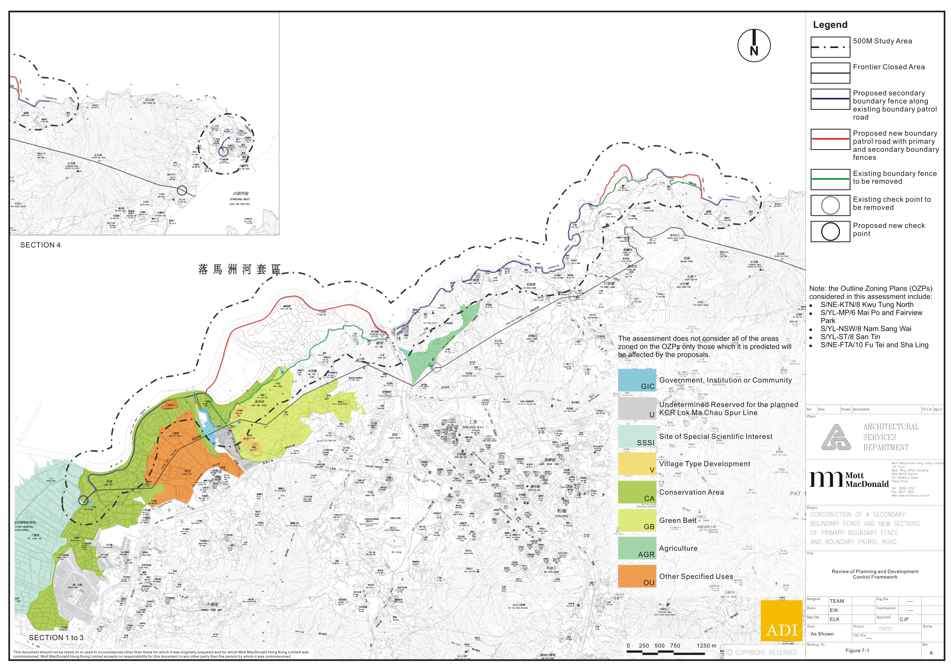
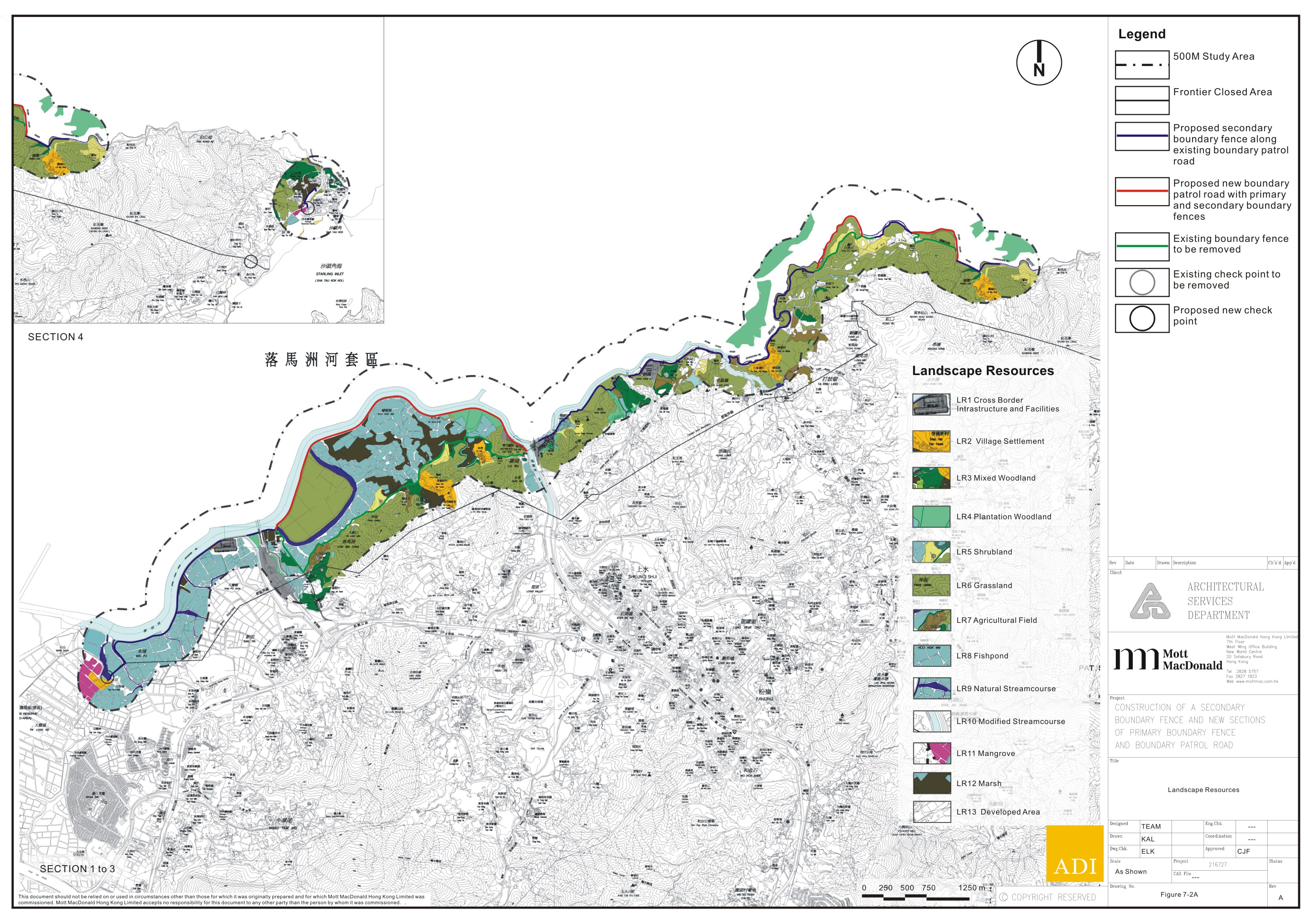
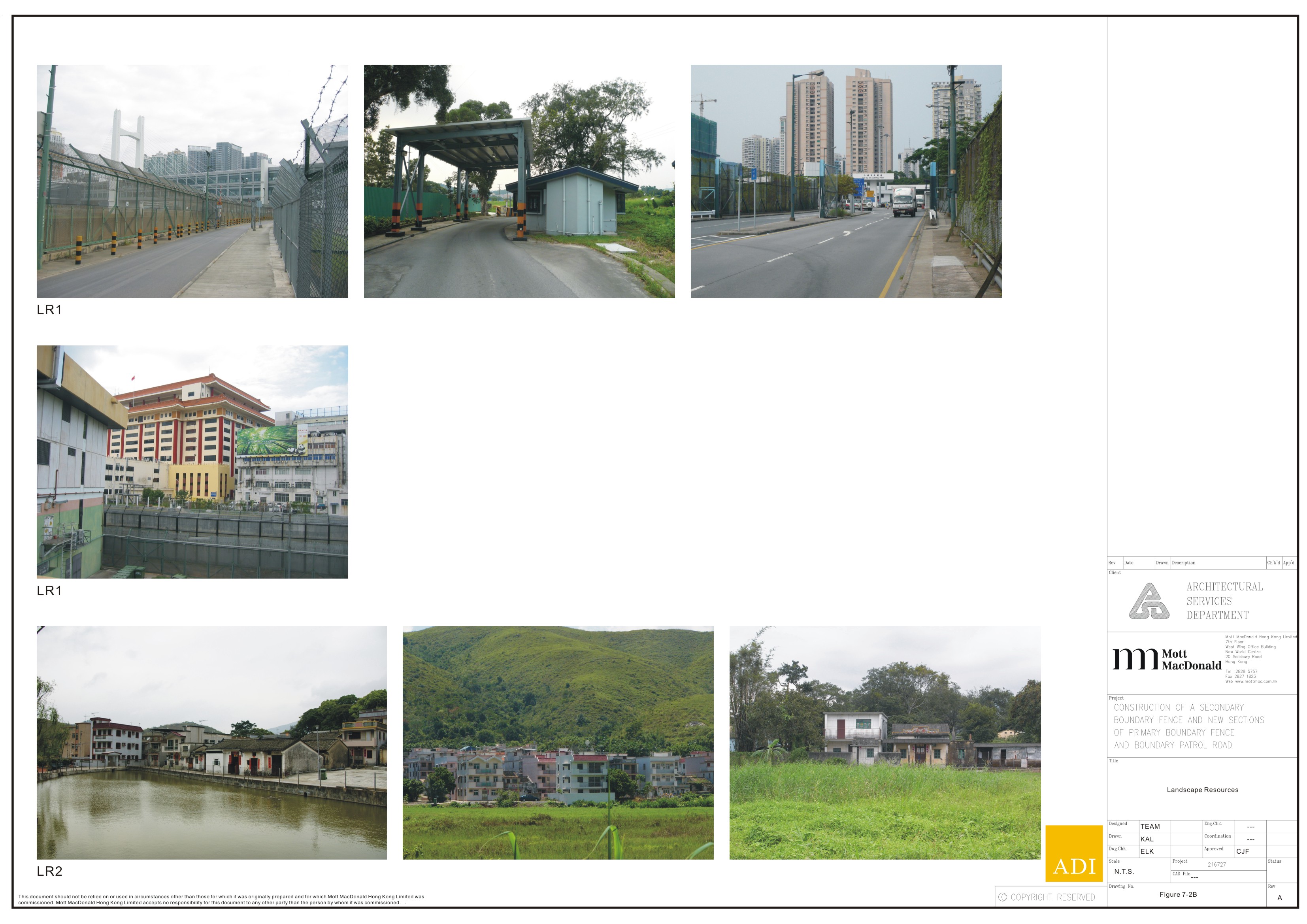
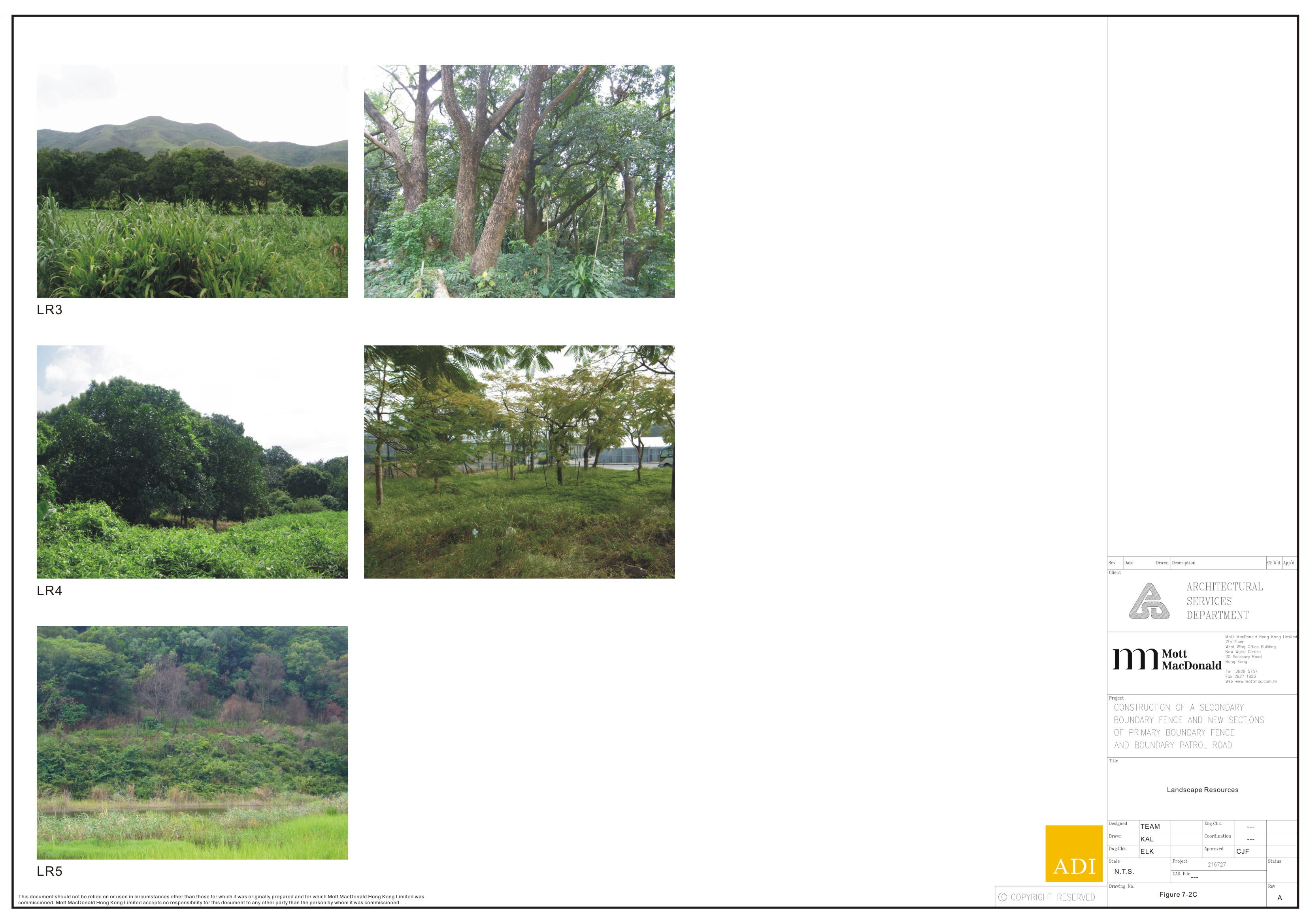
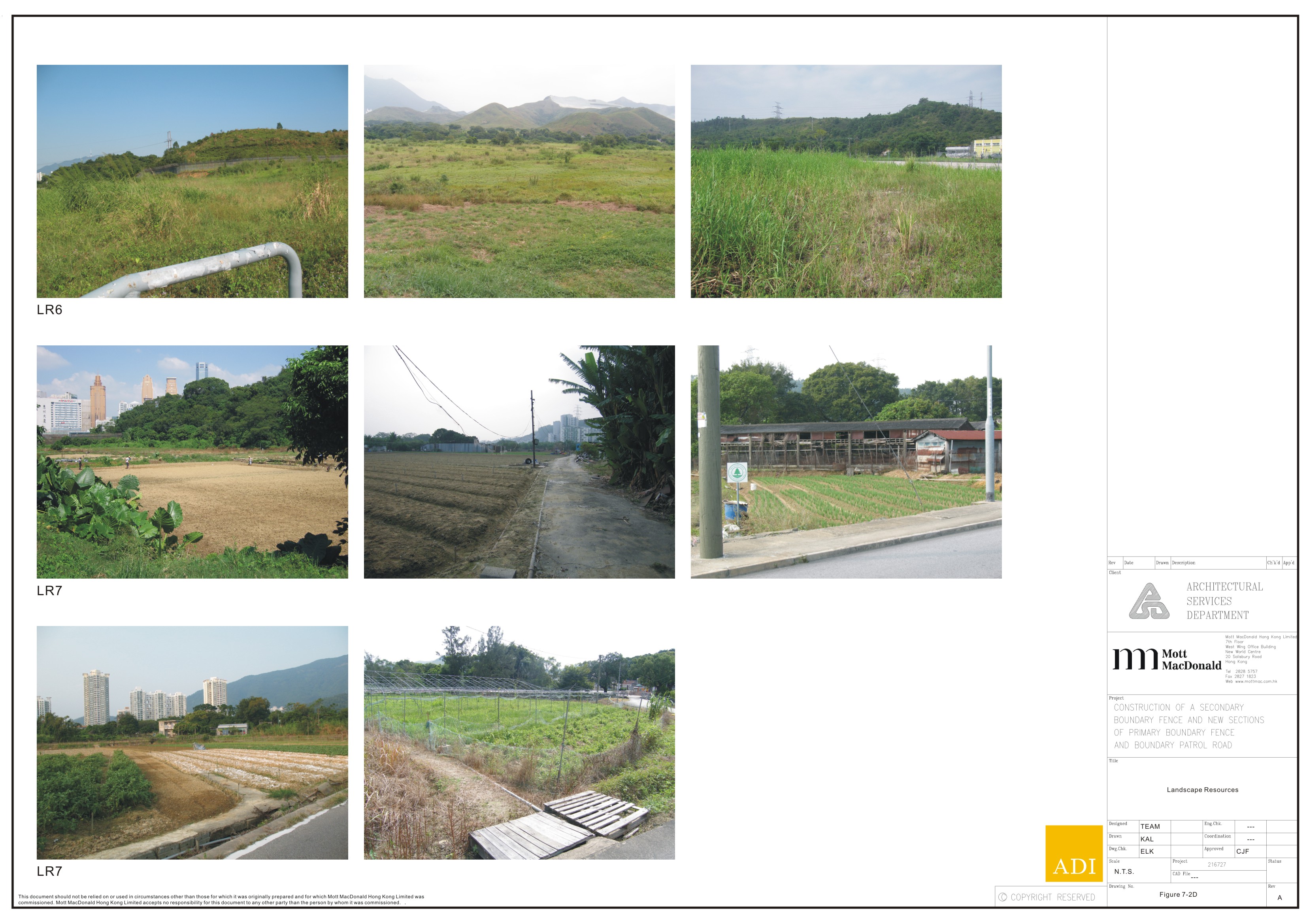
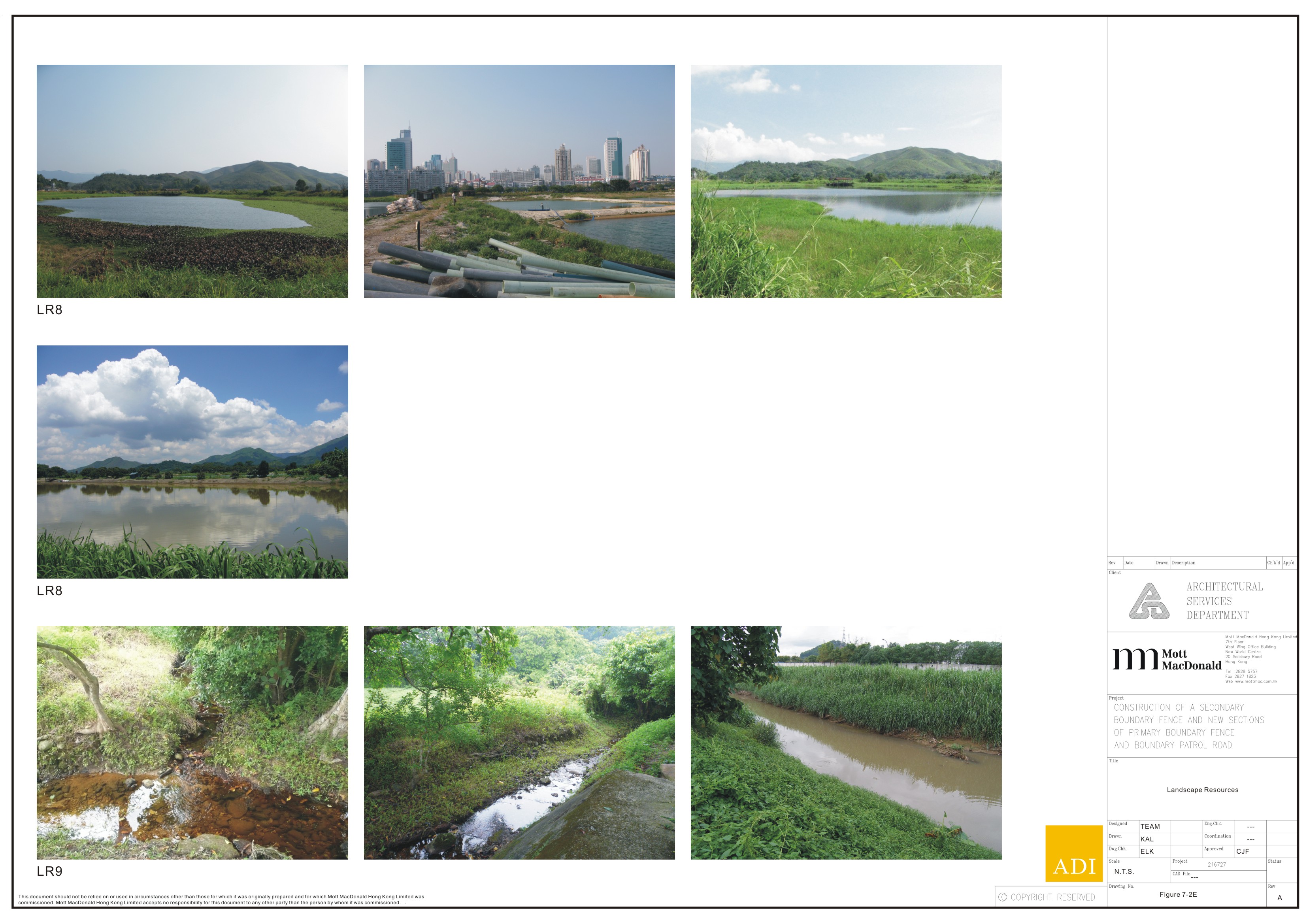
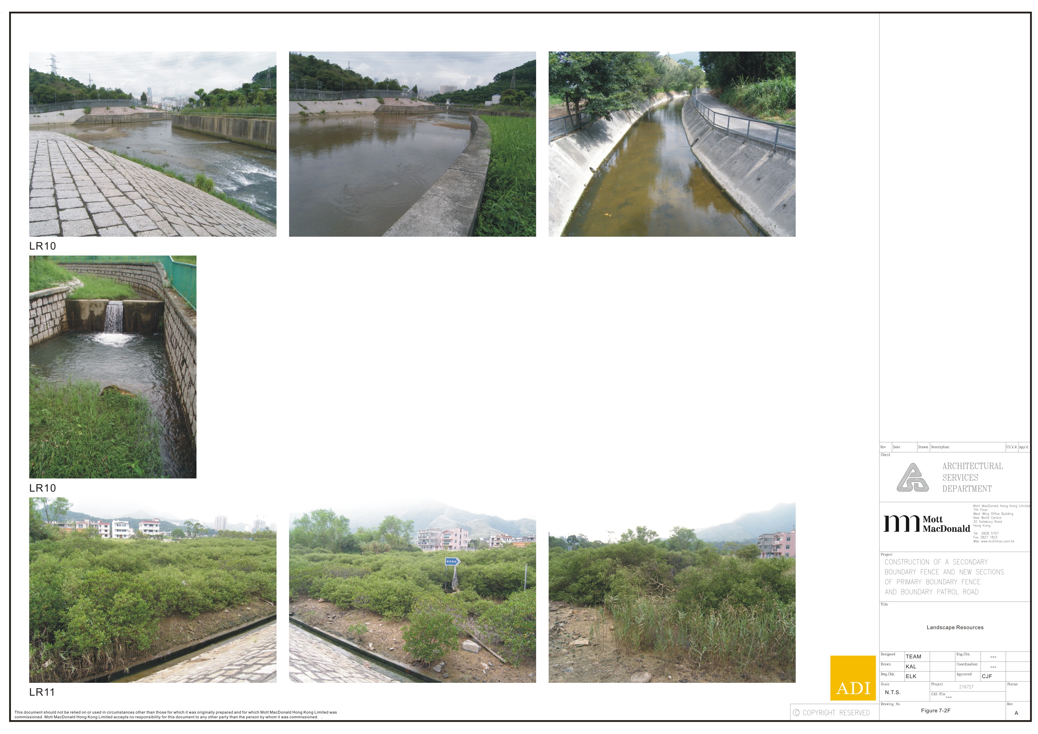
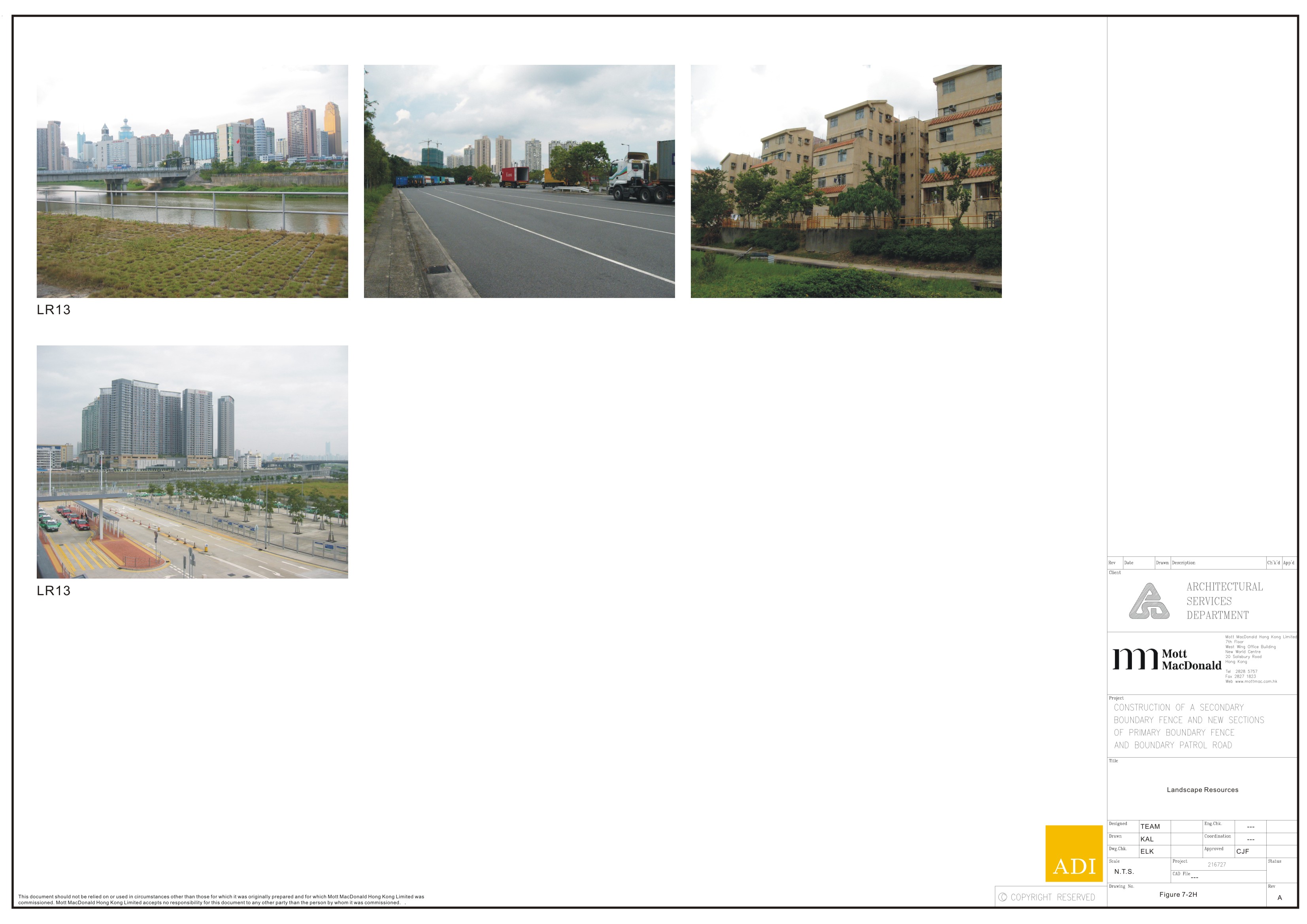
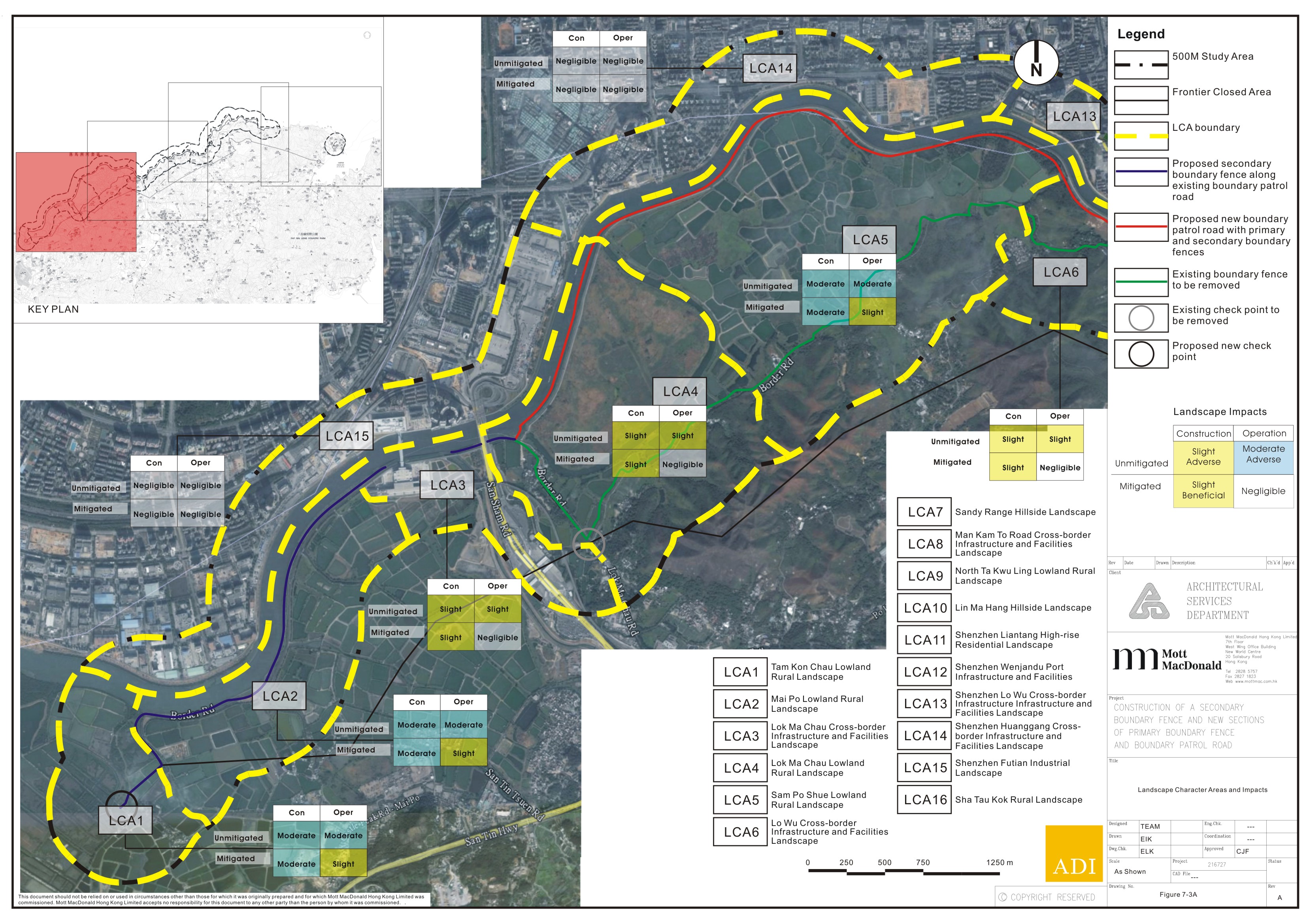
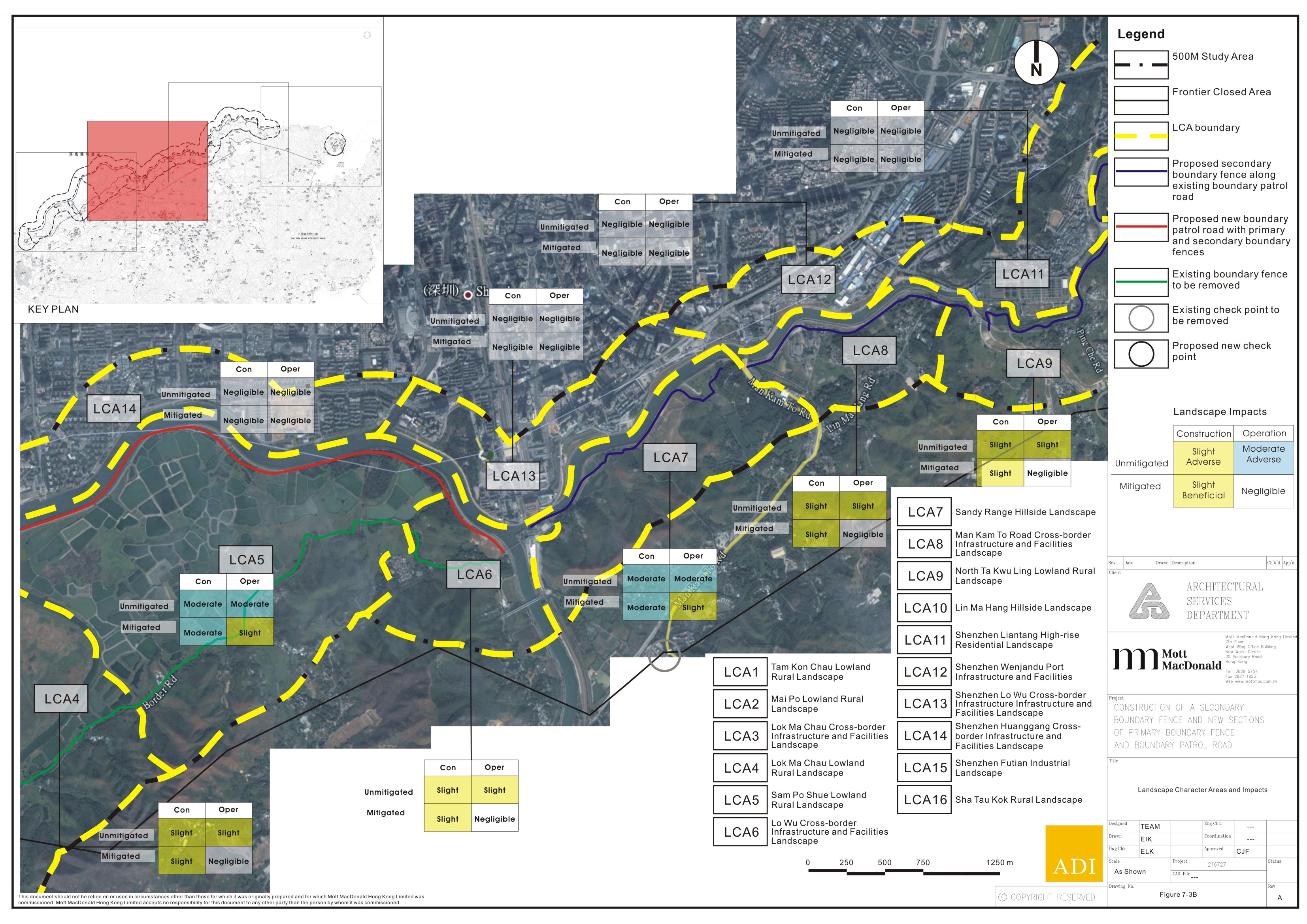
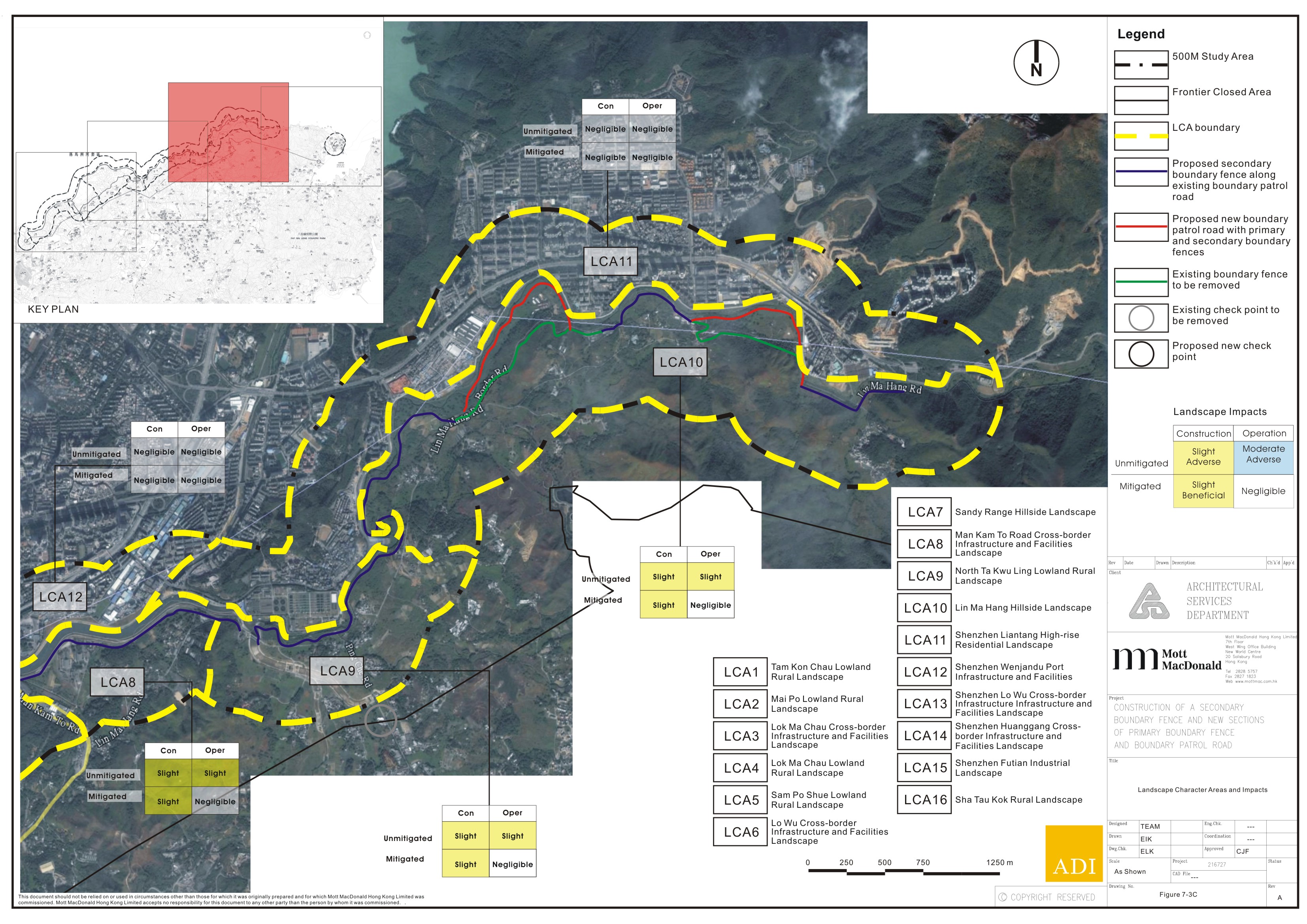
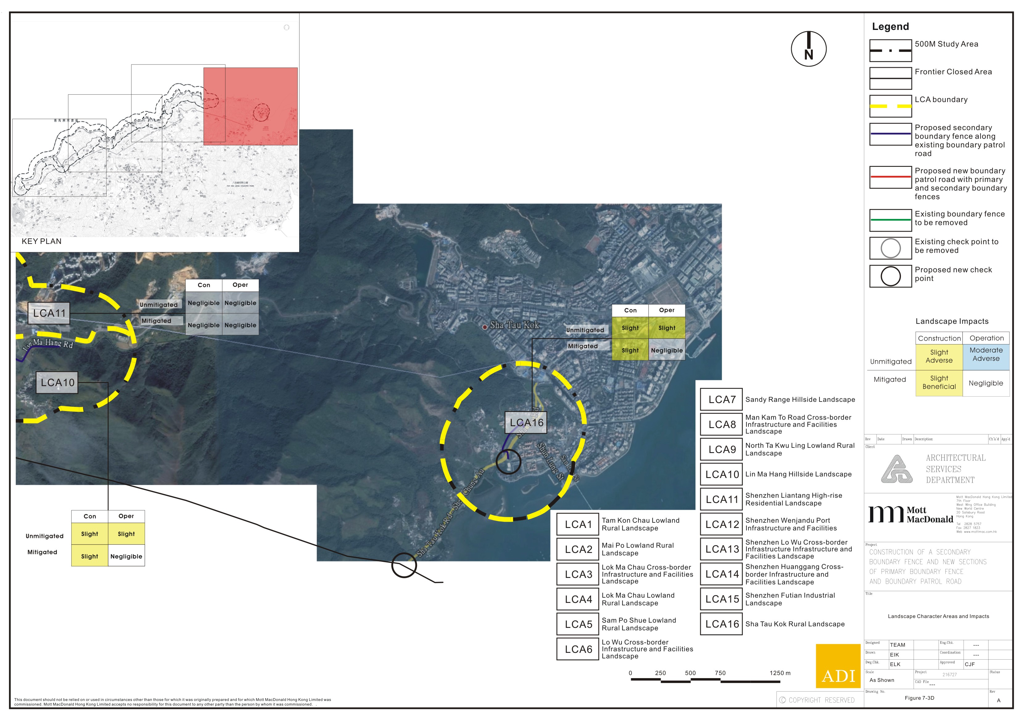
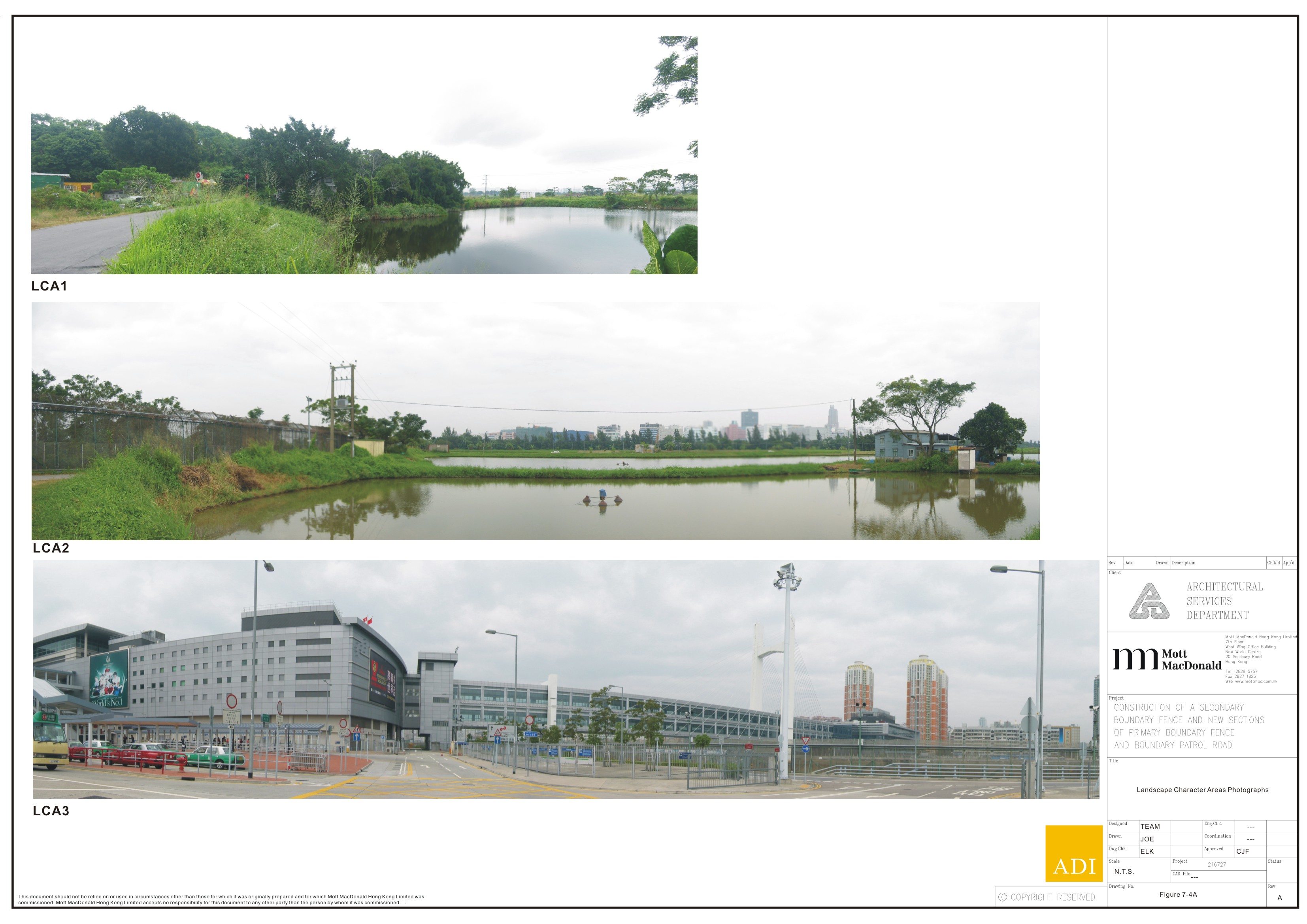
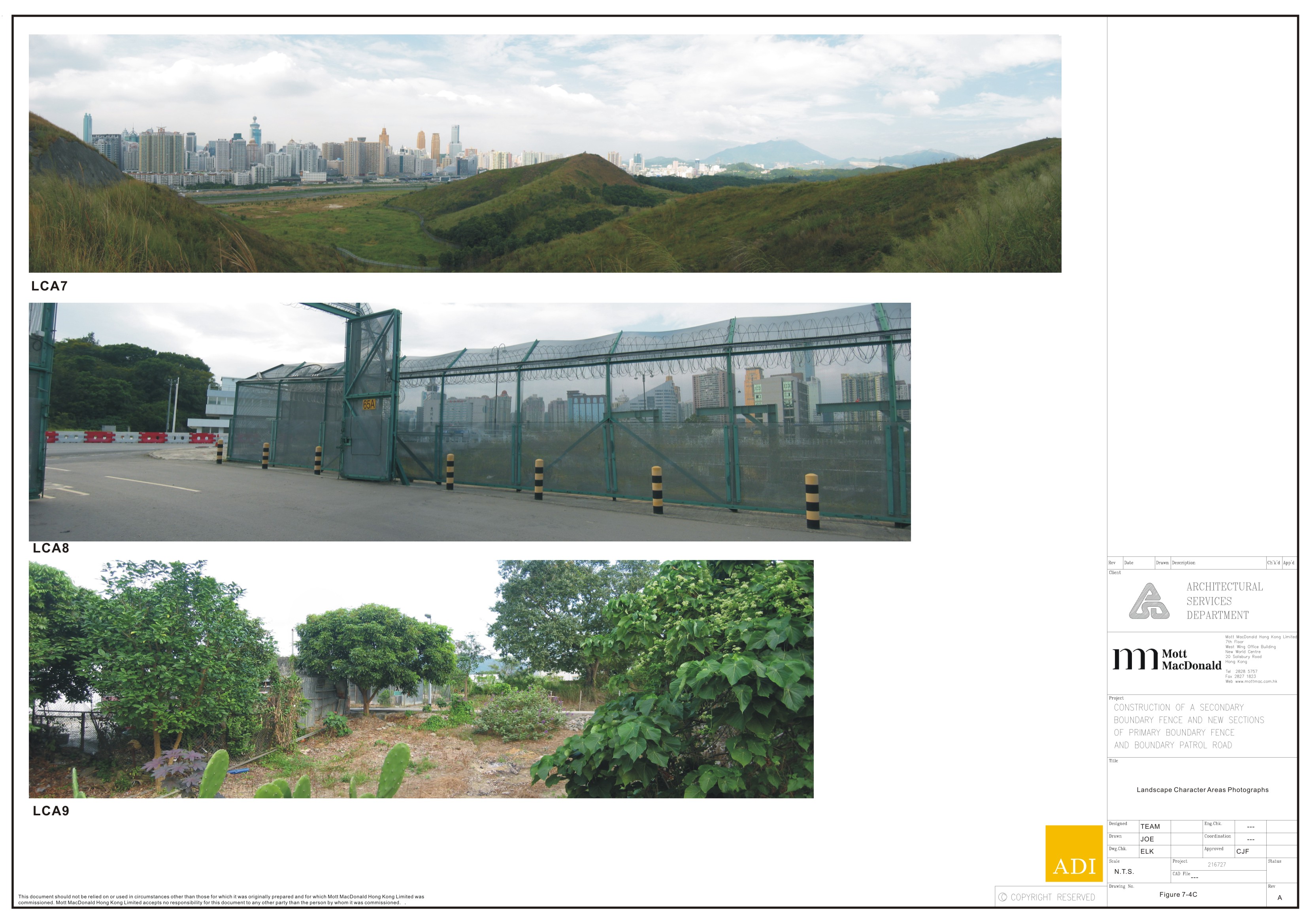
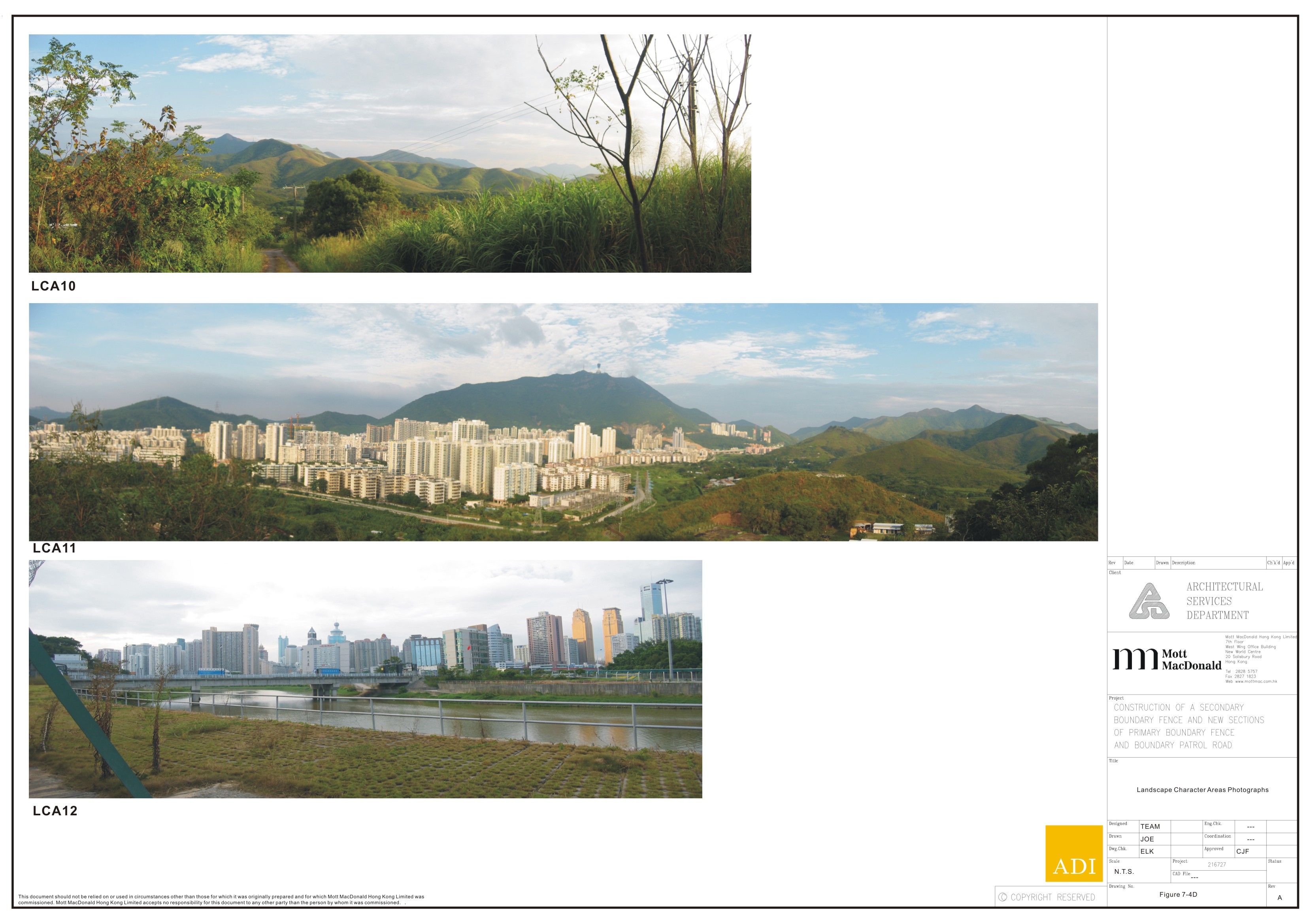
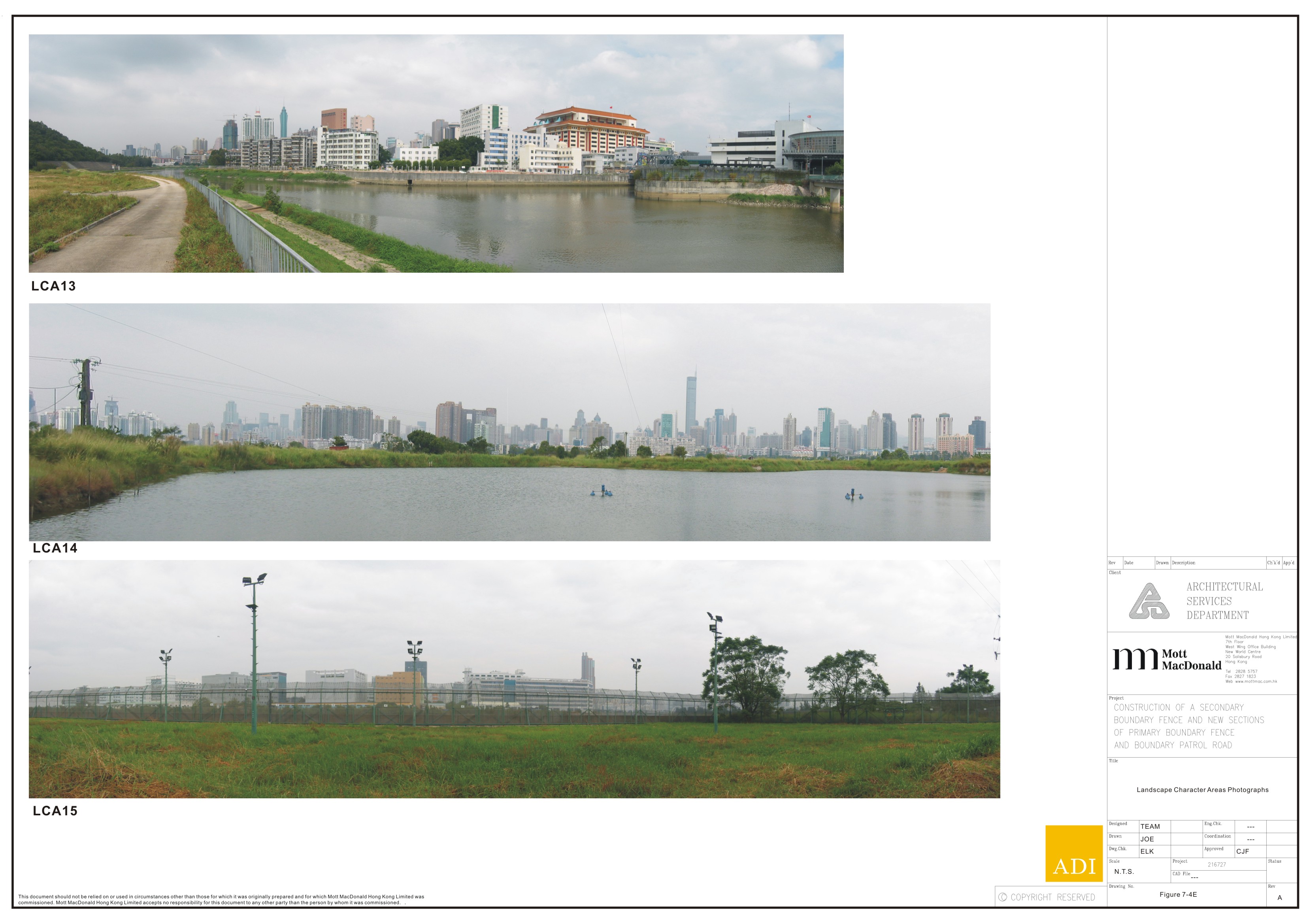
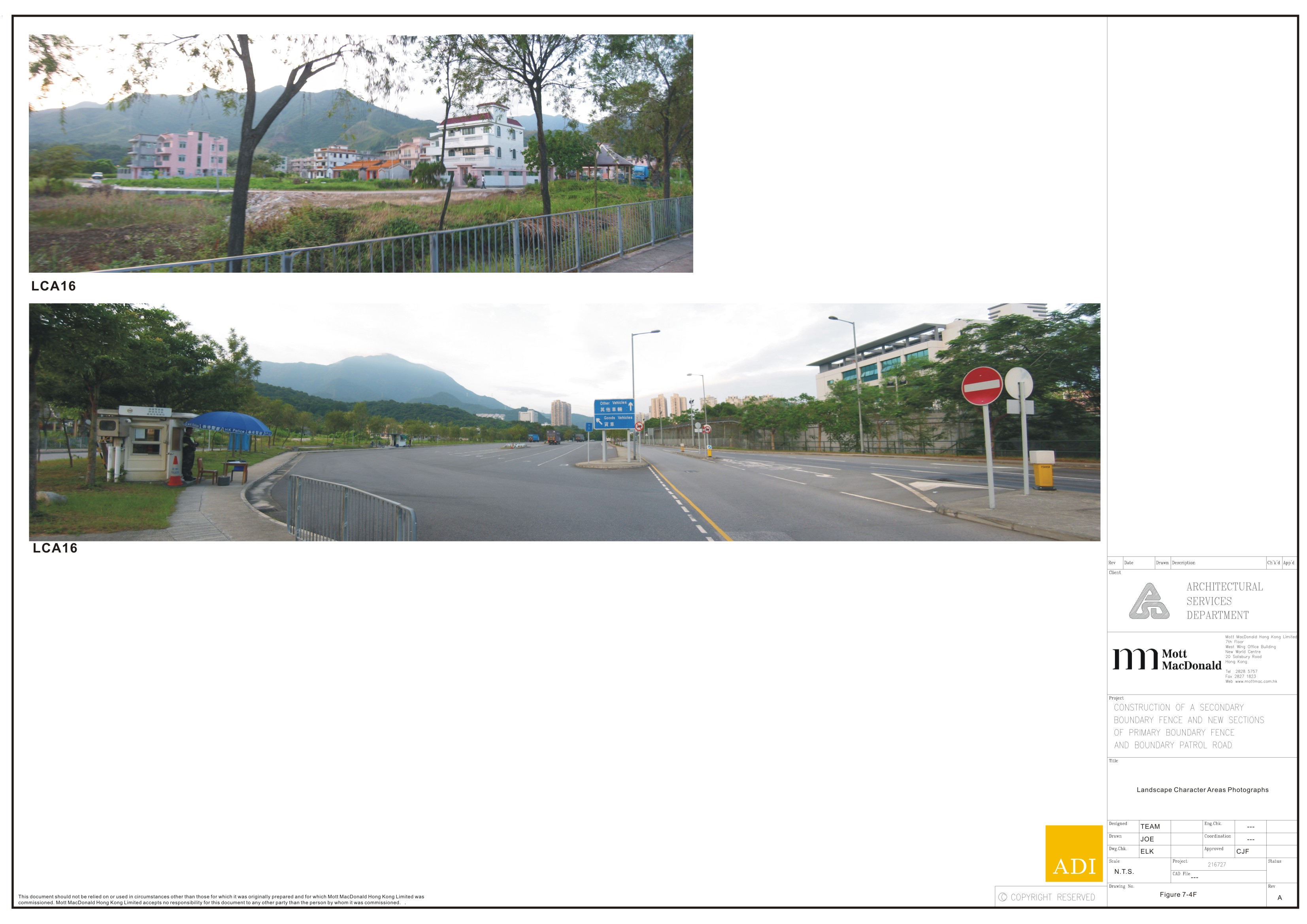
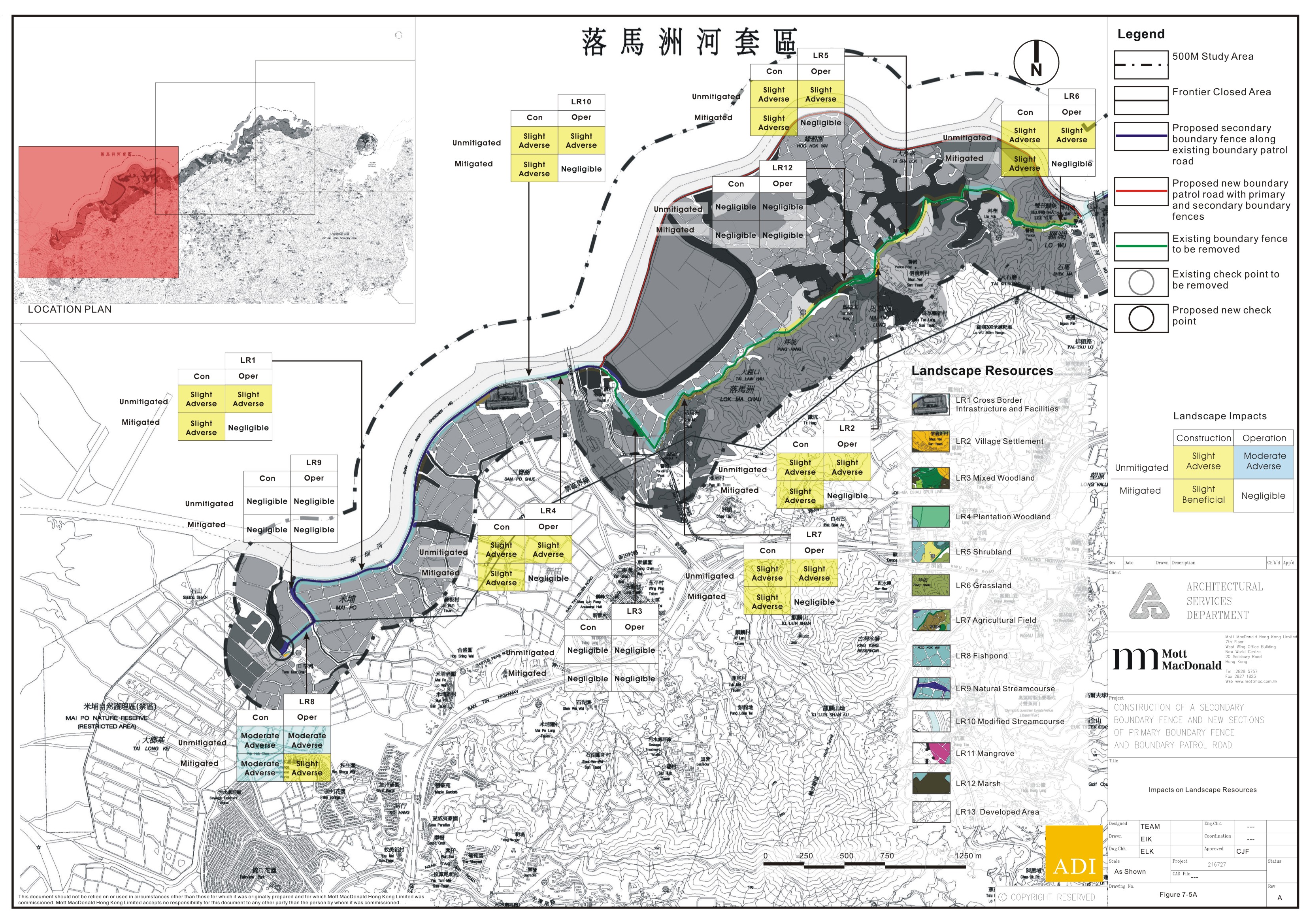
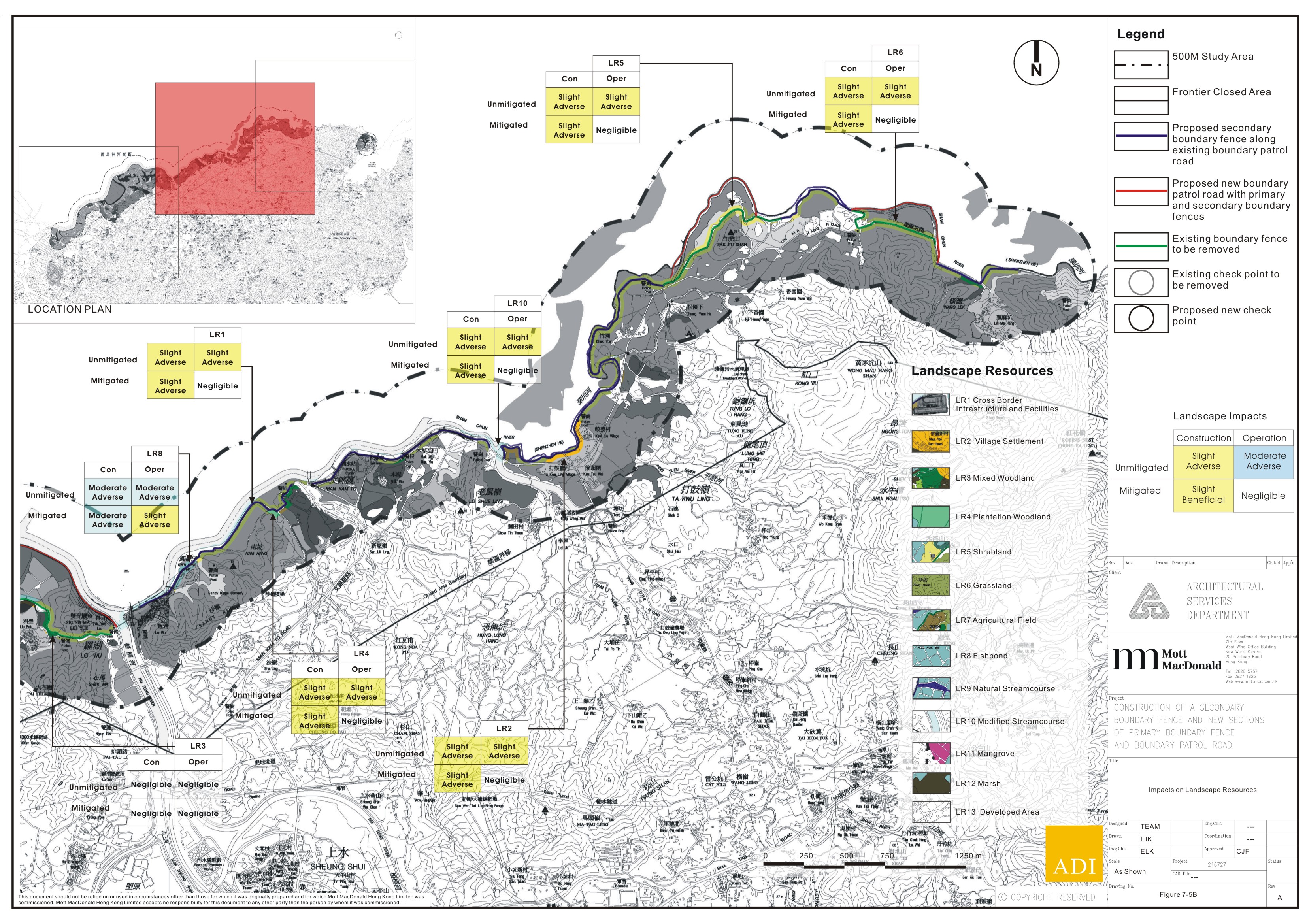
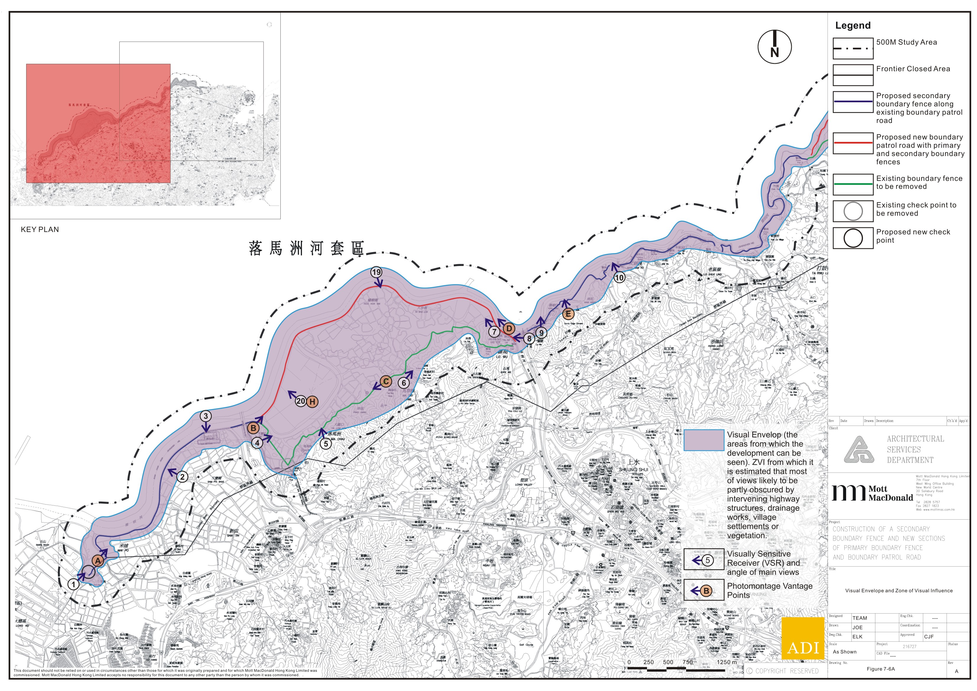
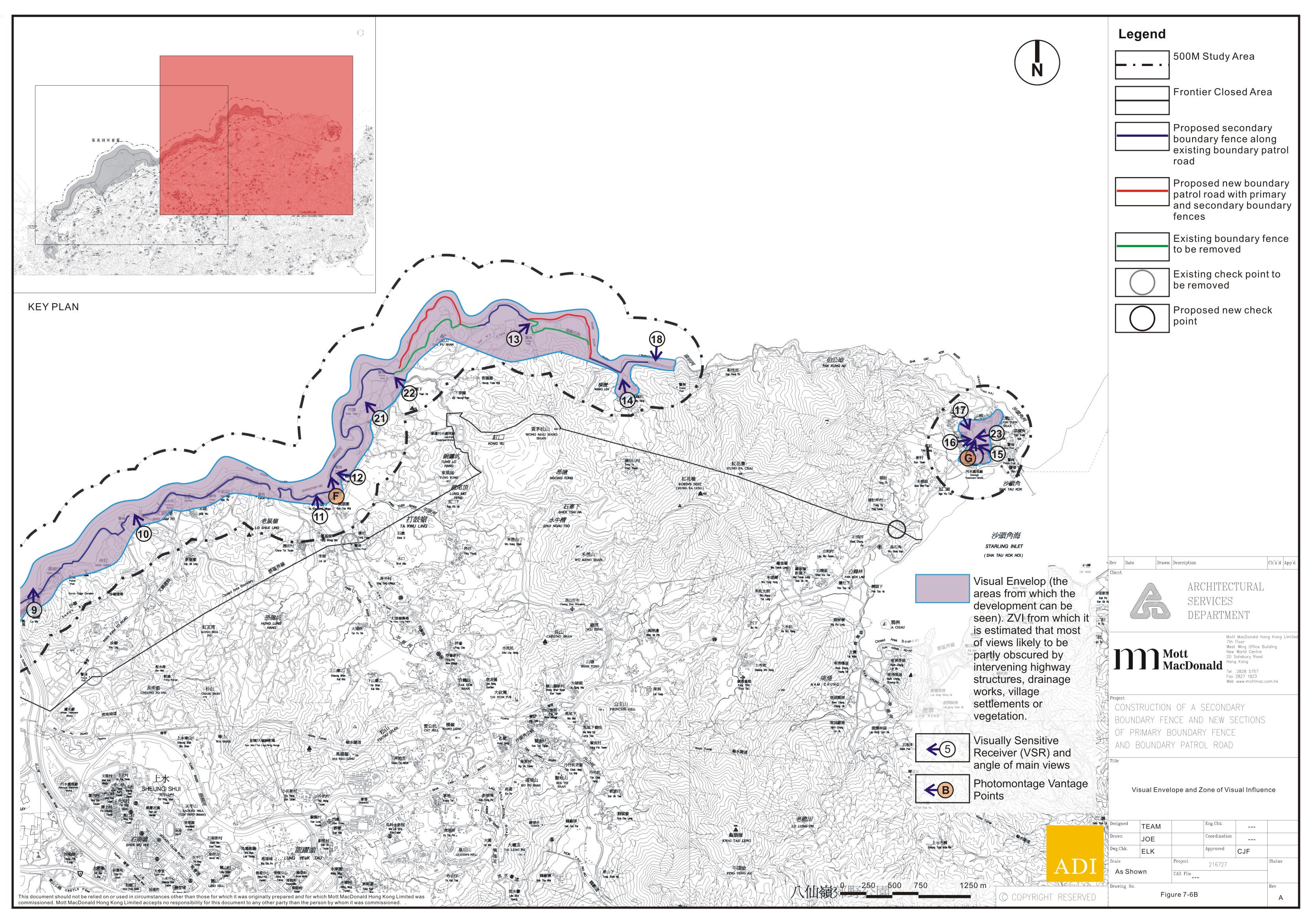
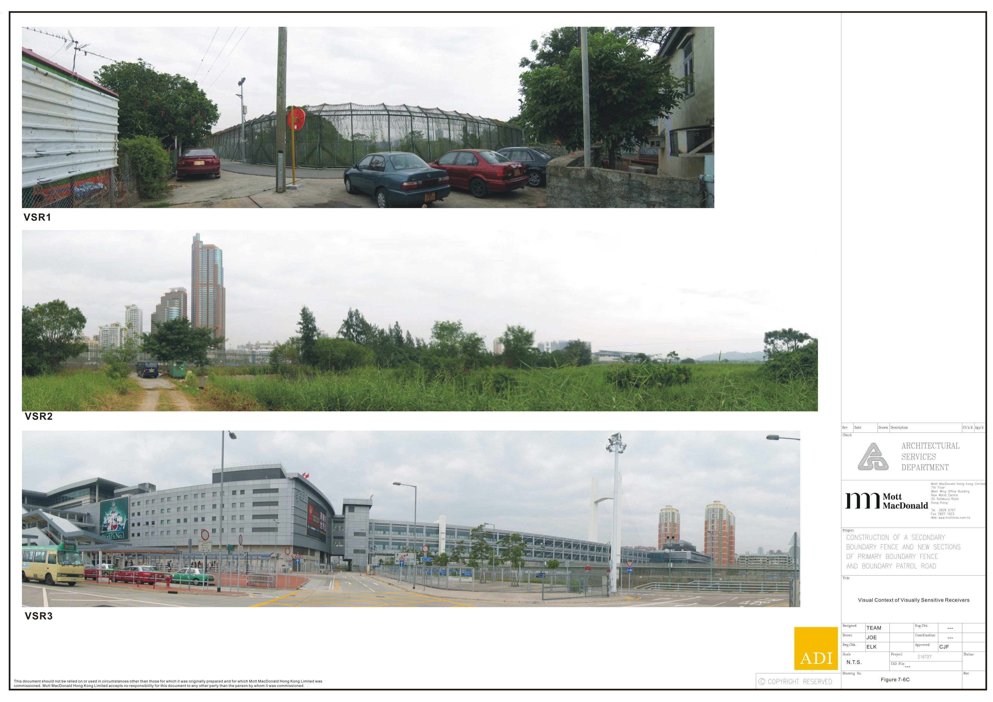
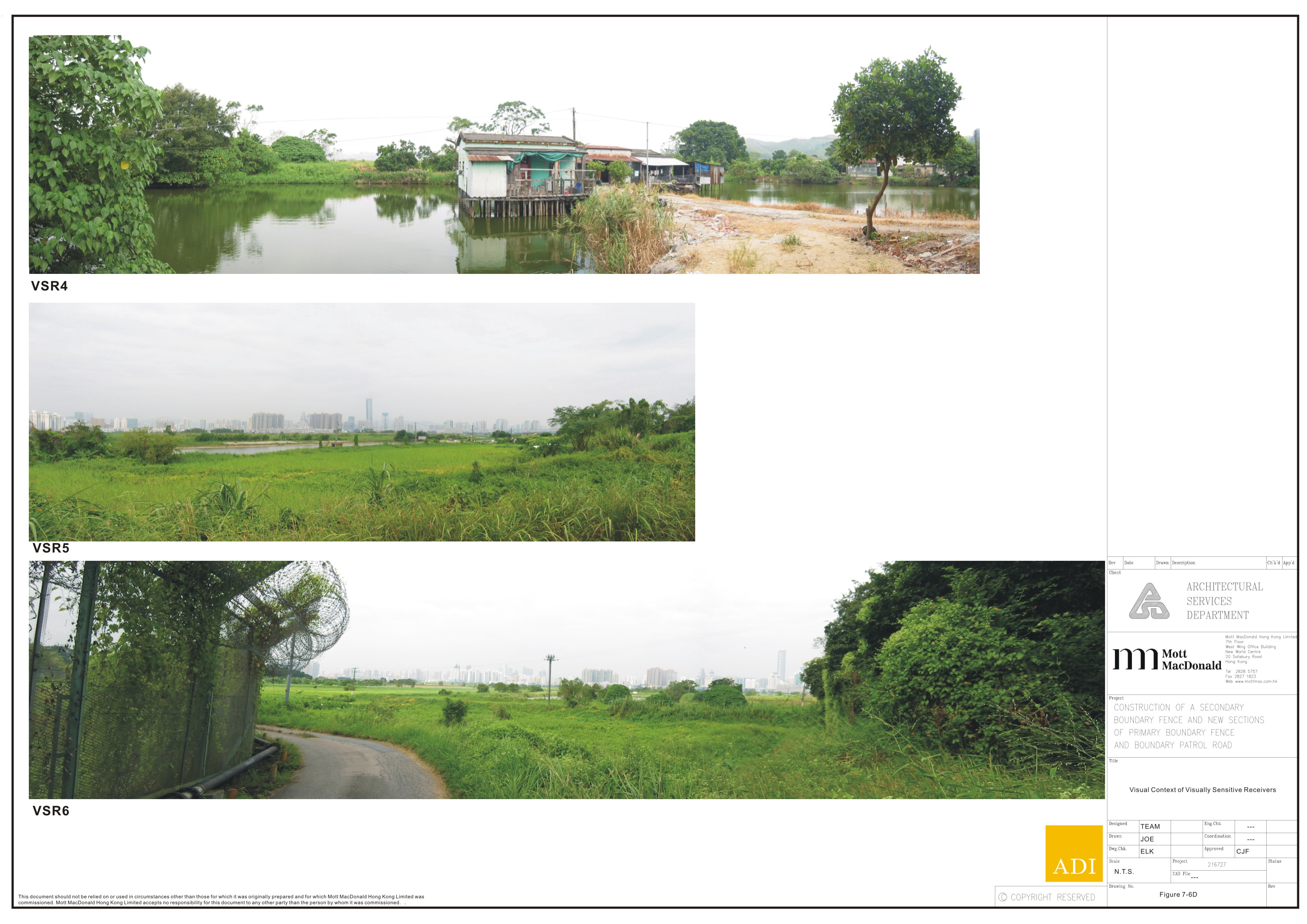
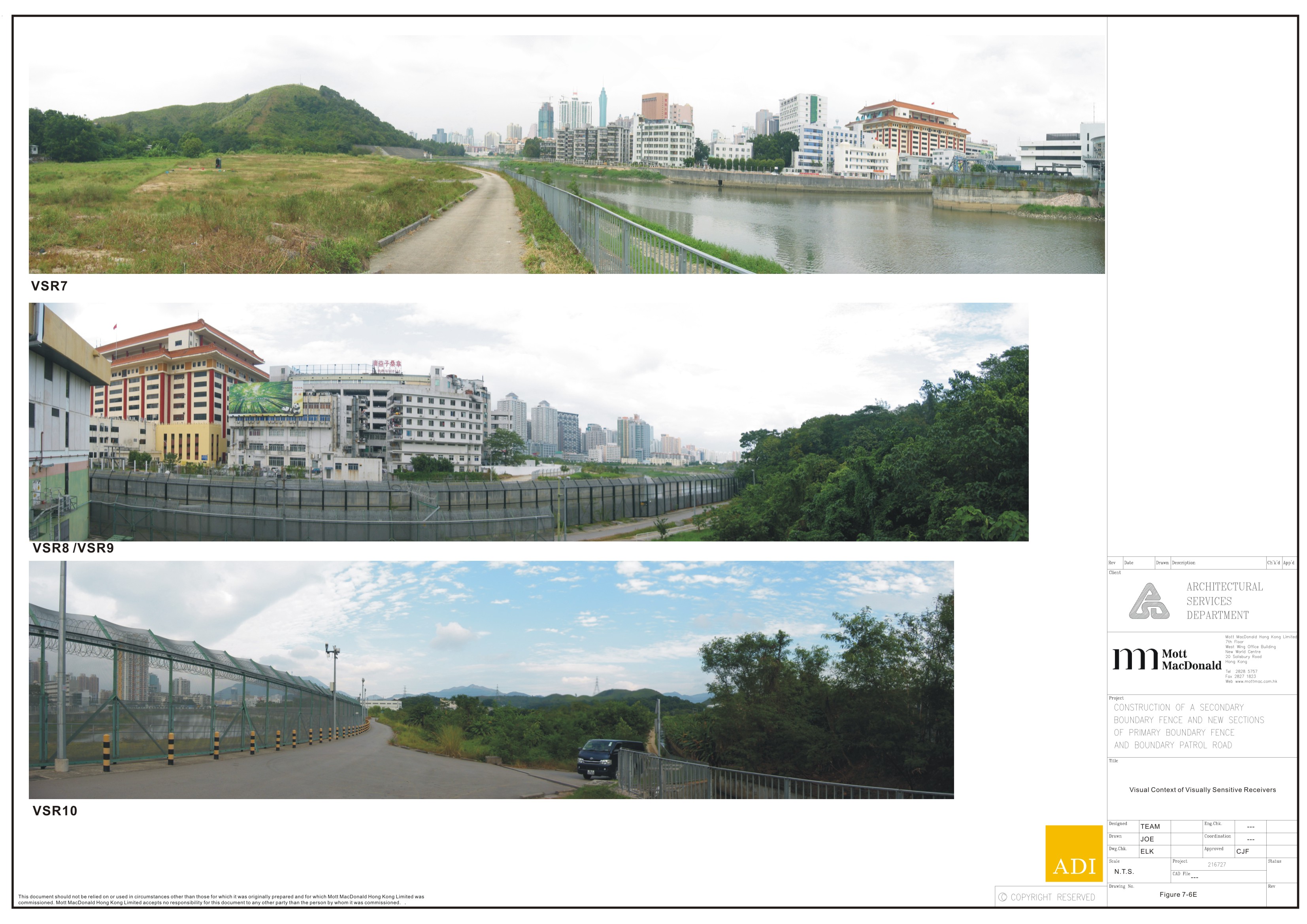
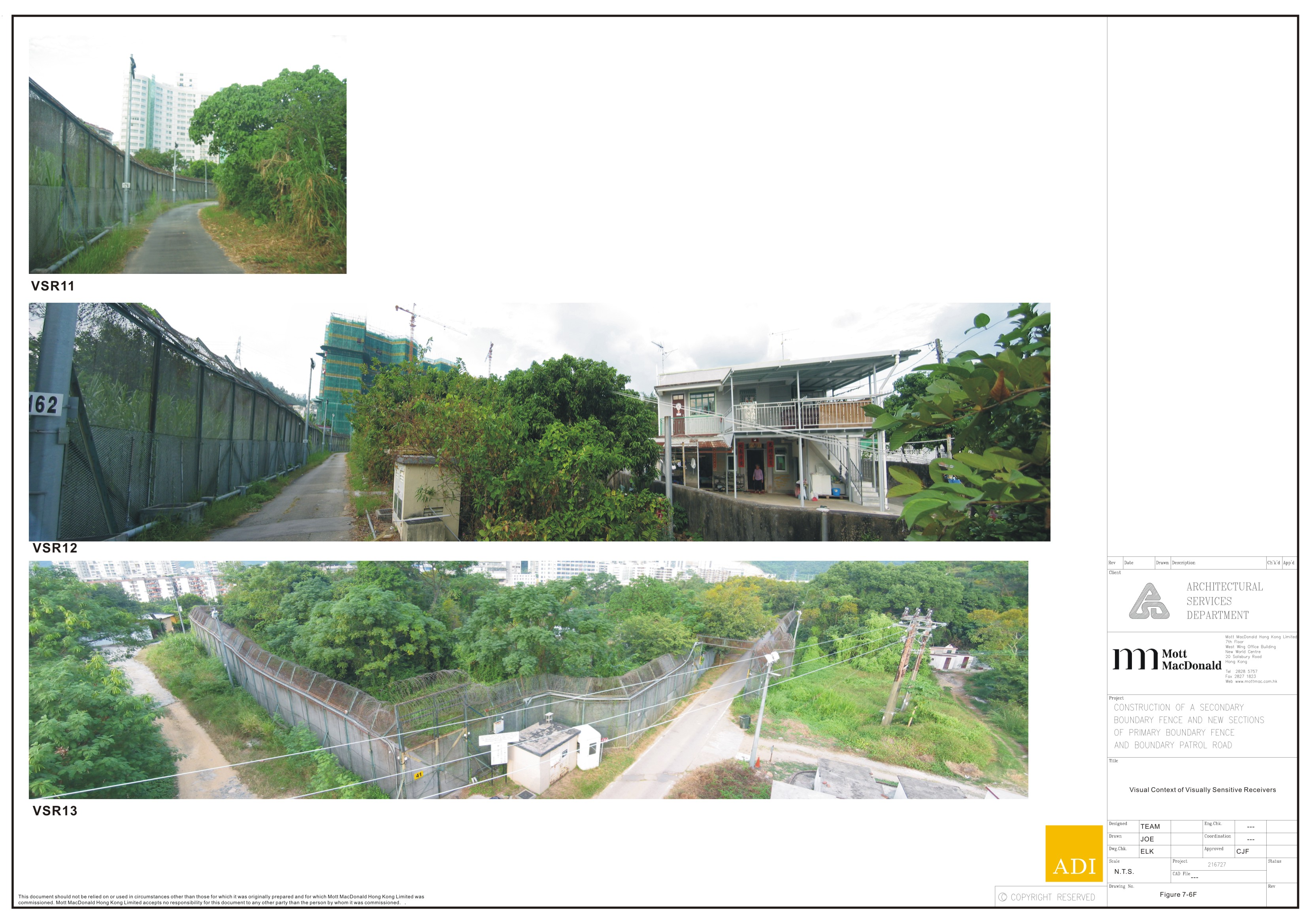
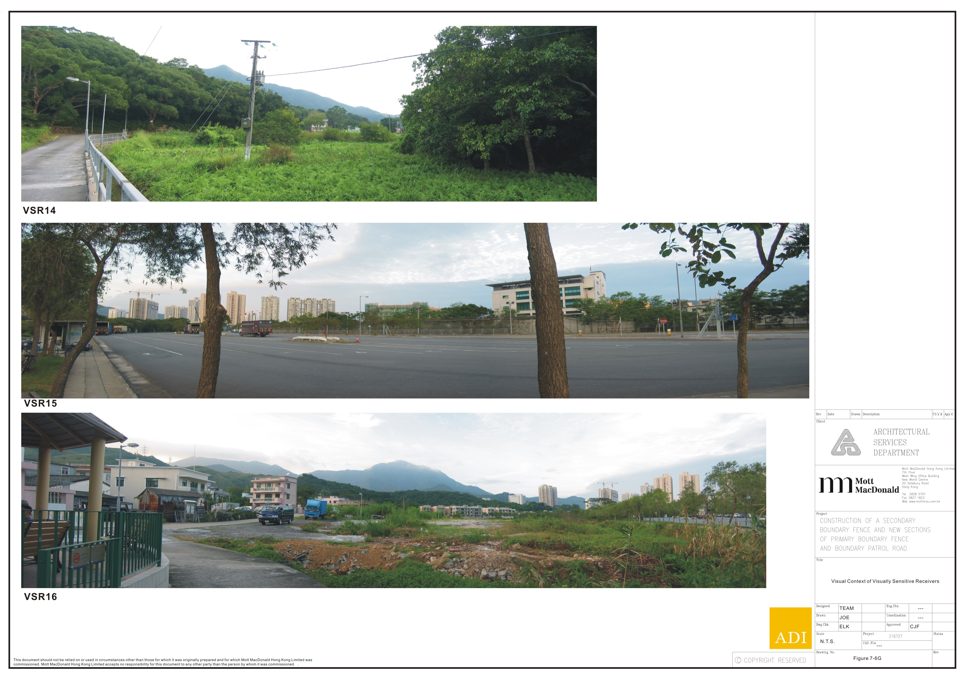
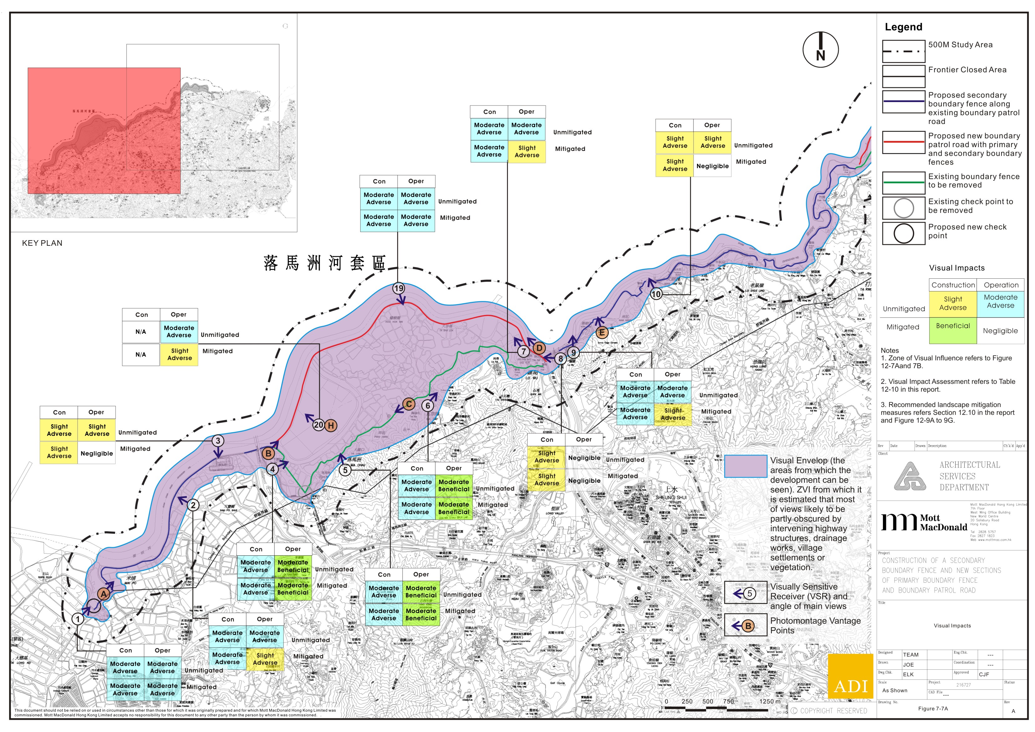
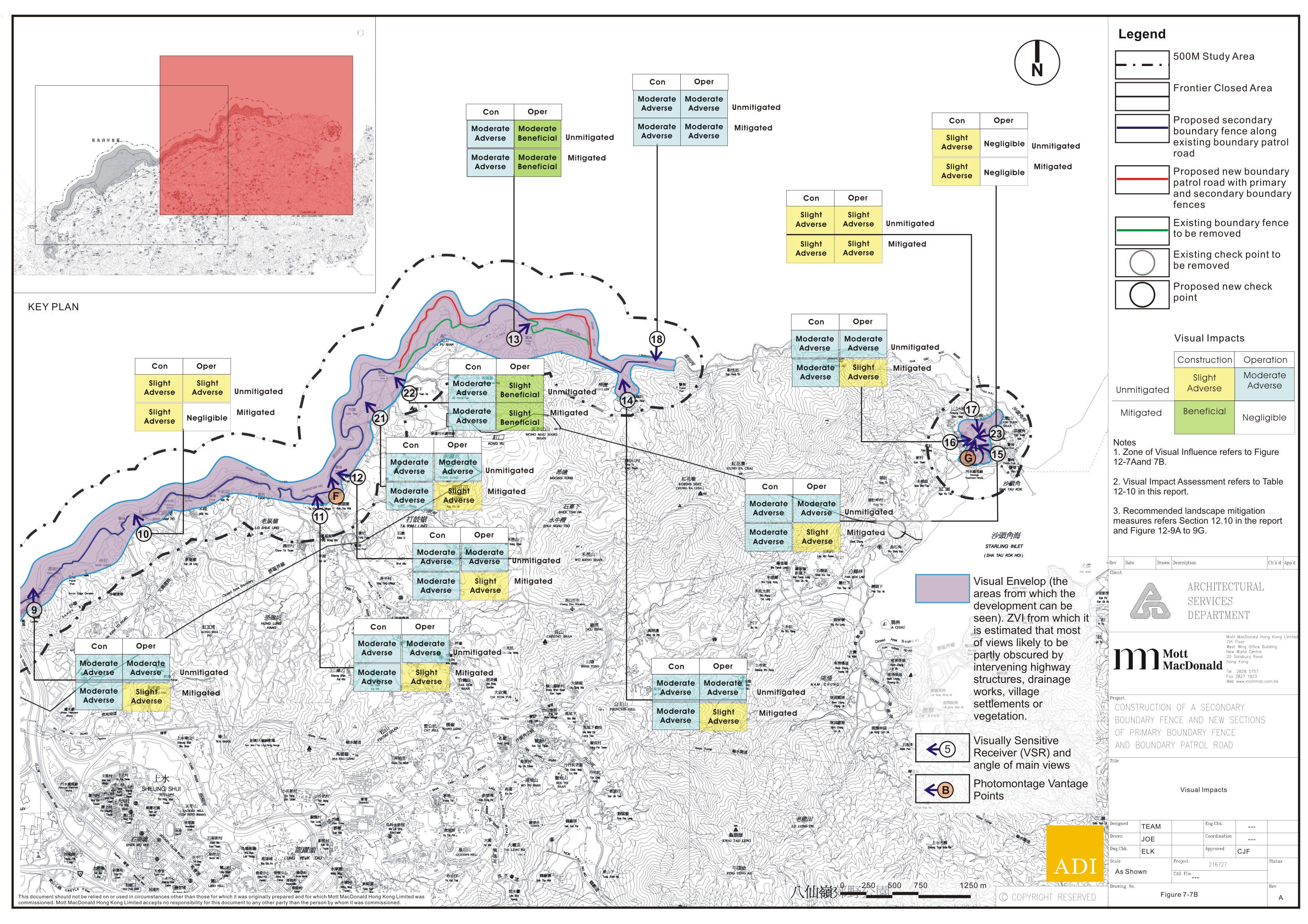
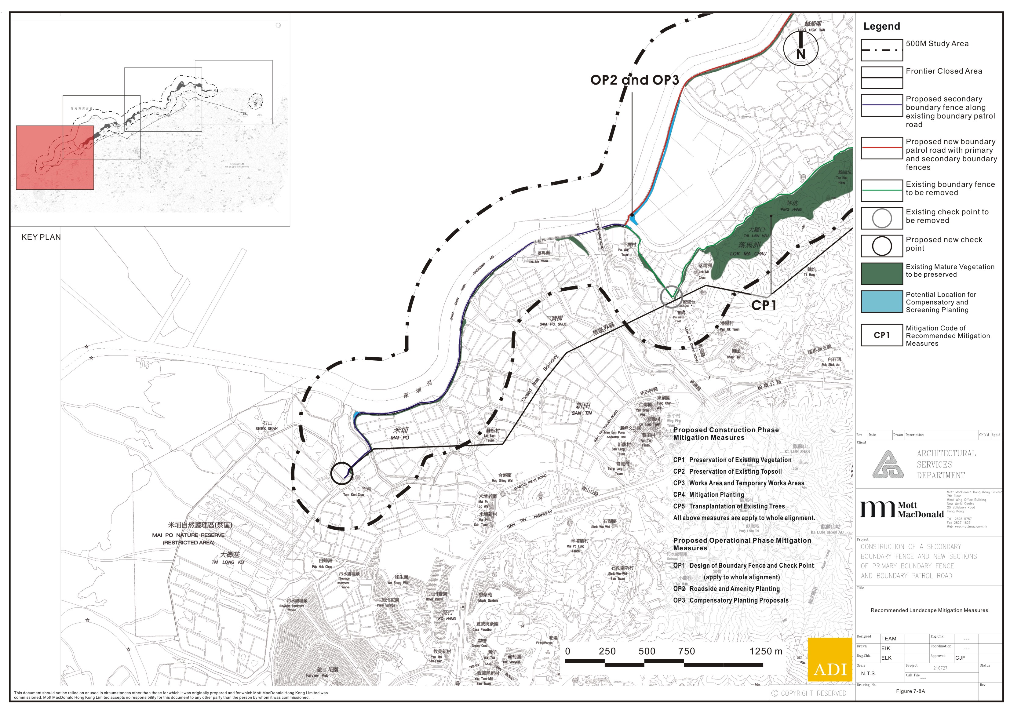
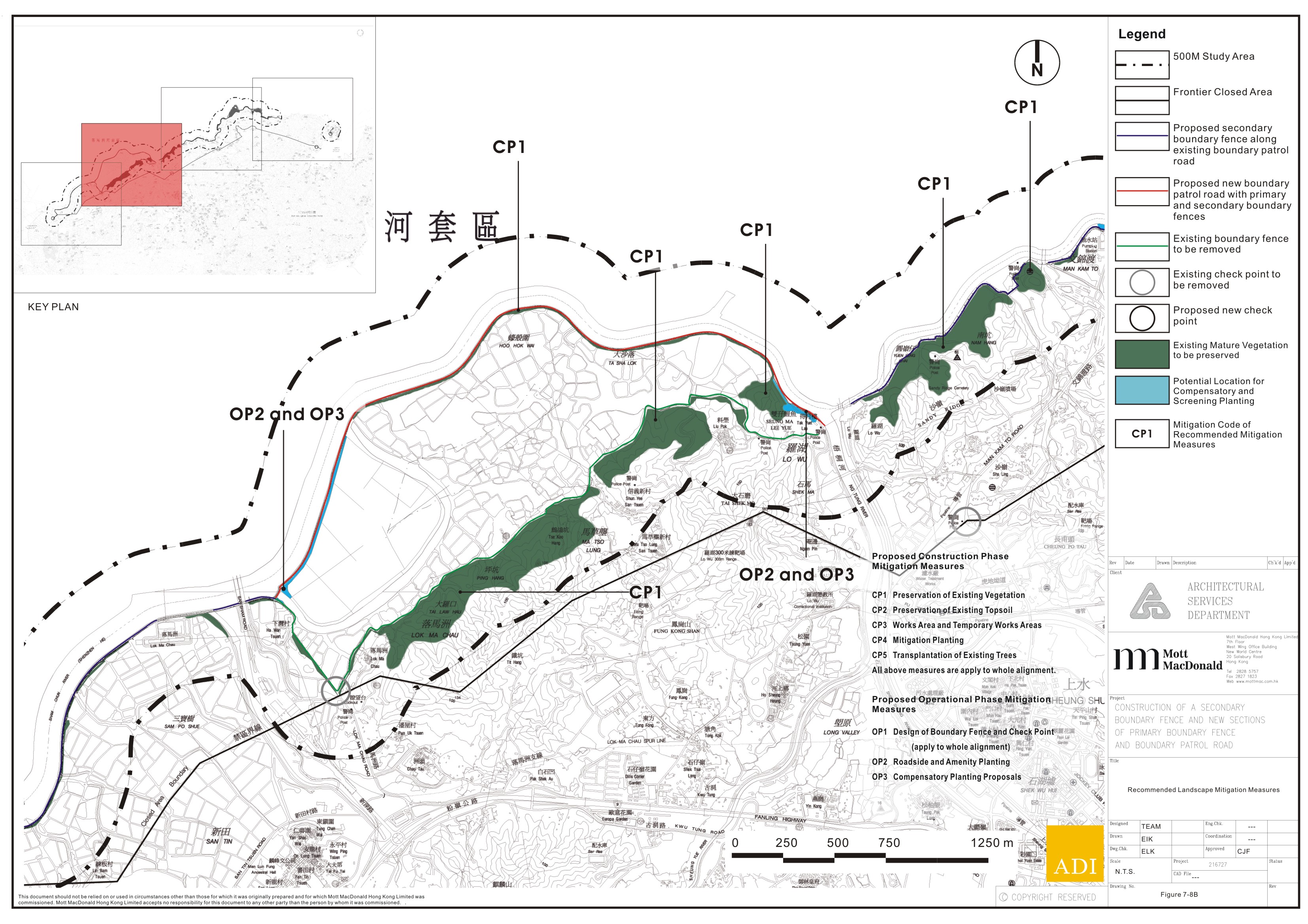
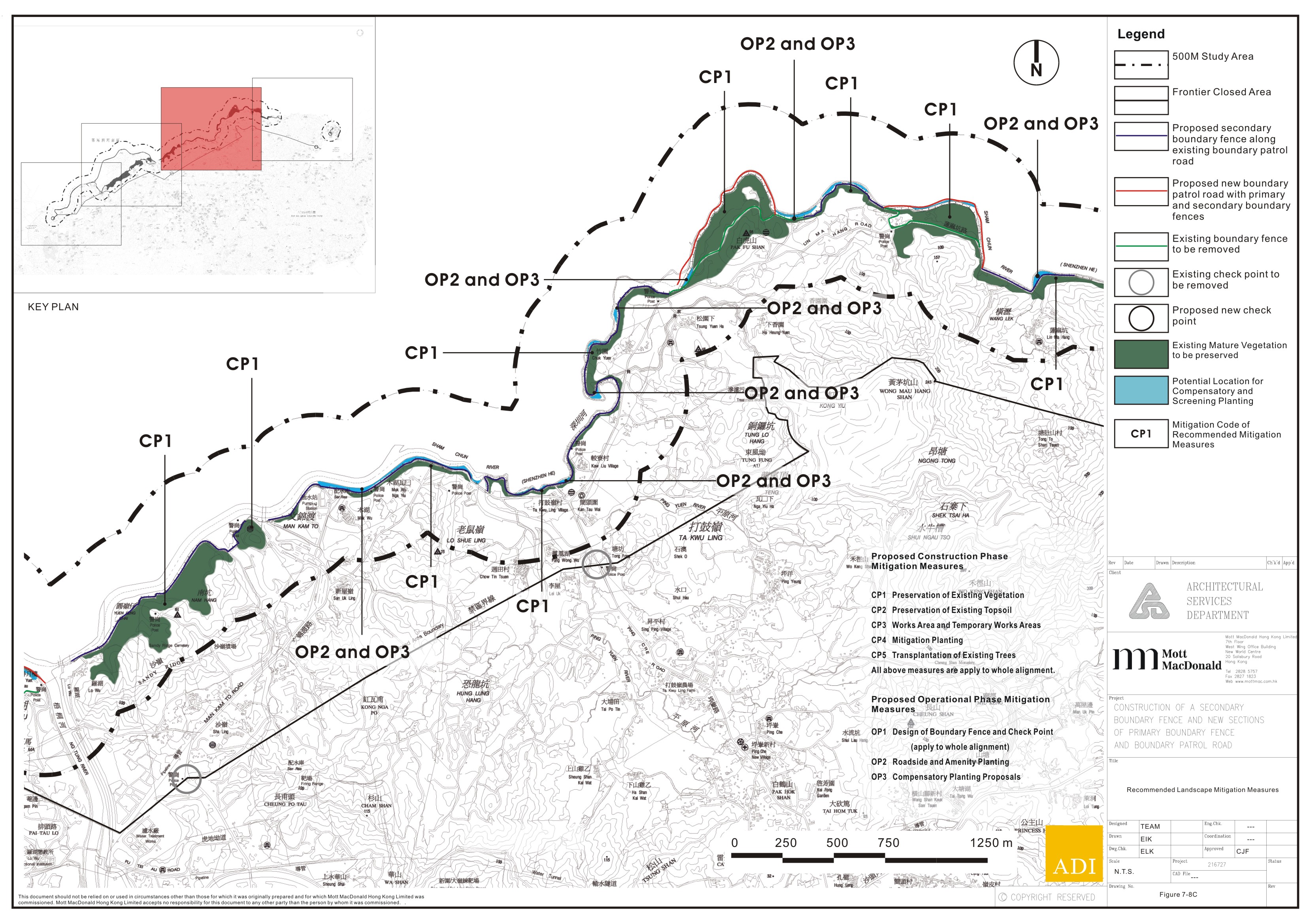
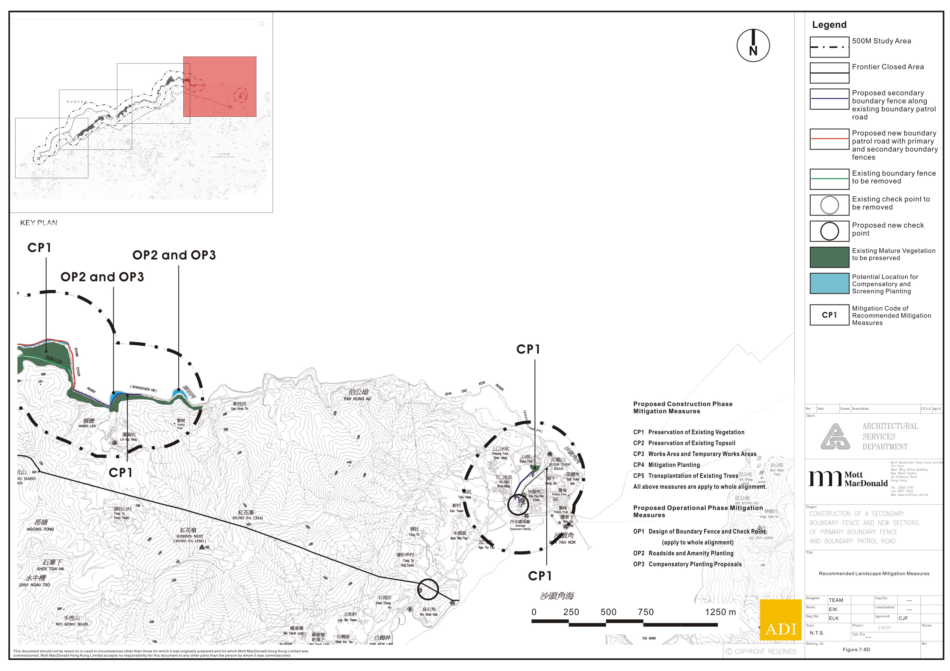
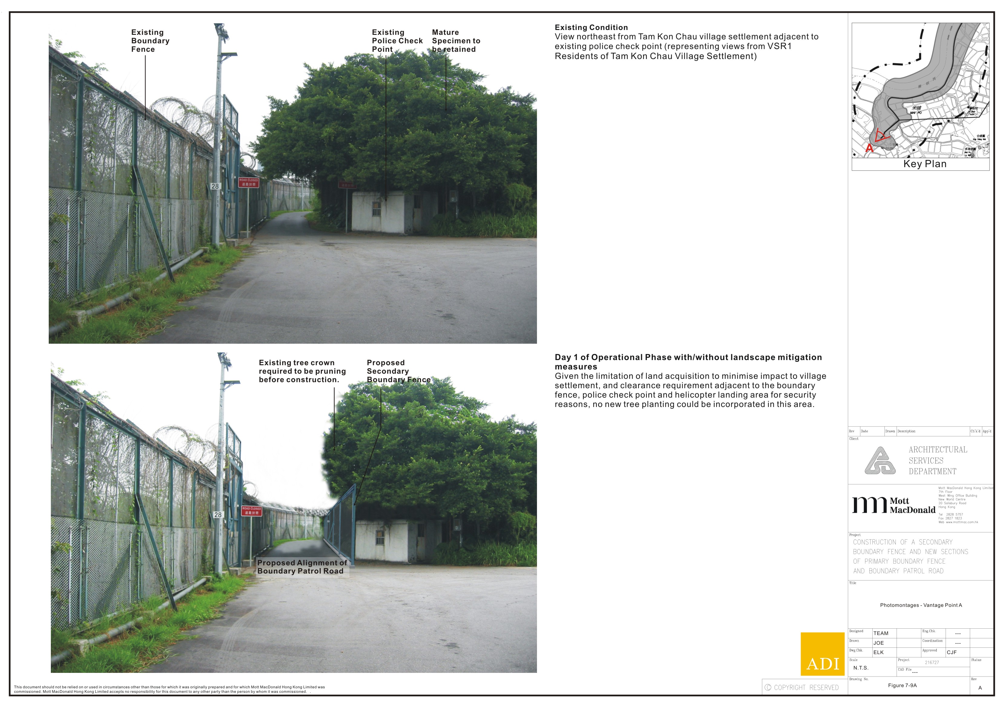
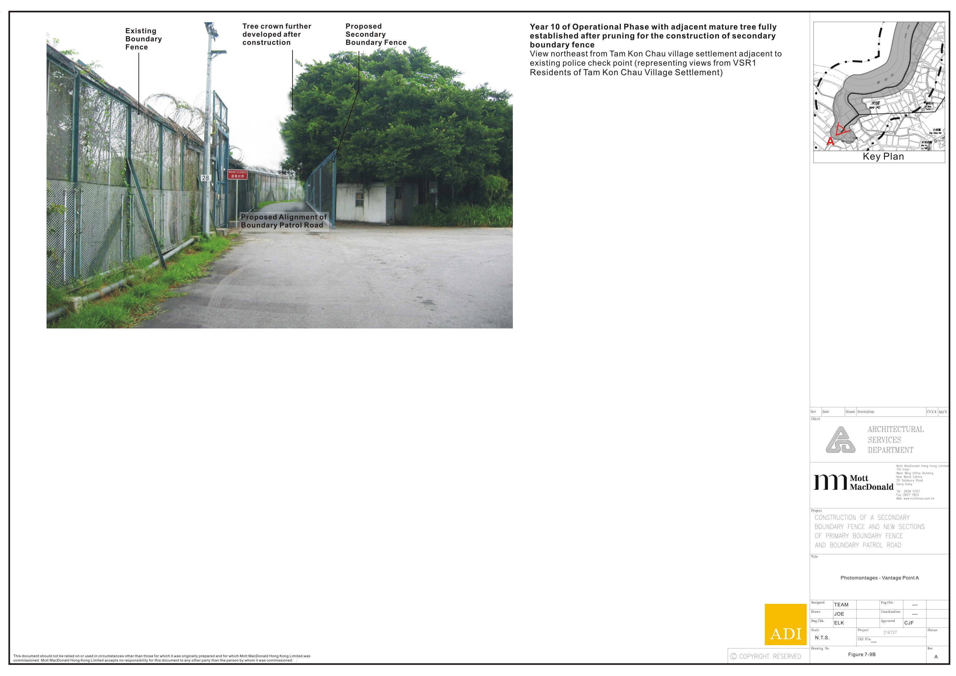
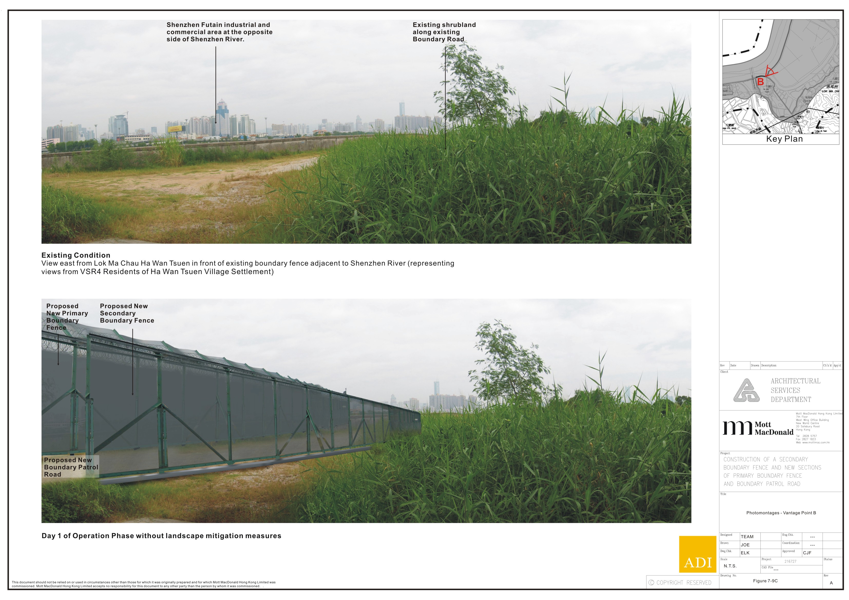
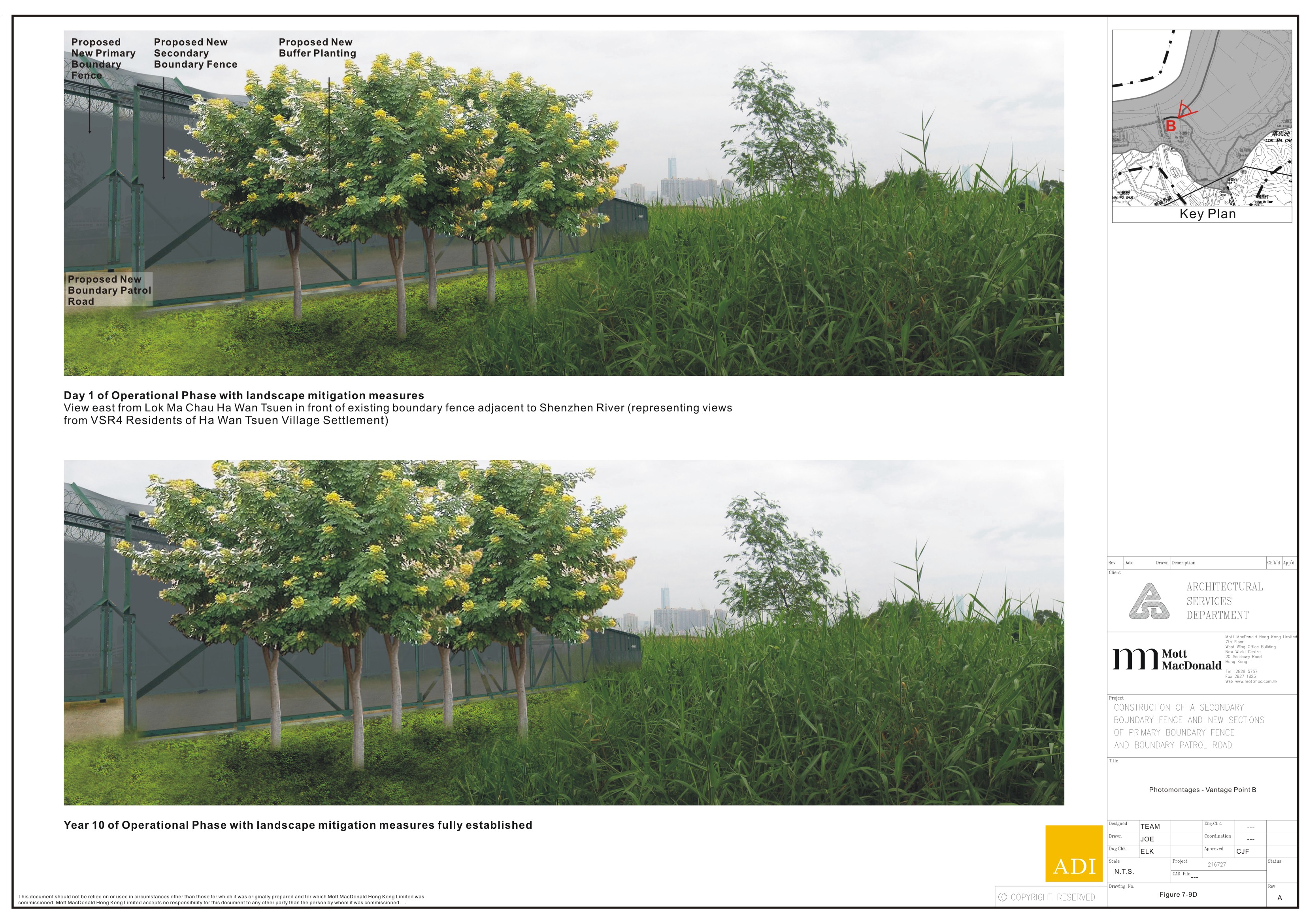
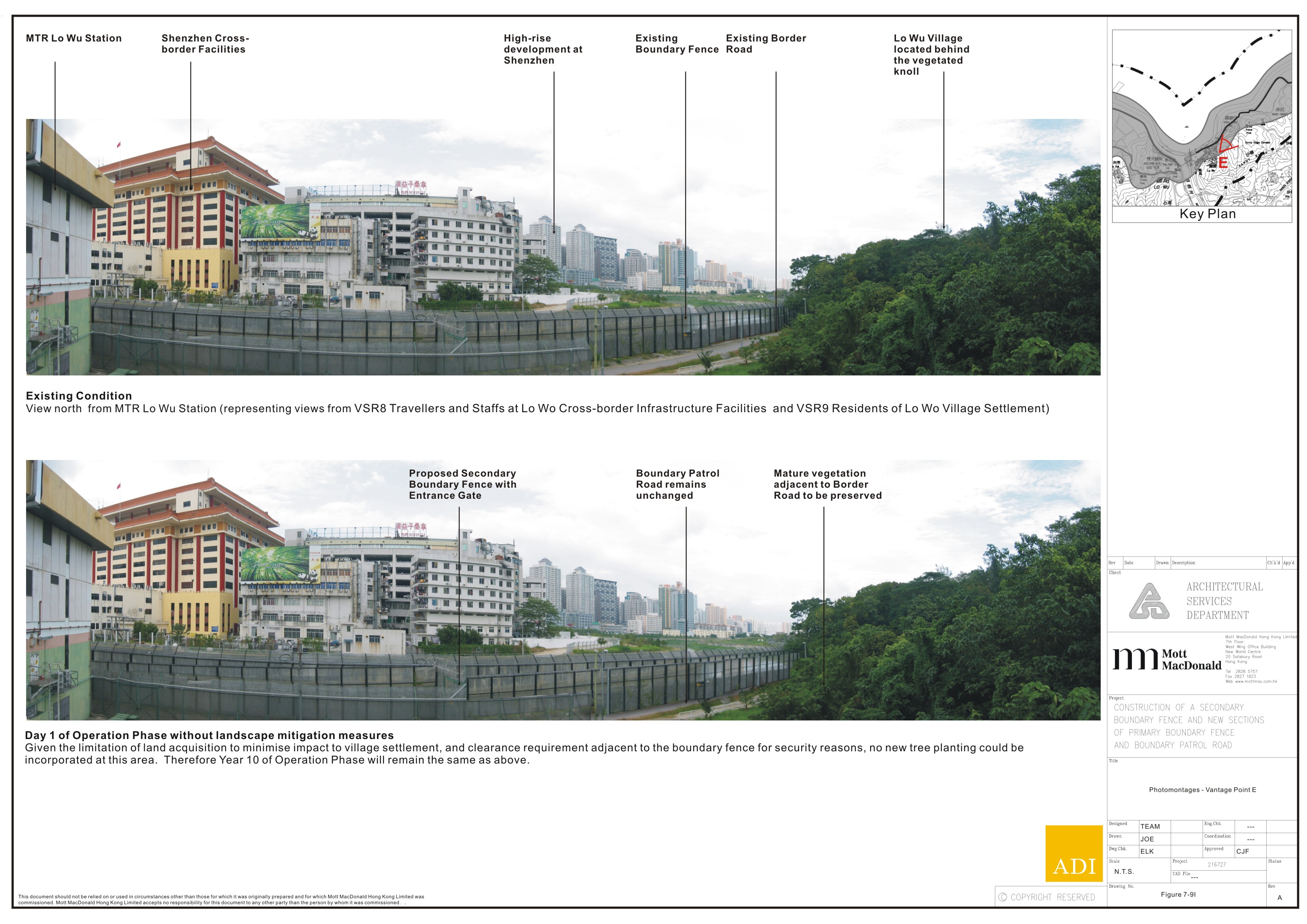
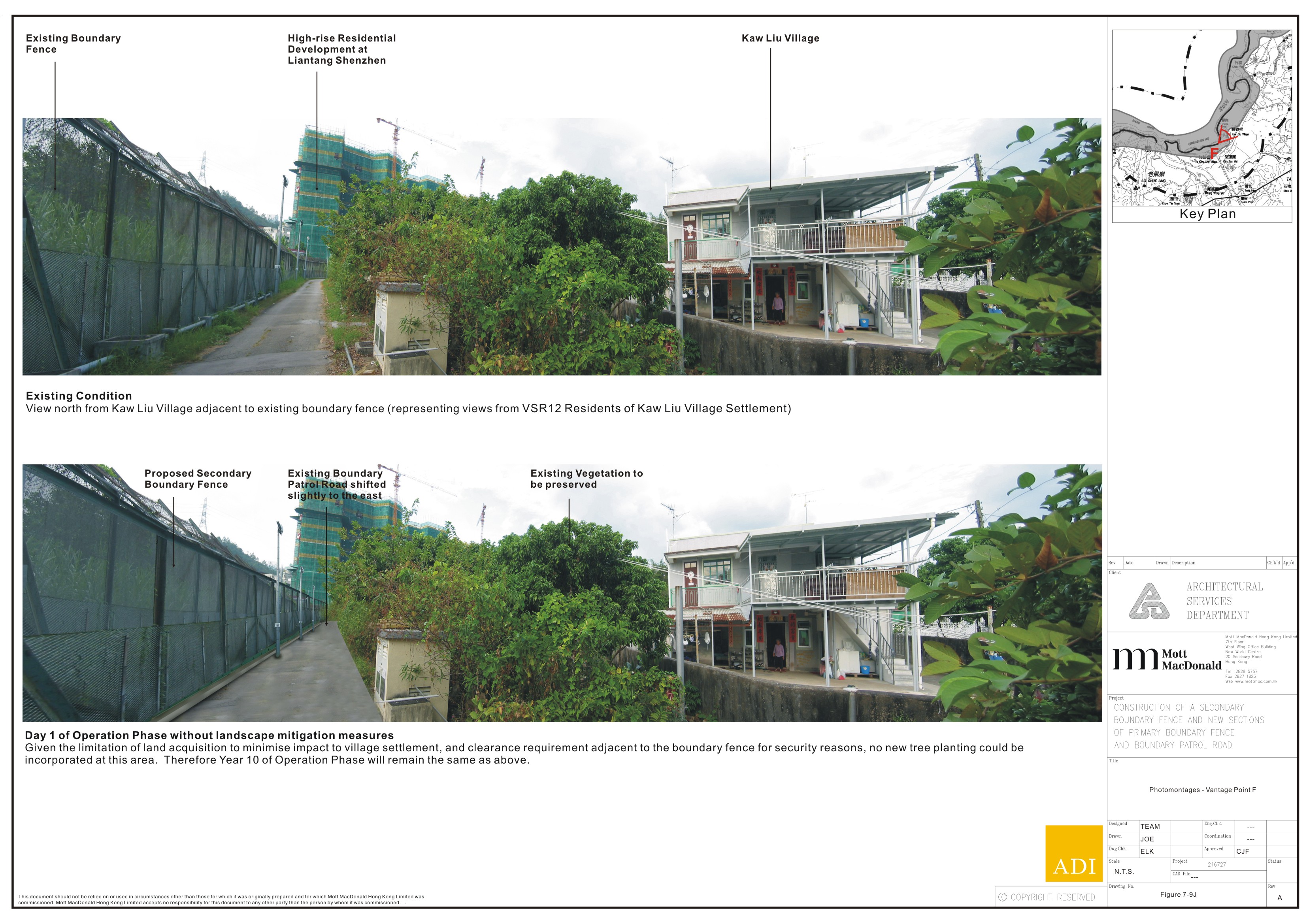
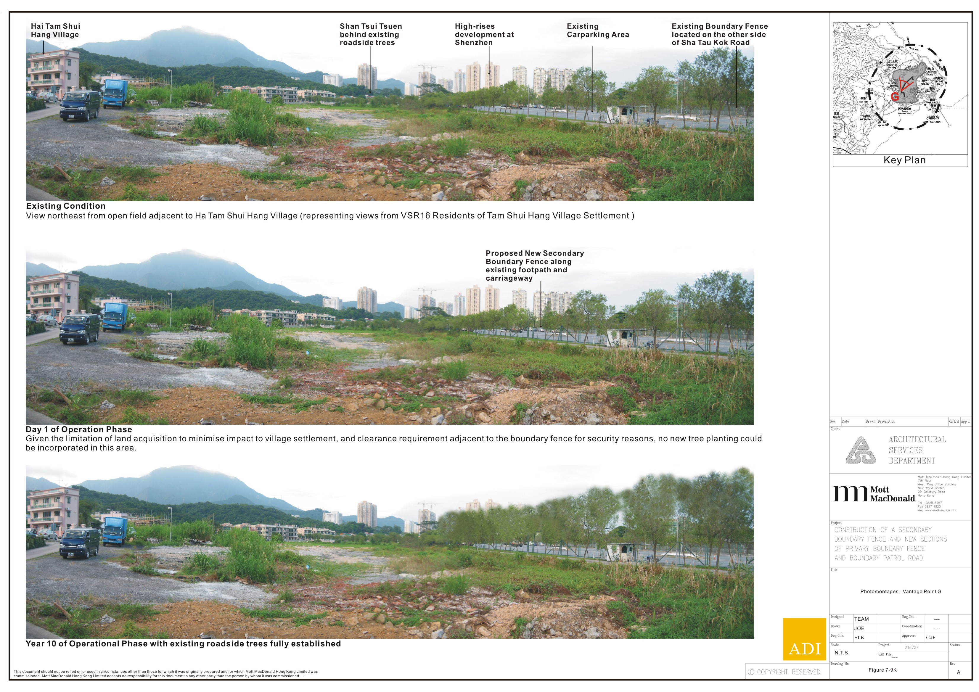
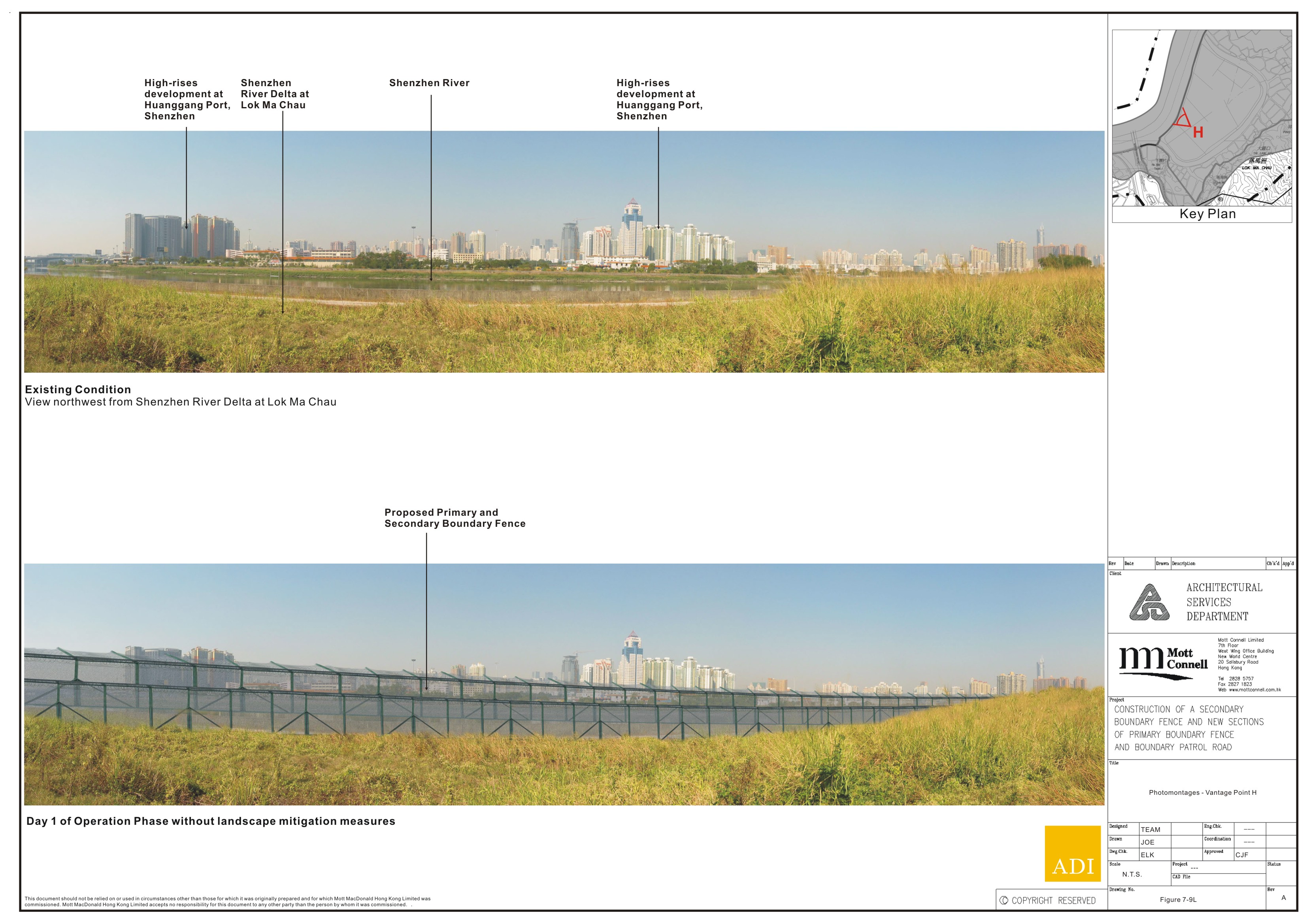
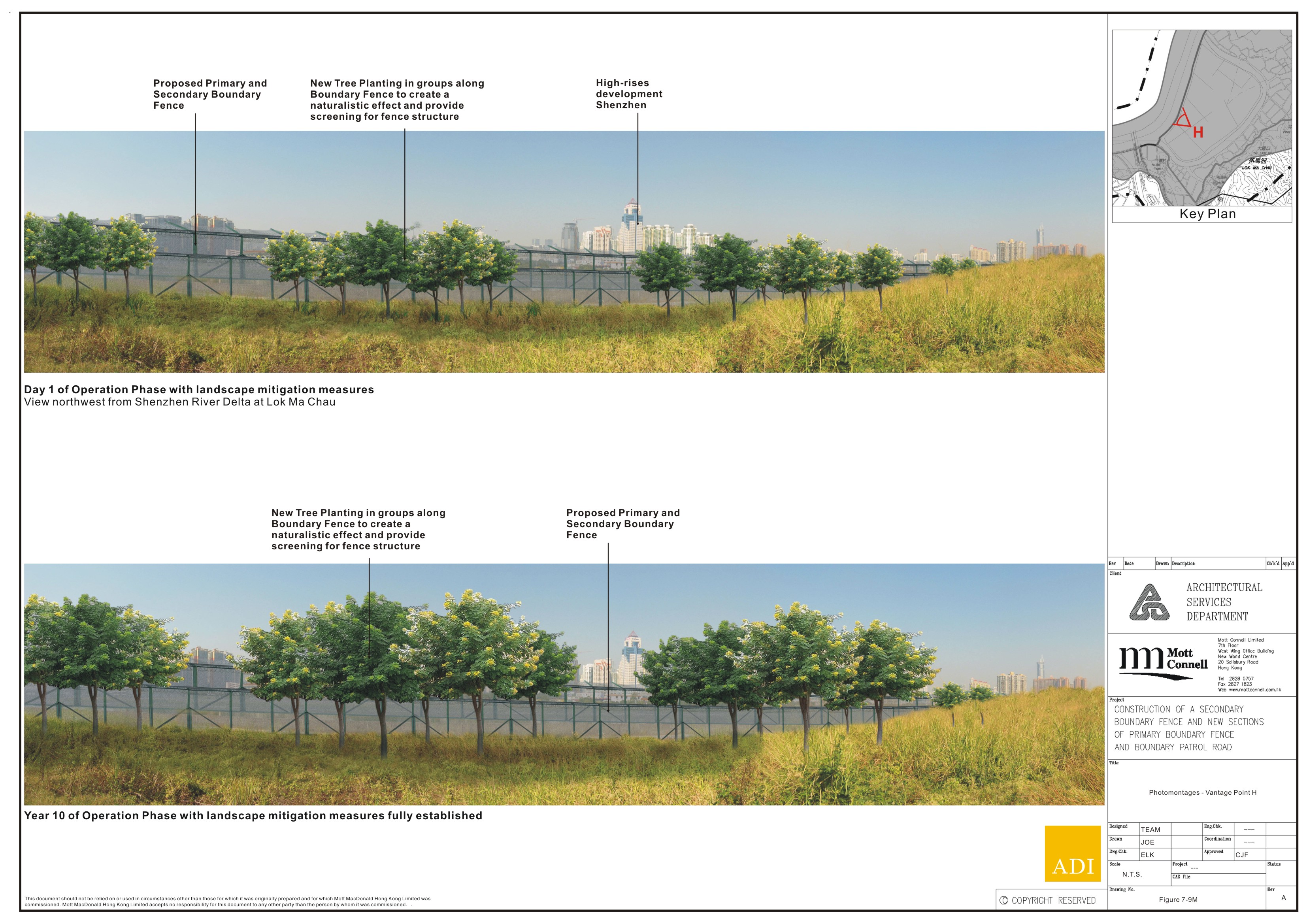